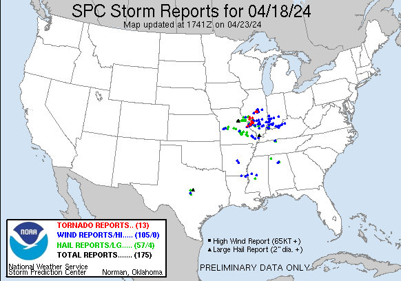
| Tornado Reports (CSV) (Raw Tornado CSV)(?) |
|---|
Time | | Location | County | State | Lat | Lon | Comments |
| 2212 | | 4 SE Athensville | Macoupin | IL | 3942 | 9014 | Video of a tornado taken from a business on Palmyra Rd from social media--time estimated from radar. (LSX) |
| 2233 | | 3 NW Byrnes Mill | Jefferson | MO | 3846 | 9062 | EF1 damage to buildings at business along Twin Rivers Road. Tornado Debris Signature (TDS) was observed on radar at this time. Survey is continuing. (LSX) |
| 2236 | | 1 W Kemper | Jersey | IL | 3922 | 9018 | Spotter reported a brief tornado touchdown. Storm survey did not find any damage so rated EFU. (LSX) |
| 2238 | | 1 SSW High Ridge | Jefferson | MO | 3846 | 9054 | Storm survey ongoing with EF0 tornado damage near High Ridge along Highway PP and along Hunning Road. This is a continuation of the track from Twin Rivers Road (norther (LSX) |
| 2252 | | 1 S Pontoon Beach | Madison | IL | 3871 | 9006 | Tree damage with winds up to 80 mph. NWS storm survey continues. (LSX) |
| 2252 | | 3 S Standard City | Macoupin | IL | 3931 | 8979 | A brief tornado touched down south of Standard City where it damaged the roofs of 3 farm sheds. The tornado moved southeast across South Standard City Rd where it cause (LSX) |
| 2258 | | 1 SE Cahokia | St. Clair | IL | 3855 | 9017 | The tornado touched down near the western edge of the Prairies of Cahokia Golf Course and moved east for about 1.1 miles where it lifted near the intersection of Carol (LSX) |
| 2301 | | 1 S Prairietown | Madison | IL | 3895 | 8992 | Corrects previous tstm wnd dmg report from 1 S Prairietown. Report from mPING: Trees uprooted or snapped; Roof blown off. NWS survey team found EF1 damage with max wind (LSX) |
| 2309 | | 3 SE Kuhn | Madison | IL | 3875 | 8983 | Tree damage (limbs snapped) and minor roof damage (shingles off) along Lower Marine Road. NWS storm survey continues. (LSX) |
| 2314 | | Marine | Madison | IL | 3879 | 8978 | Corrects previous tstm wnd dmg report from Marine. trees down ... trees in houses ... and powerlines down. NWS survey team determined the damage was from a EF0 tornado. M (LSX) |
| 0020 | | 1 WSW Latham | Logan | IL | 3996 | 8917 | NWS storm damage survey confirmed an EF-0 tornado with estimated peak winds of 85 mph near Latham ... IL. The damage path length is 1.11 miles and max width of 200 yds. (ILX) |
| 0022 | | 1 SE Latham | Logan | IL | 3995 | 8915 | NWS storm survey damage survey confirmed an EF-1 tornado with estimated peak winds of 95 mph in southeast Logan and northwest Macon counties that moved southeast and th (ILX) |
| 0037 | | 3 NNW Forsyth | Macon | IL | 3997 | 8897 | NWS storm damage survey confirmed an EF-1 tornado with estimated peak winds of 90 mph in Macon county 3 miles north-northwest of Forsyth. The damage path is 7 miles wit (ILX) |
| Hail Reports (CSV) (Raw Hail CSV)(?) |
|---|
Time | Size | Location | County | State | Lat | Lon | Comments |
| 1808 | 150 | 2 W Clinton | Henry | MO | 3837 | 9381 | Delayed social media report of minor hail damage to multiple vehicles just west of Clinton. Time based on social media report with location estimated from radar based o (EAX) |
| 1813 | 100 | Clinton | Henry | MO | 3837 | 9378 | Hail reported in downtown Clinton. Hail size was estimated. (EAX) |
| 1815 | 125 | Clinton | Henry | MO | 3837 | 9378 | Hail up to half dollar size reported in the city limits of Clinton. Time estimated from radar. (EAX) |
| 1815 | 100 | 1 ENE Clinton | Henry | MO | 3838 | 9375 | Quarter sized hail at Wilder RV in northeast Clinton. (EAX) |
| 1900 | 100 | 3 ESE Racket | Benton | MO | 3828 | 9343 | delayed report of quarter size hail at mm 84 near Truman Lake State Park. (SGF) |
| 1957 | 150 | 4 N Auxvasse | Audrain | MO | 3907 | 9190 | (LSX) |
| 1959 | 150 | 5 S Vandiver | Audrain | MO | 3909 | 9187 | (LSX) |
| 1959 | 200 | 4 SSW Mexico | Audrain | MO | 3912 | 9189 | (LSX) |
| 2005 | 200 | 2 SW Benton City | Audrain | MO | 3911 | 9179 | (LSX) |
| 2005 | 175 | 4 SSE Vandiver | Audrain | MO | 3911 | 9183 | time estimate from radar. (LSX) |
| 2005 | 100 | 3 SSE Vandiver | Audrain | MO | 3912 | 9183 | time estimate from radar. (LSX) |
| 2005 | 100 | 2 SSE Vandiver | Audrain | MO | 3914 | 9183 | time estimate from radar. (LSX) |
| 2015 | 100 | 1 S Eldon | Miller | MO | 3834 | 9258 | Photo received via social media of quarter size hail in Eldon ... MO. Time estimated via radar. (SGF) |
| 2015 | 150 | Eldon | Miller | MO | 3835 | 9258 | Pictures received via social media with the largest hailstone estimated at ping pong size. Time estimated via radar. (SGF) |
| 2026 | 175 | 1 W Pike | Pike | MO | 3946 | 9106 | Time is radar estimate. (LSX) |
| 2040 | 100 | 3 SW Middletown | Montgomery | MO | 3909 | 9146 | (LSX) |
| 2050 | 175 | Saint Elizabeth | Miller | MO | 3825 | 9227 | Golf ball sized hail estimated via image on social media. Time estimated via radar. (SGF) |
| 2100 | 100 | 4 SE New Hartford | Pike | MO | 3915 | 9123 | (LSX) |
| 2102 | 100 | 3 NE Hanceville | Cullman | AL | 3409 | 8672 | Quarter size hail in Center Hill. (HUN) |
| 2111 | 100 | 5 W Silex | Lincoln | MO | 3913 | 9114 | (LSX) |
| 2128 | 100 | 3 E Silex | Lincoln | MO | 3913 | 9100 | time estimate from radar. (LSX) |
| 2130 | 175 | 4 NE Davis | Lincoln | MO | 3910 | 9096 | Photo of hail estimated to be at least golf ball size from social media. (LSX) |
| 2136 | 100 | 1 NNE White Hall | Greene | IL | 3945 | 9040 | (LSX) |
| 2137 | 100 | Roodhouse | Greene | IL | 3948 | 9037 | (LSX) |
| 2140 | 100 | New Hope | Lincoln | MO | 3914 | 9086 | Photo of hail estimated to be at least quarter size on social media. (LSX) |
| 2140 | 175 | 3 ENE Roodhouse | Greene | IL | 3951 | 9033 | Observer also reported a horizontal roll cloud. (LSX) |
| 2145 | 200 | 3 S Cypress | Johnson | IL | 3732 | 8902 | Corrects previous hail report from 3 S Cypress. Delayed report. Hail larger than golfballs. (PAH) |
| 2146 | 150 | 3 S Cypress | Johnson | IL | 3732 | 8902 | Relayed via Facebook. (PAH) |
| 2155 | 125 | 1 ESE Rolla | Phelps | MO | 3794 | 9175 | Image sent in of half-dollar sized hail. Time estimated via radar. (SGF) |
| 2155 | 100 | 1 NW Rolla | Phelps | MO | 3796 | 9178 | Multiple reports of lots of quarter sized hail falling for several minutes. (SGF) |
| 2155 | 100 | 3 E Northwye | Phelps | MO | 3797 | 9170 | (SGF) |
| 2156 | 100 | 9 SSE Green Ridge | Pettis | MO | 3851 | 9332 | Delayed report of quarter size hail on the north side of Ionia. Time estimated from radar. (EAX) |
| 2202 | 125 | 3 ESE Northwye | Phelps | MO | 3795 | 9170 | Half dollar size hail. The hail storm itself lasted about 10 minutes downing twigs and leaves everywhere and leaving the ground covered with hail in its wake. (SGF) |
| 2207 | 225 | 14 WNW Evant | Hamilton | TX | 3158 | 9835 | Social media image of measured 2.25 inch hailstone. (FWD) |
| 2217 | 175 | 13 ENE Goldthwaite | Mills | TX | 3154 | 9838 | Social media report of golf ball sized hail. (FWD) |
| 2221 | 100 | 1 NNW Woodson Terrace | St. Louis | MO | 3875 | 9037 | Corrects previous hail report from 1 NNW Woodson Terrace. (LSX) |
| 2223 | 150 | 7 SSW Mullin | Mills | TX | 3147 | 9873 | Relayed image of multiple half dollar hail stones and a ping pong sized hail stone. Time estimated via radar. (FWD) |
| 2230 | 100 | 2 NNE Lecoma | Phelps | MO | 3780 | 9171 | Comment on social media with picture of hailstone next to quarter. (SGF) |
| 2245 | 175 | 3 S Salem | Dent | MO | 3760 | 9153 | Golf ball sized hail 3 miles south of Salem reported via law enforcement. (SGF) |
| 2248 | 100 | 1 NW Salem | Dent | MO | 3766 | 9155 | CoCoRAHS observer reported quarter size hail and minor leaf damage. (SGF) |
| 2251 | 100 | 2 SE Salem | Dent | MO | 3763 | 9150 | Report from mPING: Quarter (1.00 in.). (SGF) |
| 2302 | 125 | 1 ENE Cherryville | Crawford | MO | 3785 | 9127 | Time estimated from radar. (LSX) |
| 2304 | 150 | 2 S Benld | Macoupin | IL | 3906 | 8981 | Report from mPING: Ping Pong Ball (1.50 in.). (LSX) |
| 2315 | 150 | San Saba | San Saba | TX | 3120 | 9872 | Quarter to Ping Pong Ball sized hail reported in downtown San Saba. (SJT) |
| 2345 | 100 | Caledonia | Washington | MO | 3776 | 9077 | (LSX) |
| 2355 | 125 | Okawville | Washington | IL | 3843 | 8955 | (LSX) |
| 2356 | 100 | 2 E Coopertown | Robertson | TN | 3644 | 8693 | (OHX) |
| 0000 | 150 | 4 WSW Chappel | San Saba | TX | 3104 | 9864 | (SJT) |
| 0000 | 150 | 4 SSE Livingston | Madison | MS | 3250 | 9019 | Ping Pong size hail reported near Whisper Lake. (JAN) |
| 0002 | 100 | 2 S Addieville | Washington | IL | 3837 | 8949 | (LSX) |
| 0006 | 100 | 6 N Lesterville | Reynolds | MO | 3754 | 9083 | (LSX) |
| 0009 | 100 | 3 SSE Springfield | Robertson | TN | 3646 | 8685 | (OHX) |
| 0041 | 125 | Woodlawn | Jefferson | IL | 3833 | 8903 | Corrects previous hail report from Woodlawn. (PAH) |
| 0043 | 125 | Woodlawn | Jefferson | IL | 3833 | 8903 | (PAH) |
| 0107 | 100 | Annapolis | Iron | MO | 3736 | 9070 | (LSX) |
| 0222 | 100 | 3 E Darmstadt | Vanderburgh | IN | 3809 | 8753 | (PAH) |
| 1112 | 100 | 2 N Russellville | Franklin | AL | 3453 | 8773 | Quarter size hail reported north of Russellville ... AL. Time estimated based on radar. (HUN) |
| Wind Reports (CSV) (Raw Wind CSV)(?) |
|---|
Time | Speed | Location | County | State | Lat | Lon | Comments |
| 1410 | UNK | 3 NNW Beekman | Morehouse | LA | 3296 | 9190 | Law enforcement reported a tree down near Hughes Chapel Rd due to yesterdays storms. (JAN) |
| 1510 | UNK | 4 WSW Glen Allan | Issaquena | MS | 3300 | 9109 | A tree was reported down near Wynn Rd by law enforcement. (JAN) |
| 1741 | UNK | 5 NW Montrose | Henry | MO | 3830 | 9405 | Downed power lines and power outages near 1601 Road. Time estimated from radar. (EAX) |
| 1819 | UNK | 3 ENE Clinton | Henry | MO | 3839 | 9373 | Downed wires and power outages reported near 200P Road. Time estimated from radar. (EAX) |
| 2008 | UNK | Midnight | Humphreys | MS | 3306 | 9057 | Local law enforcement reported several down power poles across Midnight and the Silver City area. (JAN) |
| 2038 | UNK | 2 W Nebo | Pike | IL | 3944 | 9083 | Corrects previous tstm wnd dmg report from 2 W Nebo. In Pleasant Hill ... a trampoline was thrown into power line ... then tossed 80 ft up into a tree. A 2.5 ft section o (LSX) |
| 2040 | UNK | 5 S Good Hope | Cullman | AL | 3404 | 8688 | Trees down in Dodge City. (HUN) |
| 2053 | UNK | 1 W Hanceville | Cullman | AL | 3406 | 8678 | Trees and powerlines down near the intersection of Section Line and Magnolia Ave. (HUN) |
| 2054 | 74 | Nebo | Pike | IL | 3944 | 9079 | Time estimate from radar. also golf ball sized hail. (LSX) |
| 2058 | UNK | 1 W Oak Grove | West Carroll | LA | 3286 | 9141 | Local law enforcement reported a tree down on Hwy 879 near Oak Grove. (JAN) |
| 2118 | UNK | Pickens | Holmes | MS | 3288 | 8997 | A few trees and a power line were blown down across roads in Pickens. Pictures of the damage were relayed by broadcast media. (JAN) |
| 2155 | UNK | 2 WSW Rolla | Phelps | MO | 3794 | 9180 | Portion of a motel roof blown off. Reported by law enforcement and confirmed via images in NWSChat. Time estimated via radar. (SGF) |
| 2155 | UNK | 1 W Rolla | Phelps | MO | 3795 | 9178 | Police reported multiple wires and some trees down in Rolla. A 42 mph gust was also recorded just northeast of Rolla. Time estimated via radar. (SGF) |
| 2155 | UNK | 2 W Rolla | Phelps | MO | 3795 | 9181 | Tree uprooted just west of Rolla city limits. Location estimated. Time estimated via radar. (SGF) |
| 2210 | UNK | 3 SSW Mound City | Alexander | IL | 3705 | 8919 | Tree down across Highway 37 between Cairo and Mounds City. (PAH) |
| 2237 | UNK | Dittmer | Jefferson | MO | 3833 | 9068 | Photo of tree limb snapped and fallen on a home from social media. (LSX) |
| 2240 | UNK | 1 E East Carondelet | St. Clair | IL | 3854 | 9021 | location approximate ... time estimate from radar ... multiple trees and powerlines down. (LSX) |
| 2241 | UNK | 2 SW Lakeshire | St. Louis | MO | 3852 | 9036 | Report from mPING: 3-inch tree limbs broken; Power poles broken. (LSX) |
| 2243 | UNK | University City | St. Louis | MO | 3866 | 9034 | Report from mPING: 1-inch tree limbs broken; Shingles blown off. (LSX) |
| 2244 | UNK | 1 SW Fenton | St. Louis | MO | 3853 | 9047 | Flashing ripped off roof. (LSX) |
| 2245 | UNK | 2 S Sunset Hills | St. Louis | MO | 3850 | 9042 | Several downed treee branches. (LSX) |
| 2245 | UNK | 2 SW Lakeshire | St. Louis | MO | 3852 | 9035 | tree down ... time estimate from radar. (LSX) |
| 2248 | UNK | 1 W Mehlville | St. Louis | MO | 3850 | 9034 | A few shingles blown off of roofs. (LSX) |
| 2249 | UNK | 2 SW Lakeshire | St. Louis | MO | 3852 | 9036 | Medium diameter tree broke at mid point from top. (LSX) |
| 2250 | UNK | 2 N Arnold | Jefferson | MO | 3845 | 9037 | Report from mPING: 1-inch tree limbs broken; Shingles blown off. (LSX) |
| 2250 | UNK | 2 NW Arnold | Jefferson | MO | 3845 | 9040 | Report from mPING: 1-inch tree limbs broken; Shingles blown off. (LSX) |
| 2250 | UNK | 1 WNW Mehlville | St. Louis | MO | 3851 | 9034 | Photo of large portion of pine tree fallen on the ground from social media. (LSX) |
| 2250 | UNK | 2 SW Lakeshire | St. Louis | MO | 3851 | 9036 | Multiple large trees blown over. One of the fallen trees blocked a road ... and another fallen tree fell on a neighborhood house. (LSX) |
| 2251 | UNK | 1 NNE Oakville | St. Louis | MO | 3846 | 9031 | 2-3inch live limbs down ... 2-3 up-rooted trees ... shingles off ... bent trees. (LSX) |
| 2251 | UNK | 1 NW Mehlville | St. Louis | MO | 3851 | 9034 | Report from mPING: 3-inch tree limbs broken; Power poles broken. (LSX) |
| 2251 | UNK | 1 N Mehlville | St. Louis | MO | 3852 | 9031 | Photo of multiple large tree limbs down at Covington Manor Ln and Lemay Ferry Rd. (LSX) |
| 2251 | UNK | 2 SE Sunset Hills | St. Louis | MO | 3852 | 9039 | Report from mPING: 1-inch tree limbs broken; Shingles blown off. (LSX) |
| 2252 | UNK | 2 NE Oakville | St. Louis | MO | 3847 | 9030 | Report from mPING: Trees uprooted or snapped; Roof blown off. (LSX) |
| 2254 | UNK | 1 WNW Mehlville | St. Louis | MO | 3851 | 9034 | Turn signal light blown down by thunderstorm winds. (LSX) |
| 2257 | UNK | 2 NW Columbia | Monroe | IL | 3848 | 9025 | Report from mPING: 1-inch tree limbs broken; Shingles blown off. (LSX) |
| 2257 | UNK | 1 SW Dupo | St. Clair | IL | 3850 | 9023 | Report from mPING: 3-inch tree limbs broken; Power poles broken. (LSX) |
| 2302 | UNK | 1 S Prairietown | Madison | IL | 3895 | 8992 | Report from mPING: Trees uprooted or snapped; Roof blown off. (LSX) |
| 2305 | UNK | 1 E Troy | Madison | IL | 3873 | 8988 | Large tree blown over. (LSX) |
| 2306 | UNK | Worden | Madison | IL | 3893 | 8984 | power poles down. (LSX) |
| 2314 | UNK | Marine | Madison | IL | 3879 | 8978 | Corrects previous tornado report from Marine. Corrects previous tstm wnd dmg report from Marine. trees down ... trees in houses ... and powerlines down. (LSX) |
| 2315 | UNK | 2 ESE Centreville | St. Clair | IL | 3857 | 9007 | Downed tree and powerlines. (LSX) |
| 2315 | UNK | Marine | Madison | IL | 3879 | 8978 | trees down ... trees in houses ... and powerlines down. (LSX) |
| 2318 | UNK | 1 E O'Fallon | St. Clair | IL | 3860 | 8990 | Report from mPING: 3-inch tree limbs broken; Power poles broken. (LSX) |
| 2318 | UNK | New Douglas | Madison | IL | 3897 | 8967 | power poles down. (LSX) |
| 2318 | UNK | 2 WNW New Douglas | Madison | IL | 3898 | 8970 | Photo of a tree snapped in half at Rustic Acres Jellystone Park from social media. (LSX) |
| 2319 | UNK | 1 NW Fairview Heights | St. Clair | IL | 3861 | 9001 | Report from mPING: 3-inch tree limbs broken; Power poles broken. (LSX) |
| 2320 | UNK | San Saba | San Saba | TX | 3120 | 9872 | Multiple trees down across the city of San Saba. (SJT) |
| 2355 | UNK | 1 ENE Okawville | Washington | IL | 3844 | 8953 | Tree debris was found off of I-64 at the Okawville exit. Time estimated from radar. (LSX) |
| 2355 | UNK | 2 SW Hagerstown | Fayette | IL | 3893 | 8919 | Corrects previous tstm wnd dmg report from 2 SW Hagerstown. Trees downed across Illinois Route 140 at 300 St and just east of Hagerstown. Time estimated from radar. (LSX) |
| 2357 | UNK | Riverton | Sangamon | IL | 3985 | 8954 | Numerous trees were blown down from Riverton eastward. (ILX) |
| 0014 | UNK | Springfield | Robertson | TN | 3650 | 8688 | A tree fell on a house on Shelton St causing minor to moderate damage to the house. (OHX) |
| 0018 | UNK | 1 E Junction City | Marion | IL | 3858 | 8910 | Report from mPING: Trees uprooted or snapped; Roof blown off. (LSX) |
| 0018 | UNK | 2 ESE Mount Pulaski | Logan | IL | 3999 | 8925 | Three power poles are leaning near the intersection of Route 121 and 1842nd Avenue. (ILX) |
| 0019 | UNK | 3 WSW Latham | Logan | IL | 3995 | 8922 | Corrects previous tstm wnd dmg report from 3 WSW Latham. Several trees were down ... but no structural damage was noted in this area. (Previous report was roof damage). (ILX) |
| 0020 | UNK | 1 E Junction City | Marion | IL | 3858 | 8911 | Report from mPING: 3-inch tree limbs broken; Power poles broken. (LSX) |
| 0020 | UNK | Latham | Logan | IL | 3997 | 8916 | A tree was blown down. (ILX) |
| 0022 | UNK | Centralia | Marion | IL | 3853 | 8913 | trees and limbs down. (LSX) |
| 0022 | UNK | Brownstown | Fayette | IL | 3900 | 8895 | Trees downed in the Brownstown area. Time estimated from radar. (LSX) |
| 0025 | UNK | 1 N Kinmundy | Marion | IL | 3879 | 8885 | Marion County Sheriffs Office reported a tree down on St. Peter Road at I-57. Time estimated from radar. (LSX) |
| 0029 | UNK | Warrensburg | Macon | IL | 3993 | 8906 | Delayed report. Roof blown off house. (ILX) |
| 0034 | UNK | 5 ENE Kell | Marion | IL | 3852 | 8882 | Marion County Sheriffs Office reported a tree on State Route 161 Extension at Lincoln Road. Time estimated by radar. (LSX) |
| 0034 | UNK | 3 SW Forsyth | Macon | IL | 3990 | 8900 | Delayed report. Semi blown over on I-72 at Mile Marker 139. (ILX) |
| 0035 | UNK | Salem | Marion | IL | 3863 | 8895 | tree limbs down. (LSX) |
| 0037 | UNK | 4 N Forsyth | Macon | IL | 3998 | 8895 | Delayed report. Semi blown over on Emery Road near Route 51. (ILX) |
| 0038 | UNK | Clinton | De Witt | IL | 4015 | 8896 | Numerous power lines were blown down. (ILX) |
| 0044 | UNK | 5 E Sesser | Franklin | IL | 3808 | 8896 | Tree down on Highway 37 at Gun Creek. (PAH) |
| 0045 | UNK | 2 NE Oreana | Macon | IL | 3996 | 8885 | Power poles tilted over on route 48 between Oreana and Argenta. Time estimated from radar. (ILX) |
| 0047 | UNK | 2 S Argenta | Macon | IL | 3996 | 8882 | Delayed report. Semi blown over on Interstate 72 at mile marker 150. (ILX) |
| 0049 | UNK | 3 S Dieterich | Effingham | IL | 3902 | 8838 | Delayed report. Large tree blown over. (ILX) |
| 0049 | UNK | Argenta | Macon | IL | 3998 | 8882 | Delayed report. Social media images show a destroyed grain bin and a damaged farm outbuilding. (ILX) |
| 0053 | UNK | 3 E Clinton | De Witt | IL | 4016 | 8891 | Delayed report. Garage roof blown off. Four utility poles and multiple trees blown down. Time estimated by radar. (ILX) |
| 0113 | 58 | 4 N Belle Prairie City | Wayne | IL | 3828 | 8856 | Measured 1 mile north of mile marker 100 on Interstate 64. (PAH) |
| 0115 | UNK | Fairfield | Wayne | IL | 3838 | 8836 | A large tree fell onto a trailer home. (PAH) |
| 0118 | UNK | 3 S Fairfield | Wayne | IL | 3834 | 8836 | Metal roof blown off a large building along US 45 at County Road 620 North. Relayed via Twitter. (PAH) |
| 0135 | UNK | 3 S Sumner | Lawrence | IL | 3867 | 8786 | Several large trees down. (ILX) |
| 0140 | UNK | 1 SW Champaign | Champaign | IL | 4010 | 8828 | report of a power line down into a tree. KCMI gusted to 52 mph with storms. (ILX) |
| 0142 | UNK | 2 WSW Urbana | Champaign | IL | 4010 | 8823 | Delayed report. Tree down at Grange Grove. (ILX) |
| 0152 | UNK | 6 W Glenallen | Bollinger | MO | 3730 | 9013 | Delayed Report. A few trees down ... 1 shed with roof blown off ... 1 small shed blown over. 2 tractor trailer cab shells blown over. Near intersection off DD and County (PAH) |
| 0200 | 60 | 1 SSW Sullivan | Sullivan | IN | 3908 | 8742 | (IND) |
| 0208 | UNK | Vincennes | Knox | IN | 3868 | 8751 | Starting to get reports of trees and utility lines down within Vincennes. (IND) |
| 0211 | UNK | Princeton | Gibson | IN | 3836 | 8757 | Tree uprooted on the south side of Princeton. (PAH) |
| 0213 | UNK | 9 SSE Poseyville | Posey | IN | 3805 | 8773 | Delayed Report. A couple trees down. Dime size hail. Report received via social media. (PAH) |
| 0213 | UNK | 3 SSW Vincennes | Knox | IN | 3864 | 8753 | Report of a semi overturned on US 41 near Vincennes. (IND) |
| 0213 | 60 | Bicknell | Knox | IN | 3878 | 8731 | (IND) |
| 0215 | UNK | 1 N Pimento | Vigo | IN | 3933 | 8739 | 11419 Sugar Lane about 6 miles south of Terre Haute ... .several large trees down. (IND) |
| 0222 | UNK | 5 NNW Advance | Bollinger | MO | 3717 | 8995 | Delayed report. A couple trees down south of Marble Hill. (PAH) |
| 0223 | UNK | 3 W Lyons | Greene | IN | 3899 | 8714 | Tree down across 1050W west of Lyons. (IND) |
| 0227 | UNK | 4 W Evansville | Vanderburgh | IN | 3798 | 8761 | Tree down on S Barker near Edgewood. (PAH) |
| 0233 | UNK | Winslow | Pike | IN | 3838 | 8721 | Delayed Report. Multiple large tree limbs down 4 to 5 inches in diameter. Report received via social media. (PAH) |
| 0239 | UNK | 3 S Solsberry | Greene | IN | 3904 | 8675 | Multiple tree limbs and branches downed along State Route 54 near Eastern Greene Middle School. (IND) |
| 0242 | UNK | 2 E Duff | Dubois | IN | 3830 | 8701 | Dispatch reported tree in roadway on SR64 2 miles east of SR161. Time estimated from radar. (LMK) |
| 0245 | UNK | 3 NE Ireland | Dubois | IN | 3844 | 8696 | Tree and power line on fire in the 2500 block of N Portersville Rd. Time estimated from radar. (LMK) |
| 0251 | UNK | 3 SW Kellerville | Dubois | IN | 3845 | 8687 | Tree in roadway on County Road 175E. (LMK) |
| 0310 | UNK | Vanduser | Scott | MO | 3699 | 8969 | Delayed report. A couple trees down. (PAH) |
| 0313 | UNK | 1 N Bandon | Perry | IN | 3815 | 8660 | Tree down on State Road 37 near Branchville. (LMK) |
| 0337 | UNK | New Amsterdam | Harrison | IN | 3810 | 8627 | Trees down in downtown New Amsterdam. (LMK) |
| 0340 | UNK | 1 SW Valley City | Harrison | IN | 3809 | 8622 | Trees down over New Amsterdam Road in Valley City. (LMK) |
| 0345 | UNK | 4 WSW Columbus | Bartholomew | IN | 3918 | 8599 | A live ... well established pine tree was snapped at its base in a neighborhood in the Tipton Lakes area. (IND) |
| 0347 | UNK | 2 NNW Laconia | Harrison | IN | 3806 | 8611 | Tree down on Beech Road. (LMK) |
| 0355 | UNK | 3 WSW Garrett | Meade | KY | 3789 | 8616 | Tree down over Highway 60 near Hill Grove. (LMK) |
| 0412 | 62 | 1 NNE Louisville Int'l | Jefferson | KY | 3818 | 8573 | Measured at Louisville Muhammad Ali International Airport. (LMK) |
| 0417 | UNK | 1 W Saint Matthews | Jefferson | KY | 3825 | 8566 | A large tree fell onto a house in St Matthews ... resulting in damage to the house. (LMK) |
| 0455 | 63 | 4 E Chestnut Grove | Shelby | KY | 3830 | 8520 | Measured at the KY Mesonet station CROP. (LMK) |
| 0642 | 63 | 6 SW Little Rock | Pulaski | AR | 3468 | 9238 | (LZK) |
| 0738 | UNK | Redfield | Jefferson | AR | 3444 | 9219 | Multiple trees and power lines down in the town of Redfield. Damage also noted to a mobile home that a tree fell on and to the roof of a church. (LZK) |


 @NWSSPC