|
20110413's Storm Report (1200 UTC - 1159 UTC)
|
< 110412 Reports
110414 Reports >
|
|
| Note: All data are considered preliminary |
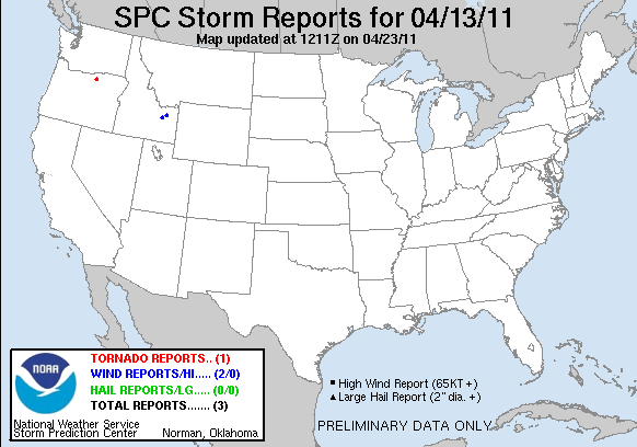
| Tornado Reports (CSV) (Raw Tornado CSV)(?) |
|---|
Time | | Location | County | State | Lat | Lon | Comments |
| 2315 | | 2 SSW LEXINGTON | MORROW | OR | 4542 | 11971 | AN EF0 TORNADO WAS SPOTTED BY A CIVILIAN ABOUT 10 YARDS WIDE THAT MOVED SOUTHEAST FOR ONE TENTH OF A MILE. THIS OCCURED FROM 1615 PDT TO 1616 PDT. CIVILIAN OBSERVED THE (PDT) |
| Hail Reports (CSV) (Raw Hail CSV)(?) |
|---|
| No reports received |
| Wind Reports (CSV) (Raw Wind CSV)(?) |
|---|
Time | Speed | Location | County | State | Lat | Lon | Comments |
| 2205 | 64 | 9 SSW TERRETON | JEFFERSON | ID | 4372 | 11253 | SUSTAINED WINDS AT 50 MPH (PIH) |
| 2245 | 61 | HAMER | JEFFERSON | ID | 4393 | 11220 | 61 MPH WIND GUST (PIH) |
| Full report
in comma-separated values (CSV) format and in KML format. |
| Raw full report
in comma-separated values (CSV) format |
| Fields marked UNK are unknown |
| All Times UTC |
| Wind Gusts in MPH |
| Hail Sizes in 1/100 of an Inch (175 = 1.75") |
| LAT/LON in decimal degrees to two decimals, see SPC FAQ for more info |
| List of Weather Forecast Office 3-letter IDs appear in the report comments section |
|
|
|
Top/Storm Reports/Home
|
|


 @NWSSPC