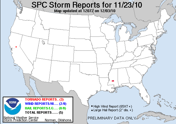
20101123's Storm Report (1200 UTC - 1159 UTC)
|
< 101122 Reports
101124 Reports >
|
|
| Note: All data are considered preliminary |
| Tornado Reports (CSV) (Raw Tornado CSV)(?) |
|---|
Time | | Location | County | State | Lat | Lon | Comments |
| 1630 | | 2 NW HARRISVILLE | SIMPSON | MS | 3199 | 9010 | ESTIMATED MAXIMUM WINDS 100 MPH ... PATH LENGTH 8 MILES ... MAXIMUM WIDTH 150 YARDS. TORNADO TOUCHED DOWN ALONG MS 469 JUST NW OF HARRISVILLE ... MOVING ENE. DOWNED NUMEROUS (JAN) |
| 1735 | | 2 NE MARTINVILLE | SIMPSON | MS | 3199 | 8973 | ESTIMATED MAXIMUM WINDS 95 MPH ... PATH LENGTH 2.5 MILES ... MAXIMUM WIDTH 75 YARDS. TORNADO TOUCHED DOWN NEAR THE INTERSECTION OF WARREN RD AND WARREN COOK RD. THE TORNADO (JAN) |
| 2117 | | 4 S EL DORADO HILLS | SACRAMENTO | CA | 3863 | 12108 | AN EF1 TORNADO DEVELOPED NEAR LATROBE IN EL DORADO COUNTY. WINDS ARE ESTIMATED AT 100 MPH WITH A DAMAGE PATH OF TWO MILES. THERE WAS DAMAGE TO THE ROOF OF A COMMERCIAL (STO) |
| Hail Reports (CSV) (Raw Hail CSV)(?) |
|---|
| No reports received |
| Wind Reports (CSV) (Raw Wind CSV)(?) |
|---|
Time | Speed | Location | County | State | Lat | Lon | Comments |
| 1710 | UNK | 1 N MENDENHALL | SIMPSON | MS | 3198 | 8987 | A FEW TREES REPORTED DOWN ALONG WITH A COUPLE OF HOMES DAMAGED. (JAN) |
| 1730 | UNK | 1 N MARTINVILLE | SIMPSON | MS | 3199 | 8975 | 3 HOMES AND 3 CHICKEN HOUSES DAMAGED. (JAN) |
| Full report
in comma-separated values (CSV) format and in KML format.
|
| Raw full report
in comma-separated values (CSV) format |
| Click here to find out the differences between the regular and raw CSV files. |
| Fields marked UNK are unknown |
| All Times UTC |
| Wind Gusts in MPH |
| Hail Sizes in 1/100 of an Inch (175 = 1.75") |
| LAT/LON in decimal degrees to two decimals, see SPC FAQ for more info |
| List of Weather Forecast Office 3-letter IDs appear in the report comments section |
|
|
|
Top/Storm Reports/Home
|


 @NWSSPC