|
|
< 101020 Reports
101022 Reports >
|
|
| Note: All data are considered preliminary |
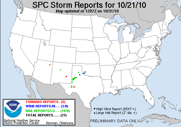
| Tornado Reports (CSV) (Raw Tornado CSV)(?) |
|---|
| Time | | Location | County | State | Lat | Lon | Comments |
|---|
| 2248 | | 2 SW RANKIN | UPTON | TX | 3120 | 10196 | BRIEF TORNADO TOUCHDOWN ON US 67 2 MILES SW OF RANKIN. TORNADO LIFTED AT 550. (MAF) |
| 2334 | | 15 W CHINLE | APACHE | AZ | 3615 | 10985 | A TORNADO WAS OBSERVED TOUCHING DOWN BETWEEN COTTONWOOD AND BLUE GAP. TREES AND BUSHES IN THE AREA WERE KNOCKED DOWN. (FGZ) |
| 2347 | | 16 NW BITTER LAKE WILDL | CHAVES | NM | 3361 | 10463 | (ABQ) |
| 2356 | | 18 NW BITTER LAKE WILDL | CHAVES | NM | 3364 | 10463 | CONFIRMED SECOND REPORT. TORNADO STILL ON GROUND. TORNADO PERSISTENT FOR PAST 10 MINUTES (ABQ) |
| 0003 | | 18 NW BITTER LAKE WILDL | CHAVES | NM | 3368 | 10459 | (ABQ) |
| Hail Reports (CSV) (Raw Hail CSV)(?) |
|---|
| Time | Size | Location | County | State | Lat | Lon | Comments |
|---|
| 2000 | 100 | 10 SW CLARENDON | DONLEY | TX | 3483 | 10102 | (AMA) |
| 2008 | 175 | 11 N FORT STOCKTON | PECOS | TX | 3105 | 10289 | (MAF) |
| 2044 | 175 | TOKIO | TERRY | TX | 3318 | 10257 | HAIL COVERING THE GROUND. (LUB) |
| 2044 | 175 | 9 E PLAINS | YOAKUM | TX | 3319 | 10267 | HAIL COVERING THE GROUND. (LUB) |
| 2105 | 175 | TOKIO | TERRY | TX | 3318 | 10257 | QUARTER TO GOLFBALL HAIL REPORTED IN TOKIO. (LUB) |
| 2140 | 100 | 10 N GIRVIN | CRANE | TX | 3121 | 10239 | QUARTER AND LARGER HAIL 5-10 MILES NORTH OF GIRVIN. HAIL COVERS FM11 AND IS ONE INCH DEEP. (MAF) |
| 2143 | 175 | ROYALTY | WARD | TX | 3137 | 10287 | (MAF) |
| 2210 | 175 | MEADOW | TERRY | TX | 3334 | 10221 | (LUB) |
| 2242 | 100 | 8 ENE ALBUQUERQUE | BERNALILLO | NM | 3516 | 10650 | SPAIN AND TRAMWAY. (ABQ) |
| 2245 | 100 | 7 S SEAGRAVES | GAINES | TX | 3284 | 10257 | A FEW HALF DOLLARS MIXED IN WITH THE QUARTER HAIL. (MAF) |
| 2245 | 150 | BROWNFIELD | TERRY | TX | 3318 | 10227 | (LUB) |
| 2305 | 175 | LUBBOCK | LUBBOCK | TX | 3358 | 10188 | REPORTED AT 55TH AND UTICA. (LUB) |
| 2340 | 100 | WELLMAN | TERRY | TX | 3305 | 10243 | TIME ESTIMATED. (LUB) |
| 2349 | 100 | 9 W ANDREWS | ANDREWS | TX | 3234 | 10269 | QUARTER SIZE HAIL REPORTED ON THE GROUND JUST WEST OF THE INTERSECTION OF COUNTY ROAD 3901 AND STATE HIGHWAY 176 (MAF) |
| 0145 | 175 | 4 NW BROWNFIELD | TERRY | TX | 3322 | 10232 | (LUB) |
| 0200 | 150 | 4 E BROWNFIELD | TERRY | TX | 3318 | 10220 | QUARTER TO PING PONG BALL SIZED HAIL REPORTED AT TERRY COUNTY AIRPORT. (LUB) |
| 0230 | 100 | 3 N SLATON | LUBBOCK | TX | 3348 | 10164 | NICKEL TO QUARTER SIZED HAIL REPORTED NORTH OF SLATON. TIME ESTIMATED. (LUB) |
| 0230 | 175 | DUKE | JACKSON | OK | 3467 | 9958 | (OUN) |
| 0235 | 150 | 7 W NEW HOME | LYNN | TX | 3333 | 10203 | QUARTER TO PING PONG BALL SIZED HAIL REPORTED IN LAKEVIEW. TIME ESTIMATED. (LUB) |
| Wind Reports (CSV) (Raw Wind CSV)(?) |
|---|
| Time | Speed | Location | County | State | Lat | Lon | Comments |
|---|
| 0200 | 61 | 1 S NORTHFIELD | MOTLEY | TX | 3427 | 10060 | (LUB) |
| 0355 | 58 | 4 SE HOBART | KIOWA | OK | 3499 | 9904 | HBR ASOS (OUN) |
| 0400 | 64 | ALTUS | JACKSON | OK | 3464 | 9933 | ALTUS AFB ASOS (OUN) |
| Full report
in comma-separated values (CSV) format and in KML format.
|
| Raw full report
in comma-separated values (CSV) format |
| Click here to find out the differences between the regular and raw CSV files. |
| Fields marked UNK are unknown |
| All Times UTC |
| Wind Gusts in MPH |
| Hail Sizes in 1/100 of an Inch (175 = 1.75") |
| LAT/LON in decimal degrees to two decimals, see SPC FAQ for more info |
| List of Weather Forecast Office 3-letter IDs appear in the report comments section |
|
|
|
Top/Storm Reports/Home
|


 @NWSSPC