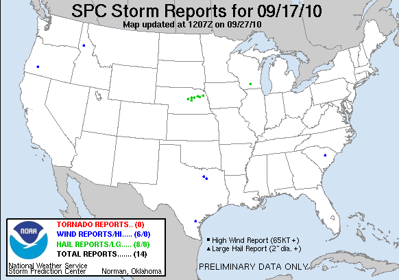
20100917's Storm Report (1200 UTC - 1159 UTC)
|
< 100916 Reports
100918 Reports >
|
|
| Note: All data are considered preliminary |
| Tornado Reports (CSV) (Raw Tornado CSV)(?) |
|---|
| No reports received |
| Hail Reports (CSV) (Raw Hail CSV)(?) |
|---|
Time | Size | Location | County | State | Lat | Lon | Comments |
| 0443 | 100 | ELYRIA | VALLEY | NE | 4168 | 9901 | QUARTER SIZE HAIL AND STRONG WINDS (GID) |
| 0506 | 175 | PETERSBURG | BOONE | NE | 4185 | 9808 | (OAX) |
| 0535 | 100 | BARTLETT | WHEELER | NE | 4188 | 9855 | THIS IS A DELAYED REPORT. (LBF) |
| 0547 | 100 | BATTLE CREEK | MADISON | NE | 4200 | 9760 | (OAX) |
| 0550 | 150 | GREELEY | GREELEY | NE | 4155 | 9853 | (GID) |
| 0555 | 100 | STANTON | STANTON | NE | 4195 | 9722 | (OAX) |
| 0641 | 175 | 2 SW PENDER | THURSTON | NE | 4209 | 9674 | QUARTER TO GOLFBALL SIZED HAIL. (OAX) |
| 0852 | 175 | SHOREWOOD HILLS | DANE | WI | 4308 | 8945 | (MKX) |
| Wind Reports (CSV) (Raw Wind CSV)(?) |
|---|
Time | Speed | Location | County | State | Lat | Lon | Comments |
| 1933 | 60 | NW SANDIA | JIM WELLS | TX | 2801 | 9788 | PUBLIC REPORT OF ESTIMATED GUST FROM 60 TO 65 MPH JUST ON THE WEST SIDE OF LAKE CORPUS CHRISTI NEAR THE LAGARTO STORE (CRP) |
| 2125 | UNK | FORNEY | KAUFMAN | TX | 3275 | 9647 | FORNEY PD REPORTS WIND DAMAGE TO THE DAIRY QUEEN ON US80 NEAR PINSON ROAD. (FWD) |
| 2234 | 60 | ADDISON | DALLAS | TX | 3295 | 9682 | ADDISON AIRPORT REPORTED A 52 KNOT WIND GUST. (FWD) |
| 2325 | UNK | 6 ENE SOUTH SUMTER | SUMTER | SC | 3393 | 8025 | LARGE LIMBS DOWN, SIDE OF SHOP WALL BLOWN OUT. (CAE) |
| 0025 | UNK | UNION CREEK | JACKSON | OR | 4291 | 12244 | A 24 INCH DIAMETER TREE OR TREE LIMB FELL DURING THE THUNDERSTORM. IT LANDED ON A CABIN. THE CALLER DID NOT HAVE AN ESTIMATED WIND SPEED. PEA SIZED HAIL AND BRIEF HEAVY (MFR) |
| 0900 | UNK | 6 ESE OROFINO | CLEARWATER | ID | 4645 | 11614 | NUMEROUS BLOW DOWNS THROUGHOUT CLEARWATER COUNTY. SPOTTER REPORTED 18 AND 20 INCH DIAMETER TREES BROKEN AT BASE AND MID-SECTION RESPECTIVELY. POWER AND PHONE SERVICE KN (MSO) |
| Full report
in comma-separated values (CSV) format and in KML format.
|
| Raw full report
in comma-separated values (CSV) format |
| Click here to find out the differences between the regular and raw CSV files. |
| Fields marked UNK are unknown |
| All Times UTC |
| Wind Gusts in MPH |
| Hail Sizes in 1/100 of an Inch (175 = 1.75") |
| LAT/LON in decimal degrees to two decimals, see SPC FAQ for more info |
| List of Weather Forecast Office 3-letter IDs appear in the report comments section |
|
|
|
Top/Storm Reports/Home
|


 @NWSSPC