 Note:
The expiration time in the watch graphic is amended if the watch is
replaced, cancelled or extended.
Note:
Note:
The expiration time in the watch graphic is amended if the watch is
replaced, cancelled or extended.
Note: Click for
Watch Status Reports.
SEL3
URGENT - IMMEDIATE BROADCAST REQUESTED
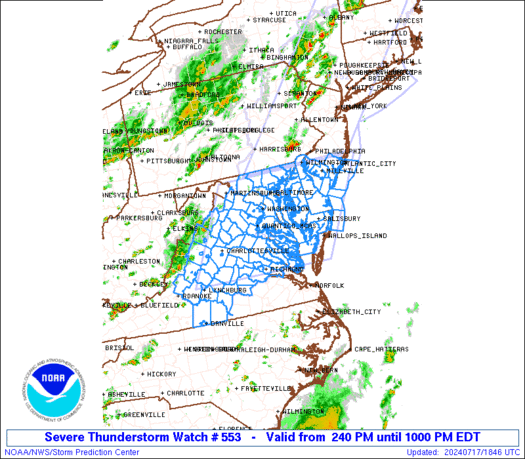
Severe Thunderstorm Watch Number 553
NWS Storm Prediction Center Norman OK
240 PM EDT Wed Jul 17 2024
The NWS Storm Prediction Center has issued a
* Severe Thunderstorm Watch for portions of
District Of Columbia
Delaware
Central and Eastern Maryland
Southern New Jersey
Central and Eastern Virginia
Eastern Panhandle of West Virginia
Coastal Waters
* Effective this Wednesday afternoon and evening from 240 PM
until 1000 PM EDT.
* Primary threats include...
Scattered damaging wind gusts to 70 mph possible
SUMMARY...Thunderstorms are intensifying over the mountains of
western Virginia. These storms will track eastward through the
afternoon, posing a risk of locally damaging wind gusts.
The severe thunderstorm watch area is approximately along and 110
statute miles east and west of a line from 45 miles northeast of
Baltimore MD to 10 miles southwest of Richmond VA. For a complete
depiction of the watch see the associated watch outline update
(WOUS64 KWNS WOU3).
PRECAUTIONARY/PREPAREDNESS ACTIONS...
REMEMBER...A Severe Thunderstorm Watch means conditions are
favorable for severe thunderstorms in and close to the watch area.
Persons in these areas should be on the lookout for threatening
weather conditions and listen for later statements and possible
warnings. Severe thunderstorms can and occasionally do produce
tornadoes.
&&
OTHER WATCH INFORMATION...CONTINUE...WW 552...
AVIATION...A few severe thunderstorms with hail surface and aloft to
1 inch. Extreme turbulence and surface wind gusts to 60 knots. A few
cumulonimbi with maximum tops to 500. Mean storm motion vector
27025.
...Hart

   SEL3

   URGENT - IMMEDIATE BROADCAST REQUESTED
   Severe Thunderstorm Watch Number 553
   NWS Storm Prediction Center Norman OK
   240 PM EDT Wed Jul 17 2024

   The NWS Storm Prediction Center has issued a

   * Severe Thunderstorm Watch for portions of
     District Of Columbia
     Delaware
     Central and Eastern Maryland
     Southern New Jersey
     Central and Eastern Virginia
     Eastern Panhandle of West Virginia
     Coastal Waters

   * Effective this Wednesday afternoon and evening from 240 PM
     until 1000 PM EDT.

   * Primary threats include...
     Scattered damaging wind gusts to 70 mph possible

   SUMMARY...Thunderstorms are intensifying over the mountains of
   western Virginia.  These storms will track eastward through the
   afternoon, posing a risk of locally damaging wind gusts.

   The severe thunderstorm watch area is approximately along and 110
   statute miles east and west of a line from 45 miles northeast of
   Baltimore MD to 10 miles southwest of Richmond VA. For a complete
   depiction of the watch see the associated watch outline update
   (WOUS64 KWNS WOU3).

   PRECAUTIONARY/PREPAREDNESS ACTIONS...

   REMEMBER...A Severe Thunderstorm Watch means conditions are
   favorable for severe thunderstorms in and close to the watch area.
   Persons in these areas should be on the lookout for threatening
   weather conditions and listen for later statements and possible
   warnings. Severe thunderstorms can and occasionally do produce
   tornadoes.

   &&

   OTHER WATCH INFORMATION...CONTINUE...WW 552...

   AVIATION...A few severe thunderstorms with hail surface and aloft to
   1 inch. Extreme turbulence and surface wind gusts to 60 knots. A few
   cumulonimbi with maximum tops to 500. Mean storm motion vector
   27025.

   ...Hart
 Note:
The Aviation Watch (SAW) product is an approximation to the watch area.
The actual watch is depicted by the shaded areas.
Note:
The Aviation Watch (SAW) product is an approximation to the watch area.
The actual watch is depicted by the shaded areas.
   SAW3
   WW 553 SEVERE TSTM DC DE MD NJ VA WV CW 171840Z - 180200Z
   AXIS..110 STATUTE MILES EAST AND WEST OF LINE..
   45NE BWI/BALTIMORE MD/ - 10SW RIC/RICHMOND VA/
   ..AVIATION COORDS.. 95NM E/W /43ENE EMI - 8SW RIC/
   HAIL SURFACE AND ALOFT..1 INCH. WIND GUSTS..60 KNOTS.
   MAX TOPS TO 500. MEAN STORM MOTION VECTOR 27025.

   LAT...LON 39627401 37387544 37387944 39627814

   THIS IS AN APPROXIMATION TO THE WATCH AREA.  FOR A
   COMPLETE DEPICTION OF THE WATCH SEE WOUS64 KWNS
   FOR WOU3.
Watch 553 Status Report Messages:
STATUS REPORT #3 ON WW 553

VALID 180005Z - 180200Z

SEVERE WEATHER THREAT CONTINUES RIGHT OF A LINE FROM 15 WSW LYH
TO 25 E LYH TO 30 SW RIC TO 20 NW ILG.

WW 553 WILL BE ALLOWED TO EXPIRE AT 180200Z.

FOR ADDITIONAL INFORMATION SEE MESOSCALE DISCUSSION 1675

..GLEASON..07/18/24

ATTN...WFO...LWX...PHI...AKQ...RNK...

&&

STATUS REPORT FOR WS 553

SEVERE WEATHER THREAT CONTINUES FOR THE FOLLOWING AREAS

DEC001-003-005-180200-

DE
.    DELAWARE COUNTIES INCLUDED ARE

KENT		     NEW CASTLE 	 SUSSEX
$$


MDC009-011-015-019-029-035-037-039-041-045-047-180200-

MD
.    MARYLAND COUNTIES INCLUDED ARE

CALVERT 	     CAROLINE		 CECIL
DORCHESTER	     KENT		 QUEEN ANNE'S
ST. MARYS	     SOMERSET		 TALBOT
WICOMICO	     WORCESTER
$$


NJC001-009-011-033-180200-

NJ
.    NEW JERSEY COUNTIES INCLUDED ARE

ATLANTIC	     CAPE MAY		 CUMBERLAND
SALEM
$$


VAC025-031-036-037-041-053-057-073-083-097-101-103-111-115-117-
119-127-133-135-143-147-149-159-193-570-590-670-730-180200-

VA
.    VIRGINIA COUNTIES INCLUDED ARE

BRUNSWICK	     CAMPBELL		 CHARLES CITY
CHARLOTTE	     CHESTERFIELD	 DINWIDDIE
ESSEX		     GLOUCESTER 	 HALIFAX
KING AND QUEEN	     KING WILLIAM	 LANCASTER
LUNENBURG	     MATHEWS		 MECKLENBURG
MIDDLESEX	     NEW KENT		 NORTHUMBERLAND
NOTTOWAY	     PITTSYLVANIA	 PRINCE EDWARD
PRINCE GEORGE	     RICHMOND		 WESTMORELAND


VIRGINIA INDEPENDENT CITIES INCLUDED ARE

COLONIAL HEIGHTS     DANVILLE		 HOPEWELL
PETERSBURG
$$


ANZ430-431-452-453-454-455-533-534-537-539-540-541-542-543-630-
635-650-180200-

CW

.    ADJACENT COASTAL WATERS INCLUDED ARE

DELAWARE BAY WATERS NORTH OF EAST POINT NJ TO SLAUGHTER BEACH DE

DELAWARE BAY WATERS SOUTH OF EAST POINT NJ TO SLAUGHTER BEACH DE

COASTAL WATERS FROM LITTLE EGG INLET TO GREAT EGG INLET NJ OUT 20
NM

COASTAL WATERS FROM GREAT EGG INLET TO CAPE MAY NJ OUT 20 NM

COASTAL WATERS FROM CAPE MAY NJ TO CAPE HENLOPEN DE OUT 20 NM

COASTAL WATERS FROM CAPE HENLOPEN TO FENWICK ISLAND DE OUT 20 NM

CHESAPEAKE BAY FROM NORTH BEACH TO DRUM POINT MD

CHESAPEAKE BAY FROM DRUM POINT MD TO SMITH POINT VA

TIDAL POTOMAC FROM COBB ISLAND MD TO SMITH POINT VA

CHESTER RIVER TO QUEENSTOWN MD

EASTERN BAY

CHOPTANK RIVER TO CAMBRIDGE MD AND THE LITTLE CHOPTANK RIVER

PATUXENT RIVER TO BROOMES ISLAND MD

TANGIER SOUND AND THE INLAND WATERS SURROUNDING BLOODSWORTH
ISLAND

CHESAPEAKE BAY FROM SMITH POINT TO WINDMILL POINT VA

RAPPAHANNOCK RIVER FROM URBANNA TO WINDMILL POINT

COASTAL WATERS FROM FENWICK ISLAND DE TO CHINCOTEAGUE VA OUT 20
NM

$$
THE WATCH STATUS MESSAGE IS FOR GUIDANCE PURPOSES ONLY.  PLEASE
REFER TO WATCH COUNTY NOTIFICATION STATEMENTS FOR OFFICIAL
INFORMATION ON COUNTIES...INDEPENDENT CITIES AND MARINE ZONES
CLEARED FROM SEVERE THUNDERSTORM AND TORNADO WATCHES.
$$

STATUS REPORT #2 ON WW 553

VALID 172200Z - 172340Z

SEVERE WEATHER THREAT CONTINUES RIGHT OF A LINE FROM 15 SW LYH TO
15 SE CHO TO 25 WNW DCA TO 25 W BWI TO 35 S CXY.

..HALBERT..07/17/24

ATTN...WFO...LWX...PHI...AKQ...RNK...

&&

STATUS REPORT FOR WS 553

SEVERE WEATHER THREAT CONTINUES FOR THE FOLLOWING AREAS

DEC001-003-005-172340-

DE
.    DELAWARE COUNTIES INCLUDED ARE

KENT		     NEW CASTLE 	 SUSSEX
$$


DCC001-172340-

DC
.    DISTRICT OF COLUMBIA COUNTIES INCLUDED ARE

DISTRICT OF COLUMBIA
$$


MDC003-005-009-011-015-017-019-025-027-029-033-035-037-039-041-
045-047-510-172340-

MD
.    MARYLAND COUNTIES INCLUDED ARE

ANNE ARUNDEL	     BALTIMORE		 CALVERT
CAROLINE	     CECIL		 CHARLES
DORCHESTER	     HARFORD		 HOWARD
KENT		     PRINCE GEORGES	 QUEEN ANNE'S
ST. MARYS	     SOMERSET		 TALBOT
WICOMICO	     WORCESTER


MARYLAND INDEPENDENT CITIES INCLUDED ARE

BALTIMORE CITY
$$


NJC001-009-011-033-172340-

NJ
.    NEW JERSEY COUNTIES INCLUDED ARE

ATLANTIC	     CAPE MAY		 CUMBERLAND
SALEM
$$


VAC007-011-013-025-029-031-033-036-037-041-049-053-057-059-065-
073-075-083-085-087-097-099-101-103-109-111-115-117-119-127-133-
135-137-143-145-147-149-153-159-177-179-193-510-570-590-600-610-
630-670-683-685-730-760-172340-

VA
.    VIRGINIA COUNTIES INCLUDED ARE

AMELIA		     APPOMATTOX 	 ARLINGTON
BRUNSWICK	     BUCKINGHAM 	 CAMPBELL
CAROLINE	     CHARLES CITY	 CHARLOTTE
CHESTERFIELD	     CUMBERLAND 	 DINWIDDIE
ESSEX		     FAIRFAX		 FLUVANNA
GLOUCESTER	     GOOCHLAND		 HALIFAX
HANOVER 	     HENRICO		 KING AND QUEEN
KING GEORGE	     KING WILLIAM	 LANCASTER
LOUISA		     LUNENBURG		 MATHEWS
MECKLENBURG	     MIDDLESEX		 NEW KENT
NORTHUMBERLAND	     NOTTOWAY		 ORANGE
PITTSYLVANIA	     POWHATAN		 PRINCE EDWARD
PRINCE GEORGE	     PRINCE WILLIAM	 RICHMOND
SPOTSYLVANIA	     STAFFORD		 WESTMORELAND


VIRGINIA INDEPENDENT CITIES INCLUDED ARE

ALEXANDRIA	     COLONIAL HEIGHTS	 DANVILLE
FAIRFAX 	     FALLS CHURCH	 FREDERICKSBURG
HOPEWELL	     MANASSAS		 MANASSAS PARK
PETERSBURG	     RICHMOND
$$


ANZ430-431-452-453-454-455-530-531-532-533-534-535-536-537-538-
539-540-541-542-543-630-635-650-172340-

CW

.    ADJACENT COASTAL WATERS INCLUDED ARE

DELAWARE BAY WATERS NORTH OF EAST POINT NJ TO SLAUGHTER BEACH DE

DELAWARE BAY WATERS SOUTH OF EAST POINT NJ TO SLAUGHTER BEACH DE

COASTAL WATERS FROM LITTLE EGG INLET TO GREAT EGG INLET NJ OUT 20
NM

COASTAL WATERS FROM GREAT EGG INLET TO CAPE MAY NJ OUT 20 NM

COASTAL WATERS FROM CAPE MAY NJ TO CAPE HENLOPEN DE OUT 20 NM

COASTAL WATERS FROM CAPE HENLOPEN TO FENWICK ISLAND DE OUT 20 NM

CHESAPEAKE BAY NORTH OF POOLES ISLAND MD

CHESAPEAKE BAY FROM POOLES ISLAND TO SANDY POINT MD

CHESAPEAKE BAY FROM SANDY POINT TO NORTH BEACH MD

CHESAPEAKE BAY FROM NORTH BEACH TO DRUM POINT MD

CHESAPEAKE BAY FROM DRUM POINT MD TO SMITH POINT VA

TIDAL POTOMAC FROM KEY BRIDGE TO INDIAN HEAD MD

TIDAL POTOMAC FROM INDIAN HEAD TO COBB ISLAND MD

TIDAL POTOMAC FROM COBB ISLAND MD TO SMITH POINT VA

PATAPSCO RIVER INCLUDING BALTIMORE HARBOR

CHESTER RIVER TO QUEENSTOWN MD

EASTERN BAY

CHOPTANK RIVER TO CAMBRIDGE MD AND THE LITTLE CHOPTANK RIVER

PATUXENT RIVER TO BROOMES ISLAND MD

TANGIER SOUND AND THE INLAND WATERS SURROUNDING BLOODSWORTH
ISLAND

CHESAPEAKE BAY FROM SMITH POINT TO WINDMILL POINT VA

RAPPAHANNOCK RIVER FROM URBANNA TO WINDMILL POINT

COASTAL WATERS FROM FENWICK ISLAND DE TO CHINCOTEAGUE VA OUT 20
NM

$$
THE WATCH STATUS MESSAGE IS FOR GUIDANCE PURPOSES ONLY.  PLEASE
REFER TO WATCH COUNTY NOTIFICATION STATEMENTS FOR OFFICIAL
INFORMATION ON COUNTIES...INDEPENDENT CITIES AND MARINE ZONES
CLEARED FROM SEVERE THUNDERSTORM AND TORNADO WATCHES.
$$

STATUS REPORT #1 ON WW 553

VALID 172010Z - 172140Z

THE SEVERE WEATHER THREAT CONTINUES ACROSS THE ENTIRE WATCH AREA.

..HALBERT..07/17/24

ATTN...WFO...LWX...PHI...AKQ...RNK...

&&

STATUS REPORT FOR WS 553

SEVERE WEATHER THREAT CONTINUES FOR THE FOLLOWING AREAS

DEC001-003-005-172140-

DE
.    DELAWARE COUNTIES INCLUDED ARE

KENT		     NEW CASTLE 	 SUSSEX
$$


DCC001-172140-

DC
.    DISTRICT OF COLUMBIA COUNTIES INCLUDED ARE

DISTRICT OF COLUMBIA
$$


MDC003-005-009-011-013-015-017-019-021-025-027-029-031-033-035-
037-039-041-045-047-510-172140-

MD
.    MARYLAND COUNTIES INCLUDED ARE

ANNE ARUNDEL	     BALTIMORE		 CALVERT
CAROLINE	     CARROLL		 CECIL
CHARLES 	     DORCHESTER 	 FREDERICK
HARFORD 	     HOWARD		 KENT
MONTGOMERY	     PRINCE GEORGES	 QUEEN ANNE'S
ST. MARYS	     SOMERSET		 TALBOT
WICOMICO	     WORCESTER


MARYLAND INDEPENDENT CITIES INCLUDED ARE

BALTIMORE CITY
$$


NJC001-009-011-033-172140-

NJ
.    NEW JERSEY COUNTIES INCLUDED ARE

ATLANTIC	     CAPE MAY		 CUMBERLAND
SALEM
$$


VAC003-007-009-011-013-015-019-023-029-031-033-036-037-041-043-
047-049-057-059-061-065-073-075-079-083-085-087-097-099-101-103-
107-109-113-115-119-125-127-133-135-137-139-143-145-147-153-157-
159-163-165-171-177-179-187-193-510-530-540-590-600-610-630-660-
678-680-683-685-760-790-820-172140-

VA
.    VIRGINIA COUNTIES INCLUDED ARE

ALBEMARLE	     AMELIA		 AMHERST
APPOMATTOX	     ARLINGTON		 AUGUSTA
BEDFORD 	     BOTETOURT		 BUCKINGHAM
CAMPBELL	     CAROLINE		 CHARLES CITY
CHARLOTTE	     CHESTERFIELD	 CLARKE
CULPEPER	     CUMBERLAND 	 ESSEX
FAIRFAX 	     FAUQUIER		 FLUVANNA
GLOUCESTER	     GOOCHLAND		 GREENE
HALIFAX 	     HANOVER		 HENRICO
KING AND QUEEN	     KING GEORGE	 KING WILLIAM
LANCASTER	     LOUDOUN		 LOUISA
MADISON 	     MATHEWS		 MIDDLESEX
NELSON		     NEW KENT		 NORTHUMBERLAND
NOTTOWAY	     ORANGE		 PAGE
PITTSYLVANIA	     POWHATAN		 PRINCE EDWARD
PRINCE WILLIAM	     RAPPAHANNOCK	 RICHMOND
ROCKBRIDGE	     ROCKINGHAM 	 SHENANDOAH
SPOTSYLVANIA	     STAFFORD		 WARREN
WESTMORELAND


VIRGINIA INDEPENDENT CITIES INCLUDED ARE

ALEXANDRIA	     BUENA VISTA	 CHARLOTTESVILLE
DANVILLE	     FAIRFAX		 FALLS CHURCH
FREDERICKSBURG	     HARRISONBURG	 LEXINGTON
LYNCHBURG	     MANASSAS		 MANASSAS PARK
RICHMOND	     STAUNTON		 WAYNESBORO
$$


WVC037-172140-

WV
.    WEST VIRGINIA COUNTIES INCLUDED ARE

JEFFERSON
$$


ANZ430-431-452-453-454-455-530-531-532-533-534-535-536-537-538-
539-540-541-542-543-630-635-650-172140-

CW

.    ADJACENT COASTAL WATERS INCLUDED ARE

DELAWARE BAY WATERS NORTH OF EAST POINT NJ TO SLAUGHTER BEACH DE

DELAWARE BAY WATERS SOUTH OF EAST POINT NJ TO SLAUGHTER BEACH DE

COASTAL WATERS FROM LITTLE EGG INLET TO GREAT EGG INLET NJ OUT 20
NM

COASTAL WATERS FROM GREAT EGG INLET TO CAPE MAY NJ OUT 20 NM

COASTAL WATERS FROM CAPE MAY NJ TO CAPE HENLOPEN DE OUT 20 NM

COASTAL WATERS FROM CAPE HENLOPEN TO FENWICK ISLAND DE OUT 20 NM

CHESAPEAKE BAY NORTH OF POOLES ISLAND MD

CHESAPEAKE BAY FROM POOLES ISLAND TO SANDY POINT MD

CHESAPEAKE BAY FROM SANDY POINT TO NORTH BEACH MD

CHESAPEAKE BAY FROM NORTH BEACH TO DRUM POINT MD

CHESAPEAKE BAY FROM DRUM POINT MD TO SMITH POINT VA

TIDAL POTOMAC FROM KEY BRIDGE TO INDIAN HEAD MD

TIDAL POTOMAC FROM INDIAN HEAD TO COBB ISLAND MD

TIDAL POTOMAC FROM COBB ISLAND MD TO SMITH POINT VA

PATAPSCO RIVER INCLUDING BALTIMORE HARBOR

CHESTER RIVER TO QUEENSTOWN MD

EASTERN BAY

CHOPTANK RIVER TO CAMBRIDGE MD AND THE LITTLE CHOPTANK RIVER

PATUXENT RIVER TO BROOMES ISLAND MD

TANGIER SOUND AND THE INLAND WATERS SURROUNDING BLOODSWORTH
ISLAND

CHESAPEAKE BAY FROM SMITH POINT TO WINDMILL POINT VA

RAPPAHANNOCK RIVER FROM URBANNA TO WINDMILL POINT

COASTAL WATERS FROM FENWICK ISLAND DE TO CHINCOTEAGUE VA OUT 20
NM

$$
THE WATCH STATUS MESSAGE IS FOR GUIDANCE PURPOSES ONLY.  PLEASE
REFER TO WATCH COUNTY NOTIFICATION STATEMENTS FOR OFFICIAL
INFORMATION ON COUNTIES...INDEPENDENT CITIES AND MARINE ZONES
CLEARED FROM SEVERE THUNDERSTORM AND TORNADO WATCHES.
$$
Note:
Click for Complete Product Text.
Tornadoes
Probability of 2 or more tornadoes
|
Low (<5%)
|
Probability of 1 or more strong (EF2-EF5) tornadoes
|
Low (<2%)
|
Wind
Probability of 10 or more severe wind events
|
Mod (50%)
|
Probability of 1 or more wind events > 65 knots
|
Low (20%)
|
Hail
Probability of 10 or more severe hail events
|
Low (10%)
|
Probability of 1 or more hailstones > 2 inches
|
Low (<5%)
|
Combined Severe Hail/Wind
Probability of 6 or more combined severe hail/wind events
|
Mod (60%)
|
For each watch, probabilities for particular events inside the watch
(listed above in each table) are determined by the issuing forecaster.
The "Low" category contains probability values ranging from less than 2%
to 20% (EF2-EF5 tornadoes), less than 5% to 20% (all other probabilities),
"Moderate" from 30% to 60%, and "High" from 70% to greater than 95%.
High values are bolded and lighter in color to provide awareness of
an increased threat for a particular event.


 @NWSSPC


