Note:
The expiration time in the watch graphic is amended if the watch is
replaced, cancelled or extended.
Note:
Note:
The expiration time in the watch graphic is amended if the watch is
replaced, cancelled or extended.
Note: Click for
Watch Status Reports.
SEL8
URGENT - IMMEDIATE BROADCAST REQUESTED
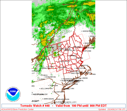
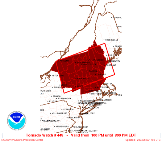
Tornado Watch Number 448
NWS Storm Prediction Center Norman OK
100 PM EDT Sun Jun 23 2024
The NWS Storm Prediction Center has issued a
* Tornado Watch for portions of
Massachusetts
Western Maine
New Hampshire
Northeast New York
Vermont
* Effective this Sunday afternoon and evening from 100 PM until
800 PM EDT.
* Primary threats include...
A few tornadoes likely
Scattered damaging wind gusts to 70 mph likely
Scattered large hail events to 1.5 inches in diameter possible
SUMMARY...Thunderstorms will develop this afternoon across eastern
New York and track eastward across the watch area through the day.
Supercells capable of damaging winds, hail, and a few tornadoes are
expected.
The tornado watch area is approximately along and 85 statute miles
north and south of a line from 65 miles southwest of Saranac Lake NY
to 25 miles south southeast of Augusta ME. For a complete depiction
of the watch see the associated watch outline update (WOUS64 KWNS
WOU8).
PRECAUTIONARY/PREPAREDNESS ACTIONS...
REMEMBER...A Tornado Watch means conditions are favorable for
tornadoes and severe thunderstorms in and close to the watch
area. Persons in these areas should be on the lookout for
threatening weather conditions and listen for later statements
and possible warnings.
&&
AVIATION...Tornadoes and a few severe thunderstorms with hail
surface and aloft to 1.5 inches. Extreme turbulence and surface wind
gusts to 60 knots. A few cumulonimbi with maximum tops to 500. Mean
storm motion vector 26030.
...Hart
   SEL8

   URGENT - IMMEDIATE BROADCAST REQUESTED
   Tornado Watch Number 448
   NWS Storm Prediction Center Norman OK
   100 PM EDT Sun Jun 23 2024

   The NWS Storm Prediction Center has issued a

   * Tornado Watch for portions of
     Massachusetts
     Western Maine
     New Hampshire
     Northeast New York
     Vermont

   * Effective this Sunday afternoon and evening from 100 PM until
     800 PM EDT.

   * Primary threats include...
     A few tornadoes likely
     Scattered damaging wind gusts to 70 mph likely
     Scattered large hail events to 1.5 inches in diameter possible

   SUMMARY...Thunderstorms will develop this afternoon across eastern
   New York and track eastward across the watch area through the day.
   Supercells capable of damaging winds, hail, and a few tornadoes are
   expected.

   The tornado watch area is approximately along and 85 statute miles
   north and south of a line from 65 miles southwest of Saranac Lake NY
   to 25 miles south southeast of Augusta ME. For a complete depiction
   of the watch see the associated watch outline update (WOUS64 KWNS
   WOU8).

   PRECAUTIONARY/PREPAREDNESS ACTIONS...

   REMEMBER...A Tornado Watch means conditions are favorable for
   tornadoes and severe thunderstorms in and close to the watch
   area. Persons in these areas should be on the lookout for
   threatening weather conditions and listen for later statements
   and possible warnings.

   &&

   AVIATION...Tornadoes and a few severe thunderstorms with hail
   surface and aloft to 1.5 inches. Extreme turbulence and surface wind
   gusts to 60 knots. A few cumulonimbi with maximum tops to 500. Mean
   storm motion vector 26030.

   ...Hart
 Note:
The Aviation Watch (SAW) product is an approximation to the watch area.
The actual watch is depicted by the shaded areas.
Note:
The Aviation Watch (SAW) product is an approximation to the watch area.
The actual watch is depicted by the shaded areas.
   SAW8
   WW 448 TORNADO MA ME NH NY VT 231700Z - 240000Z
   AXIS..85 STATUTE MILES NORTH AND SOUTH OF LINE..
   65SW SLK/SARANAC LAKE NY/ - 25SSE AUG/AUGUSTA ME/
   ..AVIATION COORDS.. 75NM N/S /58NE SYR - 55NE ENE/
   HAIL SURFACE AND ALOFT..1.5 INCHES. WIND GUSTS..60 KNOTS.
   MAX TOPS TO 500. MEAN STORM MOTION VECTOR 26030.

   LAT...LON 44947512 45226961 42766961 42487512

   THIS IS AN APPROXIMATION TO THE WATCH AREA.  FOR A
   COMPLETE DEPICTION OF THE WATCH SEE WOUS64 KWNS
   FOR WOU8.
Watch 448 Status Report Messages:
STATUS REPORT #2 ON WW 448

VALID 232235Z - 232340Z

SEVERE WEATHER THREAT CONTINUES RIGHT OF A LINE FROM 40 WSW ALB
TO 20 NNE GFL TO 65 NNW BTV.

FOR ADDITIONAL INFORMATION SEE MESOSCALE DISCUSSION 1387

..WENDT..06/23/24

ATTN...WFO...ALY...BOX...GYX...BTV...

&&

STATUS REPORT FOR WT 448

SEVERE WEATHER THREAT CONTINUES FOR THE FOLLOWING AREAS

CTC003-013-015-232340-

CT
.    CONNECTICUT COUNTIES INCLUDED ARE

HARTFORD	     TOLLAND		 WINDHAM
$$


MEC001-005-007-017-031-232340-

ME
.    MAINE COUNTIES INCLUDED ARE

ANDROSCOGGIN	     CUMBERLAND 	 FRANKLIN
OXFORD		     YORK
$$


MAC003-009-011-013-015-017-021-025-027-232340-

MA
.    MASSACHUSETTS COUNTIES INCLUDED ARE

BERKSHIRE	     ESSEX		 FRANKLIN
HAMPDEN 	     HAMPSHIRE		 MIDDLESEX
NORFOLK 	     SUFFOLK		 WORCESTER
$$


NHC001-003-005-007-009-011-013-015-017-019-232340-

NH
.    NEW HAMPSHIRE COUNTIES INCLUDED ARE

BELKNAP 	     CARROLL		 CHESHIRE
COOS		     GRAFTON		 HILLSBOROUGH
MERRIMACK	     ROCKINGHAM 	 STRAFFORD
SULLIVAN
$$


NYC001-083-091-093-115-232340-

NY
.    NEW YORK COUNTIES INCLUDED ARE

ALBANY		     RENSSELAER 	 SARATOGA
SCHENECTADY	     WASHINGTON
$$


RIC007-232340-

RI
.    RHODE ISLAND COUNTIES INCLUDED ARE

PROVIDENCE
$$


VTC001-003-005-007-009-011-013-015-017-019-021-023-025-027-
232340-

VT
.    VERMONT COUNTIES INCLUDED ARE

ADDISON 	     BENNINGTON 	 CALEDONIA
CHITTENDEN	     ESSEX		 FRANKLIN
GRAND ISLE	     LAMOILLE		 ORANGE
ORLEANS 	     RUTLAND		 WASHINGTON
WINDHAM 	     WINDSOR
$$


ANZ230-232340-

CW

.    ADJACENT COASTAL WATERS INCLUDED ARE

ANZ230

$$
THE WATCH STATUS MESSAGE IS FOR GUIDANCE PURPOSES ONLY.  PLEASE
REFER TO WATCH COUNTY NOTIFICATION STATEMENTS FOR OFFICIAL
INFORMATION ON COUNTIES...INDEPENDENT CITIES AND MARINE ZONES
CLEARED FROM SEVERE THUNDERSTORM AND TORNADO WATCHES.
$$

STATUS REPORT #1 ON WW 448

VALID 232030Z - 232140Z

THE SEVERE WEATHER THREAT CONTINUES ACROSS THE ENTIRE WATCH AREA.

..BENTLEY..06/23/24

ATTN...WFO...ALY...BOX...GYX...BTV...

&&

STATUS REPORT FOR WT 448

SEVERE WEATHER THREAT CONTINUES FOR THE FOLLOWING AREAS

MEC001-005-007-017-031-232140-

ME
.    MAINE COUNTIES INCLUDED ARE

ANDROSCOGGIN	     CUMBERLAND 	 FRANKLIN
OXFORD		     YORK
$$


MAC003-009-011-013-015-017-027-232140-

MA
.    MASSACHUSETTS COUNTIES INCLUDED ARE

BERKSHIRE	     ESSEX		 FRANKLIN
HAMPDEN 	     HAMPSHIRE		 MIDDLESEX
WORCESTER
$$


NHC001-003-005-007-009-011-013-015-017-019-232140-

NH
.    NEW HAMPSHIRE COUNTIES INCLUDED ARE

BELKNAP 	     CARROLL		 CHESHIRE
COOS		     GRAFTON		 HILLSBOROUGH
MERRIMACK	     ROCKINGHAM 	 STRAFFORD
SULLIVAN
$$


NYC001-019-031-033-035-041-043-057-083-089-091-093-113-115-
232140-

NY
.    NEW YORK COUNTIES INCLUDED ARE

ALBANY		     CLINTON		 ESSEX
FRANKLIN	     FULTON		 HAMILTON
HERKIMER	     MONTGOMERY 	 RENSSELAER
ST. LAWRENCE	     SARATOGA		 SCHENECTADY
WARREN		     WASHINGTON
$$


VTC001-003-005-007-009-011-013-015-017-019-021-023-025-027-
232140-

VT
.    VERMONT COUNTIES INCLUDED ARE

ADDISON 	     BENNINGTON 	 CALEDONIA
CHITTENDEN	     ESSEX		 FRANKLIN
GRAND ISLE	     LAMOILLE		 ORANGE
ORLEANS 	     RUTLAND		 WASHINGTON
WINDHAM 	     WINDSOR
$$


THE WATCH STATUS MESSAGE IS FOR GUIDANCE PURPOSES ONLY.  PLEASE
REFER TO WATCH COUNTY NOTIFICATION STATEMENTS FOR OFFICIAL
INFORMATION ON COUNTIES...INDEPENDENT CITIES AND MARINE ZONES
CLEARED FROM SEVERE THUNDERSTORM AND TORNADO WATCHES.
$$
Note:
Click for Complete Product Text.
Tornadoes
Probability of 2 or more tornadoes
|
Mod (60%)
|
Probability of 1 or more strong (EF2-EF5) tornadoes
|
Low (20%)
|
Wind
Probability of 10 or more severe wind events
|
Mod (60%)
|
Probability of 1 or more wind events > 65 knots
|
Low (20%)
|
Hail
Probability of 10 or more severe hail events
|
Mod (40%)
|
Probability of 1 or more hailstones > 2 inches
|
Low (20%)
|
Combined Severe Hail/Wind
Probability of 6 or more combined severe hail/wind events
|
High (90%)
|
For each watch, probabilities for particular events inside the watch
(listed above in each table) are determined by the issuing forecaster.
The "Low" category contains probability values ranging from less than 2%
to 20% (EF2-EF5 tornadoes), less than 5% to 20% (all other probabilities),
"Moderate" from 30% to 60%, and "High" from 70% to greater than 95%.
High values are bolded and lighter in color to provide awareness of
an increased threat for a particular event.


 @NWSSPC