 Note:
The expiration time in the watch graphic is amended if the watch is
replaced, cancelled or extended.
Note:
Note:
The expiration time in the watch graphic is amended if the watch is
replaced, cancelled or extended.
Note: Click for
Watch Status Reports.
SEL3
URGENT - IMMEDIATE BROADCAST REQUESTED
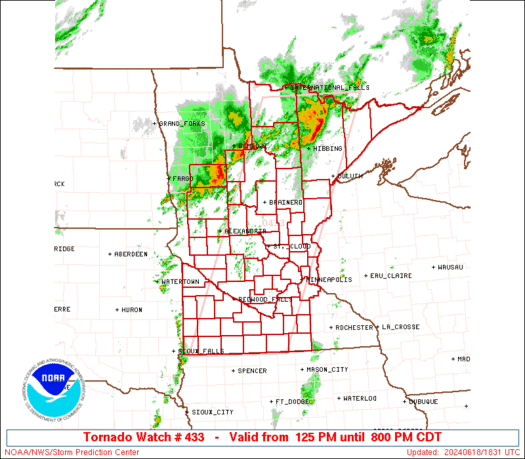
Tornado Watch Number 433
NWS Storm Prediction Center Norman OK
125 PM CDT Tue Jun 18 2024
The NWS Storm Prediction Center has issued a
* Tornado Watch for portions of
Minnesota
* Effective this Tuesday afternoon and evening from 125 PM until
800 PM CDT.
* Primary threats include...
A few tornadoes possible
Scattered damaging wind gusts to 70 mph likely
Scattered large hail and isolated very large hail events to 2
inches in diameter possible
SUMMARY...Thunderstorms developing along and ahead of a cold front
should pose a threat for a few tornadoes, damaging winds up to 60-70
mph, and large hail around 1-2 inches in diameter as they spread
east-northeastward this afternoon and early evening.
The tornado watch area is approximately along and 65 statute miles
east and west of a line from 50 miles northwest of Ely MN to 30
miles east southeast of Worthington MN. For a complete depiction of
the watch see the associated watch outline update (WOUS64 KWNS
WOU3).
PRECAUTIONARY/PREPAREDNESS ACTIONS...
REMEMBER...A Tornado Watch means conditions are favorable for
tornadoes and severe thunderstorms in and close to the watch
area. Persons in these areas should be on the lookout for
threatening weather conditions and listen for later statements
and possible warnings.
&&
AVIATION...Tornadoes and a few severe thunderstorms with hail
surface and aloft to 2 inches. Extreme turbulence and surface wind
gusts to 60 knots. A few cumulonimbi with maximum tops to 550. Mean
storm motion vector 25035.
...Gleason
   SEL3

   URGENT - IMMEDIATE BROADCAST REQUESTED
   Tornado Watch Number 433
   NWS Storm Prediction Center Norman OK
   125 PM CDT Tue Jun 18 2024

   The NWS Storm Prediction Center has issued a

   * Tornado Watch for portions of
     Minnesota

   * Effective this Tuesday afternoon and evening from 125 PM until
     800 PM CDT.

   * Primary threats include...
     A few tornadoes possible
     Scattered damaging wind gusts to 70 mph likely
     Scattered large hail and isolated very large hail events to 2
       inches in diameter possible

   SUMMARY...Thunderstorms developing along and ahead of a cold front
   should pose a threat for a few tornadoes, damaging winds up to 60-70
   mph, and large hail around 1-2 inches in diameter as they spread
   east-northeastward this afternoon and early evening.

   The tornado watch area is approximately along and 65 statute miles
   east and west of a line from 50 miles northwest of Ely MN to 30
   miles east southeast of Worthington MN. For a complete depiction of
   the watch see the associated watch outline update (WOUS64 KWNS
   WOU3).

   PRECAUTIONARY/PREPAREDNESS ACTIONS...

   REMEMBER...A Tornado Watch means conditions are favorable for
   tornadoes and severe thunderstorms in and close to the watch
   area. Persons in these areas should be on the lookout for
   threatening weather conditions and listen for later statements
   and possible warnings.

   &&

   AVIATION...Tornadoes and a few severe thunderstorms with hail
   surface and aloft to 2 inches. Extreme turbulence and surface wind
   gusts to 60 knots. A few cumulonimbi with maximum tops to 550. Mean
   storm motion vector 25035.

   ...Gleason
 Note:
The Aviation Watch (SAW) product is an approximation to the watch area.
The actual watch is depicted by the shaded areas.
Note:
The Aviation Watch (SAW) product is an approximation to the watch area.
The actual watch is depicted by the shaded areas.
   SAW3
   WW 433 TORNADO MN 181825Z - 190100Z
   AXIS..65 STATUTE MILES EAST AND WEST OF LINE..
   50NW ELO/ELY MN/ - 30ESE OTG/WORTHINGTON MN/
   ..AVIATION COORDS.. 55NM E/W /32ESE INL - 59S RWF/
   HAIL SURFACE AND ALOFT..2 INCHES. WIND GUSTS..60 KNOTS.
   MAX TOPS TO 550. MEAN STORM MOTION VECTOR 25035.

   LAT...LON 48409122 43489373 43489632 48409406

   THIS IS AN APPROXIMATION TO THE WATCH AREA.  FOR A
   COMPLETE DEPICTION OF THE WATCH SEE WOUS64 KWNS
   FOR WOU3.
Watch 433 Status Report Messages:
STATUS REPORT #6 ON WW 433

VALID 190035Z - 190140Z

SEVERE WEATHER THREAT CONTINUES RIGHT OF A LINE FROM 25 SW OTG TO
20 E RWF TO 15 NE STC TO 40 W DLH TO 20 NNW BFW.

FOR ADDITIONAL INFORMATION SEE MESOSCALE DISCUSSION 1329

..THORNTON..06/19/24

ATTN...WFO...DLH...MPX...FGF...FSD...

&&

STATUS REPORT FOR WT 433

SEVERE WEATHER THREAT CONTINUES FOR THE FOLLOWING AREAS

MNC003-013-015-017-019-025-033-037-043-047-053-059-063-065-079-
085-091-095-103-115-123-131-139-141-143-147-161-163-165-171-
190140-

MN
.    MINNESOTA COUNTIES INCLUDED ARE

ANOKA		     BLUE EARTH 	 BROWN
CARLTON 	     CARVER		 CHISAGO
COTTONWOOD	     DAKOTA		 FARIBAULT
FREEBORN	     HENNEPIN		 ISANTI
JACKSON 	     KANABEC		 LE SUEUR
MCLEOD		     MARTIN		 MILLE LACS
NICOLLET	     PINE		 RAMSEY
RICE		     SCOTT		 SHERBURNE
SIBLEY		     STEELE		 WASECA
WASHINGTON	     WATONWAN		 WRIGHT
$$


THE WATCH STATUS MESSAGE IS FOR GUIDANCE PURPOSES ONLY.  PLEASE
REFER TO WATCH COUNTY NOTIFICATION STATEMENTS FOR OFFICIAL
INFORMATION ON COUNTIES...INDEPENDENT CITIES AND MARINE ZONES
CLEARED FROM SEVERE THUNDERSTORM AND TORNADO WATCHES.
$$

STATUS REPORT #5 ON WW 433

VALID 190005Z - 190140Z

SEVERE WEATHER THREAT CONTINUES RIGHT OF A LINE FROM 25 SSW FSD
TO 25 ENE RWF TO 25 SSW BRD TO 30 N BFW.

FOR ADDITIONAL INFORMATION SEE MESOSCALE DISCUSSION 1329

..THORNTON..06/19/24

ATTN...WFO...DLH...MPX...FGF...FSD...

&&

STATUS REPORT FOR WT 433

SEVERE WEATHER THREAT CONTINUES FOR THE FOLLOWING AREAS

MNC001-003-009-013-015-017-019-025-031-033-037-043-047-053-059-
063-065-079-085-091-093-095-103-115-123-131-139-141-143-147-161-
163-165-171-190140-

MN
.    MINNESOTA COUNTIES INCLUDED ARE

AITKIN		     ANOKA		 BENTON
BLUE EARTH	     BROWN		 CARLTON
CARVER		     CHISAGO		 COOK
COTTONWOOD	     DAKOTA		 FARIBAULT
FREEBORN	     HENNEPIN		 ISANTI
JACKSON 	     KANABEC		 LE SUEUR
MCLEOD		     MARTIN		 MEEKER
MILLE LACS	     NICOLLET		 PINE
RAMSEY		     RICE		 SCOTT
SHERBURNE	     SIBLEY		 STEELE
WASECA		     WASHINGTON 	 WATONWAN
WRIGHT
$$


THE WATCH STATUS MESSAGE IS FOR GUIDANCE PURPOSES ONLY.  PLEASE
REFER TO WATCH COUNTY NOTIFICATION STATEMENTS FOR OFFICIAL
INFORMATION ON COUNTIES...INDEPENDENT CITIES AND MARINE ZONES
CLEARED FROM SEVERE THUNDERSTORM AND TORNADO WATCHES.
$$

STATUS REPORT #4 ON WW 433

VALID 182235Z - 182340Z

SEVERE WEATHER THREAT CONTINUES RIGHT OF A LINE FROM 30 SE BKX TO
20 ENE AXN TO 25 W BRD TO 50 NNE ELO.

..THORNTON..06/18/24

ATTN...WFO...DLH...MPX...FGF...FSD...

&&

STATUS REPORT FOR WT 433

SEVERE WEATHER THREAT CONTINUES FOR THE FOLLOWING AREAS

MNC001-003-009-013-015-017-019-023-025-031-033-035-037-043-047-
053-059-063-065-067-075-079-083-085-091-093-095-097-101-103-105-
115-123-127-129-131-137-139-141-143-145-147-153-161-163-165-171-
173-182340-

MN
.    MINNESOTA COUNTIES INCLUDED ARE

AITKIN		     ANOKA		 BENTON
BLUE EARTH	     BROWN		 CARLTON
CARVER		     CHIPPEWA		 CHISAGO
COOK		     COTTONWOOD 	 CROW WING
DAKOTA		     FARIBAULT		 FREEBORN
HENNEPIN	     ISANTI		 JACKSON
KANABEC 	     KANDIYOHI		 LAKE
LE SUEUR	     LYON		 MCLEOD
MARTIN		     MEEKER		 MILLE LACS
MORRISON	     MURRAY		 NICOLLET
NOBLES		     PINE		 RAMSEY
REDWOOD 	     RENVILLE		 RICE
ST. LOUIS	     SCOTT		 SHERBURNE
SIBLEY		     STEARNS		 STEELE
TODD		     WASECA		 WASHINGTON
WATONWAN	     WRIGHT		 YELLOW MEDICINE
$$


THE WATCH STATUS MESSAGE IS FOR GUIDANCE PURPOSES ONLY.  PLEASE
REFER TO WATCH COUNTY NOTIFICATION STATEMENTS FOR OFFICIAL
INFORMATION ON COUNTIES...INDEPENDENT CITIES AND MARINE ZONES
CLEARED FROM SEVERE THUNDERSTORM AND TORNADO WATCHES.
$$

STATUS REPORT #3 ON WW 433

VALID 182135Z - 182240Z

SEVERE WEATHER THREAT CONTINUES RIGHT OF A LINE FROM 30 NNE BKX
TO 25 NE AXN TO 45 NNE ELO.

FOR ADDITIONAL INFORMATION SEE MESOSCALE DISCUSSION 1322

..THORNTON..06/18/24

ATTN...WFO...DLH...MPX...FGF...FSD...

&&

STATUS REPORT FOR WT 433

SEVERE WEATHER THREAT CONTINUES FOR THE FOLLOWING AREAS

MNC001-003-009-013-015-017-019-023-025-031-033-035-037-043-047-
053-059-063-065-067-075-079-081-083-085-091-093-095-097-101-103-
105-111-115-117-121-123-127-129-131-133-137-139-141-143-145-147-
151-153-161-163-165-171-173-182240-

MN
.    MINNESOTA COUNTIES INCLUDED ARE

AITKIN		     ANOKA		 BENTON
BLUE EARTH	     BROWN		 CARLTON
CARVER		     CHIPPEWA		 CHISAGO
COOK		     COTTONWOOD 	 CROW WING
DAKOTA		     FARIBAULT		 FREEBORN
HENNEPIN	     ISANTI		 JACKSON
KANABEC 	     KANDIYOHI		 LAKE
LE SUEUR	     LINCOLN		 LYON
MCLEOD		     MARTIN		 MEEKER
MILLE LACS	     MORRISON		 MURRAY
NICOLLET	     NOBLES		 OTTER TAIL
PINE		     PIPESTONE		 POPE
RAMSEY		     REDWOOD		 RENVILLE
RICE		     ROCK		 ST. LOUIS
SCOTT		     SHERBURNE		 SIBLEY
STEARNS 	     STEELE		 SWIFT
TODD		     WASECA		 WASHINGTON
WATONWAN	     WRIGHT		 YELLOW MEDICINE
$$


THE WATCH STATUS MESSAGE IS FOR GUIDANCE PURPOSES ONLY.  PLEASE
REFER TO WATCH COUNTY NOTIFICATION STATEMENTS FOR OFFICIAL
INFORMATION ON COUNTIES...INDEPENDENT CITIES AND MARINE ZONES
CLEARED FROM SEVERE THUNDERSTORM AND TORNADO WATCHES.
$$

STATUS REPORT #2 ON WW 433

VALID 182035Z - 182140Z

SEVERE WEATHER THREAT CONTINUES RIGHT OF A LINE FROM 15 NW VVV TO
40 WNW BRD TO 45 WNW HIB TO 45 NNE ELO.

FOR ADDITIONAL INFORMATION SEE MESOSCALE DISCUSSION 1322

..LYONS..06/18/24

ATTN...WFO...DLH...MPX...FGF...FSD...

&&

STATUS REPORT FOR WT 433

SEVERE WEATHER THREAT CONTINUES FOR THE FOLLOWING AREAS

MNC001-003-009-013-015-017-019-021-023-025-031-033-035-037-041-
043-047-053-059-061-063-065-067-073-075-079-081-083-085-091-093-
095-097-101-103-105-115-117-121-123-127-129-131-133-137-139-141-
143-145-147-149-151-153-159-161-163-165-171-173-182140-

MN
.    MINNESOTA COUNTIES INCLUDED ARE

AITKIN		     ANOKA		 BENTON
BLUE EARTH	     BROWN		 CARLTON
CARVER		     CASS		 CHIPPEWA
CHISAGO 	     COOK		 COTTONWOOD
CROW WING	     DAKOTA		 DOUGLAS
FARIBAULT	     FREEBORN		 HENNEPIN
ISANTI		     ITASCA		 JACKSON
KANABEC 	     KANDIYOHI		 LAC QUI PARLE
LAKE		     LE SUEUR		 LINCOLN
LYON		     MCLEOD		 MARTIN
MEEKER		     MILLE LACS 	 MORRISON
MURRAY		     NICOLLET		 NOBLES
PINE		     PIPESTONE		 POPE
RAMSEY		     REDWOOD		 RENVILLE
RICE		     ROCK		 ST. LOUIS
SCOTT		     SHERBURNE		 SIBLEY
STEARNS 	     STEELE		 STEVENS
SWIFT		     TODD		 WADENA
WASECA		     WASHINGTON 	 WATONWAN
WRIGHT		     YELLOW MEDICINE
$$


THE WATCH STATUS MESSAGE IS FOR GUIDANCE PURPOSES ONLY.  PLEASE
REFER TO WATCH COUNTY NOTIFICATION STATEMENTS FOR OFFICIAL
INFORMATION ON COUNTIES...INDEPENDENT CITIES AND MARINE ZONES
CLEARED FROM SEVERE THUNDERSTORM AND TORNADO WATCHES.
$$

STATUS REPORT #1 ON WW 433

VALID 181930Z - 182040Z

THE SEVERE WEATHER THREAT CONTINUES ACROSS THE ENTIRE WATCH AREA.

..GRAMS..06/18/24

ATTN...WFO...DLH...MPX...FGF...FSD...

&&

STATUS REPORT FOR WT 433

SEVERE WEATHER THREAT CONTINUES FOR THE FOLLOWING AREAS

MNC001-003-005-009-013-015-017-019-021-023-025-031-033-035-037-
041-043-047-051-053-057-059-061-063-065-067-071-073-075-079-081-
083-085-091-093-095-097-101-103-105-111-115-117-121-123-127-129-
131-133-137-139-141-143-145-147-149-151-153-159-161-163-165-171-
173-182040-

MN
.    MINNESOTA COUNTIES INCLUDED ARE

AITKIN		     ANOKA		 BECKER
BENTON		     BLUE EARTH 	 BROWN
CARLTON 	     CARVER		 CASS
CHIPPEWA	     CHISAGO		 COOK
COTTONWOOD	     CROW WING		 DAKOTA
DOUGLAS 	     FARIBAULT		 FREEBORN
GRANT		     HENNEPIN		 HUBBARD
ISANTI		     ITASCA		 JACKSON
KANABEC 	     KANDIYOHI		 KOOCHICHING
LAC QUI PARLE	     LAKE		 LE SUEUR
LINCOLN 	     LYON		 MCLEOD
MARTIN		     MEEKER		 MILLE LACS
MORRISON	     MURRAY		 NICOLLET
NOBLES		     OTTER TAIL 	 PINE
PIPESTONE	     POPE		 RAMSEY
REDWOOD 	     RENVILLE		 RICE
ROCK		     ST. LOUIS		 SCOTT
SHERBURNE	     SIBLEY		 STEARNS
STEELE		     STEVENS		 SWIFT
TODD		     WADENA		 WASECA
WASHINGTON	     WATONWAN		 WRIGHT
YELLOW MEDICINE
$$


THE WATCH STATUS MESSAGE IS FOR GUIDANCE PURPOSES ONLY.  PLEASE
REFER TO WATCH COUNTY NOTIFICATION STATEMENTS FOR OFFICIAL
INFORMATION ON COUNTIES...INDEPENDENT CITIES AND MARINE ZONES
CLEARED FROM SEVERE THUNDERSTORM AND TORNADO WATCHES.
$$
Note:
Click for Complete Product Text.
Tornadoes
Probability of 2 or more tornadoes
|
Mod (50%)
|
Probability of 1 or more strong (EF2-EF5) tornadoes
|
Low (20%)
|
Wind
Probability of 10 or more severe wind events
|
Mod (60%)
|
Probability of 1 or more wind events > 65 knots
|
Low (20%)
|
Hail
Probability of 10 or more severe hail events
|
Mod (40%)
|
Probability of 1 or more hailstones > 2 inches
|
Mod (30%)
|
Combined Severe Hail/Wind
Probability of 6 or more combined severe hail/wind events
|
High (80%)
|
For each watch, probabilities for particular events inside the watch
(listed above in each table) are determined by the issuing forecaster.
The "Low" category contains probability values ranging from less than 2%
to 20% (EF2-EF5 tornadoes), less than 5% to 20% (all other probabilities),
"Moderate" from 30% to 60%, and "High" from 70% to greater than 95%.
High values are bolded and lighter in color to provide awareness of
an increased threat for a particular event.


 @NWSSPC


