Note:
The expiration time in the watch graphic is amended if the watch is
replaced, cancelled or extended.
Note:
Note:
The expiration time in the watch graphic is amended if the watch is
replaced, cancelled or extended.
Note: Click for
Watch Status Reports.
SEL9
URGENT - IMMEDIATE BROADCAST REQUESTED
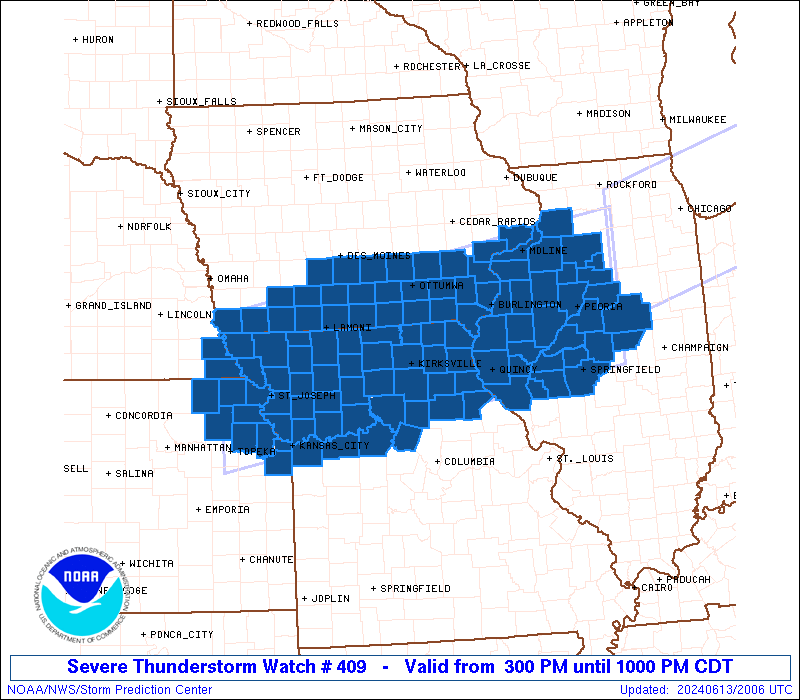
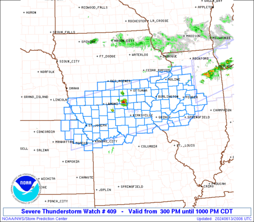
Severe Thunderstorm Watch Number 409
NWS Storm Prediction Center Norman OK
300 PM CDT Thu Jun 13 2024
The NWS Storm Prediction Center has issued a
* Severe Thunderstorm Watch for portions of
Southern Iowa
Western and Central Illinois
Northeast Kansas
Northern Missouri
Far Southeast Nebraska
* Effective this Thursday afternoon and evening from 300 PM until
1000 PM CDT.
* Primary threats include...
Scattered large hail and isolated very large hail events to 3
inches in diameter likely
Scattered damaging winds likely with isolated significant gusts
to 80 mph possible
A tornado or two possible
SUMMARY...Intense thunderstorms are expected to develop and pose a
threat for very large hail and significant severe/damaging winds
this afternoon and evening. Some of the hail could be 2-3 inches in
diameter, and severe winds may peak in the 70-80 mph range with any
line of thunderstorms that can form and spread east-southeastward.
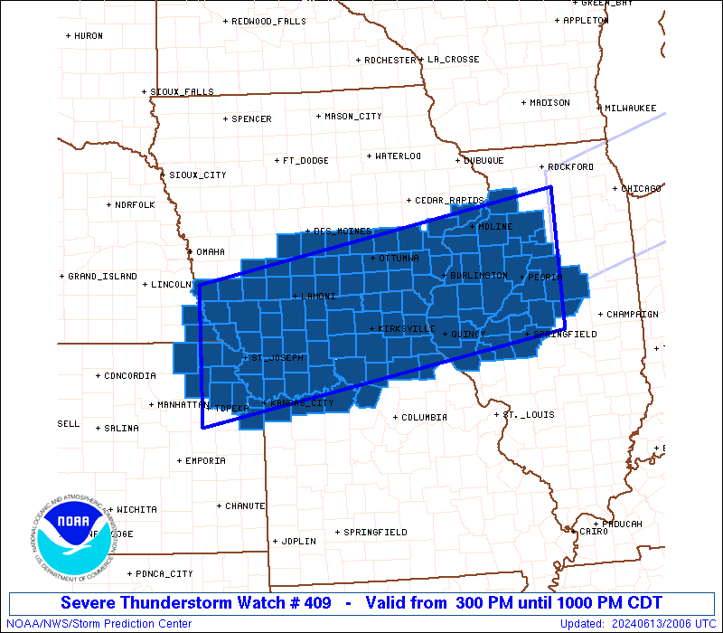
The severe thunderstorm watch area is approximately along and 70
statute miles north and south of a line from 20 miles south
southwest of Falls City NE to 40 miles east northeast of Peoria IL.
For a complete depiction of the watch see the associated watch
outline update (WOUS64 KWNS WOU9).
PRECAUTIONARY/PREPAREDNESS ACTIONS...
REMEMBER...A Severe Thunderstorm Watch means conditions are
favorable for severe thunderstorms in and close to the watch area.
Persons in these areas should be on the lookout for threatening
weather conditions and listen for later statements and possible
warnings. Severe thunderstorms can and occasionally do produce
tornadoes.
&&
OTHER WATCH INFORMATION...CONTINUE...WW 408...
AVIATION...A few severe thunderstorms with hail surface and aloft to
3 inches. Extreme turbulence and surface wind gusts to 70 knots. A
few cumulonimbi with maximum tops to 550. Mean storm motion vector
30030.
...Gleason
   SEL9

   URGENT - IMMEDIATE BROADCAST REQUESTED
   Severe Thunderstorm Watch Number 409
   NWS Storm Prediction Center Norman OK
   300 PM CDT Thu Jun 13 2024

   The NWS Storm Prediction Center has issued a

   * Severe Thunderstorm Watch for portions of
     Southern Iowa
     Western and Central Illinois
     Northeast Kansas
     Northern Missouri
     Far Southeast Nebraska

   * Effective this Thursday afternoon and evening from 300 PM until
     1000 PM CDT.

   * Primary threats include...
     Scattered large hail and isolated very large hail events to 3
       inches in diameter likely
     Scattered damaging winds likely with isolated significant gusts
       to 80 mph possible
     A tornado or two possible

   SUMMARY...Intense thunderstorms are expected to develop and pose a
   threat for very large hail and significant severe/damaging winds
   this afternoon and evening. Some of the hail could be 2-3 inches in
   diameter, and severe winds may peak in the 70-80 mph range with any
   line of thunderstorms that can form and spread east-southeastward.

   The severe thunderstorm watch area is approximately along and 70
   statute miles north and south of a line from 20 miles south
   southwest of Falls City NE to 40 miles east northeast of Peoria IL.
   For a complete depiction of the watch see the associated watch
   outline update (WOUS64 KWNS WOU9).

   PRECAUTIONARY/PREPAREDNESS ACTIONS...

   REMEMBER...A Severe Thunderstorm Watch means conditions are
   favorable for severe thunderstorms in and close to the watch area.
   Persons in these areas should be on the lookout for threatening
   weather conditions and listen for later statements and possible
   warnings. Severe thunderstorms can and occasionally do produce
   tornadoes.

   &&

   OTHER WATCH INFORMATION...CONTINUE...WW 408...

   AVIATION...A few severe thunderstorms with hail surface and aloft to
   3 inches. Extreme turbulence and surface wind gusts to 70 knots. A
   few cumulonimbi with maximum tops to 550. Mean storm motion vector
   30030.

   ...Gleason
 Note:
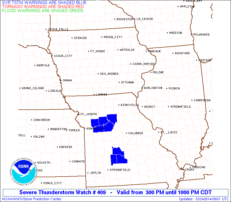
The Aviation Watch (SAW) product is an approximation to the watch area.
The actual watch is depicted by the shaded areas.
Note:
The Aviation Watch (SAW) product is an approximation to the watch area.
The actual watch is depicted by the shaded areas.
   SAW9
   WW 409 SEVERE TSTM IA IL KS MO NE 132000Z - 140300Z
   AXIS..70 STATUTE MILES NORTH AND SOUTH OF LINE..
   20SSW FNB/FALLS CITY NE/ - 40ENE PIA/PEORIA IL/
   ..AVIATION COORDS.. 60NM N/S /32SE PWE - 32ESE BDF/
   HAIL SURFACE AND ALOFT..3 INCHES. WIND GUSTS..70 KNOTS.
   MAX TOPS TO 550. MEAN STORM MOTION VECTOR 30030.

   LAT...LON 40829574 41908897 39888897 38799574

   THIS IS AN APPROXIMATION TO THE WATCH AREA.  FOR A
   COMPLETE DEPICTION OF THE WATCH SEE WOUS64 KWNS
   FOR WOU9.
Watch 409 Status Report Messages:
STATUS REPORT #3 ON WW 409

VALID 140110Z - 140240Z

SEVERE WEATHER THREAT CONTINUES RIGHT OF A LINE FROM 25 SW SDA TO
20 NW IRK TO 30 SW BRL TO 20 N BRL TO 30 WNW MLI.

..SPC..06/14/24

ATTN...WFO...DMX...DVN...OAX...LSX...ILX...EAX...TOP...

&&

STATUS REPORT FOR WS 409

SEVERE WEATHER THREAT CONTINUES FOR THE FOLLOWING AREAS

ILC001-009-011-017-039-057-067-071-073-095-107-109-113-123-125-
129-131-137-143-149-155-167-169-171-175-179-187-203-140240-

IL
.    ILLINOIS COUNTIES INCLUDED ARE

ADAMS		     BROWN		 BUREAU
CASS		     DE WITT		 FULTON
HANCOCK 	     HENDERSON		 HENRY
KNOX		     LOGAN		 MCDONOUGH
MCLEAN		     MARSHALL		 MASON
MENARD		     MERCER		 MORGAN
PEORIA		     PIKE		 PUTNAM
SANGAMON	     SCHUYLER		 SCOTT
STARK		     TAZEWELL		 WARREN
WOODFORD
$$


IAC057-111-140240-

IA
.    IOWA COUNTIES INCLUDED ARE

DES MOINES	     LEE
$$


KSC005-013-043-085-087-091-103-131-209-140240-

KS
.    KANSAS COUNTIES INCLUDED ARE

ATCHISON	     BROWN		 DONIPHAN
JACKSON 	     JEFFERSON		 JOHNSON
LEAVENWORTH	     NEMAHA		 WYANDOTTE
$$


MOC001-003-005-021-025-033-041-045-047-049-061-063-075-079-081-
087-089-095-103-107-111-115-117-121-127-129-137-147-165-171-173-
175-177-195-197-199-205-211-227-140240-

MO
.    MISSOURI COUNTIES INCLUDED ARE

ADAIR		     ANDREW		 ATCHISON
BUCHANAN	     CALDWELL		 CARROLL
CHARITON	     CLARK		 CLAY
CLINTON 	     DAVIESS		 DEKALB
GENTRY		     GRUNDY		 HARRISON
HOLT		     HOWARD		 JACKSON
KNOX		     LAFAYETTE		 LEWIS
LINN		     LIVINGSTON 	 MACON
MARION		     MERCER		 MONROE
NODAWAY 	     PLATTE		 PUTNAM
RALLS		     RANDOLPH		 RAY
SALINE		     SCHUYLER		 SCOTLAND
SHELBY		     SULLIVAN		 WORTH
$$


NEC147-140240-

NE
.    NEBRASKA COUNTIES INCLUDED ARE

RICHARDSON
$$


THE WATCH STATUS MESSAGE IS FOR GUIDANCE PURPOSES ONLY.  PLEASE
REFER TO WATCH COUNTY NOTIFICATION STATEMENTS FOR OFFICIAL
INFORMATION ON COUNTIES...INDEPENDENT CITIES AND MARINE ZONES
CLEARED FROM SEVERE THUNDERSTORM AND TORNADO WATCHES.
$$

STATUS REPORT #2 ON WW 409

VALID 132240Z - 132340Z

THE SEVERE WEATHER THREAT CONTINUES ACROSS THE ENTIRE WATCH AREA.

..SPC..06/13/24

ATTN...WFO...DMX...DVN...OAX...LSX...ILX...EAX...TOP...

&&

STATUS REPORT FOR WS 409

SEVERE WEATHER THREAT CONTINUES FOR THE FOLLOWING AREAS

ILC001-009-011-017-039-057-067-071-073-095-107-109-113-123-125-
129-131-137-143-149-155-161-167-169-171-175-179-187-195-203-
132340-

IL
.    ILLINOIS COUNTIES INCLUDED ARE

ADAMS		     BROWN		 BUREAU
CASS		     DE WITT		 FULTON
HANCOCK 	     HENDERSON		 HENRY
KNOX		     LOGAN		 MCDONOUGH
MCLEAN		     MARSHALL		 MASON
MENARD		     MERCER		 MORGAN
PEORIA		     PIKE		 PUTNAM
ROCK ISLAND	     SANGAMON		 SCHUYLER
SCOTT		     STARK		 TAZEWELL
WARREN		     WHITESIDE		 WOODFORD
$$


IAC003-007-039-051-053-057-071-087-101-107-111-115-117-121-123-
125-135-139-145-159-163-173-175-177-179-181-183-185-132340-

IA
.    IOWA COUNTIES INCLUDED ARE

ADAMS		     APPANOOSE		 CLARKE
DAVIS		     DECATUR		 DES MOINES
FREMONT 	     HENRY		 JEFFERSON
KEOKUK		     LEE		 LOUISA
LUCAS		     MADISON		 MAHASKA
MARION		     MONROE		 MUSCATINE
PAGE		     RINGGOLD		 SCOTT
TAYLOR		     UNION		 VAN BUREN
WAPELLO 	     WARREN		 WASHINGTON
WAYNE
$$


KSC005-013-043-085-087-091-103-131-209-132340-

KS
.    KANSAS COUNTIES INCLUDED ARE

ATCHISON	     BROWN		 DONIPHAN
JACKSON 	     JEFFERSON		 JOHNSON
LEAVENWORTH	     NEMAHA		 WYANDOTTE
$$


MOC001-003-005-021-025-033-041-045-047-049-061-063-075-079-081-
087-089-095-103-107-111-115-117-121-127-129-137-147-165-171-173-
175-177-195-197-199-205-211-227-132340-

MO
.    MISSOURI COUNTIES INCLUDED ARE

ADAIR		     ANDREW		 ATCHISON
BUCHANAN	     CALDWELL		 CARROLL
CHARITON	     CLARK		 CLAY
CLINTON 	     DAVIESS		 DEKALB
GENTRY		     GRUNDY		 HARRISON
HOLT		     HOWARD		 JACKSON
KNOX		     LAFAYETTE		 LEWIS
LINN		     LIVINGSTON 	 MACON
MARION		     MERCER		 MONROE
NODAWAY 	     PLATTE		 PUTNAM
RALLS		     RANDOLPH		 RAY
SALINE		     SCHUYLER		 SCOTLAND
SHELBY		     SULLIVAN		 WORTH
$$


NEC127-147-132340-

NE
.    NEBRASKA COUNTIES INCLUDED ARE

NEMAHA		     RICHARDSON
$$


THE WATCH STATUS MESSAGE IS FOR GUIDANCE PURPOSES ONLY.  PLEASE
REFER TO WATCH COUNTY NOTIFICATION STATEMENTS FOR OFFICIAL
INFORMATION ON COUNTIES...INDEPENDENT CITIES AND MARINE ZONES
CLEARED FROM SEVERE THUNDERSTORM AND TORNADO WATCHES.
$$

STATUS REPORT #1 ON WW 409

VALID 132135Z - 132240Z

THE SEVERE WEATHER THREAT CONTINUES ACROSS THE ENTIRE WATCH AREA.

..SPC..06/13/24

ATTN...WFO...DMX...DVN...OAX...LSX...ILX...EAX...TOP...

&&

STATUS REPORT FOR WS 409

SEVERE WEATHER THREAT CONTINUES FOR THE FOLLOWING AREAS

ILC001-009-011-017-039-057-067-071-073-095-107-109-113-123-125-
129-131-137-143-149-155-161-167-169-171-175-179-187-195-203-
132240-

IL
.    ILLINOIS COUNTIES INCLUDED ARE

ADAMS		     BROWN		 BUREAU
CASS		     DE WITT		 FULTON
HANCOCK 	     HENDERSON		 HENRY
KNOX		     LOGAN		 MCDONOUGH
MCLEAN		     MARSHALL		 MASON
MENARD		     MERCER		 MORGAN
PEORIA		     PIKE		 PUTNAM
ROCK ISLAND	     SANGAMON		 SCHUYLER
SCOTT		     STARK		 TAZEWELL
WARREN		     WHITESIDE		 WOODFORD
$$


IAC003-007-039-051-053-057-071-087-101-107-111-115-117-121-123-
125-135-139-145-159-163-173-175-177-179-181-183-185-132240-

IA
.    IOWA COUNTIES INCLUDED ARE

ADAMS		     APPANOOSE		 CLARKE
DAVIS		     DECATUR		 DES MOINES
FREMONT 	     HENRY		 JEFFERSON
KEOKUK		     LEE		 LOUISA
LUCAS		     MADISON		 MAHASKA
MARION		     MONROE		 MUSCATINE
PAGE		     RINGGOLD		 SCOTT
TAYLOR		     UNION		 VAN BUREN
WAPELLO 	     WARREN		 WASHINGTON
WAYNE
$$


KSC005-013-043-085-087-091-103-131-209-132240-

KS
.    KANSAS COUNTIES INCLUDED ARE

ATCHISON	     BROWN		 DONIPHAN
JACKSON 	     JEFFERSON		 JOHNSON
LEAVENWORTH	     NEMAHA		 WYANDOTTE
$$


MOC001-003-005-021-025-033-041-045-047-049-061-063-075-079-081-
087-089-095-103-107-111-115-117-121-127-129-137-147-165-171-173-
175-177-195-197-199-205-211-227-132240-

MO
.    MISSOURI COUNTIES INCLUDED ARE

ADAIR		     ANDREW		 ATCHISON
BUCHANAN	     CALDWELL		 CARROLL
CHARITON	     CLARK		 CLAY
CLINTON 	     DAVIESS		 DEKALB
GENTRY		     GRUNDY		 HARRISON
HOLT		     HOWARD		 JACKSON
KNOX		     LAFAYETTE		 LEWIS
LINN		     LIVINGSTON 	 MACON
MARION		     MERCER		 MONROE
NODAWAY 	     PLATTE		 PUTNAM
RALLS		     RANDOLPH		 RAY
SALINE		     SCHUYLER		 SCOTLAND
SHELBY		     SULLIVAN		 WORTH
$$


NEC127-147-132240-

NE
.    NEBRASKA COUNTIES INCLUDED ARE

NEMAHA		     RICHARDSON
$$


THE WATCH STATUS MESSAGE IS FOR GUIDANCE PURPOSES ONLY.  PLEASE
REFER TO WATCH COUNTY NOTIFICATION STATEMENTS FOR OFFICIAL
INFORMATION ON COUNTIES...INDEPENDENT CITIES AND MARINE ZONES
CLEARED FROM SEVERE THUNDERSTORM AND TORNADO WATCHES.
$$
Note:
Click for Complete Product Text.
Tornadoes
Probability of 2 or more tornadoes
|
Low (20%)
|
Probability of 1 or more strong (EF2-EF5) tornadoes
|
Low (10%)
|
Wind
Probability of 10 or more severe wind events
|
High (70%)
|
Probability of 1 or more wind events > 65 knots
|
Mod (50%)
|
Hail
Probability of 10 or more severe hail events
|
High (70%)
|
Probability of 1 or more hailstones > 2 inches
|
Mod (60%)
|
Combined Severe Hail/Wind
Probability of 6 or more combined severe hail/wind events
|
High (90%)
|
For each watch, probabilities for particular events inside the watch
(listed above in each table) are determined by the issuing forecaster.
The "Low" category contains probability values ranging from less than 2%
to 20% (EF2-EF5 tornadoes), less than 5% to 20% (all other probabilities),
"Moderate" from 30% to 60%, and "High" from 70% to greater than 95%.
High values are bolded and lighter in color to provide awareness of
an increased threat for a particular event.


 @NWSSPC