 Note:
The expiration time in the watch graphic is amended if the watch is
replaced, cancelled or extended.
Note:
Note:
The expiration time in the watch graphic is amended if the watch is
replaced, cancelled or extended.
Note: Click for
Watch Status Reports.
SEL3
URGENT - IMMEDIATE BROADCAST REQUESTED
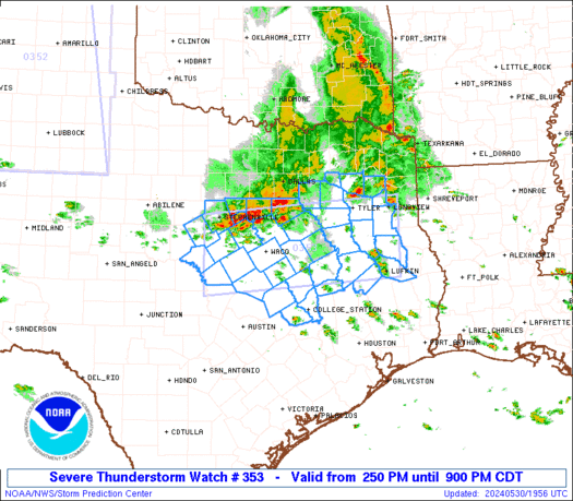
Severe Thunderstorm Watch Number 353
NWS Storm Prediction Center Norman OK
250 PM CDT Thu May 30 2024
The NWS Storm Prediction Center has issued a
* Severe Thunderstorm Watch for portions of
North-Central and East Texas
* Effective this Thursday afternoon and evening from 250 PM until
900 PM CDT.
* Primary threats include...
Scattered damaging wind gusts to 65 mph possible
Scattered large hail events to 1.5 inches in diameter possible
A tornado or two possible
SUMMARY...Scattered strong to severe thunderstorms should continue
to develop and organize through the afternoon, as they generally
move east-southeastward across the region.
The severe thunderstorm watch area is approximately along and 50
statute miles north and south of a line from 50 miles south
southwest of Stephenville TX to 40 miles south southeast of Longview
TX. For a complete depiction of the watch see the associated watch
outline update (WOUS64 KWNS WOU3).
PRECAUTIONARY/PREPAREDNESS ACTIONS...
REMEMBER...A Severe Thunderstorm Watch means conditions are
favorable for severe thunderstorms in and close to the watch area.
Persons in these areas should be on the lookout for threatening
weather conditions and listen for later statements and possible
warnings. Severe thunderstorms can and occasionally do produce
tornadoes.
&&
OTHER WATCH INFORMATION...CONTINUE...WW 352...
AVIATION...A few severe thunderstorms with hail surface and aloft to
1.5 inches. Extreme turbulence and surface wind gusts to 55 knots. A
few cumulonimbi with maximum tops to 500. Mean storm motion vector
28025.
...Guyer

   SEL3

   URGENT - IMMEDIATE BROADCAST REQUESTED
   Severe Thunderstorm Watch Number 353
   NWS Storm Prediction Center Norman OK
   250 PM CDT Thu May 30 2024

   The NWS Storm Prediction Center has issued a

   * Severe Thunderstorm Watch for portions of
     North-Central and East Texas

   * Effective this Thursday afternoon and evening from 250 PM until
     900 PM CDT.

   * Primary threats include...
     Scattered damaging wind gusts to 65 mph possible
     Scattered large hail events to 1.5 inches in diameter possible
     A tornado or two possible

   SUMMARY...Scattered strong to severe thunderstorms should continue
   to develop and organize through the afternoon, as they generally
   move east-southeastward across the region.

   The severe thunderstorm watch area is approximately along and 50
   statute miles north and south of a line from 50 miles south
   southwest of Stephenville TX to 40 miles south southeast of Longview
   TX. For a complete depiction of the watch see the associated watch
   outline update (WOUS64 KWNS WOU3).

   PRECAUTIONARY/PREPAREDNESS ACTIONS...

   REMEMBER...A Severe Thunderstorm Watch means conditions are
   favorable for severe thunderstorms in and close to the watch area.
   Persons in these areas should be on the lookout for threatening
   weather conditions and listen for later statements and possible
   warnings. Severe thunderstorms can and occasionally do produce
   tornadoes.

   &&

   OTHER WATCH INFORMATION...CONTINUE...WW 352...

   AVIATION...A few severe thunderstorms with hail surface and aloft to
   1.5 inches. Extreme turbulence and surface wind gusts to 55 knots. A
   few cumulonimbi with maximum tops to 500. Mean storm motion vector
   28025.

   ...Guyer
 Note:
The Aviation Watch (SAW) product is an approximation to the watch area.
The actual watch is depicted by the shaded areas.
Note:
The Aviation Watch (SAW) product is an approximation to the watch area.
The actual watch is depicted by the shaded areas.
   SAW3
   WW 353 SEVERE TSTM TX 301950Z - 310200Z
   AXIS..50 STATUTE MILES NORTH AND SOUTH OF LINE..
   50SSW SEP/STEPHENVILLE TX/ - 40SSE GGG/LONGVIEW TX/
   ..AVIATION COORDS.. 45NM N/S /63W ACT - 38SSE GGG/
   HAIL SURFACE AND ALOFT..1.5 INCHES. WIND GUSTS..55 KNOTS.
   MAX TOPS TO 500. MEAN STORM MOTION VECTOR 28025.

   LAT...LON 32279850 32579446 31129446 30839850

   THIS IS AN APPROXIMATION TO THE WATCH AREA.  FOR A
   COMPLETE DEPICTION OF THE WATCH SEE WOUS64 KWNS
   FOR WOU3.
Watch 353 Status Report Messages:
STATUS REPORT #5 ON WW 353

VALID 310030Z - 310140Z

SEVERE WEATHER THREAT CONTINUES RIGHT OF A LINE FROM 25 NE BWD TO
25 WNW UTS TO 20 NNE LFK TO 30 NNE GGG.

..DEAN..05/31/24

ATTN...WFO...FWD...SHV...HGX...

&&

STATUS REPORT FOR WS 353

SEVERE WEATHER THREAT CONTINUES FOR THE FOLLOWING AREAS

TXC005-015-027-041-051-093-099-145-185-193-201-281-291-313-331-
333-339-347-373-395-407-455-471-473-477-310140-

TX
.    TEXAS COUNTIES INCLUDED ARE

ANGELINA	     AUSTIN		 BELL
BRAZOS		     BURLESON		 COMANCHE
CORYELL 	     FALLS		 GRIMES
HAMILTON	     HARRIS		 LAMPASAS
LIBERTY 	     MADISON		 MILAM
MILLS		     MONTGOMERY 	 NACOGDOCHES
POLK		     ROBERTSON		 SAN JACINTO
TRINITY 	     WALKER		 WALLER
WASHINGTON
$$


THE WATCH STATUS MESSAGE IS FOR GUIDANCE PURPOSES ONLY.  PLEASE
REFER TO WATCH COUNTY NOTIFICATION STATEMENTS FOR OFFICIAL
INFORMATION ON COUNTIES...INDEPENDENT CITIES AND MARINE ZONES
CLEARED FROM SEVERE THUNDERSTORM AND TORNADO WATCHES.
$$

STATUS REPORT #4 ON WW 353

VALID 302340Z - 310040Z

SEVERE WEATHER THREAT CONTINUES RIGHT OF A LINE FROM 30 N BWD TO
45 N CLL TO 30 NNW SHV.

..DEAN..05/30/24

ATTN...WFO...FWD...SHV...HGX...

&&

STATUS REPORT FOR WS 353

SEVERE WEATHER THREAT CONTINUES FOR THE FOLLOWING AREAS

TXC005-027-041-051-073-093-099-145-193-225-281-289-313-331-333-
347-395-401-455-310040-

TX
.    TEXAS COUNTIES INCLUDED ARE

ANGELINA	     BELL		 BRAZOS
BURLESON	     CHEROKEE		 COMANCHE
CORYELL 	     FALLS		 HAMILTON
HOUSTON 	     LAMPASAS		 LEON
MADISON 	     MILAM		 MILLS
NACOGDOCHES	     ROBERTSON		 RUSK
TRINITY
$$


THE WATCH STATUS MESSAGE IS FOR GUIDANCE PURPOSES ONLY.  PLEASE
REFER TO WATCH COUNTY NOTIFICATION STATEMENTS FOR OFFICIAL
INFORMATION ON COUNTIES...INDEPENDENT CITIES AND MARINE ZONES
CLEARED FROM SEVERE THUNDERSTORM AND TORNADO WATCHES.
$$

STATUS REPORT #3 ON WW 353

VALID 302245Z - 302340Z

SEVERE WEATHER THREAT CONTINUES RIGHT OF A LINE FROM 30 NNE BWD
TO ACT TO 40 SSW TXK.

FOR ADDITIONAL INFORMATION SEE MESOSCALE DISCUSSION 1083

..DEAN..05/30/24

ATTN...WFO...FWD...SHV...HGX...

&&

STATUS REPORT FOR WS 353

SEVERE WEATHER THREAT CONTINUES FOR THE FOLLOWING AREAS

TXC001-005-027-041-051-073-093-099-145-161-183-193-225-281-289-
293-309-313-331-333-347-395-401-423-455-459-302340-

TX
.    TEXAS COUNTIES INCLUDED ARE

ANDERSON	     ANGELINA		 BELL
BRAZOS		     BURLESON		 CHEROKEE
COMANCHE	     CORYELL		 FALLS
FREESTONE	     GREGG		 HAMILTON
HOUSTON 	     LAMPASAS		 LEON
LIMESTONE	     MCLENNAN		 MADISON
MILAM		     MILLS		 NACOGDOCHES
ROBERTSON	     RUSK		 SMITH
TRINITY 	     UPSHUR
$$


THE WATCH STATUS MESSAGE IS FOR GUIDANCE PURPOSES ONLY.  PLEASE
REFER TO WATCH COUNTY NOTIFICATION STATEMENTS FOR OFFICIAL
INFORMATION ON COUNTIES...INDEPENDENT CITIES AND MARINE ZONES
CLEARED FROM SEVERE THUNDERSTORM AND TORNADO WATCHES.
$$

STATUS REPORT #2 ON WW 353

VALID 302130Z - 302240Z

THE SEVERE WEATHER THREAT CONTINUES ACROSS THE ENTIRE WATCH AREA.

..DEAN..05/30/24

ATTN...WFO...FWD...SHV...HGX...

&&

STATUS REPORT FOR WS 353

SEVERE WEATHER THREAT CONTINUES FOR THE FOLLOWING AREAS

TXC001-005-027-035-041-051-073-093-099-139-143-145-161-183-193-
213-217-221-225-251-257-281-289-293-309-313-331-333-347-349-379-
395-401-423-425-455-459-467-499-302240-

TX
.    TEXAS COUNTIES INCLUDED ARE

ANDERSON	     ANGELINA		 BELL
BOSQUE		     BRAZOS		 BURLESON
CHEROKEE	     COMANCHE		 CORYELL
ELLIS		     ERATH		 FALLS
FREESTONE	     GREGG		 HAMILTON
HENDERSON	     HILL		 HOOD
HOUSTON 	     JOHNSON		 KAUFMAN
LAMPASAS	     LEON		 LIMESTONE
MCLENNAN	     MADISON		 MILAM
MILLS		     NACOGDOCHES	 NAVARRO
RAINS		     ROBERTSON		 RUSK
SMITH		     SOMERVELL		 TRINITY
UPSHUR		     VAN ZANDT		 WOOD
$$


THE WATCH STATUS MESSAGE IS FOR GUIDANCE PURPOSES ONLY.  PLEASE
REFER TO WATCH COUNTY NOTIFICATION STATEMENTS FOR OFFICIAL
INFORMATION ON COUNTIES...INDEPENDENT CITIES AND MARINE ZONES
CLEARED FROM SEVERE THUNDERSTORM AND TORNADO WATCHES.
$$

STATUS REPORT #1 ON WW 353

VALID 302025Z - 302140Z

THE SEVERE WEATHER THREAT CONTINUES ACROSS THE ENTIRE WATCH AREA.

..DEAN..05/30/24

ATTN...WFO...FWD...SHV...HGX...

&&

STATUS REPORT FOR WS 353

SEVERE WEATHER THREAT CONTINUES FOR THE FOLLOWING AREAS

TXC001-005-027-035-041-051-073-093-099-139-143-145-161-183-193-
213-217-221-225-251-257-281-289-293-309-313-331-333-347-349-379-
395-401-423-425-455-459-467-499-302140-

TX
.    TEXAS COUNTIES INCLUDED ARE

ANDERSON	     ANGELINA		 BELL
BOSQUE		     BRAZOS		 BURLESON
CHEROKEE	     COMANCHE		 CORYELL
ELLIS		     ERATH		 FALLS
FREESTONE	     GREGG		 HAMILTON
HENDERSON	     HILL		 HOOD
HOUSTON 	     JOHNSON		 KAUFMAN
LAMPASAS	     LEON		 LIMESTONE
MCLENNAN	     MADISON		 MILAM
MILLS		     NACOGDOCHES	 NAVARRO
RAINS		     ROBERTSON		 RUSK
SMITH		     SOMERVELL		 TRINITY
UPSHUR		     VAN ZANDT		 WOOD
$$


THE WATCH STATUS MESSAGE IS FOR GUIDANCE PURPOSES ONLY.  PLEASE
REFER TO WATCH COUNTY NOTIFICATION STATEMENTS FOR OFFICIAL
INFORMATION ON COUNTIES...INDEPENDENT CITIES AND MARINE ZONES
CLEARED FROM SEVERE THUNDERSTORM AND TORNADO WATCHES.
$$
Note:
Click for Complete Product Text.
Tornadoes
Probability of 2 or more tornadoes
|
Low (20%)
|
Probability of 1 or more strong (EF2-EF5) tornadoes
|
Low (5%)
|
Wind
Probability of 10 or more severe wind events
|
Mod (50%)
|
Probability of 1 or more wind events > 65 knots
|
Low (20%)
|
Hail
Probability of 10 or more severe hail events
|
Mod (50%)
|
Probability of 1 or more hailstones > 2 inches
|
Low (20%)
|
Combined Severe Hail/Wind
Probability of 6 or more combined severe hail/wind events
|
High (90%)
|
For each watch, probabilities for particular events inside the watch
(listed above in each table) are determined by the issuing forecaster.
The "Low" category contains probability values ranging from less than 2%
to 20% (EF2-EF5 tornadoes), less than 5% to 20% (all other probabilities),
"Moderate" from 30% to 60%, and "High" from 70% to greater than 95%.
High values are bolded and lighter in color to provide awareness of
an increased threat for a particular event.


 @NWSSPC


