Note:
The expiration time in the watch graphic is amended if the watch is
replaced, cancelled or extended.
Note:
Note:
The expiration time in the watch graphic is amended if the watch is
replaced, cancelled or extended.
Note: Click for
Watch Status Reports.
SEL5
URGENT - IMMEDIATE BROADCAST REQUESTED
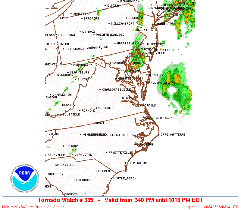
Tornado Watch Number 335
NWS Storm Prediction Center Norman OK
340 PM EDT Mon May 27 2024
The NWS Storm Prediction Center has issued a
* Tornado Watch for portions of
District Of Columbia
Central and Eastern Maryland
Central and Eastern North Carolina
Eastern and Northern Virginia
Coastal Waters
* Effective this Monday afternoon and evening from 340 PM until
1100 PM EDT.
* Primary threats include...
A couple tornadoes possible
Scattered damaging wind gusts to 70 mph possible
Isolated large hail events to 1.5 inches in diameter possible
SUMMARY...Severe thunderstorms are expected to develop through the
afternoon across the region. Damaging winds are expected to be the
most common risk, but some hail is possible, and a moist environment
and strong atmospheric winds will also support a tornado risk.
The tornado watch area is approximately along and 75 statute miles
east and west of a line from 40 miles north northeast of Baltimore
MD to Jacksonville NC. For a complete depiction of the watch see the
associated watch outline update (WOUS64 KWNS WOU5).
PRECAUTIONARY/PREPAREDNESS ACTIONS...
REMEMBER...A Tornado Watch means conditions are favorable for
tornadoes and severe thunderstorms in and close to the watch
area. Persons in these areas should be on the lookout for
threatening weather conditions and listen for later statements
and possible warnings.
&&
OTHER WATCH INFORMATION...CONTINUE...WW 333...WW 334...
AVIATION...Tornadoes and a few severe thunderstorms with hail
surface and aloft to 1.5 inches. Extreme turbulence and surface wind
gusts to 60 knots. A few cumulonimbi with maximum tops to 500. Mean
storm motion vector 24030.
...Guyer

   SEL5

   URGENT - IMMEDIATE BROADCAST REQUESTED
   Tornado Watch Number 335
   NWS Storm Prediction Center Norman OK
   340 PM EDT Mon May 27 2024

   The NWS Storm Prediction Center has issued a

   * Tornado Watch for portions of
     District Of Columbia
     Central and Eastern Maryland
     Central and Eastern North Carolina
     Eastern and Northern Virginia
     Coastal Waters

   * Effective this Monday afternoon and evening from 340 PM until
     1100 PM EDT.

   * Primary threats include...
     A couple tornadoes possible
     Scattered damaging wind gusts to 70 mph possible
     Isolated large hail events to 1.5 inches in diameter possible

   SUMMARY...Severe thunderstorms are expected to develop through the
   afternoon across the region. Damaging winds are expected to be the
   most common risk, but some hail is possible, and a moist environment
   and strong atmospheric winds will also support a tornado risk.

   The tornado watch area is approximately along and 75 statute miles
   east and west of a line from 40 miles north northeast of Baltimore
   MD to Jacksonville NC. For a complete depiction of the watch see the
   associated watch outline update (WOUS64 KWNS WOU5).

   PRECAUTIONARY/PREPAREDNESS ACTIONS...

   REMEMBER...A Tornado Watch means conditions are favorable for
   tornadoes and severe thunderstorms in and close to the watch
   area. Persons in these areas should be on the lookout for
   threatening weather conditions and listen for later statements
   and possible warnings.

   &&

   OTHER WATCH INFORMATION...CONTINUE...WW 333...WW 334...

   AVIATION...Tornadoes and a few severe thunderstorms with hail
   surface and aloft to 1.5 inches. Extreme turbulence and surface wind
   gusts to 60 knots. A few cumulonimbi with maximum tops to 500. Mean
   storm motion vector 24030.

   ...Guyer
 Note:
The Aviation Watch (SAW) product is an approximation to the watch area.
The actual watch is depicted by the shaded areas.
Note:
The Aviation Watch (SAW) product is an approximation to the watch area.
The actual watch is depicted by the shaded areas.
   SAW5
   WW 335 TORNADO DC MD NC VA CW 271940Z - 280300Z
   AXIS..75 STATUTE MILES EAST AND WEST OF LINE..
   40NNE BWI/BALTIMORE MD/ - OAJ/JACKSONVILLE NC/
   ..AVIATION COORDS.. 65NM E/W /31ENE EMI - 31NNE ILM/
   HAIL SURFACE AND ALOFT..1.5 INCHES. WIND GUSTS..60 KNOTS.
   MAX TOPS TO 500. MEAN STORM MOTION VECTOR 24030.

   LAT...LON 39717497 34827630 34827894 39717779

   THIS IS AN APPROXIMATION TO THE WATCH AREA.  FOR A
   COMPLETE DEPICTION OF THE WATCH SEE WOUS64 KWNS
   FOR WOU5.
Watch 335 Status Report Messages:
STATUS REPORT #3 ON WW 335

VALID 280135Z - 280240Z

SEVERE WEATHER THREAT CONTINUES RIGHT OF A LINE FROM 30 ENE SBY
TO 10 WSW NHK TO 15 ENE DCA TO 15 E BWI TO 15 WSW ACY.

..MOORE..05/28/24

ATTN...WFO...LWX...AKQ...MHX...RAH...

&&

STATUS REPORT FOR WT 335

SEVERE WEATHER THREAT CONTINUES FOR THE FOLLOWING AREAS

MDC003-009-280240-

MD
.    MARYLAND COUNTIES INCLUDED ARE

ANNE ARUNDEL	     CALVERT
$$


ANZ532-533-539-540-541-542-280240-

CW

.    ADJACENT COASTAL WATERS INCLUDED ARE

CHESAPEAKE BAY FROM SANDY POINT TO NORTH BEACH MD

CHESAPEAKE BAY FROM NORTH BEACH TO DRUM POINT MD

CHESTER RIVER TO QUEENSTOWN MD

EASTERN BAY

CHOPTANK RIVER TO CAMBRIDGE MD AND THE LITTLE CHOPTANK RIVER

PATUXENT RIVER TO BROOMES ISLAND MD

$$
THE WATCH STATUS MESSAGE IS FOR GUIDANCE PURPOSES ONLY.  PLEASE
REFER TO WATCH COUNTY NOTIFICATION STATEMENTS FOR OFFICIAL
INFORMATION ON COUNTIES...INDEPENDENT CITIES AND MARINE ZONES
CLEARED FROM SEVERE THUNDERSTORM AND TORNADO WATCHES.
$$

STATUS REPORT #2 ON WW 335

VALID 280010Z - 280140Z

SEVERE WEATHER THREAT CONTINUES RIGHT OF A LINE FROM 40 SSE WAL
TO 40 ENE CHO TO 25 SE MRB TO 25 SSE CXY.

FOR ADDITIONAL INFORMATION SEE MESOSCALE DISCUSSION 1025

..MOORE..05/28/24

ATTN...WFO...LWX...AKQ...MHX...RAH...

&&

STATUS REPORT FOR WT 335

SEVERE WEATHER THREAT CONTINUES FOR THE FOLLOWING AREAS

DCC001-280140-

DC
.    DISTRICT OF COLUMBIA COUNTIES INCLUDED ARE

DISTRICT OF COLUMBIA
$$


MDC003-005-009-013-015-017-019-025-027-031-033-037-039-045-047-
510-280140-

MD
.    MARYLAND COUNTIES INCLUDED ARE

ANNE ARUNDEL	     BALTIMORE		 CALVERT
CARROLL 	     CECIL		 CHARLES
DORCHESTER	     HARFORD		 HOWARD
MONTGOMERY	     PRINCE GEORGES	 ST. MARYS
SOMERSET	     WICOMICO		 WORCESTER


MARYLAND INDEPENDENT CITIES INCLUDED ARE

BALTIMORE CITY
$$


VAC001-013-059-099-107-133-153-179-193-510-600-610-630-683-685-
280140-

VA
.    VIRGINIA COUNTIES INCLUDED ARE

ACCOMACK	     ARLINGTON		 FAIRFAX
KING GEORGE	     LOUDOUN		 NORTHUMBERLAND
PRINCE WILLIAM	     STAFFORD		 WESTMORELAND


VIRGINIA INDEPENDENT CITIES INCLUDED ARE

ALEXANDRIA	     FAIRFAX		 FALLS CHURCH
FREDERICKSBURG	     MANASSAS		 MANASSAS PARK
$$


ANZ530-531-532-533-534-535-536-537-538-539-540-541-542-543-630-
650-652-280140-

CW

.    ADJACENT COASTAL WATERS INCLUDED ARE

CHESAPEAKE BAY NORTH OF POOLES ISLAND MD

CHESAPEAKE BAY FROM POOLES ISLAND TO SANDY POINT MD

CHESAPEAKE BAY FROM SANDY POINT TO NORTH BEACH MD

CHESAPEAKE BAY FROM NORTH BEACH TO DRUM POINT MD

CHESAPEAKE BAY FROM DRUM POINT MD TO SMITH POINT VA

TIDAL POTOMAC FROM KEY BRIDGE TO INDIAN HEAD MD

TIDAL POTOMAC FROM INDIAN HEAD TO COBB ISLAND MD

TIDAL POTOMAC FROM COBB ISLAND MD TO SMITH POINT VA

PATAPSCO RIVER INCLUDING BALTIMORE HARBOR

CHESTER RIVER TO QUEENSTOWN MD

EASTERN BAY

CHOPTANK RIVER TO CAMBRIDGE MD AND THE LITTLE CHOPTANK RIVER

PATUXENT RIVER TO BROOMES ISLAND MD

TANGIER SOUND AND THE INLAND WATERS SURROUNDING BLOODSWORTH
ISLAND

CHESAPEAKE BAY FROM SMITH POINT TO WINDMILL POINT VA

COASTAL WATERS FROM FENWICK ISLAND DE TO CHINCOTEAGUE VA OUT 20
NM

COASTAL WATERS FROM CHINCOTEAGUE TO PARRAMORE ISLAND VA OUT 20 NM

$$
THE WATCH STATUS MESSAGE IS FOR GUIDANCE PURPOSES ONLY.  PLEASE
REFER TO WATCH COUNTY NOTIFICATION STATEMENTS FOR OFFICIAL
INFORMATION ON COUNTIES...INDEPENDENT CITIES AND MARINE ZONES
CLEARED FROM SEVERE THUNDERSTORM AND TORNADO WATCHES.
$$

STATUS REPORT #1 ON WW 335

VALID 272220Z - 272340Z

SEVERE WEATHER THREAT CONTINUES RIGHT OF A LINE FROM 30 SSE FAY
TO 15 SW RWI TO 25 ENE AVC TO 20 WNW RIC TO 5 SSW CHO.

..MOORE..05/27/24

ATTN...WFO...LWX...AKQ...MHX...RAH...

&&

STATUS REPORT FOR WT 335

SEVERE WEATHER THREAT CONTINUES FOR THE FOLLOWING AREAS

DCC001-272340-

DC
.    DISTRICT OF COLUMBIA COUNTIES INCLUDED ARE

DISTRICT OF COLUMBIA
$$


MDC003-005-009-013-015-017-019-021-025-027-031-033-037-039-045-
047-510-272340-

MD
.    MARYLAND COUNTIES INCLUDED ARE

ANNE ARUNDEL	     BALTIMORE		 CALVERT
CARROLL 	     CECIL		 CHARLES
DORCHESTER	     FREDERICK		 HARFORD
HOWARD		     MONTGOMERY 	 PRINCE GEORGES
ST. MARYS	     SOMERSET		 WICOMICO
WORCESTER


MARYLAND INDEPENDENT CITIES INCLUDED ARE

BALTIMORE CITY
$$


NCC013-015-029-031-041-049-053-055-061-065-073-079-083-091-095-
103-107-117-131-133-137-139-143-147-163-177-187-191-195-
272340-

NC
.    NORTH CAROLINA COUNTIES INCLUDED ARE

BEAUFORT	     BERTIE		 CAMDEN
CARTERET	     CHOWAN		 CRAVEN
CURRITUCK	     DARE		 DUPLIN
EDGECOMBE	     GATES		 GREENE
HALIFAX 	     HERTFORD		 HYDE
JONES		     LENOIR		 MARTIN
NORTHAMPTON	     ONSLOW		 PAMLICO
PASQUOTANK	     PERQUIMANS 	 PITT
SAMPSON 	     TYRRELL		 WASHINGTON
WAYNE		     WILSON
$$


VAC001-013-033-036-041-047-057-059-061-073-081-085-087-093-095-
097-099-101-103-107-109-113-115-119-127-131-133-137-149-153-157-
159-175-177-179-181-183-193-199-510-550-570-595-600-610-620-630-
650-670-683-685-700-710-730-735-740-760-800-810-830-272340-

VA
.    VIRGINIA COUNTIES INCLUDED ARE

ACCOMACK	     ARLINGTON		 CAROLINE
CHARLES CITY	     CHESTERFIELD	 CULPEPER
ESSEX		     FAIRFAX		 FAUQUIER
GLOUCESTER	     GREENSVILLE	 HANOVER
HENRICO 	     ISLE OF WIGHT	 JAMES CITY
KING AND QUEEN	     KING GEORGE	 KING WILLIAM
LANCASTER	     LOUDOUN		 LOUISA
MADISON 	     MATHEWS		 MIDDLESEX
NEW KENT	     NORTHAMPTON	 NORTHUMBERLAND
ORANGE		     PRINCE GEORGE	 PRINCE WILLIAM
RAPPAHANNOCK	     RICHMOND		 SOUTHAMPTON
SPOTSYLVANIA	     STAFFORD		 SURRY
SUSSEX		     WESTMORELAND	 YORK


VIRGINIA INDEPENDENT CITIES INCLUDED ARE

ALEXANDRIA	     CHESAPEAKE 	 COLONIAL HEIGHTS
EMPORIA 	     FAIRFAX		 FALLS CHURCH
FRANKLIN	     FREDERICKSBURG	 HAMPTON
HOPEWELL	     MANASSAS		 MANASSAS PARK
NEWPORT NEWS	     NORFOLK		 PETERSBURG
POQUOSON	     PORTSMOUTH 	 RICHMOND
SUFFOLK 	     VIRGINIA BEACH	 WILLIAMSBURG
$$


AMZ131-135-136-137-150-152-154-156-158-230-231-ANZ530-531-532-533-
534-535-536-537-538-539-540-541-542-543-630-631-632-633-634-635-
636-637-638-650-652-654-656-658-272340-

CW

.    ADJACENT COASTAL WATERS INCLUDED ARE

ALLIGATOR RIVER

PAMLICO SOUND

PAMLICO AND PUNGO RIVERS

NEUSE AND BAY RIVERS

S OF CURRITUCK BEACH LIGHT NC TO OREGON INLET NC OUT TO 20 NM

S OF OREGON INLET NC TO CAPE HATTERAS NC OUT TO 20 NM

S OF CAPE HATTERAS NC TO OCRACOKE INLET NC OUT TO 20 NM

S OF OCRACOKE INLET NC TO CAPE LOOKOUT NC OUT TO 20 NM

S OF CAPE LOOKOUT NC TO SURF CITY NC OUT TO 20 NM

ALBEMARLE SOUND

CROATAN AND ROANOKE SOUNDS

CHESAPEAKE BAY NORTH OF POOLES ISLAND MD

CHESAPEAKE BAY FROM POOLES ISLAND TO SANDY POINT MD

CHESAPEAKE BAY FROM SANDY POINT TO NORTH BEACH MD

CHESAPEAKE BAY FROM NORTH BEACH TO DRUM POINT MD

CHESAPEAKE BAY FROM DRUM POINT MD TO SMITH POINT VA

TIDAL POTOMAC FROM KEY BRIDGE TO INDIAN HEAD MD

TIDAL POTOMAC FROM INDIAN HEAD TO COBB ISLAND MD

TIDAL POTOMAC FROM COBB ISLAND MD TO SMITH POINT VA

PATAPSCO RIVER INCLUDING BALTIMORE HARBOR

CHESTER RIVER TO QUEENSTOWN MD

EASTERN BAY

CHOPTANK RIVER TO CAMBRIDGE MD AND THE LITTLE CHOPTANK RIVER

PATUXENT RIVER TO BROOMES ISLAND MD

TANGIER SOUND AND THE INLAND WATERS SURROUNDING BLOODSWORTH
ISLAND

CHESAPEAKE BAY FROM SMITH POINT TO WINDMILL POINT VA

CHESAPEAKE BAY FROM WINDMILL POINT TO NEW POINT COMFORT VA

CHESAPEAKE BAY FROM NEW POINT COMFORT TO LITTLE CREEK VA

CURRITUCK SOUND

CHESAPEAKE BAY FROM LITTLE CREEK VA TO CAPE HENRY VA INCLUDING
THE CHESAPEAKE BAY BRIDGE TUNNEL

RAPPAHANNOCK RIVER FROM URBANNA TO WINDMILL POINT

YORK RIVER

JAMES RIVER FROM JAMESTOWN TO THE JAMES RIVER BRIDGE

JAMES RIVER FROM JAMES RIVER BRIDGE TO HAMPTON ROADS
BRIDGE-TUNNEL

COASTAL WATERS FROM FENWICK ISLAND DE TO CHINCOTEAGUE VA OUT 20
NM

COASTAL WATERS FROM CHINCOTEAGUE TO PARRAMORE ISLAND VA OUT 20 NM

COASTAL WATERS FROM PARRAMORE ISLAND TO CAPE CHARLES LIGHT VA OUT
20 NM

COASTAL WATERS FROM CAPE CHARLES LIGHT TO VIRGINIA-NORTH CAROLINA
BORDER OUT TO 20 NM

COASTAL WATERS FROM NC VA BORDER TO CURRITUCK BEACH LIGHT NC OUT
20 NM

$$
THE WATCH STATUS MESSAGE IS FOR GUIDANCE PURPOSES ONLY.  PLEASE
REFER TO WATCH COUNTY NOTIFICATION STATEMENTS FOR OFFICIAL
INFORMATION ON COUNTIES...INDEPENDENT CITIES AND MARINE ZONES
CLEARED FROM SEVERE THUNDERSTORM AND TORNADO WATCHES.
$$
Note:
Click for Complete Product Text.
Tornadoes
Probability of 2 or more tornadoes
|
Mod (40%)
|
Probability of 1 or more strong (EF2-EF5) tornadoes
|
Low (20%)
|
Wind
Probability of 10 or more severe wind events
|
Mod (40%)
|
Probability of 1 or more wind events > 65 knots
|
Low (20%)
|
Hail
Probability of 10 or more severe hail events
|
Mod (30%)
|
Probability of 1 or more hailstones > 2 inches
|
Low (10%)
|
Combined Severe Hail/Wind
Probability of 6 or more combined severe hail/wind events
|
High (80%)
|
For each watch, probabilities for particular events inside the watch
(listed above in each table) are determined by the issuing forecaster.
The "Low" category contains probability values ranging from less than 2%
to 20% (EF2-EF5 tornadoes), less than 5% to 20% (all other probabilities),
"Moderate" from 30% to 60%, and "High" from 70% to greater than 95%.
High values are bolded and lighter in color to provide awareness of
an increased threat for a particular event.


 @NWSSPC