 Note:
The expiration time in the watch graphic is amended if the watch is
replaced, cancelled or extended.
Note:
Note:
The expiration time in the watch graphic is amended if the watch is
replaced, cancelled or extended.
Note: Click for
Watch Status Reports.
SEL7
URGENT - IMMEDIATE BROADCAST REQUESTED
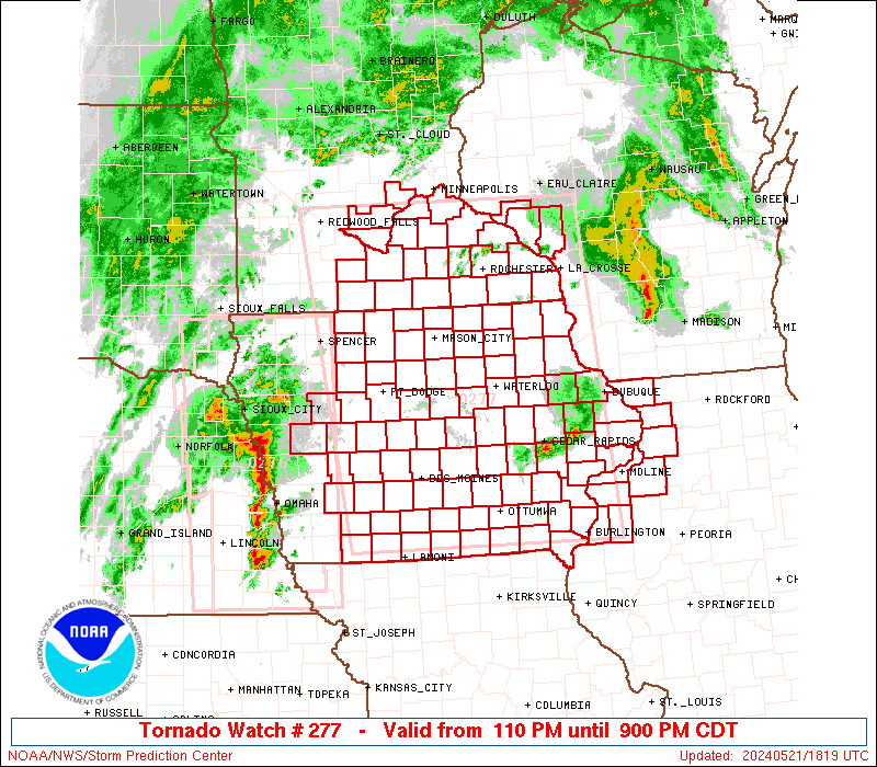
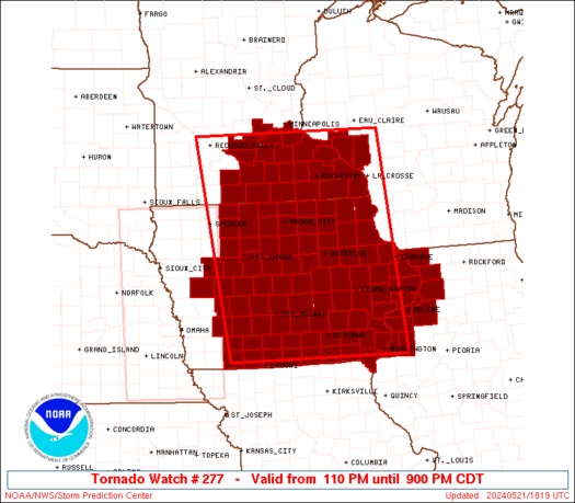
Tornado Watch Number 277
NWS Storm Prediction Center Norman OK
110 PM CDT Tue May 21 2024
The NWS Storm Prediction Center has issued a
* Tornado Watch for portions of
Iowa
Northwest Illinois
Southeast Minnesota
Western Wisconsin
* Effective this Tuesday afternoon and evening from 110 PM until
900 PM CDT.
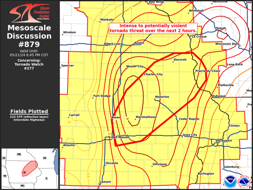
...THIS IS A PARTICULARLY DANGEROUS SITUATION...
* Primary threats include...
Several tornadoes and a few intense tornadoes likely
Widespread damaging winds and isolated significant gusts to 90
mph likely
Scattered large hail likely with isolated very large hail events
to 4 inches in diameter possible
SUMMARY...An increasingly volatile environment and very strong
atmospheric winds are expected to yield an outbreak of severe storms
including tornadoes and widespread damaging winds across the region
through the afternoon and early evening.
The tornado watch area is approximately along and 110 statute miles
east and west of a line from 30 miles south southwest of Ottumwa IA
to 50 miles northeast of Mankato MN. For a complete depiction of the
watch see the associated watch outline update (WOUS64 KWNS WOU7).
PRECAUTIONARY/PREPAREDNESS ACTIONS...
REMEMBER...A Tornado Watch means conditions are favorable for
tornadoes and severe thunderstorms in and close to the watch
area. Persons in these areas should be on the lookout for
threatening weather conditions and listen for later statements
and possible warnings.
&&
OTHER WATCH INFORMATION...CONTINUE...WW 276...
AVIATION...Tornadoes and a few severe thunderstorms with hail
surface and aloft to 4 inches. Extreme turbulence and surface wind
gusts to 80 knots. A few cumulonimbi with maximum tops to 500. Mean
storm motion vector 22045.
...Guyer
 Note:
The Aviation Watch (SAW) product is an approximation to the watch area.
The actual watch is depicted by the shaded areas.
Note:
The Aviation Watch (SAW) product is an approximation to the watch area.
The actual watch is depicted by the shaded areas.
   SAW7
   WW 277 TORNADO IA IL MN WI 211810Z - 220200Z
   AXIS..110 STATUTE MILES EAST AND WEST OF LINE..
   30SSW OTM/OTTUMWA IA/ - 50NE MKT/MANKATO MN/
   ..AVIATION COORDS.. 95NM E/W /34N IRK - 9S MSP/
   HAIL SURFACE AND ALOFT..4 INCHES. WIND GUSTS..80 KNOTS.
   MAX TOPS TO 500. MEAN STORM MOTION VECTOR 22045.

   LAT...LON 40689477 44719544 44719096 40689057

   THIS IS AN APPROXIMATION TO THE WATCH AREA.  FOR A
   COMPLETE DEPICTION OF THE WATCH SEE WOUS64 KWNS
   FOR WOU7.
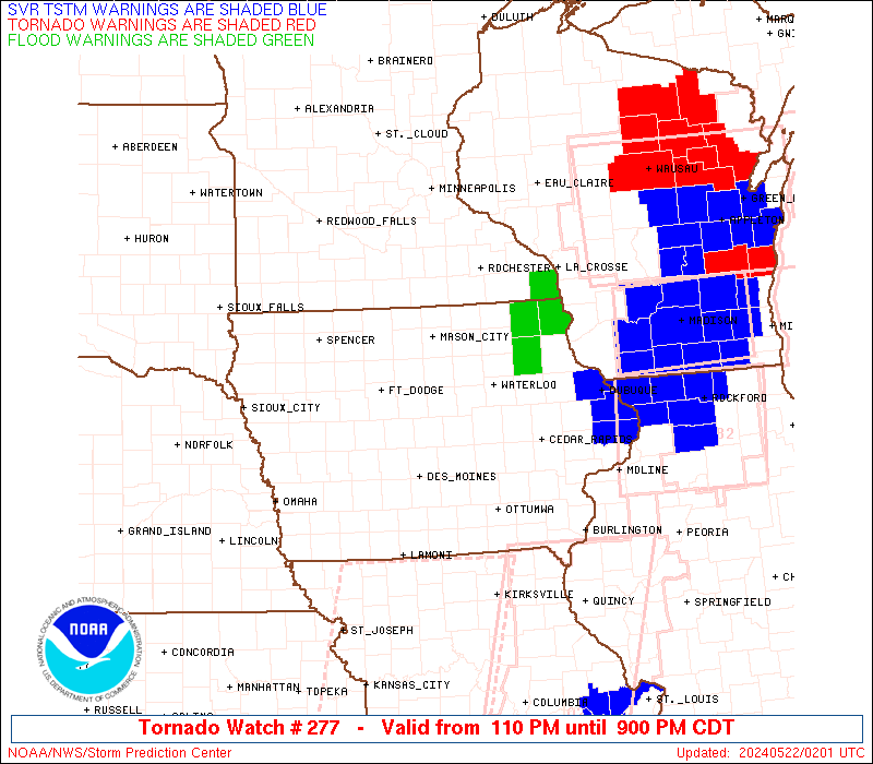
Watch 277 Status Report Messages:
STATUS REPORT #7 ON WW 277

VALID 220145Z - 220240Z

SEVERE WEATHER THREAT CONTINUES RIGHT OF A LINE FROM 35 NNE IRK
TO 25 W DBQ TO 20 N DBQ TO 15 SW VOK.

..BENTLEY..05/22/24

ATTN...WFO...DMX...ARX...DVN...MPX...

&&

STATUS REPORT FOR WT 277

SEVERE WEATHER THREAT CONTINUES FOR THE FOLLOWING AREAS

ILC015-071-073-085-131-161-187-195-220240-

IL
.    ILLINOIS COUNTIES INCLUDED ARE

CARROLL 	     HENDERSON		 HENRY
JO DAVIESS	     MERCER		 ROCK ISLAND
WARREN		     WHITESIDE
$$


IAC031-045-057-061-087-097-103-105-111-115-139-163-183-220240-

IA
.    IOWA COUNTIES INCLUDED ARE

CEDAR		     CLINTON		 DES MOINES
DUBUQUE 	     HENRY		 JACKSON
JOHNSON 	     JONES		 LEE
LOUISA		     MUSCATINE		 SCOTT
WASHINGTON
$$


WIC103-220240-

WI
.    WISCONSIN COUNTIES INCLUDED ARE

RICHLAND
$$


THE WATCH STATUS MESSAGE IS FOR GUIDANCE PURPOSES ONLY.  PLEASE
REFER TO WATCH COUNTY NOTIFICATION STATEMENTS FOR OFFICIAL
INFORMATION ON COUNTIES...INDEPENDENT CITIES AND MARINE ZONES
CLEARED FROM SEVERE THUNDERSTORM AND TORNADO WATCHES.
$$

STATUS REPORT #6 ON WW 277

VALID 220030Z - 220140Z

SEVERE WEATHER THREAT CONTINUES RIGHT OF A LINE FROM 35 NNW IRK
TO 40 S LSE TO 35 ESE EAU TO 30 E EAU.

..HART..05/22/24

ATTN...WFO...DMX...ARX...DVN...MPX...

&&

STATUS REPORT FOR WT 277

SEVERE WEATHER THREAT CONTINUES FOR THE FOLLOWING AREAS

ILC015-071-073-085-131-161-187-195-220140-

IL
.    ILLINOIS COUNTIES INCLUDED ARE

CARROLL 	     HENDERSON		 HENRY
JO DAVIESS	     MERCER		 ROCK ISLAND
WARREN		     WHITESIDE
$$


IAC011-019-031-043-045-051-055-057-061-087-095-097-101-103-105-
107-111-113-115-139-163-177-179-183-220140-

IA
.    IOWA COUNTIES INCLUDED ARE

BENTON		     BUCHANAN		 CEDAR
CLAYTON 	     CLINTON		 DAVIS
DELAWARE	     DES MOINES 	 DUBUQUE
HENRY		     IOWA		 JACKSON
JEFFERSON	     JOHNSON		 JONES
KEOKUK		     LEE		 LINN
LOUISA		     MUSCATINE		 SCOTT
VAN BUREN	     WAPELLO		 WASHINGTON
$$


WIC023-043-063-103-123-220140-

WI
.    WISCONSIN COUNTIES INCLUDED ARE

CRAWFORD	     GRANT		 LA CROSSE
RICHLAND	     VERNON
$$


THE WATCH STATUS MESSAGE IS FOR GUIDANCE PURPOSES ONLY.  PLEASE
REFER TO WATCH COUNTY NOTIFICATION STATEMENTS FOR OFFICIAL
INFORMATION ON COUNTIES...INDEPENDENT CITIES AND MARINE ZONES
CLEARED FROM SEVERE THUNDERSTORM AND TORNADO WATCHES.
$$

STATUS REPORT #5 ON WW 277

VALID 212330Z - 220040Z

SEVERE WEATHER THREAT CONTINUES RIGHT OF A LINE FROM 25 E LWD TO
15 NE ALO TO 35 WNW LSE TO 40 WSW EAU.

..HART..05/21/24

ATTN...WFO...DMX...ARX...DVN...MPX...

&&

STATUS REPORT FOR WT 277

SEVERE WEATHER THREAT CONTINUES FOR THE FOLLOWING AREAS

ILC015-071-073-085-131-161-187-195-220040-

IL
.    ILLINOIS COUNTIES INCLUDED ARE

CARROLL 	     HENDERSON		 HENRY
JO DAVIESS	     MERCER		 ROCK ISLAND
WARREN		     WHITESIDE
$$


IAC005-007-011-013-017-019-031-043-045-051-055-057-061-065-087-
095-097-101-103-105-107-111-113-115-123-135-139-157-163-171-177-
179-183-185-191-220040-

IA
.    IOWA COUNTIES INCLUDED ARE

ALLAMAKEE	     APPANOOSE		 BENTON
BLACK HAWK	     BREMER		 BUCHANAN
CEDAR		     CLAYTON		 CLINTON
DAVIS		     DELAWARE		 DES MOINES
DUBUQUE 	     FAYETTE		 HENRY
IOWA		     JACKSON		 JEFFERSON
JOHNSON 	     JONES		 KEOKUK
LEE		     LINN		 LOUISA
MAHASKA 	     MONROE		 MUSCATINE
POWESHIEK	     SCOTT		 TAMA
VAN BUREN	     WAPELLO		 WASHINGTON
WAYNE		     WINNESHIEK
$$


MNC055-169-220040-

MN
.    MINNESOTA COUNTIES INCLUDED ARE

HOUSTON 	     WINONA
$$


WIC011-023-043-063-091-103-121-123-220040-

WI
.    WISCONSIN COUNTIES INCLUDED ARE

BUFFALO 	     CRAWFORD		 GRANT
LA CROSSE	     PEPIN		 RICHLAND
TREMPEALEAU	     VERNON
$$


THE WATCH STATUS MESSAGE IS FOR GUIDANCE PURPOSES ONLY.  PLEASE
REFER TO WATCH COUNTY NOTIFICATION STATEMENTS FOR OFFICIAL
INFORMATION ON COUNTIES...INDEPENDENT CITIES AND MARINE ZONES
CLEARED FROM SEVERE THUNDERSTORM AND TORNADO WATCHES.
$$

STATUS REPORT #4 ON WW 277

VALID 212250Z - 212340Z

SEVERE WEATHER THREAT CONTINUES RIGHT OF A LINE FROM 15 E LWD TO
45 SW ALO TO 15 SSW RST TO 15 ESE MSP.

..HART..05/21/24

ATTN...WFO...DMX...ARX...DVN...MPX...

&&

STATUS REPORT FOR WT 277

SEVERE WEATHER THREAT CONTINUES FOR THE FOLLOWING AREAS

ILC015-071-073-085-131-161-187-195-212340-

IL
.    ILLINOIS COUNTIES INCLUDED ARE

CARROLL 	     HENDERSON		 HENRY
JO DAVIESS	     MERCER		 ROCK ISLAND
WARREN		     WHITESIDE
$$


IAC005-007-011-013-017-019-023-031-037-043-045-051-055-057-061-
065-067-075-087-089-095-097-099-101-103-105-107-111-113-115-117-
123-125-127-135-139-157-163-171-177-179-183-185-191-212340-

IA
.    IOWA COUNTIES INCLUDED ARE

ALLAMAKEE	     APPANOOSE		 BENTON
BLACK HAWK	     BREMER		 BUCHANAN
BUTLER		     CEDAR		 CHICKASAW
CLAYTON 	     CLINTON		 DAVIS
DELAWARE	     DES MOINES 	 DUBUQUE
FAYETTE 	     FLOYD		 GRUNDY
HENRY		     HOWARD		 IOWA
JACKSON 	     JASPER		 JEFFERSON
JOHNSON 	     JONES		 KEOKUK
LEE		     LINN		 LOUISA
LUCAS		     MAHASKA		 MARION
MARSHALL	     MONROE		 MUSCATINE
POWESHIEK	     SCOTT		 TAMA
VAN BUREN	     WAPELLO		 WASHINGTON
WAYNE		     WINNESHIEK
$$


MNC045-049-055-109-157-169-212340-

MN
.    MINNESOTA COUNTIES INCLUDED ARE

FILLMORE	     GOODHUE		 HOUSTON
OLMSTED 	     WABASHA		 WINONA
$$


WIC011-023-043-063-091-103-121-123-212340-

WI
.    WISCONSIN COUNTIES INCLUDED ARE

BUFFALO 	     CRAWFORD		 GRANT
LA CROSSE	     PEPIN		 RICHLAND
TREMPEALEAU	     VERNON
$$


THE WATCH STATUS MESSAGE IS FOR GUIDANCE PURPOSES ONLY.  PLEASE
REFER TO WATCH COUNTY NOTIFICATION STATEMENTS FOR OFFICIAL
INFORMATION ON COUNTIES...INDEPENDENT CITIES AND MARINE ZONES
CLEARED FROM SEVERE THUNDERSTORM AND TORNADO WATCHES.
$$

STATUS REPORT #3 ON WW 277

VALID 212210Z - 212340Z

SEVERE WEATHER THREAT CONTINUES RIGHT OF A LINE FROM 5 ESE LWD TO
35 ESE FOD TO 35 SE MKT TO 35 NNW MKT.

..HART..05/21/24

ATTN...WFO...DMX...ARX...DVN...MPX...

&&

STATUS REPORT FOR WT 277

SEVERE WEATHER THREAT CONTINUES FOR THE FOLLOWING AREAS

ILC015-071-073-085-131-161-187-195-212340-

IL
.    ILLINOIS COUNTIES INCLUDED ARE

CARROLL 	     HENDERSON		 HENRY
JO DAVIESS	     MERCER		 ROCK ISLAND
WARREN		     WHITESIDE
$$


IAC005-007-011-013-017-019-023-031-033-037-039-043-045-051-053-
055-057-061-065-067-069-075-083-087-089-095-097-099-101-103-105-
107-111-113-115-117-123-125-127-131-135-139-153-157-163-169-171-
177-179-181-183-185-191-195-212340-

IA
.    IOWA COUNTIES INCLUDED ARE

ALLAMAKEE	     APPANOOSE		 BENTON
BLACK HAWK	     BREMER		 BUCHANAN
BUTLER		     CEDAR		 CERRO GORDO
CHICKASAW	     CLARKE		 CLAYTON
CLINTON 	     DAVIS		 DECATUR
DELAWARE	     DES MOINES 	 DUBUQUE
FAYETTE 	     FLOYD		 FRANKLIN
GRUNDY		     HARDIN		 HENRY
HOWARD		     IOWA		 JACKSON
JASPER		     JEFFERSON		 JOHNSON
JONES		     KEOKUK		 LEE
LINN		     LOUISA		 LUCAS
MAHASKA 	     MARION		 MARSHALL
MITCHELL	     MONROE		 MUSCATINE
POLK		     POWESHIEK		 SCOTT
STORY		     TAMA		 VAN BUREN
WAPELLO 	     WARREN		 WASHINGTON
WAYNE		     WINNESHIEK 	 WORTH
$$


MNC019-037-039-045-047-049-055-079-099-109-131-139-147-157-169-
212340-

MN
.    MINNESOTA COUNTIES INCLUDED ARE

CARVER		     DAKOTA		 DODGE
FILLMORE	     FREEBORN		 GOODHUE
HOUSTON 	     LE SUEUR		 MOWER
OLMSTED 	     RICE		 SCOTT
STEELE		     WABASHA		 WINONA
$$


WIC011-023-043-063-091-103-121-123-212340-

WI
.    WISCONSIN COUNTIES INCLUDED ARE

BUFFALO 	     CRAWFORD		 GRANT
LA CROSSE	     PEPIN		 RICHLAND
TREMPEALEAU	     VERNON
$$


THE WATCH STATUS MESSAGE IS FOR GUIDANCE PURPOSES ONLY.  PLEASE
REFER TO WATCH COUNTY NOTIFICATION STATEMENTS FOR OFFICIAL
INFORMATION ON COUNTIES...INDEPENDENT CITIES AND MARINE ZONES
CLEARED FROM SEVERE THUNDERSTORM AND TORNADO WATCHES.
$$

STATUS REPORT #2 ON WW 277

VALID 212140Z - 212240Z

SEVERE WEATHER THREAT CONTINUES RIGHT OF A LINE FROM 5 SSW LWD TO
15 SSE FOD TO 20 ENE FRM TO 25 ENE RWF.

..HART..05/21/24

ATTN...WFO...DMX...ARX...DVN...MPX...

&&

STATUS REPORT FOR WT 277

SEVERE WEATHER THREAT CONTINUES FOR THE FOLLOWING AREAS

ILC015-071-073-085-131-161-187-195-212240-

IL
.    ILLINOIS COUNTIES INCLUDED ARE

CARROLL 	     HENDERSON		 HENRY
JO DAVIESS	     MERCER		 ROCK ISLAND
WARREN		     WHITESIDE
$$


IAC005-007-011-013-015-017-019-023-031-033-037-039-043-045-051-
053-055-057-061-065-067-069-075-079-081-083-087-089-095-097-099-
101-103-105-107-111-113-115-117-121-123-125-127-131-135-139-153-
157-163-169-171-177-179-181-183-185-187-189-191-195-197-
212240-

IA
.    IOWA COUNTIES INCLUDED ARE

ALLAMAKEE	     APPANOOSE		 BENTON
BLACK HAWK	     BOONE		 BREMER
BUCHANAN	     BUTLER		 CEDAR
CERRO GORDO	     CHICKASAW		 CLARKE
CLAYTON 	     CLINTON		 DAVIS
DECATUR 	     DELAWARE		 DES MOINES
DUBUQUE 	     FAYETTE		 FLOYD
FRANKLIN	     GRUNDY		 HAMILTON
HANCOCK 	     HARDIN		 HENRY
HOWARD		     IOWA		 JACKSON
JASPER		     JEFFERSON		 JOHNSON
JONES		     KEOKUK		 LEE
LINN		     LOUISA		 LUCAS
MADISON 	     MAHASKA		 MARION
MARSHALL	     MITCHELL		 MONROE
MUSCATINE	     POLK		 POWESHIEK
SCOTT		     STORY		 TAMA
VAN BUREN	     WAPELLO		 WARREN
WASHINGTON	     WAYNE		 WEBSTER
WINNEBAGO	     WINNESHIEK 	 WORTH
WRIGHT
$$


MNC013-019-037-039-043-045-047-049-055-079-099-103-109-131-139-
143-147-157-161-169-212240-

MN
.    MINNESOTA COUNTIES INCLUDED ARE

BLUE EARTH	     CARVER		 DAKOTA
DODGE		     FARIBAULT		 FILLMORE
FREEBORN	     GOODHUE		 HOUSTON
LE SUEUR	     MOWER		 NICOLLET
OLMSTED 	     RICE		 SCOTT
SIBLEY		     STEELE		 WABASHA
WASECA		     WINONA
$$


WIC011-023-043-063-091-103-121-123-212240-

WI
.    WISCONSIN COUNTIES INCLUDED ARE

BUFFALO 	     CRAWFORD		 GRANT
LA CROSSE	     PEPIN		 RICHLAND
TREMPEALEAU	     VERNON
$$


THE WATCH STATUS MESSAGE IS FOR GUIDANCE PURPOSES ONLY.  PLEASE
REFER TO WATCH COUNTY NOTIFICATION STATEMENTS FOR OFFICIAL
INFORMATION ON COUNTIES...INDEPENDENT CITIES AND MARINE ZONES
CLEARED FROM SEVERE THUNDERSTORM AND TORNADO WATCHES.
$$

STATUS REPORT #1 ON WW 277

VALID 212100Z - 212240Z

SEVERE WEATHER THREAT CONTINUES RIGHT OF A LINE FROM 20 W LWD TO
40 E DNS TO 10 S FRM TO 20 NE RWF.

..HART..05/21/24

ATTN...WFO...DMX...ARX...DVN...MPX...

&&

STATUS REPORT FOR WT 277

SEVERE WEATHER THREAT CONTINUES FOR THE FOLLOWING AREAS

ILC015-071-073-085-131-161-187-195-212240-

IL
.    ILLINOIS COUNTIES INCLUDED ARE

CARROLL 	     HENDERSON		 HENRY
JO DAVIESS	     MERCER		 ROCK ISLAND
WARREN		     WHITESIDE
$$


IAC001-005-007-011-013-015-017-019-023-031-033-037-039-043-045-
049-051-053-055-057-061-065-067-069-073-075-077-079-081-083-087-
089-091-095-097-099-101-103-105-107-109-111-113-115-117-121-123-
125-127-131-135-139-153-157-159-163-169-171-175-177-179-181-183-
185-187-189-191-195-197-212240-

IA
.    IOWA COUNTIES INCLUDED ARE

ADAIR		     ALLAMAKEE		 APPANOOSE
BENTON		     BLACK HAWK 	 BOONE
BREMER		     BUCHANAN		 BUTLER
CEDAR		     CERRO GORDO	 CHICKASAW
CLARKE		     CLAYTON		 CLINTON
DALLAS		     DAVIS		 DECATUR
DELAWARE	     DES MOINES 	 DUBUQUE
FAYETTE 	     FLOYD		 FRANKLIN
GREENE		     GRUNDY		 GUTHRIE
HAMILTON	     HANCOCK		 HARDIN
HENRY		     HOWARD		 HUMBOLDT
IOWA		     JACKSON		 JASPER
JEFFERSON	     JOHNSON		 JONES
KEOKUK		     KOSSUTH		 LEE
LINN		     LOUISA		 LUCAS
MADISON 	     MAHASKA		 MARION
MARSHALL	     MITCHELL		 MONROE
MUSCATINE	     POLK		 POWESHIEK
RINGGOLD	     SCOTT		 STORY
TAMA		     UNION		 VAN BUREN
WAPELLO 	     WARREN		 WASHINGTON
WAYNE		     WEBSTER		 WINNEBAGO
WINNESHIEK	     WORTH		 WRIGHT
$$


MNC013-019-037-039-043-045-047-049-055-079-091-099-103-109-131-
139-143-147-157-161-165-169-212240-

MN
.    MINNESOTA COUNTIES INCLUDED ARE

BLUE EARTH	     CARVER		 DAKOTA
DODGE		     FARIBAULT		 FILLMORE
FREEBORN	     GOODHUE		 HOUSTON
LE SUEUR	     MARTIN		 MOWER
NICOLLET	     OLMSTED		 RICE
SCOTT		     SIBLEY		 STEELE
WABASHA 	     WASECA		 WATONWAN
WINONA
$$


WIC011-091-121-212240-

WI
.    WISCONSIN COUNTIES INCLUDED ARE

BUFFALO 	     PEPIN		 TREMPEALEAU
$$


THE WATCH STATUS MESSAGE IS FOR GUIDANCE PURPOSES ONLY.  PLEASE
REFER TO WATCH COUNTY NOTIFICATION STATEMENTS FOR OFFICIAL
INFORMATION ON COUNTIES...INDEPENDENT CITIES AND MARINE ZONES
CLEARED FROM SEVERE THUNDERSTORM AND TORNADO WATCHES.
$$
Note:
Click for Complete Product Text.
Tornadoes
Probability of 2 or more tornadoes
|
High (90%)
|
Probability of 1 or more strong (EF2-EF5) tornadoes
|
High (80%)
|
Wind
Probability of 10 or more severe wind events
|
High (80%)
|
Probability of 1 or more wind events > 65 knots
|
Mod (60%)
|
Hail
Probability of 10 or more severe hail events
|
Mod (60%)
|
Probability of 1 or more hailstones > 2 inches
|
Mod (50%)
|
Combined Severe Hail/Wind
Probability of 6 or more combined severe hail/wind events
|
High (>95%)
|
For each watch, probabilities for particular events inside the watch
(listed above in each table) are determined by the issuing forecaster.
The "Low" category contains probability values ranging from less than 2%
to 20% (EF2-EF5 tornadoes), less than 5% to 20% (all other probabilities),
"Moderate" from 30% to 60%, and "High" from 70% to greater than 95%.
High values are bolded and lighter in color to provide awareness of
an increased threat for a particular event.


 @NWSSPC