 Note:
The expiration time in the watch graphic is amended if the watch is
replaced, cancelled or extended.
Note:
Note:
The expiration time in the watch graphic is amended if the watch is
replaced, cancelled or extended.
Note: Click for
Watch Status Reports.
SEL2
URGENT - IMMEDIATE BROADCAST REQUESTED
Tornado Watch Number 172
NWS Storm Prediction Center Norman OK
455 PM CDT Wed May 1 2024
The NWS Storm Prediction Center has issued a
* Tornado Watch for portions of
Western and central Kansas
* Effective this Wednesday afternoon from 455 PM until Midnight
CDT.
* Primary threats include...
A couple tornadoes possible
Scattered large hail likely with isolated very large hail events
to 3.5 inches in diameter possible
Scattered damaging wind gusts to 70 mph possible
SUMMARY...At least isolated severe storms including supercells are
expected to develop through early evening, initially near a surface
low and dryline and warm/nearly stationary front across western
Kansas. Even if storms remain relatively isolated, they will be
capable of very large hail, tornadoes, and very strong wind gusts.
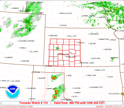
The tornado watch area is approximately along and 60 statute miles
north and south of a line from 40 miles west of Garden City KS to 55
miles south southeast of Russell KS. For a complete depiction of the
watch see the associated watch outline update (WOUS64 KWNS WOU2).
PRECAUTIONARY/PREPAREDNESS ACTIONS...
REMEMBER...A Tornado Watch means conditions are favorable for
tornadoes and severe thunderstorms in and close to the watch
area. Persons in these areas should be on the lookout for
threatening weather conditions and listen for later statements
and possible warnings.
&&
OTHER WATCH INFORMATION...CONTINUE...WW 170...WW 171...
AVIATION...Tornadoes and a few severe thunderstorms with hail
surface and aloft to 3.5 inches. Extreme turbulence and surface wind
gusts to 60 knots. A few cumulonimbi with maximum tops to 500. Mean
storm motion vector 24025.
...Guyer

   SEL2

   URGENT - IMMEDIATE BROADCAST REQUESTED
   Tornado Watch Number 172
   NWS Storm Prediction Center Norman OK
   455 PM CDT Wed May 1 2024

   The NWS Storm Prediction Center has issued a

   * Tornado Watch for portions of
     Western and central Kansas

   * Effective this Wednesday afternoon from 455 PM until Midnight
     CDT.

   * Primary threats include...
     A couple tornadoes possible
     Scattered large hail likely with isolated very large hail events
       to 3.5 inches in diameter possible
     Scattered damaging wind gusts to 70 mph possible

   SUMMARY...At least isolated severe storms including supercells are
   expected to develop through early evening, initially near a surface
   low and dryline and warm/nearly stationary front across western
   Kansas. Even if storms remain relatively isolated, they will be
   capable of very large hail, tornadoes, and very strong wind gusts.

   The tornado watch area is approximately along and 60 statute miles
   north and south of a line from 40 miles west of Garden City KS to 55
   miles south southeast of Russell KS. For a complete depiction of the
   watch see the associated watch outline update (WOUS64 KWNS WOU2).

   PRECAUTIONARY/PREPAREDNESS ACTIONS...

   REMEMBER...A Tornado Watch means conditions are favorable for
   tornadoes and severe thunderstorms in and close to the watch
   area. Persons in these areas should be on the lookout for
   threatening weather conditions and listen for later statements
   and possible warnings.

   &&

   OTHER WATCH INFORMATION...CONTINUE...WW 170...WW 171...

   AVIATION...Tornadoes and a few severe thunderstorms with hail
   surface and aloft to 3.5 inches. Extreme turbulence and surface wind
   gusts to 60 knots. A few cumulonimbi with maximum tops to 500. Mean
   storm motion vector 24025.

   ...Guyer
 Note:
The Aviation Watch (SAW) product is an approximation to the watch area.
The actual watch is depicted by the shaded areas.
Note:
The Aviation Watch (SAW) product is an approximation to the watch area.
The actual watch is depicted by the shaded areas.
   SAW2
   WW 172 TORNADO KS 012155Z - 020500Z
   AXIS..60 STATUTE MILES NORTH AND SOUTH OF LINE..
   40W GCK/GARDEN CITY KS/ - 55SSE RSL/RUSSELL KS/
   ..AVIATION COORDS.. 50NM N/S /34W GCK - 46WNW ICT/
   HAIL SURFACE AND ALOFT..3.5 INCHES. WIND GUSTS..60 KNOTS.
   MAX TOPS TO 500. MEAN STORM MOTION VECTOR 24025.

   LAT...LON 38800145 38999843 37259843 37060145

   THIS IS AN APPROXIMATION TO THE WATCH AREA.  FOR A
   COMPLETE DEPICTION OF THE WATCH SEE WOUS64 KWNS
   FOR WOU2.
Watch 172 Status Report Messages:
STATUS REPORT #2 ON WW 172

VALID 020230Z - 020340Z

SEVERE WEATHER THREAT CONTINUES RIGHT OF A LINE FROM 30 WNW HUT
TO 45 WNW GCK.

..MOSIER..05/02/24

ATTN...WFO...DDC...ICT...GLD...

&&

STATUS REPORT FOR WT 172

SEVERE WEATHER THREAT CONTINUES FOR THE FOLLOWING AREAS

KSC009-051-063-101-109-135-165-167-171-195-203-020340-

KS
.    KANSAS COUNTIES INCLUDED ARE

BARTON		     ELLIS		 GOVE
LANE		     LOGAN		 NESS
RUSH		     RUSSELL		 SCOTT
TREGO		     WICHITA
$$


THE WATCH STATUS MESSAGE IS FOR GUIDANCE PURPOSES ONLY.  PLEASE
REFER TO WATCH COUNTY NOTIFICATION STATEMENTS FOR OFFICIAL
INFORMATION ON COUNTIES...INDEPENDENT CITIES AND MARINE ZONES
CLEARED FROM SEVERE THUNDERSTORM AND TORNADO WATCHES.
$$

STATUS REPORT #1 ON WW 172

VALID 020055Z - 020140Z

THE SEVERE WEATHER THREAT CONTINUES ACROSS THE ENTIRE WATCH AREA.

..SQUITIERI..05/02/24

ATTN...WFO...DDC...ICT...GLD...

&&

STATUS REPORT FOR WT 172

SEVERE WEATHER THREAT CONTINUES FOR THE FOLLOWING AREAS

KSC007-009-025-033-047-051-055-057-063-067-069-081-083-093-097-
101-109-119-135-145-151-165-167-171-175-185-189-195-203-
020140-

KS
.    KANSAS COUNTIES INCLUDED ARE

BARBER		     BARTON		 CLARK
COMANCHE	     EDWARDS		 ELLIS
FINNEY		     FORD		 GOVE
GRANT		     GRAY		 HASKELL
HODGEMAN	     KEARNY		 KIOWA
LANE		     LOGAN		 MEADE
NESS		     PAWNEE		 PRATT
RUSH		     RUSSELL		 SCOTT
SEWARD		     STAFFORD		 STEVENS
TREGO		     WICHITA
$$


THE WATCH STATUS MESSAGE IS FOR GUIDANCE PURPOSES ONLY.  PLEASE
REFER TO WATCH COUNTY NOTIFICATION STATEMENTS FOR OFFICIAL
INFORMATION ON COUNTIES...INDEPENDENT CITIES AND MARINE ZONES
CLEARED FROM SEVERE THUNDERSTORM AND TORNADO WATCHES.
$$
Note:
Click for Complete Product Text.
Tornadoes
Probability of 2 or more tornadoes
|
Mod (40%)
|
Probability of 1 or more strong (EF2-EF5) tornadoes
|
Low (20%)
|
Wind
Probability of 10 or more severe wind events
|
Mod (50%)
|
Probability of 1 or more wind events > 65 knots
|
Low (20%)
|
Hail
Probability of 10 or more severe hail events
|
High (70%)
|
Probability of 1 or more hailstones > 2 inches
|
Mod (50%)
|
Combined Severe Hail/Wind
Probability of 6 or more combined severe hail/wind events
|
High (90%)
|
For each watch, probabilities for particular events inside the watch
(listed above in each table) are determined by the issuing forecaster.
The "Low" category contains probability values ranging from less than 2%
to 20% (EF2-EF5 tornadoes), less than 5% to 20% (all other probabilities),
"Moderate" from 30% to 60%, and "High" from 70% to greater than 95%.
High values are bolded and lighter in color to provide awareness of
an increased threat for a particular event.


 @NWSSPC


