 Note:
The expiration time in the watch graphic is amended if the watch is
replaced, cancelled or extended.
Note:
Note:
The expiration time in the watch graphic is amended if the watch is
replaced, cancelled or extended.
Note: Click for
Watch Status Reports.
SEL2
URGENT - IMMEDIATE BROADCAST REQUESTED
Tornado Watch Number 152
NWS Storm Prediction Center Norman OK
1130 PM CDT Sat Apr 19 2025
The NWS Storm Prediction Center has issued a
* Tornado Watch for portions of
West-Central and Northwest Arkansas
Eastern and Southeast Oklahoma
Central and North Texas
* Effective this Saturday night and Sunday morning from 1130 PM
until 700 AM CDT.
* Primary threats include...
A few tornadoes and a couple intense tornadoes possible
Scattered damaging wind gusts to 70 mph likely
Scattered large hail events to 1.5 inches in diameter possible
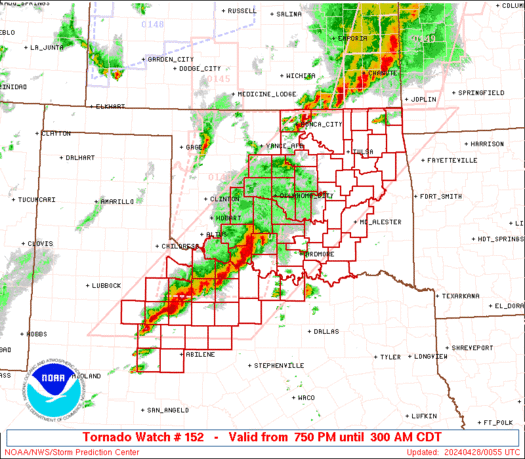
SUMMARY...A broken band of strong to severe thunderstorms will
continue to progress east-northeast across the Watch area tonight.
The severe risk, including the potential for a few tornadoes, will
likely focus with supercells and bowing line segments. A strong
tornado or two remains possible due to a moist and strongly sheared
environment expected to persist through tonight.
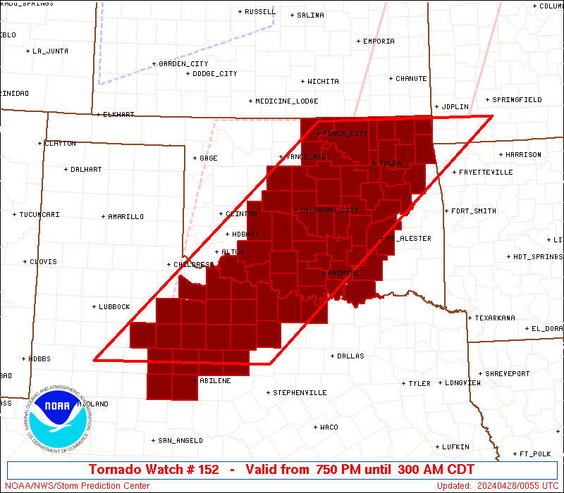
The tornado watch area is approximately along and 60 statute miles
east and west of a line from 35 miles west northwest of Harrison AR
to 25 miles east southeast of Brownwood TX. For a complete depiction
of the watch see the associated watch outline update (WOUS64 KWNS
WOU2).
PRECAUTIONARY/PREPAREDNESS ACTIONS...
REMEMBER...A Tornado Watch means conditions are favorable for
tornadoes and severe thunderstorms in and close to the watch
area. Persons in these areas should be on the lookout for
threatening weather conditions and listen for later statements
and possible warnings.
&&
OTHER WATCH INFORMATION...CONTINUE...WW 149...WW 150...WW 151...
AVIATION...Tornadoes and a few severe thunderstorms with hail
surface and aloft to 1.5 inches. Extreme turbulence and surface wind
gusts to 60 knots. A few cumulonimbi with maximum tops to 500. Mean
storm motion vector 24035.
...Smith

   SEL2

   URGENT - IMMEDIATE BROADCAST REQUESTED
   Tornado Watch Number 152
   NWS Storm Prediction Center Norman OK
   1130 PM CDT Sat Apr 19 2025

   The NWS Storm Prediction Center has issued a

   * Tornado Watch for portions of
     West-Central and Northwest Arkansas
     Eastern and Southeast Oklahoma
     Central and North Texas

   * Effective this Saturday night and Sunday morning from 1130 PM
     until 700 AM CDT.

   * Primary threats include...
     A few tornadoes and a couple intense tornadoes possible
     Scattered damaging wind gusts to 70 mph likely
     Scattered large hail events to 1.5 inches in diameter possible

   SUMMARY...A broken band of strong to severe thunderstorms will
   continue to progress east-northeast across the Watch area tonight.
   The severe risk, including the potential for a few tornadoes, will
   likely focus with supercells and bowing line segments.  A strong
   tornado or two remains possible due to a moist and strongly sheared
   environment expected to persist through tonight.

   The tornado watch area is approximately along and 60 statute miles
   east and west of a line from 35 miles west northwest of Harrison AR
   to 25 miles east southeast of Brownwood TX. For a complete depiction
   of the watch see the associated watch outline update (WOUS64 KWNS
   WOU2).

   PRECAUTIONARY/PREPAREDNESS ACTIONS...

   REMEMBER...A Tornado Watch means conditions are favorable for
   tornadoes and severe thunderstorms in and close to the watch
   area. Persons in these areas should be on the lookout for
   threatening weather conditions and listen for later statements
   and possible warnings.

   &&

   OTHER WATCH INFORMATION...CONTINUE...WW 149...WW 150...WW 151...

   AVIATION...Tornadoes and a few severe thunderstorms with hail
   surface and aloft to 1.5 inches. Extreme turbulence and surface wind
   gusts to 60 knots. A few cumulonimbi with maximum tops to 500. Mean
   storm motion vector 24035.

   ...Smith
 Note:
The Aviation Watch (SAW) product is an approximation to the watch area.
The actual watch is depicted by the shaded areas.
Note:
The Aviation Watch (SAW) product is an approximation to the watch area.
The actual watch is depicted by the shaded areas.
   SAW2
   WW 152 TORNADO AR OK TX 200430Z - 201200Z
   AXIS..60 STATUTE MILES EAST AND WEST OF LINE..
   35WNW HRO/HARRISON AR/ - 25ESE BWD/BROWNWOOD TX/
   ..AVIATION COORDS.. 50NM E/W /23NE RZC - 66W ACT/
   HAIL SURFACE AND ALOFT..1.5 INCHES. WIND GUSTS..60 KNOTS.
   MAX TOPS TO 500. MEAN STORM MOTION VECTOR 24035.

   LAT...LON 36469265 31669754 31669958 36469481

   THIS IS AN APPROXIMATION TO THE WATCH AREA.  FOR A
   COMPLETE DEPICTION OF THE WATCH SEE WOUS64 KWNS
   FOR WOU2.
Watch 152 Status Report Messages:
STATUS REPORT #4 ON WW 152

VALID 200935Z - 201040Z

SEVERE WEATHER THREAT CONTINUES RIGHT OF A LINE FROM 25 N DEQ TO
35 SSE MLC TO 15 ESE DUA TO 10 N GYI TO 35 NNE DUA TO 10 ESE MLC
TO 15 SE RKR TO 40 ESE FYV TO 20 S UMN.

..BROYLES..04/20/25

ATTN...WFO...TSA...LZK...OUN...FWD...

&&

STATUS REPORT FOR WT 152

SEVERE WEATHER THREAT CONTINUES FOR THE FOLLOWING AREAS

ARC009-015-071-083-101-127-201040-

AR
.    ARKANSAS COUNTIES INCLUDED ARE

BOONE		     CARROLL		 JOHNSON
LOGAN		     NEWTON		 SCOTT
$$


OKC005-013-201040-

OK
.    OKLAHOMA COUNTIES INCLUDED ARE

ATOKA		     BRYAN
$$


THE WATCH STATUS MESSAGE IS FOR GUIDANCE PURPOSES ONLY.  PLEASE
REFER TO WATCH COUNTY NOTIFICATION STATEMENTS FOR OFFICIAL
INFORMATION ON COUNTIES...INDEPENDENT CITIES AND MARINE ZONES
CLEARED FROM SEVERE THUNDERSTORM AND TORNADO WATCHES.
$$

STATUS REPORT #3 ON WW 152

VALID 200900Z - 201040Z

SEVERE WEATHER THREAT CONTINUES RIGHT OF A LINE FROM 25 ESE BWD
TO 35 E SEP TO 40 N FTW TO 20 SW MLC TO 35 WSW MKO.

..GLEASON..04/20/25

ATTN...WFO...TSA...LZK...OUN...FWD...

&&

STATUS REPORT FOR WT 152

SEVERE WEATHER THREAT CONTINUES FOR THE FOLLOWING AREAS

ARC007-009-015-033-047-071-083-087-101-127-131-143-201040-

AR
.    ARKANSAS COUNTIES INCLUDED ARE

BENTON		     BOONE		 CARROLL
CRAWFORD	     FRANKLIN		 JOHNSON
LOGAN		     MADISON		 NEWTON
SCOTT		     SEBASTIAN		 WASHINGTON
$$


OKC001-005-013-021-023-061-077-079-091-101-121-127-135-201040-

OK
.    OKLAHOMA COUNTIES INCLUDED ARE

ADAIR		     ATOKA		 BRYAN
CHEROKEE	     CHOCTAW		 HASKELL
LATIMER 	     LE FLORE		 MCINTOSH
MUSKOGEE	     PITTSBURG		 PUSHMATAHA
SEQUOYAH
$$


TXC035-085-097-113-121-147-181-193-251-333-439-201040-

TX
.    TEXAS COUNTIES INCLUDED ARE

BOSQUE		     COLLIN		 COOKE
DALLAS		     DENTON		 FANNIN
GRAYSON 	     HAMILTON		 JOHNSON
MILLS		     TARRANT
$$


THE WATCH STATUS MESSAGE IS FOR GUIDANCE PURPOSES ONLY.  PLEASE
REFER TO WATCH COUNTY NOTIFICATION STATEMENTS FOR OFFICIAL
INFORMATION ON COUNTIES...INDEPENDENT CITIES AND MARINE ZONES
CLEARED FROM SEVERE THUNDERSTORM AND TORNADO WATCHES.
$$

STATUS REPORT #2 ON WW 152

VALID 200655Z - 200740Z

THE SEVERE WEATHER THREAT CONTINUES ACROSS THE ENTIRE WATCH AREA.

FOR ADDITIONAL INFORMATION SEE MESOSCALE DISCUSSION 498

..GLEASON..04/20/25

ATTN...WFO...TSA...LZK...OUN...FWD...

&&

STATUS REPORT FOR WT 152

SEVERE WEATHER THREAT CONTINUES FOR THE FOLLOWING AREAS

ARC007-009-015-033-047-071-083-087-101-127-131-143-200740-

AR
.    ARKANSAS COUNTIES INCLUDED ARE

BENTON		     BOONE		 CARROLL
CRAWFORD	     FRANKLIN		 JOHNSON
LOGAN		     MADISON		 NEWTON
SCOTT		     SEBASTIAN		 WASHINGTON
$$


OKC001-005-013-021-023-029-041-061-063-069-077-079-091-095-097-
101-107-111-121-127-135-145-200740-

OK
.    OKLAHOMA COUNTIES INCLUDED ARE

ADAIR		     ATOKA		 BRYAN
CHEROKEE	     CHOCTAW		 COAL
DELAWARE	     HASKELL		 HUGHES
JOHNSTON	     LATIMER		 LE FLORE
MCINTOSH	     MARSHALL		 MAYES
MUSKOGEE	     OKFUSKEE		 OKMULGEE
PITTSBURG	     PUSHMATAHA 	 SEQUOYAH
WAGONER
$$


TXC035-085-093-097-113-121-133-143-147-181-193-221-237-251-333-
337-363-367-425-439-497-200740-

TX
.    TEXAS COUNTIES INCLUDED ARE

BOSQUE		     COLLIN		 COMANCHE
COOKE		     DALLAS		 DENTON
EASTLAND	     ERATH		 FANNIN
GRAYSON 	     HAMILTON		 HOOD
JACK		     JOHNSON		 MILLS
MONTAGUE	     PALO PINTO 	 PARKER
SOMERVELL	     TARRANT		 WISE
$$


THE WATCH STATUS MESSAGE IS FOR GUIDANCE PURPOSES ONLY.  PLEASE
REFER TO WATCH COUNTY NOTIFICATION STATEMENTS FOR OFFICIAL
INFORMATION ON COUNTIES...INDEPENDENT CITIES AND MARINE ZONES
CLEARED FROM SEVERE THUNDERSTORM AND TORNADO WATCHES.
$$

STATUS REPORT #1 ON WW 152

VALID 200540Z - 200640Z

THE SEVERE WEATHER THREAT CONTINUES ACROSS THE ENTIRE WATCH AREA.

..BROYLES..04/20/25

ATTN...WFO...TSA...LZK...OUN...FWD...

&&

STATUS REPORT FOR WT 152

SEVERE WEATHER THREAT CONTINUES FOR THE FOLLOWING AREAS

ARC007-009-015-033-047-071-083-087-101-127-131-143-200640-

AR
.    ARKANSAS COUNTIES INCLUDED ARE

BENTON		     BOONE		 CARROLL
CRAWFORD	     FRANKLIN		 JOHNSON
LOGAN		     MADISON		 NEWTON
SCOTT		     SEBASTIAN		 WASHINGTON
$$


OKC001-005-013-021-023-029-041-061-063-069-077-079-091-095-097-
101-107-111-121-127-135-145-200640-

OK
.    OKLAHOMA COUNTIES INCLUDED ARE

ADAIR		     ATOKA		 BRYAN
CHEROKEE	     CHOCTAW		 COAL
DELAWARE	     HASKELL		 HUGHES
JOHNSTON	     LATIMER		 LE FLORE
MCINTOSH	     MARSHALL		 MAYES
MUSKOGEE	     OKFUSKEE		 OKMULGEE
PITTSBURG	     PUSHMATAHA 	 SEQUOYAH
WAGONER
$$


TXC035-085-093-097-113-121-133-143-147-181-193-221-237-251-333-
337-363-367-425-439-497-200640-

TX
.    TEXAS COUNTIES INCLUDED ARE

BOSQUE		     COLLIN		 COMANCHE
COOKE		     DALLAS		 DENTON
EASTLAND	     ERATH		 FANNIN
GRAYSON 	     HAMILTON		 HOOD
JACK		     JOHNSON		 MILLS
MONTAGUE	     PALO PINTO 	 PARKER
SOMERVELL	     TARRANT		 WISE
$$


THE WATCH STATUS MESSAGE IS FOR GUIDANCE PURPOSES ONLY.  PLEASE
REFER TO WATCH COUNTY NOTIFICATION STATEMENTS FOR OFFICIAL
INFORMATION ON COUNTIES...INDEPENDENT CITIES AND MARINE ZONES
CLEARED FROM SEVERE THUNDERSTORM AND TORNADO WATCHES.
$$
Note:
Click for Complete Product Text.
Tornadoes
Probability of 2 or more tornadoes
|
Mod (50%)
|
Probability of 1 or more strong (EF2-EF5) tornadoes
|
Mod (30%)
|
Wind
Probability of 10 or more severe wind events
|
Mod (60%)
|
Probability of 1 or more wind events > 65 knots
|
Low (20%)
|
Hail
Probability of 10 or more severe hail events
|
Mod (40%)
|
Probability of 1 or more hailstones > 2 inches
|
Low (10%)
|
Combined Severe Hail/Wind
Probability of 6 or more combined severe hail/wind events
|
High (90%)
|
For each watch, probabilities for particular events inside the watch
(listed above in each table) are determined by the issuing forecaster.
The "Low" category contains probability values ranging from less than 2%
to 20% (EF2-EF5 tornadoes), less than 5% to 20% (all other probabilities),
"Moderate" from 30% to 60%, and "High" from 70% to greater than 95%.
High values are bolded and lighter in color to provide awareness of
an increased threat for a particular event.


 @NWSSPC