 Note:
The expiration time in the watch graphic is amended if the watch is
replaced, cancelled or extended.
Note:
Note:
The expiration time in the watch graphic is amended if the watch is
replaced, cancelled or extended.
Note: Click for
Watch Status Reports.
SEL2
URGENT - IMMEDIATE BROADCAST REQUESTED
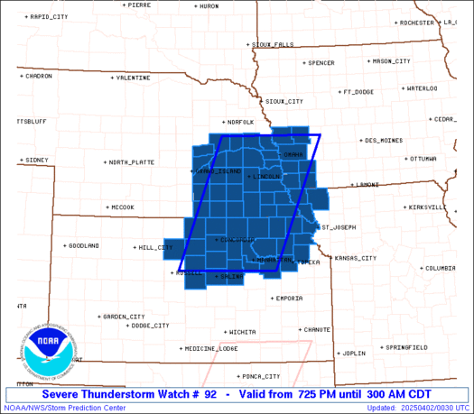
Severe Thunderstorm Watch Number 92
NWS Storm Prediction Center Norman OK
725 PM CDT Tue Apr 1 2025
The NWS Storm Prediction Center has issued a
* Severe Thunderstorm Watch for portions of
Far Southwest Iowa
Northeast Kansas
Far Northwest Missouri
Southeast Nebraska
* Effective this Tuesday night and Wednesday morning from 725 PM
until 300 AM CDT.
* Primary threats include...
Scattered large hail and isolated very large hail events to 2.5
inches in diameter likely
Scattered damaging winds likely with isolated significant gusts
to 80 mph possible
A tornado or two possible
SUMMARY...Thunderstorm coverage is expected to increase over the
next few hours as a surface low and associated cold front move into
the region. Environment conditions support the potential for strong
to severe thunderstorms capable of large to very large hail and
strong wind gusts. A limited, but non-zero, tornado threat could
materialize across portions of northeast KS.
The severe thunderstorm watch area is approximately along and 70
statute miles east and west of a line from 30 miles north northwest
of Omaha NE to 40 miles west southwest of Manhattan KS. For a
complete depiction of the watch see the associated watch outline
update (WOUS64 KWNS WOU2).
PRECAUTIONARY/PREPAREDNESS ACTIONS...
REMEMBER...A Severe Thunderstorm Watch means conditions are
favorable for severe thunderstorms in and close to the watch area.
Persons in these areas should be on the lookout for threatening
weather conditions and listen for later statements and possible
warnings. Severe thunderstorms can and occasionally do produce
tornadoes.
&&
OTHER WATCH INFORMATION...CONTINUE...WW 91...
AVIATION...A few severe thunderstorms with hail surface and aloft to
2.5 inches. Extreme turbulence and surface wind gusts to 70 knots. A
few cumulonimbi with maximum tops to 500. Mean storm motion vector
24035.
...Mosier

   SEL2

   URGENT - IMMEDIATE BROADCAST REQUESTED
   Severe Thunderstorm Watch Number 92
   NWS Storm Prediction Center Norman OK
   725 PM CDT Tue Apr 1 2025

   The NWS Storm Prediction Center has issued a

   * Severe Thunderstorm Watch for portions of
     Far Southwest Iowa
     Northeast Kansas
     Far Northwest Missouri
     Southeast Nebraska

   * Effective this Tuesday night and Wednesday morning from 725 PM
     until 300 AM CDT.

   * Primary threats include...
     Scattered large hail and isolated very large hail events to 2.5
       inches in diameter likely
     Scattered damaging winds likely with isolated significant gusts
       to 80 mph possible
     A tornado or two possible

   SUMMARY...Thunderstorm coverage is expected to increase over the
   next few hours as a surface low and associated cold front move into
   the region. Environment conditions support the potential for strong
   to severe thunderstorms capable of large to very large hail and
   strong wind gusts. A limited, but non-zero, tornado threat could
   materialize across portions of northeast KS.

   The severe thunderstorm watch area is approximately along and 70
   statute miles east and west of a line from 30 miles north northwest
   of Omaha NE to 40 miles west southwest of Manhattan KS. For a
   complete depiction of the watch see the associated watch outline
   update (WOUS64 KWNS WOU2).

   PRECAUTIONARY/PREPAREDNESS ACTIONS...

   REMEMBER...A Severe Thunderstorm Watch means conditions are
   favorable for severe thunderstorms in and close to the watch area.
   Persons in these areas should be on the lookout for threatening
   weather conditions and listen for later statements and possible
   warnings. Severe thunderstorms can and occasionally do produce
   tornadoes.

   &&

   OTHER WATCH INFORMATION...CONTINUE...WW 91...

   AVIATION...A few severe thunderstorms with hail surface and aloft to
   2.5 inches. Extreme turbulence and surface wind gusts to 70 knots. A
   few cumulonimbi with maximum tops to 500. Mean storm motion vector
   24035.

   ...Mosier
 Note:
The Aviation Watch (SAW) product is an approximation to the watch area.
The actual watch is depicted by the shaded areas.
Note:
The Aviation Watch (SAW) product is an approximation to the watch area.
The actual watch is depicted by the shaded areas.
   SAW2
   WW 92 SEVERE TSTM IA KS MO NE 020025Z - 020800Z
   AXIS..70 STATUTE MILES EAST AND WEST OF LINE..
   30NNW OMA/OMAHA NE/ - 40WSW MHK/MANHATTAN KS/
   ..AVIATION COORDS.. 60NM E/W /36NNW OVR - 12E SLN/
   HAIL SURFACE AND ALOFT..2.5 INCHES. WIND GUSTS..70 KNOTS.
   MAX TOPS TO 500. MEAN STORM MOTION VECTOR 24035.

   LAT...LON 41699477 38909606 38909866 41699748

   THIS IS AN APPROXIMATION TO THE WATCH AREA.  FOR A
   COMPLETE DEPICTION OF THE WATCH SEE WOUS64 KWNS
   FOR WOU2.
Watch 92 Status Report Messages:
STATUS REPORT #3 ON WW 92

VALID 020545Z - 020640Z

SEVERE WEATHER THREAT CONTINUES RIGHT OF A LINE FROM 10 WNW SLN
TO 25 WNW MHK TO 30 N MHK TO 25 WSW FNB TO 20 NW STJ TO 25 W LWD.

..LEITMAN..04/02/25

ATTN...WFO...OAX...EAX...TOP...ICT...GID...

&&

STATUS REPORT FOR WS 92

SEVERE WEATHER THREAT CONTINUES FOR THE FOLLOWING AREAS

KSC005-013-041-043-045-061-085-087-103-131-149-161-177-197-209-
020640-

KS
.    KANSAS COUNTIES INCLUDED ARE

ATCHISON	     BROWN		 DICKINSON
DONIPHAN	     DOUGLAS		 GEARY
JACKSON 	     JEFFERSON		 LEAVENWORTH
NEMAHA		     POTTAWATOMIE	 RILEY
SHAWNEE 	     WABAUNSEE		 WYANDOTTE
$$


MOC003-021-049-063-075-087-147-165-227-020640-

MO
.    MISSOURI COUNTIES INCLUDED ARE

ANDREW		     BUCHANAN		 CLINTON
DEKALB		     GENTRY		 HOLT
NODAWAY 	     PLATTE		 WORTH
$$


THE WATCH STATUS MESSAGE IS FOR GUIDANCE PURPOSES ONLY.  PLEASE
REFER TO WATCH COUNTY NOTIFICATION STATEMENTS FOR OFFICIAL
INFORMATION ON COUNTIES...INDEPENDENT CITIES AND MARINE ZONES
CLEARED FROM SEVERE THUNDERSTORM AND TORNADO WATCHES.
$$

STATUS REPORT #2 ON WW 92

VALID 020435Z - 020540Z

SEVERE WEATHER THREAT CONTINUES RIGHT OF A LINE FROM 30 WNW SLN
TO 30 WSW FNB TO 20 SSW SDA TO 20 SW OMA TO 20 E OLU TO 20 NE OLU.

..SPC..04/02/25

ATTN...WFO...OAX...EAX...TOP...ICT...GID...

&&

STATUS REPORT FOR WS 92

SEVERE WEATHER THREAT CONTINUES FOR THE FOLLOWING AREAS

IAC071-085-129-137-145-155-165-020540-

IA
.    IOWA COUNTIES INCLUDED ARE

FREMONT 	     HARRISON		 MILLS
MONTGOMERY	     PAGE		 POTTAWATTAMIE
SHELBY
$$


KSC001-003-005-013-015-017-027-031-041-043-045-053-059-061-073-
079-085-087-095-099-111-113-115-117-127-131-133-139-143-149-155-
159-161-169-173-177-197-205-207-020540-

KS
.    KANSAS COUNTIES INCLUDED ARE

ALLEN		     ANDERSON		 ATCHISON
BROWN		     BUTLER		 CHASE
CLAY		     COFFEY		 DICKINSON
DONIPHAN	     DOUGLAS		 ELLSWORTH
FRANKLIN	     GEARY		 GREENWOOD
HARVEY		     JACKSON		 JEFFERSON
KINGMAN 	     LABETTE		 LYON
MCPHERSON	     MARION		 MARSHALL
MORRIS		     NEMAHA		 NEOSHO
OSAGE		     OTTAWA		 POTTAWATOMIE
RENO		     RICE		 RILEY
SALINE		     SEDGWICK		 SHAWNEE
WABAUNSEE	     WILSON		 WOODSON
$$


MOC005-087-147-020540-

MO
.    MISSOURI COUNTIES INCLUDED ARE

ATCHISON	     HOLT		 NODAWAY
$$


NEC025-037-053-055-147-153-155-177-020540-

NE
.    NEBRASKA COUNTIES INCLUDED ARE

CASS		     COLFAX		 DODGE
DOUGLAS 	     RICHARDSON 	 SARPY
SAUNDERS	     WASHINGTON
$$


THE WATCH STATUS MESSAGE IS FOR GUIDANCE PURPOSES ONLY.  PLEASE
REFER TO WATCH COUNTY NOTIFICATION STATEMENTS FOR OFFICIAL
INFORMATION ON COUNTIES...INDEPENDENT CITIES AND MARINE ZONES
CLEARED FROM SEVERE THUNDERSTORM AND TORNADO WATCHES.
$$

STATUS REPORT #1 ON WW 92

VALID 020235Z - 020340Z

THE SEVERE WEATHER THREAT CONTINUES ACROSS THE ENTIRE WATCH AREA.

..SPC..04/02/25

ATTN...WFO...OAX...EAX...TOP...ICT...GID...

&&

STATUS REPORT FOR WS 92

SEVERE WEATHER THREAT CONTINUES FOR THE FOLLOWING AREAS

IAC071-085-129-137-145-155-165-020340-

IA
.    IOWA COUNTIES INCLUDED ARE

FREMONT 	     HARRISON		 MILLS
MONTGOMERY	     PAGE		 POTTAWATTAMIE
SHELBY
$$


KSC001-003-005-013-015-017-027-029-031-041-043-045-053-059-061-
073-079-085-087-089-095-099-105-111-113-115-117-123-127-131-133-
139-141-143-149-155-157-159-161-169-173-177-197-201-205-207-
020340-

KS
.    KANSAS COUNTIES INCLUDED ARE

ALLEN		     ANDERSON		 ATCHISON
BROWN		     BUTLER		 CHASE
CLAY		     CLOUD		 COFFEY
DICKINSON	     DONIPHAN		 DOUGLAS
ELLSWORTH	     FRANKLIN		 GEARY
GREENWOOD	     HARVEY		 JACKSON
JEFFERSON	     JEWELL		 KINGMAN
LABETTE 	     LINCOLN		 LYON
MCPHERSON	     MARION		 MARSHALL
MITCHELL	     MORRIS		 NEMAHA
NEOSHO		     OSAGE		 OSBORNE
OTTAWA		     POTTAWATOMIE	 RENO
REPUBLIC	     RICE		 RILEY
SALINE		     SEDGWICK		 SHAWNEE
WABAUNSEE	     WASHINGTON 	 WILSON
WOODSON
$$


MOC005-087-147-020340-

MO
.    MISSOURI COUNTIES INCLUDED ARE

ATCHISON	     HOLT		 NODAWAY
$$


NEC023-025-035-037-053-055-059-067-077-081-093-095-097-109-121-
125-127-129-131-133-141-143-147-151-153-155-159-163-169-175-177-
185-020340-

NE
.    NEBRASKA COUNTIES INCLUDED ARE

BUTLER		     CASS		 CLAY
COLFAX		     DODGE		 DOUGLAS
FILLMORE	     GAGE		 GREELEY
HAMILTON	     HOWARD		 JEFFERSON
JOHNSON 	     LANCASTER		 MERRICK
NANCE		     NEMAHA		 NUCKOLLS
OTOE		     PAWNEE		 PLATTE
POLK		     RICHARDSON 	 SALINE
SARPY		     SAUNDERS		 SEWARD
SHERMAN 	     THAYER		 VALLEY
WASHINGTON	     YORK
$$


THE WATCH STATUS MESSAGE IS FOR GUIDANCE PURPOSES ONLY.  PLEASE
REFER TO WATCH COUNTY NOTIFICATION STATEMENTS FOR OFFICIAL
INFORMATION ON COUNTIES...INDEPENDENT CITIES AND MARINE ZONES
CLEARED FROM SEVERE THUNDERSTORM AND TORNADO WATCHES.
$$
Note:
Click for Complete Product Text.
Tornadoes
Probability of 2 or more tornadoes
|
Low (20%)
|
Probability of 1 or more strong (EF2-EF5) tornadoes
|
Low (5%)
|
Wind
Probability of 10 or more severe wind events
|
Mod (60%)
|
Probability of 1 or more wind events > 65 knots
|
Mod (50%)
|
Hail
Probability of 10 or more severe hail events
|
Mod (60%)
|
Probability of 1 or more hailstones > 2 inches
|
Mod (60%)
|
Combined Severe Hail/Wind
Probability of 6 or more combined severe hail/wind events
|
High (>95%)
|
For each watch, probabilities for particular events inside the watch
(listed above in each table) are determined by the issuing forecaster.
The "Low" category contains probability values ranging from less than 2%
to 20% (EF2-EF5 tornadoes), less than 5% to 20% (all other probabilities),
"Moderate" from 30% to 60%, and "High" from 70% to greater than 95%.
High values are bolded and lighter in color to provide awareness of
an increased threat for a particular event.


 @NWSSPC


