Note:
The expiration time in the watch graphic is amended if the watch is
replaced, cancelled or extended.
Note:
Note:
The expiration time in the watch graphic is amended if the watch is
replaced, cancelled or extended.
Note: Click for
Watch Status Reports.
SEL6
URGENT - IMMEDIATE BROADCAST REQUESTED
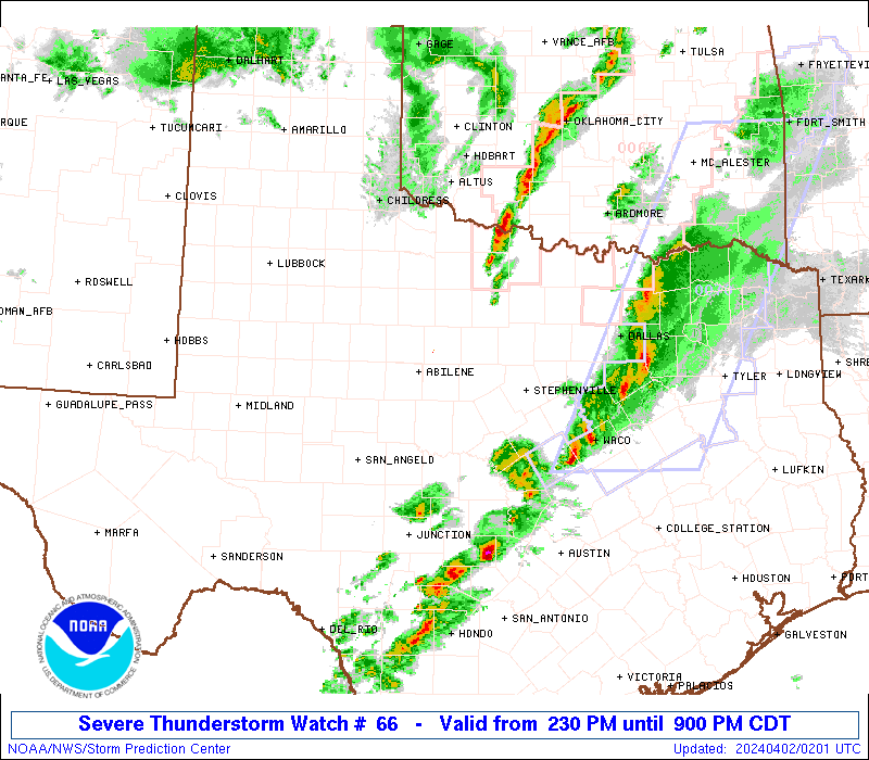
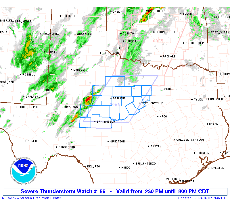
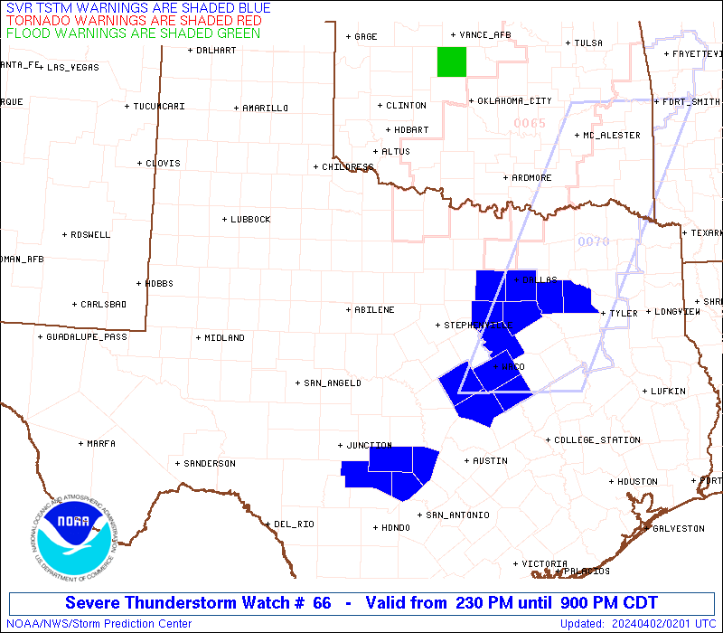
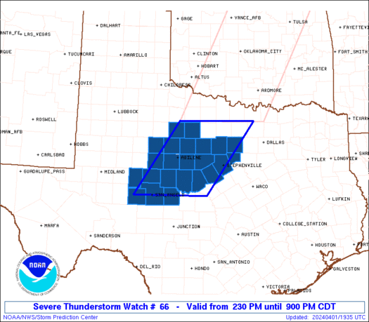
Tornado Watch Number 66
NWS Storm Prediction Center Norman OK
1225 PM CDT Fri Mar 28 2025
The NWS Storm Prediction Center has issued a
* Tornado Watch for portions of
Western Louisiana
Southeast and East Texas
Coastal Waters
* Effective this Friday afternoon and evening from 1225 PM until
700 PM CDT.
* Primary threats include...
A couple tornadoes possible
SUMMARY...Scattered thunderstorms will continue to intensify into
the afternoon as a moist and destabilizing airmass becomes more
favorable for supercell development with the stronger storms. A
couple of tornadoes are possible with the stronger storms through
the late afternoon and into the early evening before this activity
diminishes.
The tornado watch area is approximately along and 60 statute miles
east and west of a line from 55 miles west northwest of Natchitoches
LA to 10 miles east southeast of Port Arthur TX. For a complete
depiction of the watch see the associated watch outline update
(WOUS64 KWNS WOU6).
PRECAUTIONARY/PREPAREDNESS ACTIONS...
REMEMBER...A Tornado Watch means conditions are favorable for
tornadoes and severe thunderstorms in and close to the watch
area. Persons in these areas should be on the lookout for
threatening weather conditions and listen for later statements
and possible warnings.
&&
AVIATION...Tornadoes and a few severe thunderstorms with hail
surface and aloft to 1 inch. Extreme turbulence and surface wind
gusts to 60 knots. A few cumulonimbi with maximum tops to 450. Mean
storm motion vector 19025.
...Smith
 Note:
The Aviation Watch (SAW) product is an approximation to the watch area.
The actual watch is depicted by the shaded areas.
Note:
The Aviation Watch (SAW) product is an approximation to the watch area.
The actual watch is depicted by the shaded areas.
   SAW6
   WW 66 TORNADO LA TX CW 281725Z - 290000Z
   AXIS..60 STATUTE MILES EAST AND WEST OF LINE..
   55WNW IER/NATCHITOCHES LA/ - 10ESE BPT/PORT ARTHUR TX/
   ..AVIATION COORDS.. 50NM E/W /44S EIC - 42WSW LCH/
   HAIL SURFACE AND ALOFT..1 INCH. WIND GUSTS..60 KNOTS.
   MAX TOPS TO 450. MEAN STORM MOTION VECTOR 19025.

   LAT...LON 32049294 29899286 29899487 32049499

   THIS IS AN APPROXIMATION TO THE WATCH AREA.  FOR A
   COMPLETE DEPICTION OF THE WATCH SEE WOUS64 KWNS
   FOR WOU6.
Watch 66 Status Report Messages:
STATUS REPORT #6 ON WW 66

VALID 282330Z - 290040Z

THE SEVERE WEATHER THREAT CONTINUES ACROSS THE ENTIRE WATCH AREA.

..BROYLES..03/28/25

ATTN...WFO...LCH...SHV...HGX...

&&

STATUS REPORT FOR WT 66

SEVERE WEATHER THREAT CONTINUES FOR THE FOLLOWING AREAS

LAC011-019-023-031-069-081-085-115-290040-

LA
.    LOUISIANA PARISHES INCLUDED ARE

BEAUREGARD	     CALCASIEU		 CAMERON
DE SOTO 	     NATCHITOCHES	 RED RIVER
SABINE		     VERNON
$$


TXC005-199-241-245-291-347-351-361-373-403-405-419-457-290040-

TX
.    TEXAS COUNTIES INCLUDED ARE

ANGELINA	     HARDIN		 JASPER
JEFFERSON	     LIBERTY		 NACOGDOCHES
NEWTON		     ORANGE		 POLK
SABINE		     SAN AUGUSTINE	 SHELBY
TYLER
$$


GMZ430-432-290040-

CW

.    ADJACENT COASTAL WATERS INCLUDED ARE

SABINE LAKE

CALCASIEU LAKE

$$
THE WATCH STATUS MESSAGE IS FOR GUIDANCE PURPOSES ONLY.  PLEASE
REFER TO WATCH COUNTY NOTIFICATION STATEMENTS FOR OFFICIAL
INFORMATION ON COUNTIES...INDEPENDENT CITIES AND MARINE ZONES
CLEARED FROM SEVERE THUNDERSTORM AND TORNADO WATCHES.
$$

STATUS REPORT #5 ON WW 66

VALID 282250Z - 282340Z

THE SEVERE WEATHER THREAT CONTINUES ACROSS THE ENTIRE WATCH AREA.

..BROYLES..03/28/25

ATTN...WFO...LCH...SHV...HGX...

&&

STATUS REPORT FOR WT 66

SEVERE WEATHER THREAT CONTINUES FOR THE FOLLOWING AREAS

LAC011-019-023-031-069-081-085-115-282340-

LA
.    LOUISIANA PARISHES INCLUDED ARE

BEAUREGARD	     CALCASIEU		 CAMERON
DE SOTO 	     NATCHITOCHES	 RED RIVER
SABINE		     VERNON
$$


TXC005-199-241-245-291-347-351-361-373-403-405-419-457-282340-

TX
.    TEXAS COUNTIES INCLUDED ARE

ANGELINA	     HARDIN		 JASPER
JEFFERSON	     LIBERTY		 NACOGDOCHES
NEWTON		     ORANGE		 POLK
SABINE		     SAN AUGUSTINE	 SHELBY
TYLER
$$


GMZ430-432-282340-

CW

.    ADJACENT COASTAL WATERS INCLUDED ARE

SABINE LAKE

CALCASIEU LAKE

$$
THE WATCH STATUS MESSAGE IS FOR GUIDANCE PURPOSES ONLY.  PLEASE
REFER TO WATCH COUNTY NOTIFICATION STATEMENTS FOR OFFICIAL
INFORMATION ON COUNTIES...INDEPENDENT CITIES AND MARINE ZONES
CLEARED FROM SEVERE THUNDERSTORM AND TORNADO WATCHES.
$$

STATUS REPORT #4 ON WW 66

VALID 282140Z - 282240Z

THE SEVERE WEATHER THREAT CONTINUES ACROSS THE ENTIRE WATCH AREA.

..BROYLES..03/28/25

ATTN...WFO...LCH...SHV...HGX...

&&

STATUS REPORT FOR WT 66

SEVERE WEATHER THREAT CONTINUES FOR THE FOLLOWING AREAS

LAC011-019-023-031-069-081-085-115-282240-

LA
.    LOUISIANA PARISHES INCLUDED ARE

BEAUREGARD	     CALCASIEU		 CAMERON
DE SOTO 	     NATCHITOCHES	 RED RIVER
SABINE		     VERNON
$$


TXC005-199-241-245-291-347-351-361-373-403-405-419-457-282240-

TX
.    TEXAS COUNTIES INCLUDED ARE

ANGELINA	     HARDIN		 JASPER
JEFFERSON	     LIBERTY		 NACOGDOCHES
NEWTON		     ORANGE		 POLK
SABINE		     SAN AUGUSTINE	 SHELBY
TYLER
$$


GMZ430-432-282240-

CW

.    ADJACENT COASTAL WATERS INCLUDED ARE

SABINE LAKE

CALCASIEU LAKE

$$
THE WATCH STATUS MESSAGE IS FOR GUIDANCE PURPOSES ONLY.  PLEASE
REFER TO WATCH COUNTY NOTIFICATION STATEMENTS FOR OFFICIAL
INFORMATION ON COUNTIES...INDEPENDENT CITIES AND MARINE ZONES
CLEARED FROM SEVERE THUNDERSTORM AND TORNADO WATCHES.
$$

STATUS REPORT #3 ON WW 66

VALID 282005Z - 282140Z

THE SEVERE WEATHER THREAT CONTINUES ACROSS THE ENTIRE WATCH AREA.

..DEAN..03/28/25

ATTN...WFO...LCH...SHV...HGX...

&&

STATUS REPORT FOR WT 66

SEVERE WEATHER THREAT CONTINUES FOR THE FOLLOWING AREAS

LAC011-019-023-031-069-081-085-115-282140-

LA
.    LOUISIANA PARISHES INCLUDED ARE

BEAUREGARD	     CALCASIEU		 CAMERON
DE SOTO 	     NATCHITOCHES	 RED RIVER
SABINE		     VERNON
$$


TXC005-199-241-245-291-347-351-361-373-403-405-419-457-282140-

TX
.    TEXAS COUNTIES INCLUDED ARE

ANGELINA	     HARDIN		 JASPER
JEFFERSON	     LIBERTY		 NACOGDOCHES
NEWTON		     ORANGE		 POLK
SABINE		     SAN AUGUSTINE	 SHELBY
TYLER
$$


GMZ430-432-282140-

CW

.    ADJACENT COASTAL WATERS INCLUDED ARE

SABINE LAKE

CALCASIEU LAKE

$$
THE WATCH STATUS MESSAGE IS FOR GUIDANCE PURPOSES ONLY.  PLEASE
REFER TO WATCH COUNTY NOTIFICATION STATEMENTS FOR OFFICIAL
INFORMATION ON COUNTIES...INDEPENDENT CITIES AND MARINE ZONES
CLEARED FROM SEVERE THUNDERSTORM AND TORNADO WATCHES.
$$

STATUS REPORT #2 ON WW 66

VALID 281905Z - 282040Z

THE SEVERE WEATHER THREAT CONTINUES ACROSS THE ENTIRE WATCH AREA.

..DEAN..03/28/25

ATTN...WFO...LCH...SHV...HGX...

&&

STATUS REPORT FOR WT 66

SEVERE WEATHER THREAT CONTINUES FOR THE FOLLOWING AREAS

LAC011-019-023-031-069-081-085-115-282040-

LA
.    LOUISIANA PARISHES INCLUDED ARE

BEAUREGARD	     CALCASIEU		 CAMERON
DE SOTO 	     NATCHITOCHES	 RED RIVER
SABINE		     VERNON
$$


TXC005-199-241-245-291-347-351-361-373-403-405-419-457-282040-

TX
.    TEXAS COUNTIES INCLUDED ARE

ANGELINA	     HARDIN		 JASPER
JEFFERSON	     LIBERTY		 NACOGDOCHES
NEWTON		     ORANGE		 POLK
SABINE		     SAN AUGUSTINE	 SHELBY
TYLER
$$


GMZ430-432-282040-

CW

.    ADJACENT COASTAL WATERS INCLUDED ARE

SABINE LAKE

CALCASIEU LAKE

$$
THE WATCH STATUS MESSAGE IS FOR GUIDANCE PURPOSES ONLY.  PLEASE
REFER TO WATCH COUNTY NOTIFICATION STATEMENTS FOR OFFICIAL
INFORMATION ON COUNTIES...INDEPENDENT CITIES AND MARINE ZONES
CLEARED FROM SEVERE THUNDERSTORM AND TORNADO WATCHES.
$$

STATUS REPORT #1 ON WW 66

VALID 281815Z - 281940Z

THE SEVERE WEATHER THREAT CONTINUES ACROSS THE ENTIRE WATCH AREA.

..DEAN..03/28/25

ATTN...WFO...LCH...SHV...HGX...

&&

STATUS REPORT FOR WT 66

SEVERE WEATHER THREAT CONTINUES FOR THE FOLLOWING AREAS

LAC011-019-023-031-069-081-085-115-281940-

LA
.    LOUISIANA PARISHES INCLUDED ARE

BEAUREGARD	     CALCASIEU		 CAMERON
DE SOTO 	     NATCHITOCHES	 RED RIVER
SABINE		     VERNON
$$


TXC005-199-241-245-291-347-351-361-373-403-405-419-457-281940-

TX
.    TEXAS COUNTIES INCLUDED ARE

ANGELINA	     HARDIN		 JASPER
JEFFERSON	     LIBERTY		 NACOGDOCHES
NEWTON		     ORANGE		 POLK
SABINE		     SAN AUGUSTINE	 SHELBY
TYLER
$$


GMZ430-432-281940-

CW

.    ADJACENT COASTAL WATERS INCLUDED ARE

SABINE LAKE

CALCASIEU LAKE

$$
THE WATCH STATUS MESSAGE IS FOR GUIDANCE PURPOSES ONLY.  PLEASE
REFER TO WATCH COUNTY NOTIFICATION STATEMENTS FOR OFFICIAL
INFORMATION ON COUNTIES...INDEPENDENT CITIES AND MARINE ZONES
CLEARED FROM SEVERE THUNDERSTORM AND TORNADO WATCHES.
$$
Note:
Click for Complete Product Text.
Tornadoes
Probability of 2 or more tornadoes
|
Mod (40%)
|
Probability of 1 or more strong (EF2-EF5) tornadoes
|
Low (10%)
|
Wind
Probability of 10 or more severe wind events
|
Low (10%)
|
Probability of 1 or more wind events > 65 knots
|
Low (10%)
|
Hail
Probability of 10 or more severe hail events
|
Low (<5%)
|
Probability of 1 or more hailstones > 2 inches
|
Low (<5%)
|
Combined Severe Hail/Wind
Probability of 6 or more combined severe hail/wind events
|
Mod (30%)
|
For each watch, probabilities for particular events inside the watch
(listed above in each table) are determined by the issuing forecaster.
The "Low" category contains probability values ranging from less than 2%
to 20% (EF2-EF5 tornadoes), less than 5% to 20% (all other probabilities),
"Moderate" from 30% to 60%, and "High" from 70% to greater than 95%.
High values are bolded and lighter in color to provide awareness of
an increased threat for a particular event.


 @NWSSPC