Note:
The expiration time in the watch graphic is amended if the watch is
replaced, cancelled or extended.
Note:
Note:
The expiration time in the watch graphic is amended if the watch is
replaced, cancelled or extended.
Note: Click for
Watch Status Reports.
SEL3
URGENT - IMMEDIATE BROADCAST REQUESTED
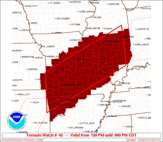
Tornado Watch Number 43
NWS Storm Prediction Center Norman OK
130 PM CDT Thu Mar 14 2024
The NWS Storm Prediction Center has issued a
* Tornado Watch for portions of
northwestern Arkansas
central and southern Illinois
far southeastern Kansas
southern/central/eastern Missouri
* Effective this Thursday afternoon and evening from 130 PM until
900 PM CDT.
* Primary threats include...
A few tornadoes likely
Widespread large hail and isolated very large hail events to 3
inches in diameter likely
Scattered damaging wind gusts to 70 mph possible
SUMMARY...Strong/severe thunderstorms will develop across/spread
into Missouri and northwestern Arkansas over the next one to two
hours, expanding eastward across Illinois with time. Along with
potential for tornadoes, very large hail is expected. Locally
damaging winds will also be possible, particularly as storms become
more clustered later this afternoon and this evening.
The tornado watch area is approximately along and 90 statute miles
north and south of a line from 25 miles south southwest of Joplin MO
to 10 miles east of Mattoon IL. For a complete depiction of the
watch see the associated watch outline update (WOUS64 KWNS WOU3).
PRECAUTIONARY/PREPAREDNESS ACTIONS...
REMEMBER...A Tornado Watch means conditions are favorable for
tornadoes and severe thunderstorms in and close to the watch
area. Persons in these areas should be on the lookout for
threatening weather conditions and listen for later statements
and possible warnings.
&&
OTHER WATCH INFORMATION...CONTINUE...WW 41...WW 42...
AVIATION...Tornadoes and a few severe thunderstorms with hail
surface and aloft to 3 inches. Extreme turbulence and surface wind
gusts to 60 knots. A few cumulonimbi with maximum tops to 500. Mean
storm motion vector 25040.
...Goss

   SEL3

   URGENT - IMMEDIATE BROADCAST REQUESTED
   Tornado Watch Number 43
   NWS Storm Prediction Center Norman OK
   130 PM CDT Thu Mar 14 2024

   The NWS Storm Prediction Center has issued a

   * Tornado Watch for portions of
     northwestern Arkansas
     central and southern Illinois
     far southeastern Kansas
     southern/central/eastern Missouri

   * Effective this Thursday afternoon and evening from 130 PM until
     900 PM CDT.

   * Primary threats include...
     A few tornadoes likely
     Widespread large hail and isolated very large hail events to 3
       inches in diameter likely
     Scattered damaging wind gusts to 70 mph possible

   SUMMARY...Strong/severe thunderstorms will develop across/spread
   into Missouri and northwestern Arkansas over the next one to two
   hours, expanding eastward across Illinois with time.  Along with
   potential for tornadoes, very large hail is expected.  Locally
   damaging winds will also be possible, particularly as storms become
   more clustered later this afternoon and this evening.

   The tornado watch area is approximately along and 90 statute miles
   north and south of a line from 25 miles south southwest of Joplin MO
   to 10 miles east of Mattoon IL. For a complete depiction of the
   watch see the associated watch outline update (WOUS64 KWNS WOU3).

   PRECAUTIONARY/PREPAREDNESS ACTIONS...

   REMEMBER...A Tornado Watch means conditions are favorable for
   tornadoes and severe thunderstorms in and close to the watch
   area. Persons in these areas should be on the lookout for
   threatening weather conditions and listen for later statements
   and possible warnings.

   &&

   OTHER WATCH INFORMATION...CONTINUE...WW 41...WW 42...

   AVIATION...Tornadoes and a few severe thunderstorms with hail
   surface and aloft to 3 inches. Extreme turbulence and surface wind
   gusts to 60 knots. A few cumulonimbi with maximum tops to 500. Mean
   storm motion vector 25040.

   ...Goss
 Note:
The Aviation Watch (SAW) product is an approximation to the watch area.
The actual watch is depicted by the shaded areas.
Note:
The Aviation Watch (SAW) product is an approximation to the watch area.
The actual watch is depicted by the shaded areas.
   SAW3
   WW 43 TORNADO AR IL KS MO 141830Z - 150200Z
   AXIS..90 STATUTE MILES NORTH AND SOUTH OF LINE..
   25SSW JLN/JOPLIN MO/ - 10E MTO/MATTOON IL/
   ..AVIATION COORDS.. 80NM N/S /32SE OSW - 39ESE AXC/
   HAIL SURFACE AND ALOFT..3 INCHES. WIND GUSTS..60 KNOTS.
   MAX TOPS TO 500. MEAN STORM MOTION VECTOR 25040.

   LAT...LON 38129467 40778809 38168809 35509467

   THIS IS AN APPROXIMATION TO THE WATCH AREA.  FOR A
   COMPLETE DEPICTION OF THE WATCH SEE WOUS64 KWNS
   FOR WOU3.
Watch 43 Status Report Messages:
STATUS REPORT #7 ON WW 43

VALID 150135Z - 150240Z

SEVERE WEATHER THREAT CONTINUES RIGHT OF A LINE FROM 15 SE MDH TO
20 NE SLO TO 15 SSE HUF.

..SQUITIERI..03/15/24

ATTN...WFO...LZK...TSA...LSX...ILX...PAH...SGF...EAX...

&&

STATUS REPORT FOR WT 43

SEVERE WEATHER THREAT CONTINUES FOR THE FOLLOWING AREAS

ARC071-150240-

AR
.    ARKANSAS COUNTIES INCLUDED ARE

JOHNSON
$$


ILC025-033-047-101-159-185-191-150240-

IL
.    ILLINOIS COUNTIES INCLUDED ARE

CLAY		     CRAWFORD		 EDWARDS
LAWRENCE	     RICHLAND		 WABASH
WAYNE
$$


THE WATCH STATUS MESSAGE IS FOR GUIDANCE PURPOSES ONLY.  PLEASE
REFER TO WATCH COUNTY NOTIFICATION STATEMENTS FOR OFFICIAL
INFORMATION ON COUNTIES...INDEPENDENT CITIES AND MARINE ZONES
CLEARED FROM SEVERE THUNDERSTORM AND TORNADO WATCHES.
$$

STATUS REPORT #6 ON WW 43

VALID 150055Z - 150140Z

SEVERE WEATHER THREAT CONTINUES RIGHT OF A LINE FROM 20 NW CGI TO
5 WNW BLV TO 25 SE MTO.

FOR ADDITIONAL INFORMATION SEE MESOSCALE DISCUSSION 245

..SQUITIERI..03/15/24

ATTN...WFO...LZK...TSA...LSX...ILX...PAH...SGF...EAX...

&&

STATUS REPORT FOR WT 43

SEVERE WEATHER THREAT CONTINUES FOR THE FOLLOWING AREAS

ARC071-150140-

AR
.    ARKANSAS COUNTIES INCLUDED ARE

JOHNSON
$$


ILC025-027-033-047-055-077-081-101-121-145-157-159-185-189-191-
150140-

IL
.    ILLINOIS COUNTIES INCLUDED ARE

CLAY		     CLINTON		 CRAWFORD
EDWARDS 	     FRANKLIN		 JACKSON
JEFFERSON	     LAWRENCE		 MARION
PERRY		     RANDOLPH		 RICHLAND
WABASH		     WASHINGTON 	 WAYNE
$$


MOC017-031-157-150140-

MO
.    MISSOURI COUNTIES INCLUDED ARE

BOLLINGER	     CAPE GIRARDEAU	 PERRY
$$


THE WATCH STATUS MESSAGE IS FOR GUIDANCE PURPOSES ONLY.  PLEASE
REFER TO WATCH COUNTY NOTIFICATION STATEMENTS FOR OFFICIAL
INFORMATION ON COUNTIES...INDEPENDENT CITIES AND MARINE ZONES
CLEARED FROM SEVERE THUNDERSTORM AND TORNADO WATCHES.
$$

STATUS REPORT #5 ON WW 43

VALID 150010Z - 150140Z

SEVERE WEATHER THREAT CONTINUES RIGHT OF A LINE FROM 20 NW POF TO
10 N FAM TO 20 SW STL TO 35 WNW STL TO 45 WNW STL TO 20 ESE CMI.

..SQUITIERI..03/15/24

ATTN...WFO...LZK...TSA...LSX...ILX...PAH...SGF...EAX...

&&

STATUS REPORT FOR WT 43

SEVERE WEATHER THREAT CONTINUES FOR THE FOLLOWING AREAS

ARC071-129-150140-

AR
.    ARKANSAS COUNTIES INCLUDED ARE

JOHNSON 	     SEARCY
$$


ILC005-013-019-021-023-025-027-029-033-035-041-045-047-049-051-
055-077-079-081-083-101-115-117-119-121-133-135-139-145-147-157-
159-163-173-183-185-189-191-150140-

IL
.    ILLINOIS COUNTIES INCLUDED ARE

BOND		     CALHOUN		 CHAMPAIGN
CHRISTIAN	     CLARK		 CLAY
CLINTON 	     COLES		 CRAWFORD
CUMBERLAND	     DOUGLAS		 EDGAR
EDWARDS 	     EFFINGHAM		 FAYETTE
FRANKLIN	     JACKSON		 JASPER
JEFFERSON	     JERSEY		 LAWRENCE
MACON		     MACOUPIN		 MADISON
MARION		     MONROE		 MONTGOMERY
MOULTRIE	     PERRY		 PIATT
RANDOLPH	     RICHLAND		 ST. CLAIR
SHELBY		     VERMILION		 WABASH
WASHINGTON	     WAYNE
$$


MOC017-031-099-113-123-157-183-186-187-189-223-510-150140-

MO
.    MISSOURI COUNTIES INCLUDED ARE

BOLLINGER	     CAPE GIRARDEAU	 JEFFERSON
LINCOLN 	     MADISON		 PERRY
ST. CHARLES	     STE. GENEVIEVE	 ST. FRANCOIS
ST. LOUIS	     WAYNE


MISSOURI INDEPENDENT CITIES INCLUDED ARE

ST. LOUIS CITY
$$


THE WATCH STATUS MESSAGE IS FOR GUIDANCE PURPOSES ONLY.  PLEASE
REFER TO WATCH COUNTY NOTIFICATION STATEMENTS FOR OFFICIAL
INFORMATION ON COUNTIES...INDEPENDENT CITIES AND MARINE ZONES
CLEARED FROM SEVERE THUNDERSTORM AND TORNADO WATCHES.
$$

STATUS REPORT #4 ON WW 43

VALID 142320Z - 150040Z

SEVERE WEATHER THREAT CONTINUES RIGHT OF A LINE FROM 20 ESE UNO
TO 45 SW FAM TO 25 ESE VIH TO 30 W JEF TO 30 NNW STL TO 20 ESE
CMI.

..SQUITIERI..03/14/24

ATTN...WFO...LZK...TSA...LSX...ILX...PAH...SGF...EAX...

&&

STATUS REPORT FOR WT 43

SEVERE WEATHER THREAT CONTINUES FOR THE FOLLOWING AREAS

ARC049-071-087-101-129-150040-

AR
.    ARKANSAS COUNTIES INCLUDED ARE

FULTON		     JOHNSON		 MADISON
NEWTON		     SEARCY
$$


ILC005-013-019-021-023-025-027-029-033-035-041-045-047-049-051-
055-077-079-081-083-101-115-117-119-121-133-135-139-145-147-157-
159-163-173-183-185-189-191-150040-

IL
.    ILLINOIS COUNTIES INCLUDED ARE

BOND		     CALHOUN		 CHAMPAIGN
CHRISTIAN	     CLARK		 CLAY
CLINTON 	     COLES		 CRAWFORD
CUMBERLAND	     DOUGLAS		 EDGAR
EDWARDS 	     EFFINGHAM		 FAYETTE
FRANKLIN	     JACKSON		 JASPER
JEFFERSON	     JERSEY		 LAWRENCE
MACON		     MACOUPIN		 MADISON
MARION		     MONROE		 MONTGOMERY
MOULTRIE	     PERRY		 PIATT
RANDOLPH	     RICHLAND		 ST. CLAIR
SHELBY		     VERMILION		 WABASH
WASHINGTON	     WAYNE
$$


MOC017-027-031-035-051-055-071-073-093-099-113-123-139-149-151-
157-179-183-186-187-189-219-221-223-510-150040-

MO
.    MISSOURI COUNTIES INCLUDED ARE

BOLLINGER	     CALLAWAY		 CAPE GIRARDEAU
CARTER		     COLE		 CRAWFORD
FRANKLIN	     GASCONADE		 IRON
JEFFERSON	     LINCOLN		 MADISON
MONTGOMERY	     OREGON		 OSAGE
PERRY		     REYNOLDS		 ST. CHARLES
STE. GENEVIEVE	     ST. FRANCOIS	 ST. LOUIS
WARREN		     WASHINGTON 	 WAYNE


MISSOURI INDEPENDENT CITIES INCLUDED ARE

ST. LOUIS CITY
$$


THE WATCH STATUS MESSAGE IS FOR GUIDANCE PURPOSES ONLY.  PLEASE
REFER TO WATCH COUNTY NOTIFICATION STATEMENTS FOR OFFICIAL
INFORMATION ON COUNTIES...INDEPENDENT CITIES AND MARINE ZONES
CLEARED FROM SEVERE THUNDERSTORM AND TORNADO WATCHES.
$$

STATUS REPORT #3 ON WW 43

VALID 142240Z - 142340Z

SEVERE WEATHER THREAT CONTINUES RIGHT OF A LINE FROM 35 WSW FYV
TO 15 NNW FLP TO 25 NNW UNO TO 15 SE TBN TO 25 ESE SZL TO 20 WNW
DNV.

..SQUITIERI..03/14/24

ATTN...WFO...LZK...TSA...LSX...ILX...PAH...SGF...EAX...

&&

STATUS REPORT FOR WT 43

SEVERE WEATHER THREAT CONTINUES FOR THE FOLLOWING AREAS

ARC005-049-071-087-089-101-129-143-142340-

AR
.    ARKANSAS COUNTIES INCLUDED ARE

BAXTER		     FULTON		 JOHNSON
MADISON 	     MARION		 NEWTON
SEARCY		     WASHINGTON
$$


ILC005-013-019-021-023-025-027-029-033-035-041-045-047-049-051-
055-061-077-079-081-083-101-115-117-119-121-133-135-139-145-147-
157-159-163-173-183-185-189-191-142340-

IL
.    ILLINOIS COUNTIES INCLUDED ARE

BOND		     CALHOUN		 CHAMPAIGN
CHRISTIAN	     CLARK		 CLAY
CLINTON 	     COLES		 CRAWFORD
CUMBERLAND	     DOUGLAS		 EDGAR
EDWARDS 	     EFFINGHAM		 FAYETTE
FRANKLIN	     GREENE		 JACKSON
JASPER		     JEFFERSON		 JERSEY
LAWRENCE	     MACON		 MACOUPIN
MADISON 	     MARION		 MONROE
MONTGOMERY	     MOULTRIE		 PERRY
PIATT		     RANDOLPH		 RICHLAND
ST. CLAIR	     SHELBY		 VERMILION
WABASH		     WASHINGTON 	 WAYNE
$$


MOC017-027-031-035-051-055-065-071-073-091-093-099-113-123-125-
131-135-139-141-149-151-157-161-179-183-186-187-189-203-219-221-
223-510-142340-

MO
.    MISSOURI COUNTIES INCLUDED ARE

BOLLINGER	     CALLAWAY		 CAPE GIRARDEAU
CARTER		     COLE		 CRAWFORD
DENT		     FRANKLIN		 GASCONADE
HOWELL		     IRON		 JEFFERSON
LINCOLN 	     MADISON		 MARIES
MILLER		     MONITEAU		 MONTGOMERY
MORGAN		     OREGON		 OSAGE
PERRY		     PHELPS		 REYNOLDS
ST. CHARLES	     STE. GENEVIEVE	 ST. FRANCOIS
ST. LOUIS	     SHANNON		 WARREN
WASHINGTON	     WAYNE


MISSOURI INDEPENDENT CITIES INCLUDED ARE

ST. LOUIS CITY
$$


THE WATCH STATUS MESSAGE IS FOR GUIDANCE PURPOSES ONLY.  PLEASE
REFER TO WATCH COUNTY NOTIFICATION STATEMENTS FOR OFFICIAL
INFORMATION ON COUNTIES...INDEPENDENT CITIES AND MARINE ZONES
CLEARED FROM SEVERE THUNDERSTORM AND TORNADO WATCHES.
$$

STATUS REPORT #2 ON WW 43

VALID 142155Z - 142240Z

THE SEVERE WEATHER THREAT CONTINUES ACROSS THE ENTIRE WATCH AREA.

..SQUITIERI..03/14/24

ATTN...WFO...LZK...TSA...LSX...ILX...PAH...SGF...EAX...

&&

STATUS REPORT FOR WT 43

SEVERE WEATHER THREAT CONTINUES FOR THE FOLLOWING AREAS

ARC005-007-009-015-033-047-049-071-087-089-101-129-131-143-
142240-

AR
.    ARKANSAS COUNTIES INCLUDED ARE

BAXTER		     BENTON		 BOONE
CARROLL 	     CRAWFORD		 FRANKLIN
FULTON		     JOHNSON		 MADISON
MARION		     NEWTON		 SEARCY
SEBASTIAN	     WASHINGTON
$$


ILC005-013-019-021-023-025-027-029-033-035-039-041-045-047-049-
051-055-061-077-079-081-083-101-115-117-119-121-133-135-137-139-
145-147-157-159-163-167-171-173-183-185-189-191-142240-

IL
.    ILLINOIS COUNTIES INCLUDED ARE

BOND		     CALHOUN		 CHAMPAIGN
CHRISTIAN	     CLARK		 CLAY
CLINTON 	     COLES		 CRAWFORD
CUMBERLAND	     DE WITT		 DOUGLAS
EDGAR		     EDWARDS		 EFFINGHAM
FAYETTE 	     FRANKLIN		 GREENE
JACKSON 	     JASPER		 JEFFERSON
JERSEY		     LAWRENCE		 MACON
MACOUPIN	     MADISON		 MARION
MONROE		     MONTGOMERY 	 MORGAN
MOULTRIE	     PERRY		 PIATT
RANDOLPH	     RICHLAND		 ST. CLAIR
SANGAMON	     SCOTT		 SHELBY
VERMILION	     WABASH		 WASHINGTON
WAYNE
$$


KSC021-142240-

KS
.    KANSAS COUNTIES INCLUDED ARE

CHEROKEE
$$


MOC009-011-015-017-019-027-029-031-035-039-043-051-055-057-059-
065-067-071-073-077-085-091-093-097-099-105-109-113-119-123-125-
131-135-139-141-145-149-151-153-157-161-163-167-169-179-183-185-
186-187-189-203-209-213-215-217-219-221-223-225-229-510-
142240-

MO
.    MISSOURI COUNTIES INCLUDED ARE

BARRY		     BARTON		 BENTON
BOLLINGER	     BOONE		 CALLAWAY
CAMDEN		     CAPE GIRARDEAU	 CARTER
CEDAR		     CHRISTIAN		 COLE
CRAWFORD	     DADE		 DALLAS
DENT		     DOUGLAS		 FRANKLIN
GASCONADE	     GREENE		 HICKORY
HOWELL		     IRON		 JASPER
JEFFERSON	     LACLEDE		 LAWRENCE
LINCOLN 	     MCDONALD		 MADISON
MARIES		     MILLER		 MONITEAU
MONTGOMERY	     MORGAN		 NEWTON
OREGON		     OSAGE		 OZARK
PERRY		     PHELPS		 PIKE
POLK		     PULASKI		 REYNOLDS
ST. CHARLES	     ST. CLAIR		 STE. GENEVIEVE
ST. FRANCOIS	     ST. LOUIS		 SHANNON
STONE		     TANEY		 TEXAS
VERNON		     WARREN		 WASHINGTON
WAYNE		     WEBSTER		 WRIGHT


MISSOURI INDEPENDENT CITIES INCLUDED ARE

ST. LOUIS CITY
$$


THE WATCH STATUS MESSAGE IS FOR GUIDANCE PURPOSES ONLY.  PLEASE
REFER TO WATCH COUNTY NOTIFICATION STATEMENTS FOR OFFICIAL
INFORMATION ON COUNTIES...INDEPENDENT CITIES AND MARINE ZONES
CLEARED FROM SEVERE THUNDERSTORM AND TORNADO WATCHES.
$$

STATUS REPORT #1 ON WW 43

VALID 142100Z - 142240Z

THE SEVERE WEATHER THREAT CONTINUES ACROSS THE ENTIRE WATCH AREA.

FOR ADDITIONAL INFORMATION SEE MESOSCALE DISCUSSION 237

..SQUITIERI..03/14/24

ATTN...WFO...LZK...TSA...LSX...ILX...PAH...SGF...EAX...

&&

STATUS REPORT FOR WT 43

SEVERE WEATHER THREAT CONTINUES FOR THE FOLLOWING AREAS

ARC005-007-009-015-033-047-049-071-087-089-101-129-131-143-
142240-

AR
.    ARKANSAS COUNTIES INCLUDED ARE

BAXTER		     BENTON		 BOONE
CARROLL 	     CRAWFORD		 FRANKLIN
FULTON		     JOHNSON		 MADISON
MARION		     NEWTON		 SEARCY
SEBASTIAN	     WASHINGTON
$$


ILC005-009-013-017-019-021-023-025-027-029-033-035-039-041-045-
047-049-051-055-061-077-079-081-083-101-107-115-117-119-121-125-
129-133-135-137-139-145-147-149-157-159-163-167-171-173-183-185-
189-191-142240-

IL
.    ILLINOIS COUNTIES INCLUDED ARE

BOND		     BROWN		 CALHOUN
CASS		     CHAMPAIGN		 CHRISTIAN
CLARK		     CLAY		 CLINTON
COLES		     CRAWFORD		 CUMBERLAND
DE WITT 	     DOUGLAS		 EDGAR
EDWARDS 	     EFFINGHAM		 FAYETTE
FRANKLIN	     GREENE		 JACKSON
JASPER		     JEFFERSON		 JERSEY
LAWRENCE	     LOGAN		 MACON
MACOUPIN	     MADISON		 MARION
MASON		     MENARD		 MONROE
MONTGOMERY	     MORGAN		 MOULTRIE
PERRY		     PIATT		 PIKE
RANDOLPH	     RICHLAND		 ST. CLAIR
SANGAMON	     SCOTT		 SHELBY
VERMILION	     WABASH		 WASHINGTON
WAYNE
$$


KSC021-037-142240-

KS
.    KANSAS COUNTIES INCLUDED ARE

CHEROKEE	     CRAWFORD
$$


MOC007-009-011-015-017-019-027-029-031-035-039-043-051-053-055-
057-059-065-067-071-073-077-085-091-093-097-099-105-109-113-119-
123-125-131-135-139-141-145-149-151-153-157-161-163-167-169-173-
179-183-185-186-187-189-203-209-213-215-217-219-221-223-225-229-
510-142240-

MO
.    MISSOURI COUNTIES INCLUDED ARE

AUDRAIN 	     BARRY		 BARTON
BENTON		     BOLLINGER		 BOONE
CALLAWAY	     CAMDEN		 CAPE GIRARDEAU
CARTER		     CEDAR		 CHRISTIAN
COLE		     COOPER		 CRAWFORD
DADE		     DALLAS		 DENT
DOUGLAS 	     FRANKLIN		 GASCONADE
GREENE		     HICKORY		 HOWELL
IRON		     JASPER		 JEFFERSON
LACLEDE 	     LAWRENCE		 LINCOLN
MCDONALD	     MADISON		 MARIES
MILLER		     MONITEAU		 MONTGOMERY
MORGAN		     NEWTON		 OREGON
OSAGE		     OZARK		 PERRY
PHELPS		     PIKE		 POLK
PULASKI 	     RALLS		 REYNOLDS
ST. CHARLES	     ST. CLAIR		 STE. GENEVIEVE
ST. FRANCOIS	     ST. LOUIS		 SHANNON
STONE		     TANEY		 TEXAS
VERNON		     WARREN		 WASHINGTON
WAYNE		     WEBSTER		 WRIGHT


MISSOURI INDEPENDENT CITIES INCLUDED ARE

ST. LOUIS CITY
$$


THE WATCH STATUS MESSAGE IS FOR GUIDANCE PURPOSES ONLY.  PLEASE
REFER TO WATCH COUNTY NOTIFICATION STATEMENTS FOR OFFICIAL
INFORMATION ON COUNTIES...INDEPENDENT CITIES AND MARINE ZONES
CLEARED FROM SEVERE THUNDERSTORM AND TORNADO WATCHES.
$$
Note:
Click for Complete Product Text.
Tornadoes
Probability of 2 or more tornadoes
|
Mod (60%)
|
Probability of 1 or more strong (EF2-EF5) tornadoes
|
Low (20%)
|
Wind
Probability of 10 or more severe wind events
|
Mod (50%)
|
Probability of 1 or more wind events > 65 knots
|
Low (20%)
|
Hail
Probability of 10 or more severe hail events
|
High (80%)
|
Probability of 1 or more hailstones > 2 inches
|
Mod (60%)
|
Combined Severe Hail/Wind
Probability of 6 or more combined severe hail/wind events
|
High (>95%)
|
For each watch, probabilities for particular events inside the watch
(listed above in each table) are determined by the issuing forecaster.
The "Low" category contains probability values ranging from less than 2%
to 20% (EF2-EF5 tornadoes), less than 5% to 20% (all other probabilities),
"Moderate" from 30% to 60%, and "High" from 70% to greater than 95%.
High values are bolded and lighter in color to provide awareness of
an increased threat for a particular event.


 @NWSSPC