Note:
The expiration time in the watch graphic is amended if the watch is
replaced, cancelled or extended.
Note:
Note:
The expiration time in the watch graphic is amended if the watch is
replaced, cancelled or extended.
Note: Click for
Watch Status Reports.
SEL9
URGENT - IMMEDIATE BROADCAST REQUESTED
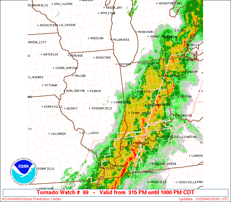
Tornado Watch Number 99
NWS Storm Prediction Center Norman OK
315 PM CDT Wed Apr 2 2025
The NWS Storm Prediction Center has issued a
* Tornado Watch for portions of
Central and Eastern Illinois
Western and Central Indiana
* Effective this Wednesday afternoon and evening from 315 PM
until 1000 PM CDT.
* Primary threats include...
Several tornadoes likely with a couple intense tornadoes
possible
Widespread damaging winds likely with isolated significant gusts
to 80 mph possible
Scattered large hail events to 1.5 inches in diameter possible
SUMMARY...Severe storms are expected to develop and increase
initially across central/northeast Illinois late this afternoon, and
steadily progress east-northeastward into eastern Illinois and much
of western/central/northern Indiana by evening.
The tornado watch area is approximately along and 90 statute miles
north and south of a line from 30 miles west northwest of Decatur IL
to 45 miles north northeast of Indianapolis IN. For a complete
depiction of the watch see the associated watch outline update
(WOUS64 KWNS WOU9).
PRECAUTIONARY/PREPAREDNESS ACTIONS...
REMEMBER...A Tornado Watch means conditions are favorable for
tornadoes and severe thunderstorms in and close to the watch
area. Persons in these areas should be on the lookout for
threatening weather conditions and listen for later statements
and possible warnings.
&&
OTHER WATCH INFORMATION...CONTINUE...WW 97...WW 98...
AVIATION...Tornadoes and a few severe thunderstorms with hail
surface and aloft to 1.5 inches. Extreme turbulence and surface wind
gusts to 70 knots. A few cumulonimbi with maximum tops to 500. Mean
storm motion vector 23035.
...Guyer

   SEL9

   URGENT - IMMEDIATE BROADCAST REQUESTED
   Tornado Watch Number 99
   NWS Storm Prediction Center Norman OK
   315 PM CDT Wed Apr 2 2025

   The NWS Storm Prediction Center has issued a

   * Tornado Watch for portions of
     Central and Eastern Illinois
     Western and Central Indiana

   * Effective this Wednesday afternoon and evening from 315 PM
     until 1000 PM CDT.

   * Primary threats include...
     Several tornadoes likely with a couple intense tornadoes
       possible
     Widespread damaging winds likely with isolated significant gusts
       to 80 mph possible
     Scattered large hail events to 1.5 inches in diameter possible

   SUMMARY...Severe storms are expected to develop and increase
   initially across central/northeast Illinois late this afternoon, and
   steadily progress east-northeastward into eastern Illinois and much
   of western/central/northern Indiana by evening.

   The tornado watch area is approximately along and 90 statute miles
   north and south of a line from 30 miles west northwest of Decatur IL
   to 45 miles north northeast of Indianapolis IN. For a complete
   depiction of the watch see the associated watch outline update
   (WOUS64 KWNS WOU9).

   PRECAUTIONARY/PREPAREDNESS ACTIONS...

   REMEMBER...A Tornado Watch means conditions are favorable for
   tornadoes and severe thunderstorms in and close to the watch
   area. Persons in these areas should be on the lookout for
   threatening weather conditions and listen for later statements
   and possible warnings.

   &&

   OTHER WATCH INFORMATION...CONTINUE...WW 97...WW 98...

   AVIATION...Tornadoes and a few severe thunderstorms with hail
   surface and aloft to 1.5 inches. Extreme turbulence and surface wind
   gusts to 70 knots. A few cumulonimbi with maximum tops to 500. Mean
   storm motion vector 23035.

   ...Guyer
 Note:
The Aviation Watch (SAW) product is an approximation to the watch area.
The actual watch is depicted by the shaded areas.
Note:
The Aviation Watch (SAW) product is an approximation to the watch area.
The actual watch is depicted by the shaded areas.
   SAW9
   WW 99 TORNADO IL IN 022015Z - 030300Z
   AXIS..90 STATUTE MILES NORTH AND SOUTH OF LINE..
   30WNW DEC/DECATUR IL/ - 45NNE IND/INDIANAPOLIS IN/
   ..AVIATION COORDS.. 80NM N/S /29WNW AXC - 36NNE IND/
   HAIL SURFACE AND ALOFT..1.5 INCHES. WIND GUSTS..70 KNOTS.
   MAX TOPS TO 500. MEAN STORM MOTION VECTOR 23035.

   LAT...LON 41308939 41628595 39028595 38688939

   THIS IS AN APPROXIMATION TO THE WATCH AREA.  FOR A
   COMPLETE DEPICTION OF THE WATCH SEE WOUS64 KWNS
   FOR WOU9.
Watch 99 Status Report Messages:
STATUS REPORT #3 ON WW 99

VALID 030130Z - 030240Z

SEVERE WEATHER THREAT CONTINUES RIGHT OF A LINE FROM 45 NNW EVV
TO 20 NW IND TO 15 ENE SBN.

FOR ADDITIONAL INFORMATION SEE MESOSCALE DISCUSSION 367

..WEINMAN..04/03/25

ATTN...WFO...ILX...LOT...IND...IWX...

&&

STATUS REPORT FOR WT 99

SEVERE WEATHER THREAT CONTINUES FOR THE FOLLOWING AREAS

ILC101-030240-

IL
.    ILLINOIS COUNTIES INCLUDED ARE

LAWRENCE
$$


INC001-003-009-011-013-017-021-023-027-033-039-049-053-055-057-
063-067-069-075-081-083-085-087-093-097-099-101-103-105-109-113-
119-133-151-153-159-169-179-183-030240-

IN
.    INDIANA COUNTIES INCLUDED ARE

ADAMS		     ALLEN		 BLACKFORD
BOONE		     BROWN		 CASS
CLAY		     CLINTON		 DAVIESS
DE KALB 	     ELKHART		 FULTON
GRANT		     GREENE		 HAMILTON
HENDRICKS	     HOWARD		 HUNTINGTON
JAY		     JOHNSON		 KNOX
KOSCIUSKO	     LAGRANGE		 LAWRENCE
MARION		     MARSHALL		 MARTIN
MIAMI		     MONROE		 MORGAN
NOBLE		     OWEN		 PUTNAM
STEUBEN 	     SULLIVAN		 TIPTON
WABASH		     WELLS		 WHITLEY
$$


THE WATCH STATUS MESSAGE IS FOR GUIDANCE PURPOSES ONLY.  PLEASE
REFER TO WATCH COUNTY NOTIFICATION STATEMENTS FOR OFFICIAL
INFORMATION ON COUNTIES...INDEPENDENT CITIES AND MARINE ZONES
CLEARED FROM SEVERE THUNDERSTORM AND TORNADO WATCHES.
$$

STATUS REPORT #2 ON WW 99

VALID 030050Z - 030140Z

SEVERE WEATHER THREAT CONTINUES RIGHT OF A LINE FROM 10 E SLO TO
10 NNW HUF TO 15 WNW SBN.

..WEINMAN..04/03/25

ATTN...WFO...ILX...LOT...IND...IWX...

&&

STATUS REPORT FOR WT 99

SEVERE WEATHER THREAT CONTINUES FOR THE FOLLOWING AREAS

ILC023-025-033-079-101-159-030140-

IL
.    ILLINOIS COUNTIES INCLUDED ARE

CLARK		     CLAY		 CRAWFORD
JASPER		     LAWRENCE		 RICHLAND
$$


INC001-003-009-011-013-015-017-021-023-027-033-039-045-049-053-
055-057-063-067-069-075-081-083-085-087-091-093-097-099-101-103-
105-107-109-113-119-121-131-133-141-149-151-153-157-159-167-169-
179-181-183-030140-

IN
.    INDIANA COUNTIES INCLUDED ARE

ADAMS		     ALLEN		 BLACKFORD
BOONE		     BROWN		 CARROLL
CASS		     CLAY		 CLINTON
DAVIESS 	     DE KALB		 ELKHART
FOUNTAIN	     FULTON		 GRANT
GREENE		     HAMILTON		 HENDRICKS
HOWARD		     HUNTINGTON 	 JAY
JOHNSON 	     KNOX		 KOSCIUSKO
LAGRANGE	     LA PORTE		 LAWRENCE
MARION		     MARSHALL		 MARTIN
MIAMI		     MONROE		 MONTGOMERY
MORGAN		     NOBLE		 OWEN
PARKE		     PULASKI		 PUTNAM
ST. JOSEPH	     STARKE		 STEUBEN
SULLIVAN	     TIPPECANOE 	 TIPTON
VIGO		     WABASH		 WELLS
WHITE		     WHITLEY
$$


THE WATCH STATUS MESSAGE IS FOR GUIDANCE PURPOSES ONLY.  PLEASE
REFER TO WATCH COUNTY NOTIFICATION STATEMENTS FOR OFFICIAL
INFORMATION ON COUNTIES...INDEPENDENT CITIES AND MARINE ZONES
CLEARED FROM SEVERE THUNDERSTORM AND TORNADO WATCHES.
$$

STATUS REPORT #1 ON WW 99

VALID 022245Z - 022340Z

THE SEVERE WEATHER THREAT CONTINUES ACROSS THE ENTIRE WATCH AREA.

FOR ADDITIONAL INFORMATION SEE MESOSCALE DISCUSSION 361

..WEINMAN..04/02/25

ATTN...WFO...ILX...LOT...IND...IWX...

&&

STATUS REPORT FOR WT 99

SEVERE WEATHER THREAT CONTINUES FOR THE FOLLOWING AREAS

ILC019-021-023-025-029-033-035-039-041-045-049-053-063-075-079-
091-101-105-107-113-115-129-139-147-159-167-173-183-197-
022340-

IL
.    ILLINOIS COUNTIES INCLUDED ARE

CHAMPAIGN	     CHRISTIAN		 CLARK
CLAY		     COLES		 CRAWFORD
CUMBERLAND	     DE WITT		 DOUGLAS
EDGAR		     EFFINGHAM		 FORD
GRUNDY		     IROQUOIS		 JASPER
KANKAKEE	     LAWRENCE		 LIVINGSTON
LOGAN		     MCLEAN		 MACON
MENARD		     MOULTRIE		 PIATT
RICHLAND	     SANGAMON		 SHELBY
VERMILION	     WILL
$$


INC007-011-013-015-017-021-023-027-045-049-053-055-057-063-067-
073-081-083-085-089-091-093-097-099-101-103-105-107-109-111-119-
121-127-131-133-149-153-157-159-165-167-169-171-181-022340-

IN
.    INDIANA COUNTIES INCLUDED ARE

BENTON		     BOONE		 BROWN
CARROLL 	     CASS		 CLAY
CLINTON 	     DAVIESS		 FOUNTAIN
FULTON		     GRANT		 GREENE
HAMILTON	     HENDRICKS		 HOWARD
JASPER		     JOHNSON		 KNOX
KOSCIUSKO	     LAKE		 LA PORTE
LAWRENCE	     MARION		 MARSHALL
MARTIN		     MIAMI		 MONROE
MONTGOMERY	     MORGAN		 NEWTON
OWEN		     PARKE		 PORTER
PULASKI 	     PUTNAM		 STARKE
SULLIVAN	     TIPPECANOE 	 TIPTON
VERMILLION	     VIGO		 WABASH
WARREN		     WHITE
$$


THE WATCH STATUS MESSAGE IS FOR GUIDANCE PURPOSES ONLY.  PLEASE
REFER TO WATCH COUNTY NOTIFICATION STATEMENTS FOR OFFICIAL
INFORMATION ON COUNTIES...INDEPENDENT CITIES AND MARINE ZONES
CLEARED FROM SEVERE THUNDERSTORM AND TORNADO WATCHES.
$$
Note:
Click for Complete Product Text.
Tornadoes
Probability of 2 or more tornadoes
|
High (80%)
|
Probability of 1 or more strong (EF2-EF5) tornadoes
|
Mod (50%)
|
Wind
Probability of 10 or more severe wind events
|
High (90%)
|
Probability of 1 or more wind events > 65 knots
|
Mod (50%)
|
Hail
Probability of 10 or more severe hail events
|
Mod (50%)
|
Probability of 1 or more hailstones > 2 inches
|
Low (20%)
|
Combined Severe Hail/Wind
Probability of 6 or more combined severe hail/wind events
|
High (>95%)
|
For each watch, probabilities for particular events inside the watch
(listed above in each table) are determined by the issuing forecaster.
The "Low" category contains probability values ranging from less than 2%
to 20% (EF2-EF5 tornadoes), less than 5% to 20% (all other probabilities),
"Moderate" from 30% to 60%, and "High" from 70% to greater than 95%.
High values are bolded and lighter in color to provide awareness of
an increased threat for a particular event.


 @NWSSPC