 Note:
The expiration time in the watch graphic is amended if the watch is
replaced, cancelled or extended.
Note:
Note:
The expiration time in the watch graphic is amended if the watch is
replaced, cancelled or extended.
Note: Click for
Watch Status Reports.
SEL8
URGENT - IMMEDIATE BROADCAST REQUESTED
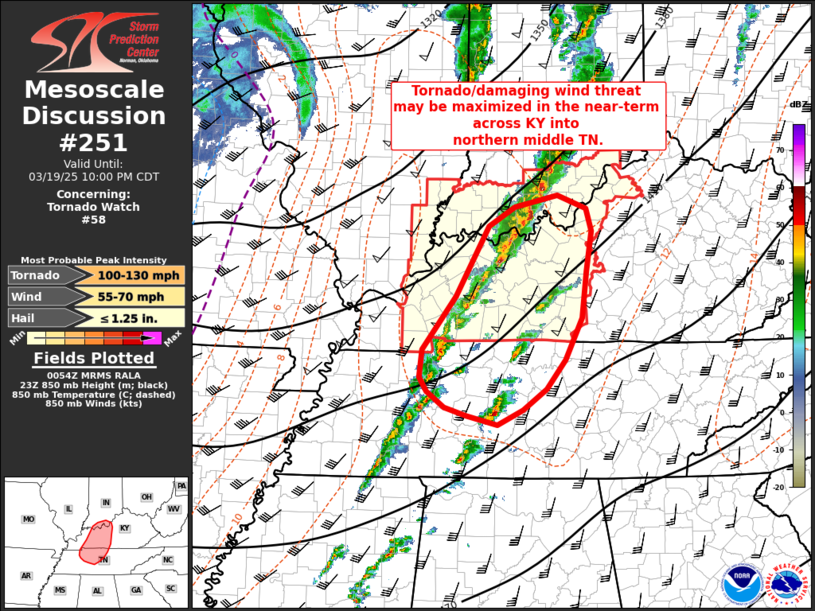
Tornado Watch Number 58
NWS Storm Prediction Center Norman OK
315 PM CDT Wed Mar 19 2025
The NWS Storm Prediction Center has issued a
* Tornado Watch for portions of
Southern Illinois
Southern Indiana
Western and Central Kentucky
* Effective this Wednesday afternoon and evening from 315 PM
until 1100 PM CDT.
* Primary threats include...
A few tornadoes possible
Scattered damaging wind gusts to 70 mph possible
Scattered large hail events to 1.5 inches in diameter possible
SUMMARY...A band of severe thunderstorms is expected to move
eastward across the watch area from late afternoon into this
evening. These storms may produce a few tornadoes, scattered wind
damage, and hail.
The tornado watch area is approximately along and 70 statute miles
north and south of a line from 70 miles west southwest of Evansville
IN to 20 miles south of Louisville KY. For a complete depiction of
the watch see the associated watch outline update (WOUS64 KWNS
WOU8).
PRECAUTIONARY/PREPAREDNESS ACTIONS...
REMEMBER...A Tornado Watch means conditions are favorable for
tornadoes and severe thunderstorms in and close to the watch
area. Persons in these areas should be on the lookout for
threatening weather conditions and listen for later statements
and possible warnings.
&&
OTHER WATCH INFORMATION...CONTINUE...WW 57...
AVIATION...Tornadoes and a few severe thunderstorms with hail
surface and aloft to 1.5 inches. Extreme turbulence and surface wind
gusts to 60 knots. A few cumulonimbi with maximum tops to 400. Mean
storm motion vector 24035.
...Leitman

   SEL8

   URGENT - IMMEDIATE BROADCAST REQUESTED
   Tornado Watch Number 58
   NWS Storm Prediction Center Norman OK
   315 PM CDT Wed Mar 19 2025

   The NWS Storm Prediction Center has issued a

   * Tornado Watch for portions of
     Southern Illinois
     Southern Indiana
     Western and Central Kentucky

   * Effective this Wednesday afternoon and evening from 315 PM
     until 1100 PM CDT.

   * Primary threats include...
     A few tornadoes possible
     Scattered damaging wind gusts to 70 mph possible
     Scattered large hail events to 1.5 inches in diameter possible

   SUMMARY...A band of severe thunderstorms is expected to move
   eastward across the watch area from late afternoon into this
   evening. These storms may produce a few tornadoes, scattered wind
   damage, and hail.

   The tornado watch area is approximately along and 70 statute miles
   north and south of a line from 70 miles west southwest of Evansville
   IN to 20 miles south of Louisville KY. For a complete depiction of
   the watch see the associated watch outline update (WOUS64 KWNS
   WOU8).

   PRECAUTIONARY/PREPAREDNESS ACTIONS...

   REMEMBER...A Tornado Watch means conditions are favorable for
   tornadoes and severe thunderstorms in and close to the watch
   area. Persons in these areas should be on the lookout for
   threatening weather conditions and listen for later statements
   and possible warnings.

   &&

   OTHER WATCH INFORMATION...CONTINUE...WW 57...

   AVIATION...Tornadoes and a few severe thunderstorms with hail
   surface and aloft to 1.5 inches. Extreme turbulence and surface wind
   gusts to 60 knots. A few cumulonimbi with maximum tops to 400. Mean
   storm motion vector 24035.

   ...Leitman
 Note:
The Aviation Watch (SAW) product is an approximation to the watch area.
The actual watch is depicted by the shaded areas.
Note:
The Aviation Watch (SAW) product is an approximation to the watch area.
The actual watch is depicted by the shaded areas.
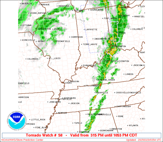
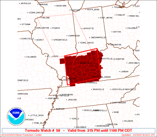
   SAW8
   WW 58 TORNADO IL IN KY 192015Z - 200400Z
   AXIS..70 STATUTE MILES NORTH AND SOUTH OF LINE..
   70WSW EVV/EVANSVILLE IN/ - 20S SDF/LOUISVILLE KY/
   ..AVIATION COORDS.. 60NM N/S /48WSW PXV - 14SSW IIU/
   HAIL SURFACE AND ALOFT..1.5 INCHES. WIND GUSTS..60 KNOTS.
   MAX TOPS TO 400. MEAN STORM MOTION VECTOR 24035.

   LAT...LON 38658871 38908573 36888573 36628871

   THIS IS AN APPROXIMATION TO THE WATCH AREA.  FOR A
   COMPLETE DEPICTION OF THE WATCH SEE WOUS64 KWNS
   FOR WOU8.
Watch 58 Status Report Messages:
STATUS REPORT #6 ON WW 58

VALID 200245Z - 200340Z

SEVERE WEATHER THREAT CONTINUES RIGHT OF A LINE FROM 30 SW BWG TO
50 N SDF.

..HART..03/20/25

ATTN...WFO...PAH...LMK...

&&

STATUS REPORT FOR WT 58

SEVERE WEATHER THREAT CONTINUES FOR THE FOLLOWING AREAS

INC077-200340-

IN
.    INDIANA COUNTIES INCLUDED ARE

JEFFERSON
$$


KYC003-009-029-061-085-093-099-103-111-123-185-213-223-227-
200340-

KY
.    KENTUCKY COUNTIES INCLUDED ARE

ALLEN		     BARREN		 BULLITT
EDMONSON	     GRAYSON		 HARDIN
HART		     HENRY		 JEFFERSON
LARUE		     OLDHAM		 SIMPSON
TRIMBLE 	     WARREN
$$


THE WATCH STATUS MESSAGE IS FOR GUIDANCE PURPOSES ONLY.  PLEASE
REFER TO WATCH COUNTY NOTIFICATION STATEMENTS FOR OFFICIAL
INFORMATION ON COUNTIES...INDEPENDENT CITIES AND MARINE ZONES
CLEARED FROM SEVERE THUNDERSTORM AND TORNADO WATCHES.
$$

STATUS REPORT #5 ON WW 58

VALID 200135Z - 200240Z

SEVERE WEATHER THREAT CONTINUES RIGHT OF A LINE FROM 5 WNW HOP TO
20 E OWB TO 40 ESE BMG.

..GOSS..03/20/25

ATTN...WFO...PAH...LMK...

&&

STATUS REPORT FOR WT 58

SEVERE WEATHER THREAT CONTINUES FOR THE FOLLOWING AREAS

INC019-043-061-077-143-175-200240-

IN
.    INDIANA COUNTIES INCLUDED ARE

CLARK		     FLOYD		 HARRISON
JEFFERSON	     SCOTT		 WASHINGTON
$$


KYC003-009-027-029-031-047-059-061-085-091-093-099-103-111-123-
141-163-177-183-185-213-219-223-227-200240-

KY
.    KENTUCKY COUNTIES INCLUDED ARE

ALLEN		     BARREN		 BRECKINRIDGE
BULLITT 	     BUTLER		 CHRISTIAN
DAVIESS 	     EDMONSON		 GRAYSON
HANCOCK 	     HARDIN		 HART
HENRY		     JEFFERSON		 LARUE
LOGAN		     MEADE		 MUHLENBERG
OHIO		     OLDHAM		 SIMPSON
TODD		     TRIMBLE		 WARREN
$$


THE WATCH STATUS MESSAGE IS FOR GUIDANCE PURPOSES ONLY.  PLEASE
REFER TO WATCH COUNTY NOTIFICATION STATEMENTS FOR OFFICIAL
INFORMATION ON COUNTIES...INDEPENDENT CITIES AND MARINE ZONES
CLEARED FROM SEVERE THUNDERSTORM AND TORNADO WATCHES.
$$

STATUS REPORT #4 ON WW 58

VALID 200040Z - 200140Z

SEVERE WEATHER THREAT CONTINUES RIGHT OF A LINE FROM 55 NNE MKL
TO 15 WSW OWB TO 25 NNE EVV TO 45 SSE MTO.

FOR ADDITIONAL INFORMATION SEE MESOSCALE DISCUSSION 248

..MOORE..03/20/25

ATTN...WFO...PAH...LMK...

&&

STATUS REPORT FOR WT 58

SEVERE WEATHER THREAT CONTINUES FOR THE FOLLOWING AREAS

INC019-025-037-043-061-077-117-123-125-143-147-173-175-200140-

IN
.    INDIANA COUNTIES INCLUDED ARE

CLARK		     CRAWFORD		 DUBOIS
FLOYD		     HARRISON		 JEFFERSON
ORANGE		     PERRY		 PIKE
SCOTT		     SPENCER		 WARRICK
WASHINGTON
$$


KYC003-009-027-029-031-047-059-061-085-091-093-099-103-107-111-
123-141-149-163-177-183-185-213-219-221-223-227-200140-

KY
.    KENTUCKY COUNTIES INCLUDED ARE

ALLEN		     BARREN		 BRECKINRIDGE
BULLITT 	     BUTLER		 CHRISTIAN
DAVIESS 	     EDMONSON		 GRAYSON
HANCOCK 	     HARDIN		 HART
HENRY		     HOPKINS		 JEFFERSON
LARUE		     LOGAN		 MCLEAN
MEADE		     MUHLENBERG 	 OHIO
OLDHAM		     SIMPSON		 TODD
TRIGG		     TRIMBLE		 WARREN
$$


THE WATCH STATUS MESSAGE IS FOR GUIDANCE PURPOSES ONLY.  PLEASE
REFER TO WATCH COUNTY NOTIFICATION STATEMENTS FOR OFFICIAL
INFORMATION ON COUNTIES...INDEPENDENT CITIES AND MARINE ZONES
CLEARED FROM SEVERE THUNDERSTORM AND TORNADO WATCHES.
$$

STATUS REPORT #3 ON WW 58

VALID 192355Z - 200040Z

SEVERE WEATHER THREAT CONTINUES RIGHT OF A LINE FROM 40 ENE DYR
TO 25 NNE SLO.

FOR ADDITIONAL INFORMATION SEE MESOSCALE DISCUSSION 248

..MOORE..03/19/25

ATTN...WFO...PAH...LMK...

&&

STATUS REPORT FOR WT 58

SEVERE WEATHER THREAT CONTINUES FOR THE FOLLOWING AREAS

ILC047-059-065-069-151-165-185-191-193-200040-

IL
.    ILLINOIS COUNTIES INCLUDED ARE

EDWARDS 	     GALLATIN		 HAMILTON
HARDIN		     POPE		 SALINE
WABASH		     WAYNE		 WHITE
$$


INC019-025-037-043-051-061-077-117-123-125-129-143-147-163-173-
175-200040-

IN
.    INDIANA COUNTIES INCLUDED ARE

CLARK		     CRAWFORD		 DUBOIS
FLOYD		     GIBSON		 HARRISON
JEFFERSON	     ORANGE		 PERRY
PIKE		     POSEY		 SCOTT
SPENCER 	     VANDERBURGH	 WARRICK
WASHINGTON
$$


KYC003-009-027-029-031-033-035-047-055-059-061-085-091-093-099-
101-103-107-111-123-139-141-143-149-157-163-177-183-185-213-219-
221-223-225-227-233-200040-

KY
.    KENTUCKY COUNTIES INCLUDED ARE

ALLEN		     BARREN		 BRECKINRIDGE
BULLITT 	     BUTLER		 CALDWELL
CALLOWAY	     CHRISTIAN		 CRITTENDEN
DAVIESS 	     EDMONSON		 GRAYSON
HANCOCK 	     HARDIN		 HART
HENDERSON	     HENRY		 HOPKINS
JEFFERSON	     LARUE		 LIVINGSTON
LOGAN		     LYON		 MCLEAN
MARSHALL	     MEADE		 MUHLENBERG
OHIO		     OLDHAM		 SIMPSON
TODD		     TRIGG		 TRIMBLE
UNION		     WARREN		 WEBSTER
$$


THE WATCH STATUS MESSAGE IS FOR GUIDANCE PURPOSES ONLY.  PLEASE
REFER TO WATCH COUNTY NOTIFICATION STATEMENTS FOR OFFICIAL
INFORMATION ON COUNTIES...INDEPENDENT CITIES AND MARINE ZONES
CLEARED FROM SEVERE THUNDERSTORM AND TORNADO WATCHES.
$$

STATUS REPORT #2 ON WW 58

VALID 192235Z - 192340Z

THE SEVERE WEATHER THREAT CONTINUES ACROSS THE ENTIRE WATCH AREA.

..GOSS..03/19/25

ATTN...WFO...PAH...LMK...

&&

STATUS REPORT FOR WT 58

SEVERE WEATHER THREAT CONTINUES FOR THE FOLLOWING AREAS

ILC047-059-065-069-081-151-165-185-191-193-192340-

IL
.    ILLINOIS COUNTIES INCLUDED ARE

EDWARDS 	     GALLATIN		 HAMILTON
HARDIN		     JEFFERSON		 POPE
SALINE		     WABASH		 WAYNE
WHITE
$$


INC019-025-037-043-051-061-117-123-125-129-143-147-163-173-175-
192340-

IN
.    INDIANA COUNTIES INCLUDED ARE

CLARK		     CRAWFORD		 DUBOIS
FLOYD		     GIBSON		 HARRISON
ORANGE		     PERRY		 PIKE
POSEY		     SCOTT		 SPENCER
VANDERBURGH	     WARRICK		 WASHINGTON
$$


KYC003-009-027-029-031-033-035-047-055-059-061-085-091-093-099-
101-107-111-123-139-141-143-149-157-163-177-183-185-213-219-221-
225-227-233-192340-

KY
.    KENTUCKY COUNTIES INCLUDED ARE

ALLEN		     BARREN		 BRECKINRIDGE
BULLITT 	     BUTLER		 CALDWELL
CALLOWAY	     CHRISTIAN		 CRITTENDEN
DAVIESS 	     EDMONSON		 GRAYSON
HANCOCK 	     HARDIN		 HART
HENDERSON	     HOPKINS		 JEFFERSON
LARUE		     LIVINGSTON 	 LOGAN
LYON		     MCLEAN		 MARSHALL
MEADE		     MUHLENBERG 	 OHIO
OLDHAM		     SIMPSON		 TODD
TRIGG		     UNION		 WARREN
WEBSTER
$$


THE WATCH STATUS MESSAGE IS FOR GUIDANCE PURPOSES ONLY.  PLEASE
REFER TO WATCH COUNTY NOTIFICATION STATEMENTS FOR OFFICIAL
INFORMATION ON COUNTIES...INDEPENDENT CITIES AND MARINE ZONES
CLEARED FROM SEVERE THUNDERSTORM AND TORNADO WATCHES.
$$

STATUS REPORT #1 ON WW 58

VALID 192200Z - 192340Z

THE SEVERE WEATHER THREAT CONTINUES ACROSS THE ENTIRE WATCH AREA.

..MOORE..03/19/25

ATTN...WFO...PAH...LMK...

&&

STATUS REPORT FOR WT 58

SEVERE WEATHER THREAT CONTINUES FOR THE FOLLOWING AREAS

ILC047-059-065-069-081-151-165-185-191-193-192340-

IL
.    ILLINOIS COUNTIES INCLUDED ARE

EDWARDS 	     GALLATIN		 HAMILTON
HARDIN		     JEFFERSON		 POPE
SALINE		     WABASH		 WAYNE
WHITE
$$


INC019-025-037-043-051-061-117-123-125-129-143-147-163-173-175-
192340-

IN
.    INDIANA COUNTIES INCLUDED ARE

CLARK		     CRAWFORD		 DUBOIS
FLOYD		     GIBSON		 HARRISON
ORANGE		     PERRY		 PIKE
POSEY		     SCOTT		 SPENCER
VANDERBURGH	     WARRICK		 WASHINGTON
$$


KYC003-009-027-029-031-033-035-047-055-059-061-085-091-093-099-
101-107-111-123-139-141-143-149-157-163-177-183-185-213-219-221-
225-227-233-192340-

KY
.    KENTUCKY COUNTIES INCLUDED ARE

ALLEN		     BARREN		 BRECKINRIDGE
BULLITT 	     BUTLER		 CALDWELL
CALLOWAY	     CHRISTIAN		 CRITTENDEN
DAVIESS 	     EDMONSON		 GRAYSON
HANCOCK 	     HARDIN		 HART
HENDERSON	     HOPKINS		 JEFFERSON
LARUE		     LIVINGSTON 	 LOGAN
LYON		     MCLEAN		 MARSHALL
MEADE		     MUHLENBERG 	 OHIO
OLDHAM		     SIMPSON		 TODD
TRIGG		     UNION		 WARREN
WEBSTER
$$


THE WATCH STATUS MESSAGE IS FOR GUIDANCE PURPOSES ONLY.  PLEASE
REFER TO WATCH COUNTY NOTIFICATION STATEMENTS FOR OFFICIAL
INFORMATION ON COUNTIES...INDEPENDENT CITIES AND MARINE ZONES
CLEARED FROM SEVERE THUNDERSTORM AND TORNADO WATCHES.
$$
Note:
Click for Complete Product Text.
Tornadoes
Probability of 2 or more tornadoes
|
Mod (50%)
|
Probability of 1 or more strong (EF2-EF5) tornadoes
|
Low (20%)
|
Wind
Probability of 10 or more severe wind events
|
Mod (50%)
|
Probability of 1 or more wind events > 65 knots
|
Low (20%)
|
Hail
Probability of 10 or more severe hail events
|
Mod (40%)
|
Probability of 1 or more hailstones > 2 inches
|
Low (20%)
|
Combined Severe Hail/Wind
Probability of 6 or more combined severe hail/wind events
|
High (80%)
|
For each watch, probabilities for particular events inside the watch
(listed above in each table) are determined by the issuing forecaster.
The "Low" category contains probability values ranging from less than 2%
to 20% (EF2-EF5 tornadoes), less than 5% to 20% (all other probabilities),
"Moderate" from 30% to 60%, and "High" from 70% to greater than 95%.
High values are bolded and lighter in color to provide awareness of
an increased threat for a particular event.


 @NWSSPC