Note:
The expiration time in the watch graphic is amended if the watch is
replaced, cancelled or extended.
Note:
Note:
The expiration time in the watch graphic is amended if the watch is
replaced, cancelled or extended.
Note: Click for
Watch Status Reports.
SEL0
URGENT - IMMEDIATE BROADCAST REQUESTED
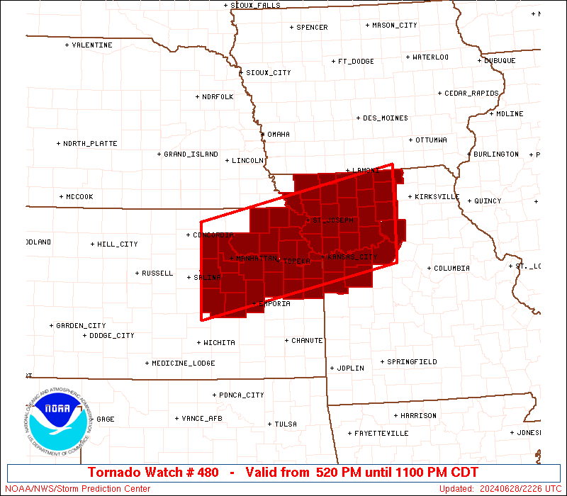
Tornado Watch Number 480
NWS Storm Prediction Center Norman OK
520 PM CDT Fri Jun 28 2024
The NWS Storm Prediction Center has issued a
* Tornado Watch for portions of
Central into Eastern Kansas
Western and Northern Missouri
* Effective this Friday afternoon and evening from 520 PM until
1100 PM CDT.
* Primary threats include...
A couple tornadoes possible
Scattered damaging winds likely with isolated significant gusts
to 75 mph possible
Scattered large hail likely with isolated very large hail events
to 2.5 inches in diameter possible
SUMMARY...Isolated to scattered severe thunderstorms are forecast to
develop into the evening across the Watch area. A few supercells
are possible, and an accompanying risk for large to very large hail
(1 to 2.5 inches in diameter) and a threat for a couple of
tornadoes, will potentially maximize during the early to mid
evening. If a cluster of storms can develop later this evening, a
risk for severe gusts (60-75 mph) will become an increasing severe
hazard, in addition to a threat for hail.
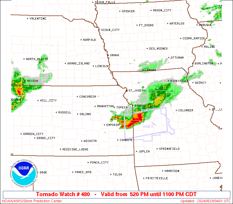
The tornado watch area is approximately along and 60 statute miles
north and south of a line from 35 miles east of Chillicothe MO to 40
miles west southwest of Manhattan KS. For a complete depiction of
the watch see the associated watch outline update (WOUS64 KWNS
WOU0).
PRECAUTIONARY/PREPAREDNESS ACTIONS...
REMEMBER...A Tornado Watch means conditions are favorable for
tornadoes and severe thunderstorms in and close to the watch
area. Persons in these areas should be on the lookout for
threatening weather conditions and listen for later statements
and possible warnings.
&&
AVIATION...Tornadoes and a few severe thunderstorms with hail
surface and aloft to 2.5 inches. Extreme turbulence and surface wind
gusts to 65 knots. A few cumulonimbi with maximum tops to 550. Mean
storm motion vector 27020.
...Smith
   SEL0

   URGENT - IMMEDIATE BROADCAST REQUESTED
   Tornado Watch Number 480
   NWS Storm Prediction Center Norman OK
   520 PM CDT Fri Jun 28 2024

   The NWS Storm Prediction Center has issued a

   * Tornado Watch for portions of
     Central into Eastern Kansas
     Western and Northern Missouri

   * Effective this Friday afternoon and evening from 520 PM until
     1100 PM CDT.

   * Primary threats include...
     A couple tornadoes possible
     Scattered damaging winds likely with isolated significant gusts
       to 75 mph possible
     Scattered large hail likely with isolated very large hail events
       to 2.5 inches in diameter possible

   SUMMARY...Isolated to scattered severe thunderstorms are forecast to
   develop into the evening across the Watch area.  A few supercells
   are possible, and an accompanying risk for large to very large hail
   (1 to 2.5 inches in diameter) and a threat for a couple of
   tornadoes, will potentially maximize during the early to mid
   evening.  If a cluster of storms can develop later this evening, a
   risk for severe gusts (60-75 mph) will become an increasing severe
   hazard, in addition to a threat for hail.

   The tornado watch area is approximately along and 60 statute miles
   north and south of a line from 35 miles east of Chillicothe MO to 40
   miles west southwest of Manhattan KS. For a complete depiction of
   the watch see the associated watch outline update (WOUS64 KWNS
   WOU0).

   PRECAUTIONARY/PREPAREDNESS ACTIONS...

   REMEMBER...A Tornado Watch means conditions are favorable for
   tornadoes and severe thunderstorms in and close to the watch
   area. Persons in these areas should be on the lookout for
   threatening weather conditions and listen for later statements
   and possible warnings.

   &&

   AVIATION...Tornadoes and a few severe thunderstorms with hail
   surface and aloft to 2.5 inches. Extreme turbulence and surface wind
   gusts to 65 knots. A few cumulonimbi with maximum tops to 550. Mean
   storm motion vector 27020.

   ...Smith
 Note:
The Aviation Watch (SAW) product is an approximation to the watch area.
The actual watch is depicted by the shaded areas.
Note:
The Aviation Watch (SAW) product is an approximation to the watch area.
The actual watch is depicted by the shaded areas.
   SAW0
   WW 480 TORNADO KS MO 282220Z - 290400Z
   AXIS..60 STATUTE MILES NORTH AND SOUTH OF LINE..
   35E CDJ/CHILLICOTHE MO/ - 40WSW MHK/MANHATTAN KS/
   ..AVIATION COORDS.. 50NM N/S /25SW IRK - 12E SLN/
   HAIL SURFACE AND ALOFT..2.5 INCHES. WIND GUSTS..65 KNOTS.
   MAX TOPS TO 550. MEAN STORM MOTION VECTOR 27020.

   LAT...LON 38959292 38049736 39779736 40689292

   THIS IS AN APPROXIMATION TO THE WATCH AREA.  FOR A
   COMPLETE DEPICTION OF THE WATCH SEE WOUS64 KWNS
   FOR WOU0.
Watch 480 Status Report Messages:
STATUS REPORT #3 ON WW 480

VALID 290220Z - 290340Z

SEVERE WEATHER THREAT CONTINUES RIGHT OF A LINE FROM EMP TO 25
WSW MHK TO 20 W FNB.

..GOSS..06/29/24

ATTN...WFO...EAX...TOP...ICT...

&&

STATUS REPORT FOR WT 480

SEVERE WEATHER THREAT CONTINUES FOR THE FOLLOWING AREAS

KSC003-005-013-031-041-043-045-059-061-085-087-091-103-107-111-
121-127-131-139-149-161-177-197-209-290340-

KS
.    KANSAS COUNTIES INCLUDED ARE

ANDERSON	     ATCHISON		 BROWN
COFFEY		     DICKINSON		 DONIPHAN
DOUGLAS 	     FRANKLIN		 GEARY
JACKSON 	     JEFFERSON		 JOHNSON
LEAVENWORTH	     LINN		 LYON
MIAMI		     MORRIS		 NEMAHA
OSAGE		     POTTAWATOMIE	 RILEY
SHAWNEE 	     WABAUNSEE		 WYANDOTTE
$$


MOC003-021-025-033-037-041-047-049-061-063-075-079-081-087-095-
101-107-115-117-129-147-165-171-177-195-211-227-290340-

MO
.    MISSOURI COUNTIES INCLUDED ARE

ANDREW		     BUCHANAN		 CALDWELL
CARROLL 	     CASS		 CHARITON
CLAY		     CLINTON		 DAVIESS
DEKALB		     GENTRY		 GRUNDY
HARRISON	     HOLT		 JACKSON
JOHNSON 	     LAFAYETTE		 LINN
LIVINGSTON	     MERCER		 NODAWAY
PLATTE		     PUTNAM		 RAY
SALINE		     SULLIVAN		 WORTH
$$


THE WATCH STATUS MESSAGE IS FOR GUIDANCE PURPOSES ONLY.  PLEASE
REFER TO WATCH COUNTY NOTIFICATION STATEMENTS FOR OFFICIAL
INFORMATION ON COUNTIES...INDEPENDENT CITIES AND MARINE ZONES
CLEARED FROM SEVERE THUNDERSTORM AND TORNADO WATCHES.
$$

STATUS REPORT #2 ON WW 480

VALID 290035Z - 290140Z

SEVERE WEATHER THREAT CONTINUES RIGHT OF A LINE FROM 20 NNE SLN
TO 30 ESE BIE.

FOR ADDITIONAL INFORMATION SEE MESOSCALE DISCUSSION 1465

..SUPINIE..06/29/24

ATTN...WFO...EAX...TOP...ICT...

&&

STATUS REPORT FOR WT 480

SEVERE WEATHER THREAT CONTINUES FOR THE FOLLOWING AREAS

KSC005-013-017-041-043-045-059-061-085-087-091-103-111-115-121-
127-131-139-149-161-177-197-209-290140-

KS
.    KANSAS COUNTIES INCLUDED ARE

ATCHISON	     BROWN		 CHASE
DICKINSON	     DONIPHAN		 DOUGLAS
FRANKLIN	     GEARY		 JACKSON
JEFFERSON	     JOHNSON		 LEAVENWORTH
LYON		     MARION		 MIAMI
MORRIS		     NEMAHA		 OSAGE
POTTAWATOMIE	     RILEY		 SHAWNEE
WABAUNSEE	     WYANDOTTE
$$


MOC003-021-025-033-037-041-047-049-061-063-075-079-081-087-095-
101-107-115-117-129-147-165-171-177-195-211-227-290140-

MO
.    MISSOURI COUNTIES INCLUDED ARE

ANDREW		     BUCHANAN		 CALDWELL
CARROLL 	     CASS		 CHARITON
CLAY		     CLINTON		 DAVIESS
DEKALB		     GENTRY		 GRUNDY
HARRISON	     HOLT		 JACKSON
JOHNSON 	     LAFAYETTE		 LINN
LIVINGSTON	     MERCER		 NODAWAY
PLATTE		     PUTNAM		 RAY
SALINE		     SULLIVAN		 WORTH
$$


THE WATCH STATUS MESSAGE IS FOR GUIDANCE PURPOSES ONLY.  PLEASE
REFER TO WATCH COUNTY NOTIFICATION STATEMENTS FOR OFFICIAL
INFORMATION ON COUNTIES...INDEPENDENT CITIES AND MARINE ZONES
CLEARED FROM SEVERE THUNDERSTORM AND TORNADO WATCHES.
$$

STATUS REPORT #1 ON WW 480

VALID 282330Z - 290040Z

THE SEVERE WEATHER THREAT CONTINUES ACROSS THE ENTIRE WATCH AREA.

..SUPINIE..06/28/24

ATTN...WFO...EAX...TOP...ICT...

&&

STATUS REPORT FOR WT 480

SEVERE WEATHER THREAT CONTINUES FOR THE FOLLOWING AREAS

KSC005-013-017-027-041-043-045-059-061-085-087-091-103-111-115-
121-127-131-139-149-161-177-197-209-290040-

KS
.    KANSAS COUNTIES INCLUDED ARE

ATCHISON	     BROWN		 CHASE
CLAY		     DICKINSON		 DONIPHAN
DOUGLAS 	     FRANKLIN		 GEARY
JACKSON 	     JEFFERSON		 JOHNSON
LEAVENWORTH	     LYON		 MARION
MIAMI		     MORRIS		 NEMAHA
OSAGE		     POTTAWATOMIE	 RILEY
SHAWNEE 	     WABAUNSEE		 WYANDOTTE
$$


MOC003-021-025-033-037-041-047-049-061-063-075-079-081-087-095-
101-107-115-117-129-147-165-171-177-195-211-227-290040-

MO
.    MISSOURI COUNTIES INCLUDED ARE

ANDREW		     BUCHANAN		 CALDWELL
CARROLL 	     CASS		 CHARITON
CLAY		     CLINTON		 DAVIESS
DEKALB		     GENTRY		 GRUNDY
HARRISON	     HOLT		 JACKSON
JOHNSON 	     LAFAYETTE		 LINN
LIVINGSTON	     MERCER		 NODAWAY
PLATTE		     PUTNAM		 RAY
SALINE		     SULLIVAN		 WORTH
$$


THE WATCH STATUS MESSAGE IS FOR GUIDANCE PURPOSES ONLY.  PLEASE
REFER TO WATCH COUNTY NOTIFICATION STATEMENTS FOR OFFICIAL
INFORMATION ON COUNTIES...INDEPENDENT CITIES AND MARINE ZONES
CLEARED FROM SEVERE THUNDERSTORM AND TORNADO WATCHES.
$$
Note:
Click for Complete Product Text.
Tornadoes
Probability of 2 or more tornadoes
|
Mod (40%)
|
Probability of 1 or more strong (EF2-EF5) tornadoes
|
Low (20%)
|
Wind
Probability of 10 or more severe wind events
|
Mod (60%)
|
Probability of 1 or more wind events > 65 knots
|
Mod (30%)
|
Hail
Probability of 10 or more severe hail events
|
Mod (60%)
|
Probability of 1 or more hailstones > 2 inches
|
Mod (30%)
|
Combined Severe Hail/Wind
Probability of 6 or more combined severe hail/wind events
|
High (>95%)
|
For each watch, probabilities for particular events inside the watch
(listed above in each table) are determined by the issuing forecaster.
The "Low" category contains probability values ranging from less than 2%
to 20% (EF2-EF5 tornadoes), less than 5% to 20% (all other probabilities),
"Moderate" from 30% to 60%, and "High" from 70% to greater than 95%.
High values are bolded and lighter in color to provide awareness of
an increased threat for a particular event.


 @NWSSPC