 Note:
The expiration time in the watch graphic is amended if the watch is
replaced, cancelled or extended.
Note:
Note:
The expiration time in the watch graphic is amended if the watch is
replaced, cancelled or extended.
Note: Click for
Watch Status Reports.
SEL8
URGENT - IMMEDIATE BROADCAST REQUESTED
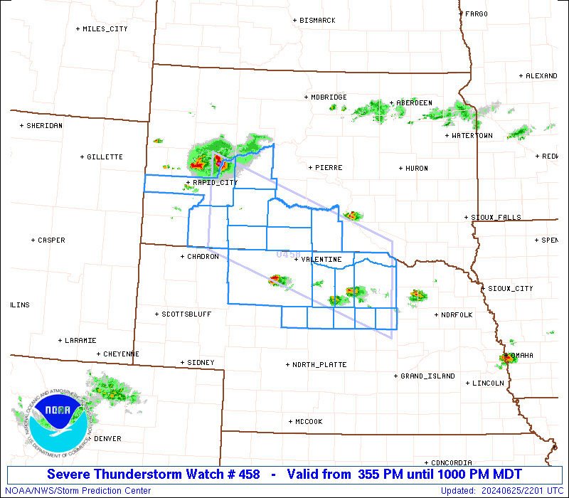
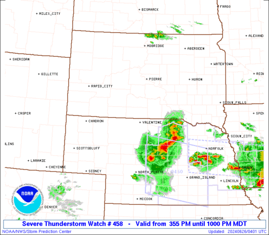
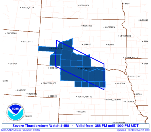
Severe Thunderstorm Watch Number 458
NWS Storm Prediction Center Norman OK
355 PM MDT Tue Jun 25 2024
The NWS Storm Prediction Center has issued a
* Severe Thunderstorm Watch for portions of
Northern Nebraska
Southwest and south-central South Dakota
* Effective this Tuesday afternoon and evening from 355 PM until
1000 PM MDT.
* Primary threats include...
Scattered damaging winds and isolated significant gusts to 75
mph possible
Scattered large hail and isolated very large hail events to 2.5
inches in diameter possible
A tornado or two possible
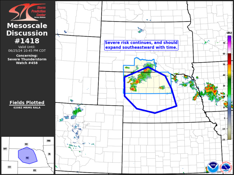
SUMMARY...Supercells should continue to pose a threat for large hail
around 1.5-2.5 inches in diameter, along with severe/damaging winds
of 60-75 mph, as they move east-southeastward this afternoon and
evening.
The severe thunderstorm watch area is approximately along and 55
statute miles north and south of a line from 50 miles west southwest
of Philip SD to 15 miles east southeast of Oneill NE. For a complete
depiction of the watch see the associated watch outline update
(WOUS64 KWNS WOU8).
PRECAUTIONARY/PREPAREDNESS ACTIONS...
REMEMBER...A Severe Thunderstorm Watch means conditions are
favorable for severe thunderstorms in and close to the watch area.
Persons in these areas should be on the lookout for threatening
weather conditions and listen for later statements and possible
warnings. Severe thunderstorms can and occasionally do produce
tornadoes.
&&
OTHER WATCH INFORMATION...CONTINUE...WW 457...
AVIATION...A few severe thunderstorms with hail surface and aloft to
2.5 inches. Extreme turbulence and surface wind gusts to 65 knots. A
few cumulonimbi with maximum tops to 550. Mean storm motion vector
30035.
...Gleason

   SEL8

   URGENT - IMMEDIATE BROADCAST REQUESTED
   Severe Thunderstorm Watch Number 458
   NWS Storm Prediction Center Norman OK
   355 PM MDT Tue Jun 25 2024

   The NWS Storm Prediction Center has issued a

   * Severe Thunderstorm Watch for portions of
     Northern Nebraska
     Southwest and south-central South Dakota

   * Effective this Tuesday afternoon and evening from 355 PM until
     1000 PM MDT.

   * Primary threats include...
     Scattered damaging winds and isolated significant gusts to 75
       mph possible
     Scattered large hail and isolated very large hail events to 2.5
       inches in diameter possible
     A tornado or two possible

   SUMMARY...Supercells should continue to pose a threat for large hail
   around 1.5-2.5 inches in diameter, along with severe/damaging winds
   of 60-75 mph, as they move east-southeastward this afternoon and
   evening.

   The severe thunderstorm watch area is approximately along and 55
   statute miles north and south of a line from 50 miles west southwest
   of Philip SD to 15 miles east southeast of Oneill NE. For a complete
   depiction of the watch see the associated watch outline update
   (WOUS64 KWNS WOU8).

   PRECAUTIONARY/PREPAREDNESS ACTIONS...

   REMEMBER...A Severe Thunderstorm Watch means conditions are
   favorable for severe thunderstorms in and close to the watch area.
   Persons in these areas should be on the lookout for threatening
   weather conditions and listen for later statements and possible
   warnings. Severe thunderstorms can and occasionally do produce
   tornadoes.

   &&

   OTHER WATCH INFORMATION...CONTINUE...WW 457...

   AVIATION...A few severe thunderstorms with hail surface and aloft to
   2.5 inches. Extreme turbulence and surface wind gusts to 65 knots. A
   few cumulonimbi with maximum tops to 550. Mean storm motion vector
   30035.

   ...Gleason
 Note:
The Aviation Watch (SAW) product is an approximation to the watch area.
The actual watch is depicted by the shaded areas.
Note:
The Aviation Watch (SAW) product is an approximation to the watch area.
The actual watch is depicted by the shaded areas.
   SAW8
   WW 458 SEVERE TSTM NE SD 252155Z - 260400Z
   AXIS..55 STATUTE MILES NORTH AND SOUTH OF LINE..
   50WSW PHP/PHILIP SD/ - 15ESE ONL/ONEILL NE/
   ..AVIATION COORDS.. 50NM N/S /24ESE RAP - 13ESE ONL/
   HAIL SURFACE AND ALOFT..2.5 INCHES. WIND GUSTS..65 KNOTS.
   MAX TOPS TO 550. MEAN STORM MOTION VECTOR 30035.

   LAT...LON 44570253 43189841 41599841 42970253

   THIS IS AN APPROXIMATION TO THE WATCH AREA.  FOR A
   COMPLETE DEPICTION OF THE WATCH SEE WOUS64 KWNS
   FOR WOU8.
Watch 458 Status Report Messages:
STATUS REPORT #2 ON WW 458

VALID 260335Z - 260440Z

SEVERE WEATHER THREAT CONTINUES RIGHT OF A LINE FROM 20 SSE MHN
TO 40 ENE ANW TO 40 NNE ONL.

..GOSS..06/26/24

ATTN...WFO...LBF...UNR...

&&

STATUS REPORT FOR WS 458

SEVERE WEATHER THREAT CONTINUES FOR THE FOLLOWING AREAS

NEC009-015-017-071-089-115-149-171-183-260440-

NE
.    NEBRASKA COUNTIES INCLUDED ARE

BLAINE		     BOYD		 BROWN
GARFIELD	     HOLT		 LOUP
ROCK		     THOMAS		 WHEELER
$$


THE WATCH STATUS MESSAGE IS FOR GUIDANCE PURPOSES ONLY.  PLEASE
REFER TO WATCH COUNTY NOTIFICATION STATEMENTS FOR OFFICIAL
INFORMATION ON COUNTIES...INDEPENDENT CITIES AND MARINE ZONES
CLEARED FROM SEVERE THUNDERSTORM AND TORNADO WATCHES.
$$

STATUS REPORT #1 ON WW 458

VALID 260140Z - 260240Z

SEVERE WEATHER THREAT CONTINUES RIGHT OF A LINE FROM 40 E CDR TO
25 SSW PHP TO 30 E PHP.

..GOSS..06/26/24

ATTN...WFO...LBF...UNR...

&&

STATUS REPORT FOR WS 458

SEVERE WEATHER THREAT CONTINUES FOR THE FOLLOWING AREAS

NEC009-015-017-031-071-075-089-091-103-115-149-171-183-260240-

NE
.    NEBRASKA COUNTIES INCLUDED ARE

BLAINE		     BOYD		 BROWN
CHERRY		     GARFIELD		 GRANT
HOLT		     HOOKER		 KEYA PAHA
LOUP		     ROCK		 THOMAS
WHEELER
$$


SDC007-095-121-123-260240-

SD
.    SOUTH DAKOTA COUNTIES INCLUDED ARE

BENNETT 	     MELLETTE		 TODD
TRIPP
$$


THE WATCH STATUS MESSAGE IS FOR GUIDANCE PURPOSES ONLY.  PLEASE
REFER TO WATCH COUNTY NOTIFICATION STATEMENTS FOR OFFICIAL
INFORMATION ON COUNTIES...INDEPENDENT CITIES AND MARINE ZONES
CLEARED FROM SEVERE THUNDERSTORM AND TORNADO WATCHES.
$$
Note:
Click for Complete Product Text.
Tornadoes
Probability of 2 or more tornadoes
|
Low (20%)
|
Probability of 1 or more strong (EF2-EF5) tornadoes
|
Low (5%)
|
Wind
Probability of 10 or more severe wind events
|
Mod (50%)
|
Probability of 1 or more wind events > 65 knots
|
Mod (30%)
|
Hail
Probability of 10 or more severe hail events
|
Mod (50%)
|
Probability of 1 or more hailstones > 2 inches
|
Mod (30%)
|
Combined Severe Hail/Wind
Probability of 6 or more combined severe hail/wind events
|
High (80%)
|
For each watch, probabilities for particular events inside the watch
(listed above in each table) are determined by the issuing forecaster.
The "Low" category contains probability values ranging from less than 2%
to 20% (EF2-EF5 tornadoes), less than 5% to 20% (all other probabilities),
"Moderate" from 30% to 60%, and "High" from 70% to greater than 95%.
High values are bolded and lighter in color to provide awareness of
an increased threat for a particular event.


 @NWSSPC