 Note:
The expiration time in the watch graphic is amended if the watch is
replaced, cancelled or extended.
Note:
Note:
The expiration time in the watch graphic is amended if the watch is
replaced, cancelled or extended.
Note: Click for
Watch Status Reports.
SEL4
URGENT - IMMEDIATE BROADCAST REQUESTED
Severe Thunderstorm Watch Number 434
NWS Storm Prediction Center Norman OK
145 PM CDT Tue Jun 18 2024
The NWS Storm Prediction Center has issued a
* Severe Thunderstorm Watch for portions of
Western and Northern Iowa
Northern Kansas
Southern and Eastern Nebraska
Far Southeast South Dakota
* Effective this Tuesday afternoon and evening from 145 PM until
800 PM CDT.
* Primary threats include...
Scattered damaging wind gusts to 70 mph likely
Scattered large hail and isolated very large hail events to 2
inches in diameter possible
A tornado or two possible
SUMMARY...Thunderstorms will continue to intensify along and east of
a cold front this afternoon, while posing a threat for mainly
severe/damaging winds around 60-70 mph along with 1-2 inch diameter
hail.
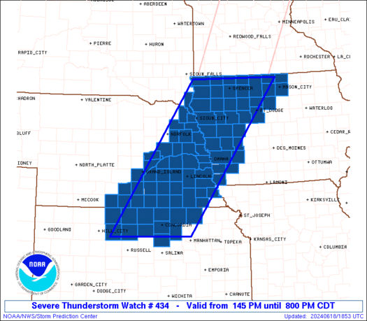
The severe thunderstorm watch area is approximately along and 75
statute miles east and west of a line from 20 miles north northeast
of Spencer IA to 30 miles southwest of Concordia KS. For a complete
depiction of the watch see the associated watch outline update
(WOUS64 KWNS WOU4).
PRECAUTIONARY/PREPAREDNESS ACTIONS...
REMEMBER...A Severe Thunderstorm Watch means conditions are
favorable for severe thunderstorms in and close to the watch area.
Persons in these areas should be on the lookout for threatening
weather conditions and listen for later statements and possible
warnings. Severe thunderstorms can and occasionally do produce
tornadoes.
&&
OTHER WATCH INFORMATION...CONTINUE...WW 433...
AVIATION...A few severe thunderstorms with hail surface and aloft to
2 inches. Extreme turbulence and surface wind gusts to 60 knots. A
few cumulonimbi with maximum tops to 500. Mean storm motion vector
26030.
...Gleason

   SEL4

   URGENT - IMMEDIATE BROADCAST REQUESTED
   Severe Thunderstorm Watch Number 434
   NWS Storm Prediction Center Norman OK
   145 PM CDT Tue Jun 18 2024

   The NWS Storm Prediction Center has issued a

   * Severe Thunderstorm Watch for portions of
     Western and Northern Iowa
     Northern Kansas
     Southern and Eastern Nebraska
     Far Southeast South Dakota

   * Effective this Tuesday afternoon and evening from 145 PM until
     800 PM CDT.

   * Primary threats include...
     Scattered damaging wind gusts to 70 mph likely
     Scattered large hail and isolated very large hail events to 2
       inches in diameter possible
     A tornado or two possible

   SUMMARY...Thunderstorms will continue to intensify along and east of
   a cold front this afternoon, while posing a threat for mainly
   severe/damaging winds around 60-70 mph along with 1-2 inch diameter
   hail.

   The severe thunderstorm watch area is approximately along and 75
   statute miles east and west of a line from 20 miles north northeast
   of Spencer IA to 30 miles southwest of Concordia KS. For a complete
   depiction of the watch see the associated watch outline update
   (WOUS64 KWNS WOU4).

   PRECAUTIONARY/PREPAREDNESS ACTIONS...

   REMEMBER...A Severe Thunderstorm Watch means conditions are
   favorable for severe thunderstorms in and close to the watch area.
   Persons in these areas should be on the lookout for threatening
   weather conditions and listen for later statements and possible
   warnings. Severe thunderstorms can and occasionally do produce
   tornadoes.

   &&

   OTHER WATCH INFORMATION...CONTINUE...WW 433...

   AVIATION...A few severe thunderstorms with hail surface and aloft to
   2 inches. Extreme turbulence and surface wind gusts to 60 knots. A
   few cumulonimbi with maximum tops to 500. Mean storm motion vector
   26030.

   ...Gleason
 Note:
The Aviation Watch (SAW) product is an approximation to the watch area.
The actual watch is depicted by the shaded areas.
Note:
The Aviation Watch (SAW) product is an approximation to the watch area.
The actual watch is depicted by the shaded areas.
   SAW4
   WW 434 SEVERE TSTM IA KS NE SD 181845Z - 190100Z
   AXIS..75 STATUTE MILES EAST AND WEST OF LINE..
   20NNE SPW/SPENCER IA/ - 30SW CNK/CONCORDIA KS/
   ..AVIATION COORDS.. 65NM E/W /59NNW FOD - 27NW SLN/
   HAIL SURFACE AND ALOFT..2 INCHES. WIND GUSTS..60 KNOTS.
   MAX TOPS TO 500. MEAN STORM MOTION VECTOR 26030.

   LAT...LON 43439350 39229665 39229945 43439649

   THIS IS AN APPROXIMATION TO THE WATCH AREA.  FOR A
   COMPLETE DEPICTION OF THE WATCH SEE WOUS64 KWNS
   FOR WOU4.
Watch 434 Status Report Messages:
STATUS REPORT #3 ON WW 434

VALID 190025Z - 190140Z

SEVERE WEATHER THREAT CONTINUES RIGHT OF A LINE FROM 25 NE RSL TO
40 ESE HSI TO 15 ENE EAR TO 30 W OLU TO 20 ENE LNK TO 30 NW DNS
TO 15 E SLB TO 20 E OTG.

FOR ADDITIONAL INFORMATION SEE MESOSCALE DISCUSSION 1328

PORTIONS OF WW 434 WILL BE EXTENDED IN TIME BEYOND 01Z.

..DEAN..06/19/24

ATTN...WFO...DMX...FSD...OAX...TOP...GID...

&&

STATUS REPORT FOR WS 434

SEVERE WEATHER THREAT CONTINUES FOR THE FOLLOWING AREAS

IAC009-025-027-029-033-047-063-071-081-085-091-093-109-129-137-
147-151-155-161-165-187-189-195-197-190140-

IA
.    IOWA COUNTIES INCLUDED ARE

AUDUBON 	     CALHOUN		 CARROLL
CASS		     CERRO GORDO	 CRAWFORD
EMMET		     FREMONT		 HANCOCK
HARRISON	     HUMBOLDT		 IDA
KOSSUTH 	     MILLS		 MONTGOMERY
PALO ALTO	     POCAHONTAS 	 POTTAWATTAMIE
SAC		     SHELBY		 WEBSTER
WINNEBAGO	     WORTH		 WRIGHT
$$


KSC027-029-117-123-143-157-201-190140-

KS
.    KANSAS COUNTIES INCLUDED ARE

CLAY		     CLOUD		 MARSHALL
MITCHELL	     OTTAWA		 REPUBLIC
WASHINGTON
$$


NEC025-055-059-067-081-095-097-109-127-131-133-143-151-153-169-
185-190140-

NE
.    NEBRASKA COUNTIES INCLUDED ARE

CASS		     DOUGLAS		 FILLMORE
GAGE		     HAMILTON		 JEFFERSON
JOHNSON 	     LANCASTER		 NEMAHA
OTOE		     PAWNEE		 POLK
SALINE		     SARPY		 THAYER
YORK
$$


THE WATCH STATUS MESSAGE IS FOR GUIDANCE PURPOSES ONLY.  PLEASE
REFER TO WATCH COUNTY NOTIFICATION STATEMENTS FOR OFFICIAL
INFORMATION ON COUNTIES...INDEPENDENT CITIES AND MARINE ZONES
CLEARED FROM SEVERE THUNDERSTORM AND TORNADO WATCHES.
$$

STATUS REPORT #2 ON WW 434

VALID 182035Z - 182140Z

SEVERE WEATHER THREAT CONTINUES RIGHT OF A LINE FROM 25 WNW OLU
TO 20 SE OFK TO 25 SW SUX TO 15 N SUX TO 45 SW OTG TO 20 SW OTG
TO 15 SW OTG.

..LYONS..06/18/24

ATTN...WFO...DMX...FSD...OAX...TOP...GID...

&&

STATUS REPORT FOR WS 434

SEVERE WEATHER THREAT CONTINUES FOR THE FOLLOWING AREAS

IAC009-021-025-027-029-033-035-041-047-059-063-071-081-085-091-
093-109-129-133-137-141-143-147-149-151-155-161-165-167-187-189-
193-195-197-182140-

IA
.    IOWA COUNTIES INCLUDED ARE

AUDUBON 	     BUENA VISTA	 CALHOUN
CARROLL 	     CASS		 CERRO GORDO
CHEROKEE	     CLAY		 CRAWFORD
DICKINSON	     EMMET		 FREMONT
HANCOCK 	     HARRISON		 HUMBOLDT
IDA		     KOSSUTH		 MILLS
MONONA		     MONTGOMERY 	 O'BRIEN
OSCEOLA 	     PALO ALTO		 PLYMOUTH
POCAHONTAS	     POTTAWATTAMIE	 SAC
SHELBY		     SIOUX		 WEBSTER
WINNEBAGO	     WOODBURY		 WORTH
WRIGHT
$$


KSC027-029-089-117-123-141-143-147-157-163-183-201-182140-

KS
.    KANSAS COUNTIES INCLUDED ARE

CLAY		     CLOUD		 JEWELL
MARSHALL	     MITCHELL		 OSBORNE
OTTAWA		     PHILLIPS		 REPUBLIC
ROOKS		     SMITH		 WASHINGTON
$$


NEC001-021-023-025-035-037-039-053-055-059-061-067-079-081-083-
095-097-099-109-121-125-127-129-131-133-141-143-151-153-155-159-
169-173-177-181-185-182140-

NE
.    NEBRASKA COUNTIES INCLUDED ARE

ADAMS		     BURT		 BUTLER
CASS		     CLAY		 COLFAX
CUMING		     DODGE		 DOUGLAS
FILLMORE	     FRANKLIN		 GAGE
HALL		     HAMILTON		 HARLAN
JEFFERSON	     JOHNSON		 KEARNEY
LANCASTER	     MERRICK		 NANCE
NEMAHA		     NUCKOLLS		 OTOE
PAWNEE		     PLATTE		 POLK
SALINE		     SARPY		 SAUNDERS
SEWARD		     THAYER		 THURSTON
WASHINGTON	     WEBSTER		 YORK
$$


THE WATCH STATUS MESSAGE IS FOR GUIDANCE PURPOSES ONLY.  PLEASE
REFER TO WATCH COUNTY NOTIFICATION STATEMENTS FOR OFFICIAL
INFORMATION ON COUNTIES...INDEPENDENT CITIES AND MARINE ZONES
CLEARED FROM SEVERE THUNDERSTORM AND TORNADO WATCHES.
$$

STATUS REPORT #1 ON WW 434

VALID 181930Z - 182040Z

THE SEVERE WEATHER THREAT CONTINUES ACROSS THE ENTIRE WATCH AREA.

..GRAMS..06/18/24

ATTN...WFO...DMX...FSD...OAX...TOP...GID...

&&

STATUS REPORT FOR WS 434

SEVERE WEATHER THREAT CONTINUES FOR THE FOLLOWING AREAS

IAC009-021-025-027-029-033-035-041-047-059-063-071-081-085-091-
093-109-119-129-133-137-141-143-147-149-151-155-161-165-167-187-
189-193-195-197-182040-

IA
.    IOWA COUNTIES INCLUDED ARE

AUDUBON 	     BUENA VISTA	 CALHOUN
CARROLL 	     CASS		 CERRO GORDO
CHEROKEE	     CLAY		 CRAWFORD
DICKINSON	     EMMET		 FREMONT
HANCOCK 	     HARRISON		 HUMBOLDT
IDA		     KOSSUTH		 LYON
MILLS		     MONONA		 MONTGOMERY
O'BRIEN 	     OSCEOLA		 PALO ALTO
PLYMOUTH	     POCAHONTAS 	 POTTAWATTAMIE
SAC		     SHELBY		 SIOUX
WEBSTER 	     WINNEBAGO		 WOODBURY
WORTH		     WRIGHT
$$


KSC027-029-089-117-123-141-143-147-157-163-183-201-182040-

KS
.    KANSAS COUNTIES INCLUDED ARE

CLAY		     CLOUD		 JEWELL
MARSHALL	     MITCHELL		 OSBORNE
OTTAWA		     PHILLIPS		 REPUBLIC
ROOKS		     SMITH		 WASHINGTON
$$


NEC001-021-023-025-035-037-039-043-051-053-055-059-061-067-079-
081-083-095-097-099-109-121-125-127-129-131-133-141-143-151-153-
155-159-167-169-173-177-179-181-185-182040-

NE
.    NEBRASKA COUNTIES INCLUDED ARE

ADAMS		     BURT		 BUTLER
CASS		     CLAY		 COLFAX
CUMING		     DAKOTA		 DIXON
DODGE		     DOUGLAS		 FILLMORE
FRANKLIN	     GAGE		 HALL
HAMILTON	     HARLAN		 JEFFERSON
JOHNSON 	     KEARNEY		 LANCASTER
MERRICK 	     NANCE		 NEMAHA
NUCKOLLS	     OTOE		 PAWNEE
PLATTE		     POLK		 SALINE
SARPY		     SAUNDERS		 SEWARD
STANTON 	     THAYER		 THURSTON
WASHINGTON	     WAYNE		 WEBSTER
YORK
$$


SDC127-182040-

SD
.    SOUTH DAKOTA COUNTIES INCLUDED ARE

UNION
$$


THE WATCH STATUS MESSAGE IS FOR GUIDANCE PURPOSES ONLY.  PLEASE
REFER TO WATCH COUNTY NOTIFICATION STATEMENTS FOR OFFICIAL
INFORMATION ON COUNTIES...INDEPENDENT CITIES AND MARINE ZONES
CLEARED FROM SEVERE THUNDERSTORM AND TORNADO WATCHES.
$$
Note:
Click for Complete Product Text.
Tornadoes
Probability of 2 or more tornadoes
|
Low (20%)
|
Probability of 1 or more strong (EF2-EF5) tornadoes
|
Low (10%)
|
Wind
Probability of 10 or more severe wind events
|
High (70%)
|
Probability of 1 or more wind events > 65 knots
|
Low (20%)
|
Hail
Probability of 10 or more severe hail events
|
Mod (50%)
|
Probability of 1 or more hailstones > 2 inches
|
Mod (30%)
|
Combined Severe Hail/Wind
Probability of 6 or more combined severe hail/wind events
|
High (90%)
|
For each watch, probabilities for particular events inside the watch
(listed above in each table) are determined by the issuing forecaster.
The "Low" category contains probability values ranging from less than 2%
to 20% (EF2-EF5 tornadoes), less than 5% to 20% (all other probabilities),
"Moderate" from 30% to 60%, and "High" from 70% to greater than 95%.
High values are bolded and lighter in color to provide awareness of
an increased threat for a particular event.


 @NWSSPC


