Note:
The expiration time in the watch graphic is amended if the watch is
replaced, cancelled or extended.
Note:
Note:
The expiration time in the watch graphic is amended if the watch is
replaced, cancelled or extended.
Note: Click for
Watch Status Reports.
SEL2
URGENT - IMMEDIATE BROADCAST REQUESTED
Severe Thunderstorm Watch Number 432
NWS Storm Prediction Center Norman OK
210 AM CDT Tue Jun 18 2024
The NWS Storm Prediction Center has issued a
* Severe Thunderstorm Watch for portions of
Northern Minnesota
* Effective this Tuesday morning from 210 AM until 900 AM CDT.
* Primary threats include...
Scattered damaging wind gusts to 70 mph possible
Isolated large hail events to 1 inch in diameter possible
SUMMARY...A line of convection will move east-northeastward across
northern Minnesota overnight, with other strong to potentially
severe storms preceding it, with locally damaging winds and some
hail possible.
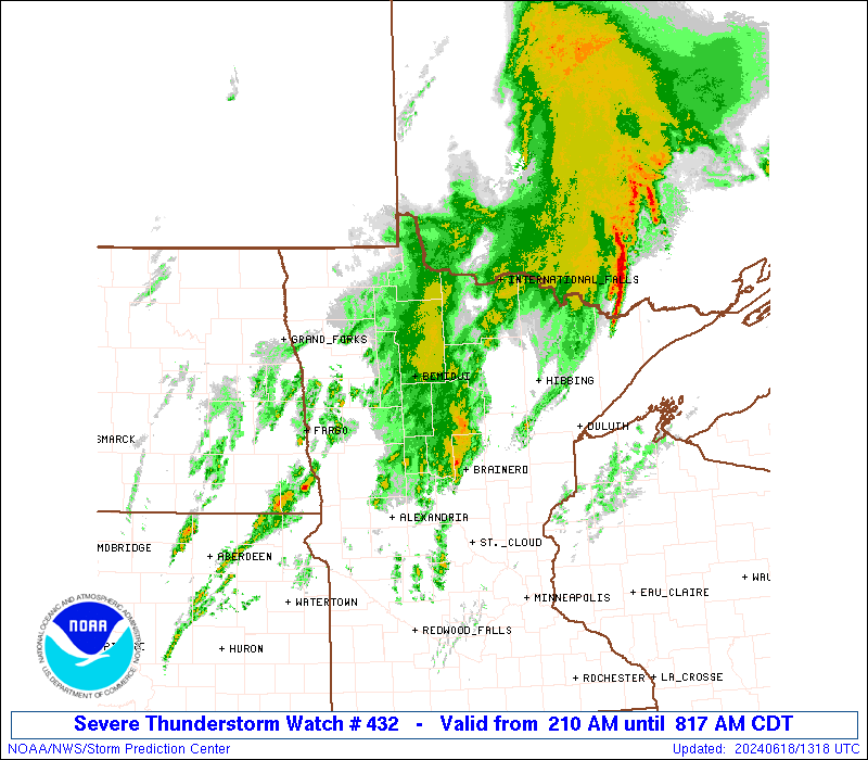
The severe thunderstorm watch area is approximately along and 70
statute miles north and south of a line from 55 miles northwest of
Detroit Lakes MN to 20 miles south southeast of Ely MN. For a
complete depiction of the watch see the associated watch outline
update (WOUS64 KWNS WOU2).
PRECAUTIONARY/PREPAREDNESS ACTIONS...
REMEMBER...A Severe Thunderstorm Watch means conditions are
favorable for severe thunderstorms in and close to the watch area.
Persons in these areas should be on the lookout for threatening
weather conditions and listen for later statements and possible
warnings. Severe thunderstorms can and occasionally do produce
tornadoes.
&&
OTHER WATCH INFORMATION...CONTINUE...WW 431...
AVIATION...A few severe thunderstorms with hail surface and aloft to
1 inch. Extreme turbulence and surface wind gusts to 60 knots. A few
cumulonimbi with maximum tops to 550. Mean storm motion vector
25035.
...Guyer

   SEL2

   URGENT - IMMEDIATE BROADCAST REQUESTED
   Severe Thunderstorm Watch Number 432
   NWS Storm Prediction Center Norman OK
   210 AM CDT Tue Jun 18 2024

   The NWS Storm Prediction Center has issued a

   * Severe Thunderstorm Watch for portions of
     Northern Minnesota

   * Effective this Tuesday morning from 210 AM until 900 AM CDT.

   * Primary threats include...
     Scattered damaging wind gusts to 70 mph possible
     Isolated large hail events to 1 inch in diameter possible

   SUMMARY...A line of convection will move east-northeastward across
   northern Minnesota overnight, with other strong to potentially
   severe storms preceding it, with locally damaging winds and some
   hail possible.

   The severe thunderstorm watch area is approximately along and 70
   statute miles north and south of a line from 55 miles northwest of
   Detroit Lakes MN to 20 miles south southeast of Ely MN. For a
   complete depiction of the watch see the associated watch outline
   update (WOUS64 KWNS WOU2).

   PRECAUTIONARY/PREPAREDNESS ACTIONS...

   REMEMBER...A Severe Thunderstorm Watch means conditions are
   favorable for severe thunderstorms in and close to the watch area.
   Persons in these areas should be on the lookout for threatening
   weather conditions and listen for later statements and possible
   warnings. Severe thunderstorms can and occasionally do produce
   tornadoes.

   &&

   OTHER WATCH INFORMATION...CONTINUE...WW 431...

   AVIATION...A few severe thunderstorms with hail surface and aloft to
   1 inch. Extreme turbulence and surface wind gusts to 60 knots. A few
   cumulonimbi with maximum tops to 550. Mean storm motion vector
   25035.

   ...Guyer
 Note:
The Aviation Watch (SAW) product is an approximation to the watch area.
The actual watch is depicted by the shaded areas.
Note:
The Aviation Watch (SAW) product is an approximation to the watch area.
The actual watch is depicted by the shaded areas.
   SAW2
   WW 432 SEVERE TSTM MN 180710Z - 181400Z
   AXIS..70 STATUTE MILES NORTH AND SOUTH OF LINE..
   55NW DTL/DETROIT LAKES MN/ - 20SSE ELO/ELY MN/
   ..AVIATION COORDS.. 60NM N/S /39SSE GFK - 54NNE DLH/
   HAIL SURFACE AND ALOFT..1 INCH. WIND GUSTS..60 KNOTS.
   MAX TOPS TO 550. MEAN STORM MOTION VECTOR 25035.

   LAT...LON 48409671 48659171 46629171 46389671

   THIS IS AN APPROXIMATION TO THE WATCH AREA.  FOR A
   COMPLETE DEPICTION OF THE WATCH SEE WOUS64 KWNS
   FOR WOU2.
Watch 432 Status Report Messages:
STATUS REPORT #5 ON WW 432

VALID 181220Z - 181340Z

SEVERE WEATHER THREAT CONTINUES RIGHT OF A LINE FROM 15 ENE BRD
TO HIB TO 40 ENE INL.

..LEITMAN..06/18/24

ATTN...WFO...DLH...FGF...

&&

STATUS REPORT FOR WS 432

SEVERE WEATHER THREAT CONTINUES FOR THE FOLLOWING AREAS

MNC001-017-137-181340-

MN
.    MINNESOTA COUNTIES INCLUDED ARE

AITKIN		     CARLTON		 ST. LOUIS
$$


THE WATCH STATUS MESSAGE IS FOR GUIDANCE PURPOSES ONLY.  PLEASE
REFER TO WATCH COUNTY NOTIFICATION STATEMENTS FOR OFFICIAL
INFORMATION ON COUNTIES...INDEPENDENT CITIES AND MARINE ZONES
CLEARED FROM SEVERE THUNDERSTORM AND TORNADO WATCHES.
$$

STATUS REPORT #4 ON WW 432

VALID 181135Z - 181240Z

SEVERE WEATHER THREAT CONTINUES RIGHT OF A LINE FROM 15 W BRD TO
50 WNW HIB TO 25 ENE INL.

..LEITMAN..06/18/24

ATTN...WFO...DLH...FGF...

&&

STATUS REPORT FOR WS 432

SEVERE WEATHER THREAT CONTINUES FOR THE FOLLOWING AREAS

MNC001-017-035-061-137-181240-

MN
.    MINNESOTA COUNTIES INCLUDED ARE

AITKIN		     CARLTON		 CROW WING
ITASCA		     ST. LOUIS
$$


THE WATCH STATUS MESSAGE IS FOR GUIDANCE PURPOSES ONLY.  PLEASE
REFER TO WATCH COUNTY NOTIFICATION STATEMENTS FOR OFFICIAL
INFORMATION ON COUNTIES...INDEPENDENT CITIES AND MARINE ZONES
CLEARED FROM SEVERE THUNDERSTORM AND TORNADO WATCHES.
$$

STATUS REPORT #3 ON WW 432

VALID 181035Z - 181140Z

SEVERE WEATHER THREAT CONTINUES RIGHT OF A LINE FROM 35 S DTL TO
15 SSW BJI TO 15 WNW INL.

..LEITMAN..06/18/24

ATTN...WFO...DLH...FGF...

&&

STATUS REPORT FOR WS 432

SEVERE WEATHER THREAT CONTINUES FOR THE FOLLOWING AREAS

MNC001-017-021-035-057-061-071-111-137-159-181140-

MN
.    MINNESOTA COUNTIES INCLUDED ARE

AITKIN		     CARLTON		 CASS
CROW WING	     HUBBARD		 ITASCA
KOOCHICHING	     OTTER TAIL 	 ST. LOUIS
WADENA
$$


THE WATCH STATUS MESSAGE IS FOR GUIDANCE PURPOSES ONLY.  PLEASE
REFER TO WATCH COUNTY NOTIFICATION STATEMENTS FOR OFFICIAL
INFORMATION ON COUNTIES...INDEPENDENT CITIES AND MARINE ZONES
CLEARED FROM SEVERE THUNDERSTORM AND TORNADO WATCHES.
$$

STATUS REPORT #2 ON WW 432

VALID 180935Z - 181040Z

SEVERE WEATHER THREAT CONTINUES RIGHT OF A LINE FROM 25 SSW FAR
TO 40 W BJI TO 35 ENE RRT.

..LEITMAN..06/18/24

ATTN...WFO...DLH...FGF...

&&

STATUS REPORT FOR WS 432

SEVERE WEATHER THREAT CONTINUES FOR THE FOLLOWING AREAS

MNC001-005-007-017-021-029-035-057-061-071-077-087-111-137-159-
167-181040-

MN
.    MINNESOTA COUNTIES INCLUDED ARE

AITKIN		     BECKER		 BELTRAMI
CARLTON 	     CASS		 CLEARWATER
CROW WING	     HUBBARD		 ITASCA
KOOCHICHING	     LAKE OF THE WOODS	 MAHNOMEN
OTTER TAIL	     ST. LOUIS		 WADENA
WILKIN
$$


THE WATCH STATUS MESSAGE IS FOR GUIDANCE PURPOSES ONLY.  PLEASE
REFER TO WATCH COUNTY NOTIFICATION STATEMENTS FOR OFFICIAL
INFORMATION ON COUNTIES...INDEPENDENT CITIES AND MARINE ZONES
CLEARED FROM SEVERE THUNDERSTORM AND TORNADO WATCHES.
$$

STATUS REPORT #1 ON WW 432

VALID 180845Z - 180940Z

SEVERE WEATHER THREAT CONTINUES RIGHT OF A LINE FROM 25 NNW FAR
TO 10 SE TVF TO 15 S ROX.

..LEITMAN..06/18/24

ATTN...WFO...DLH...FGF...

&&

STATUS REPORT FOR WS 432

SEVERE WEATHER THREAT CONTINUES FOR THE FOLLOWING AREAS

MNC001-005-007-017-021-027-029-035-057-061-071-077-087-107-111-
119-137-159-167-180940-

MN
.    MINNESOTA COUNTIES INCLUDED ARE

AITKIN		     BECKER		 BELTRAMI
CARLTON 	     CASS		 CLAY
CLEARWATER	     CROW WING		 HUBBARD
ITASCA		     KOOCHICHING	 LAKE OF THE WOODS
MAHNOMEN	     NORMAN		 OTTER TAIL
POLK		     ST. LOUIS		 WADENA
WILKIN
$$


THE WATCH STATUS MESSAGE IS FOR GUIDANCE PURPOSES ONLY.  PLEASE
REFER TO WATCH COUNTY NOTIFICATION STATEMENTS FOR OFFICIAL
INFORMATION ON COUNTIES...INDEPENDENT CITIES AND MARINE ZONES
CLEARED FROM SEVERE THUNDERSTORM AND TORNADO WATCHES.
$$
Note:
Click for Complete Product Text.
Tornadoes
Probability of 2 or more tornadoes
|
Low (10%)
|
Probability of 1 or more strong (EF2-EF5) tornadoes
|
Low (5%)
|
Wind
Probability of 10 or more severe wind events
|
Mod (50%)
|
Probability of 1 or more wind events > 65 knots
|
Low (10%)
|
Hail
Probability of 10 or more severe hail events
|
Low (20%)
|
Probability of 1 or more hailstones > 2 inches
|
Low (<5%)
|
Combined Severe Hail/Wind
Probability of 6 or more combined severe hail/wind events
|
High (70%)
|
For each watch, probabilities for particular events inside the watch
(listed above in each table) are determined by the issuing forecaster.
The "Low" category contains probability values ranging from less than 2%
to 20% (EF2-EF5 tornadoes), less than 5% to 20% (all other probabilities),
"Moderate" from 30% to 60%, and "High" from 70% to greater than 95%.
High values are bolded and lighter in color to provide awareness of
an increased threat for a particular event.


 @NWSSPC