Note:
The expiration time in the watch graphic is amended if the watch is
replaced, cancelled or extended.
Note:
Note:
The expiration time in the watch graphic is amended if the watch is
replaced, cancelled or extended.
Note: Click for
Watch Status Reports.
SEL5
URGENT - IMMEDIATE BROADCAST REQUESTED
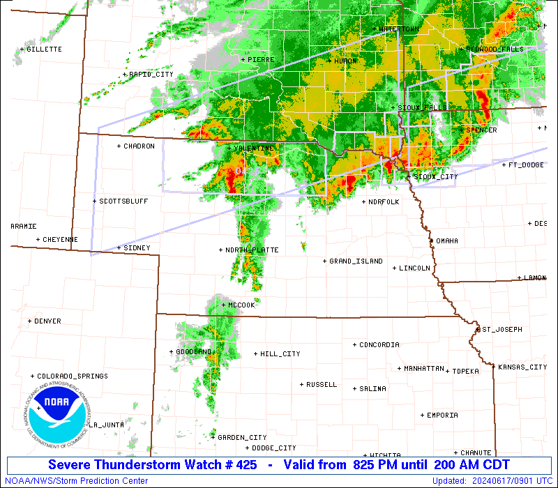
Severe Thunderstorm Watch Number 425
NWS Storm Prediction Center Norman OK
825 PM CDT Sun Jun 16 2024
The NWS Storm Prediction Center has issued a
* Severe Thunderstorm Watch for portions of
Southwest into Central and Northeast Nebraska
* Effective this Sunday night and Monday morning from 825 PM
until 200 AM CDT.
* Primary threats include...
Scattered large hail likely with isolated very large hail events
to 3 inches in diameter possible
Isolated damaging wind gusts to 70 mph possible
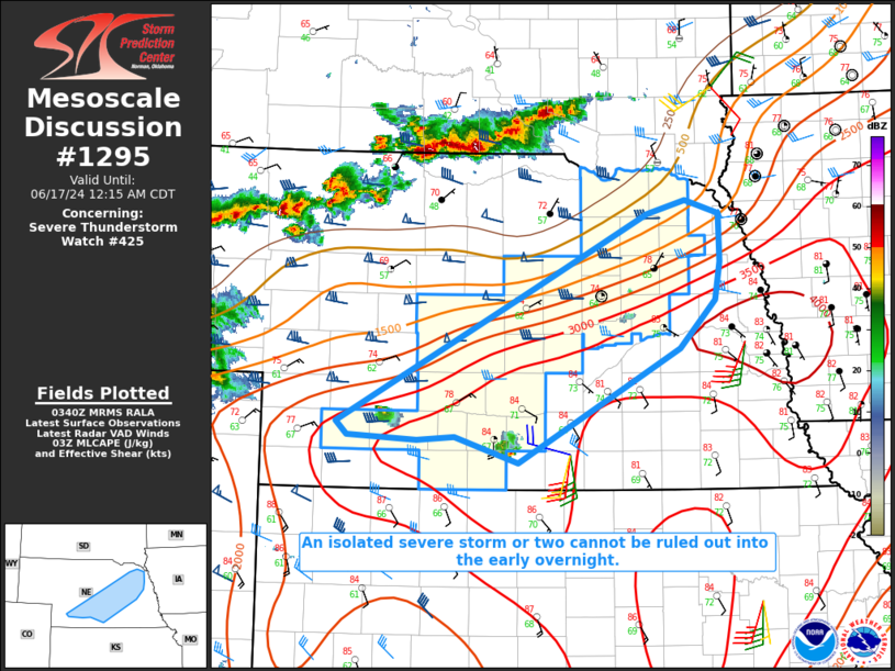
SUMMARY...Isolated to possibly widely scattered thunderstorms are
forecast to develop this evening into tonight along a frontal zone
extending from southwest Nebraska northeastward into northeast
Nebraska. The environment will support large to very large hail (1
to 3 inches in diameter) with any thunderstorm that is sustained and
intense. Isolated severe gusts (60-70 mph) may also accompany the
stronger thunderstorm cores.
The severe thunderstorm watch area is approximately along and 45
statute miles north and south of a line from 25 miles west northwest
of Mccook NE to 30 miles northeast of Norfolk NE. For a complete
depiction of the watch see the associated watch outline update
(WOUS64 KWNS WOU5).
PRECAUTIONARY/PREPAREDNESS ACTIONS...
REMEMBER...A Severe Thunderstorm Watch means conditions are
favorable for severe thunderstorms in and close to the watch area.
Persons in these areas should be on the lookout for threatening
weather conditions and listen for later statements and possible
warnings. Severe thunderstorms can and occasionally do produce
tornadoes.
&&
AVIATION...A few severe thunderstorms with hail surface and aloft to
3 inches. Extreme turbulence and surface wind gusts to 60 knots. A
few cumulonimbi with maximum tops to 550. Mean storm motion vector
26015.
...Smith
 Note:
The Aviation Watch (SAW) product is an approximation to the watch area.
The actual watch is depicted by the shaded areas.
Note:
The Aviation Watch (SAW) product is an approximation to the watch area.
The actual watch is depicted by the shaded areas.
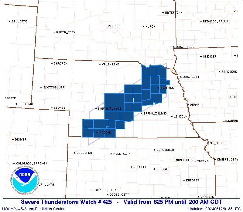
   SAW5
   WW 425 SEVERE TSTM NE 170125Z - 170700Z
   AXIS..45 STATUTE MILES NORTH AND SOUTH OF LINE..
   25WNW MCK/MCCOOK NE/ - 30NE OFK/NORFOLK NE/
   ..AVIATION COORDS.. 40NM N/S /21WNW MCK - 75E ONL/
   HAIL SURFACE AND ALOFT..3 INCHES. WIND GUSTS..60 KNOTS.
   MAX TOPS TO 550. MEAN STORM MOTION VECTOR 26015.

   LAT...LON 40990102 42949702 41639702 39680102

   THIS IS AN APPROXIMATION TO THE WATCH AREA.  FOR A
   COMPLETE DEPICTION OF THE WATCH SEE WOUS64 KWNS
   FOR WOU5.
Watch 425 Status Report Messages:
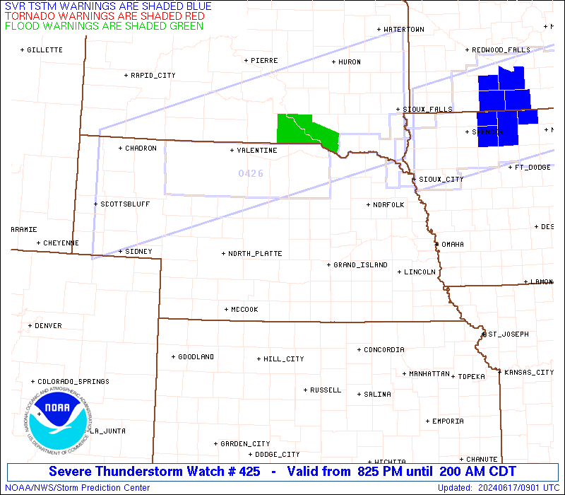
STATUS REPORT #3 ON WW 425

VALID 170455Z - 170540Z

SEVERE WEATHER THREAT CONTINUES RIGHT OF A LINE FROM 25 SW SUX TO
20 ESE IML.

FOR ADDITIONAL INFORMATION SEE MESOSCALE DISCUSSION 1295

..DEAN..06/17/24

ATTN...WFO...OAX...GID...LBF...GLD...

&&

STATUS REPORT FOR WS 425

SEVERE WEATHER THREAT CONTINUES FOR THE FOLLOWING AREAS

NEC027-107-170540-

NE
.    NEBRASKA COUNTIES INCLUDED ARE

CEDAR		     KNOX
$$


THE WATCH STATUS MESSAGE IS FOR GUIDANCE PURPOSES ONLY.  PLEASE
REFER TO WATCH COUNTY NOTIFICATION STATEMENTS FOR OFFICIAL
INFORMATION ON COUNTIES...INDEPENDENT CITIES AND MARINE ZONES
CLEARED FROM SEVERE THUNDERSTORM AND TORNADO WATCHES.
$$

STATUS REPORT #2 ON WW 425

VALID 170320Z - 170440Z

THE SEVERE WEATHER THREAT CONTINUES ACROSS THE ENTIRE WATCH AREA.

..DEAN..06/17/24

ATTN...WFO...OAX...GID...LBF...GLD...

&&

STATUS REPORT FOR WS 425

SEVERE WEATHER THREAT CONTINUES FOR THE FOLLOWING AREAS

NEC003-011-019-027-041-047-063-065-071-073-077-083-085-087-093-
099-107-119-125-137-139-141-145-163-167-175-179-183-170440-

NE
.    NEBRASKA COUNTIES INCLUDED ARE

ANTELOPE	     BOONE		 BUFFALO
CEDAR		     CUSTER		 DAWSON
FRONTIER	     FURNAS		 GARFIELD
GOSPER		     GREELEY		 HARLAN
HAYES		     HITCHCOCK		 HOWARD
KEARNEY 	     KNOX		 MADISON
NANCE		     PHELPS		 PIERCE
PLATTE		     RED WILLOW 	 SHERMAN
STANTON 	     VALLEY		 WAYNE
WHEELER
$$


THE WATCH STATUS MESSAGE IS FOR GUIDANCE PURPOSES ONLY.  PLEASE
REFER TO WATCH COUNTY NOTIFICATION STATEMENTS FOR OFFICIAL
INFORMATION ON COUNTIES...INDEPENDENT CITIES AND MARINE ZONES
CLEARED FROM SEVERE THUNDERSTORM AND TORNADO WATCHES.
$$

STATUS REPORT #1 ON WW 425

VALID 170220Z - 170340Z

THE SEVERE WEATHER THREAT CONTINUES ACROSS THE ENTIRE WATCH AREA.

..DEAN..06/17/24

ATTN...WFO...OAX...GID...LBF...GLD...

&&

STATUS REPORT FOR WS 425

SEVERE WEATHER THREAT CONTINUES FOR THE FOLLOWING AREAS

NEC003-011-019-027-041-047-063-065-071-073-077-085-087-093-107-
119-125-137-139-141-145-163-167-175-179-183-170340-

NE
.    NEBRASKA COUNTIES INCLUDED ARE

ANTELOPE	     BOONE		 BUFFALO
CEDAR		     CUSTER		 DAWSON
FRONTIER	     FURNAS		 GARFIELD
GOSPER		     GREELEY		 HAYES
HITCHCOCK	     HOWARD		 KNOX
MADISON 	     NANCE		 PHELPS
PIERCE		     PLATTE		 RED WILLOW
SHERMAN 	     STANTON		 VALLEY
WAYNE		     WHEELER
$$


THE WATCH STATUS MESSAGE IS FOR GUIDANCE PURPOSES ONLY.  PLEASE
REFER TO WATCH COUNTY NOTIFICATION STATEMENTS FOR OFFICIAL
INFORMATION ON COUNTIES...INDEPENDENT CITIES AND MARINE ZONES
CLEARED FROM SEVERE THUNDERSTORM AND TORNADO WATCHES.
$$
Note:
Click for Complete Product Text.
Tornadoes
Probability of 2 or more tornadoes
|
Low (10%)
|
Probability of 1 or more strong (EF2-EF5) tornadoes
|
Low (5%)
|
Wind
Probability of 10 or more severe wind events
|
Low (20%)
|
Probability of 1 or more wind events > 65 knots
|
Low (20%)
|
Hail
Probability of 10 or more severe hail events
|
Mod (60%)
|
Probability of 1 or more hailstones > 2 inches
|
Mod (30%)
|
Combined Severe Hail/Wind
Probability of 6 or more combined severe hail/wind events
|
High (80%)
|
For each watch, probabilities for particular events inside the watch
(listed above in each table) are determined by the issuing forecaster.
The "Low" category contains probability values ranging from less than 2%
to 20% (EF2-EF5 tornadoes), less than 5% to 20% (all other probabilities),
"Moderate" from 30% to 60%, and "High" from 70% to greater than 95%.
High values are bolded and lighter in color to provide awareness of
an increased threat for a particular event.


 @NWSSPC