 Note:
The expiration time in the watch graphic is amended if the watch is
replaced, cancelled or extended.
Note:
Note:
The expiration time in the watch graphic is amended if the watch is
replaced, cancelled or extended.
Note: Click for
Watch Status Reports.
SEL2
URGENT - IMMEDIATE BROADCAST REQUESTED
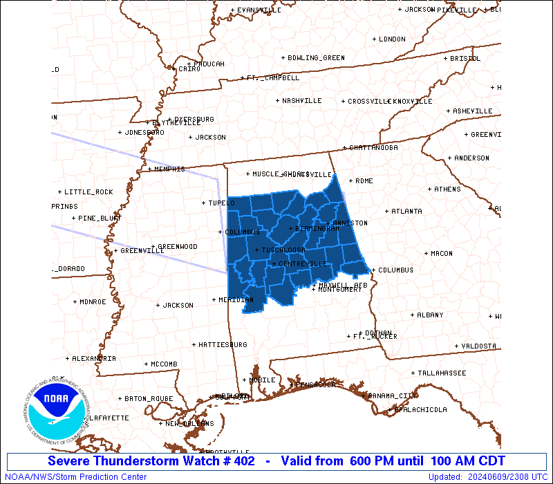
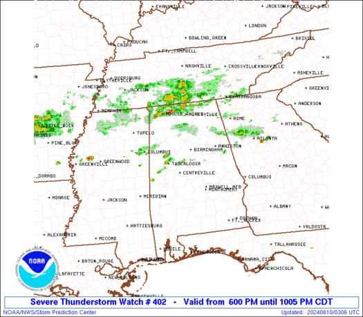
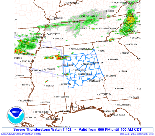
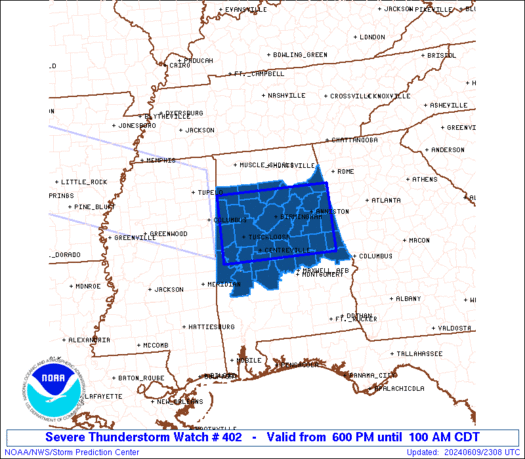
Severe Thunderstorm Watch Number 402
NWS Storm Prediction Center Norman OK
600 PM CDT Sun Jun 9 2024
The NWS Storm Prediction Center has issued a
* Severe Thunderstorm Watch for portions of
Central and Northern Alabama
* Effective this Sunday night and Monday morning from 600 PM
until 100 AM CDT.
* Primary threats include...
Scattered large hail and isolated very large hail events to 2
inches in diameter possible
Scattered damaging wind gusts to 70 mph possible
SUMMARY...Scattered severe thunderstorms are expected to develop and
move east across the watch area this evening and tonight, with a
risk for damaging wind gusts and large hail.
The severe thunderstorm watch area is approximately along and 50
statute miles north and south of a line from 35 miles west northwest
of Tuscaloosa AL to 30 miles east southeast of Anniston AL. For a
complete depiction of the watch see the associated watch outline
update (WOUS64 KWNS WOU2).
PRECAUTIONARY/PREPAREDNESS ACTIONS...
REMEMBER...A Severe Thunderstorm Watch means conditions are
favorable for severe thunderstorms in and close to the watch area.
Persons in these areas should be on the lookout for threatening
weather conditions and listen for later statements and possible
warnings. Severe thunderstorms can and occasionally do produce
tornadoes.
&&
OTHER WATCH INFORMATION...CONTINUE...WW 401...
AVIATION...A few severe thunderstorms with hail surface and aloft to
2 inches. Extreme turbulence and surface wind gusts to 60 knots. A
few cumulonimbi with maximum tops to 550. Mean storm motion vector
27025.
...Bunting
   SEL2

   URGENT - IMMEDIATE BROADCAST REQUESTED
   Severe Thunderstorm Watch Number 402
   NWS Storm Prediction Center Norman OK
   600 PM CDT Sun Jun 9 2024

   The NWS Storm Prediction Center has issued a

   * Severe Thunderstorm Watch for portions of
     Central and Northern Alabama

   * Effective this Sunday night and Monday morning from 600 PM
     until 100 AM CDT.

   * Primary threats include...
     Scattered large hail and isolated very large hail events to 2
       inches in diameter possible
     Scattered damaging wind gusts to 70 mph possible

   SUMMARY...Scattered severe thunderstorms are expected to develop and
   move east across the watch area this evening and tonight, with a
   risk for damaging wind gusts and large hail.

   The severe thunderstorm watch area is approximately along and 50
   statute miles north and south of a line from 35 miles west northwest
   of Tuscaloosa AL to 30 miles east southeast of Anniston AL. For a
   complete depiction of the watch see the associated watch outline
   update (WOUS64 KWNS WOU2).

   PRECAUTIONARY/PREPAREDNESS ACTIONS...

   REMEMBER...A Severe Thunderstorm Watch means conditions are
   favorable for severe thunderstorms in and close to the watch area.
   Persons in these areas should be on the lookout for threatening
   weather conditions and listen for later statements and possible
   warnings. Severe thunderstorms can and occasionally do produce
   tornadoes.

   &&

   OTHER WATCH INFORMATION...CONTINUE...WW 401...

   AVIATION...A few severe thunderstorms with hail surface and aloft to
   2 inches. Extreme turbulence and surface wind gusts to 60 knots. A
   few cumulonimbi with maximum tops to 550. Mean storm motion vector
   27025.

   ...Bunting
 Note:
The Aviation Watch (SAW) product is an approximation to the watch area.
The actual watch is depicted by the shaded areas.
Note:
The Aviation Watch (SAW) product is an approximation to the watch area.
The actual watch is depicted by the shaded areas.
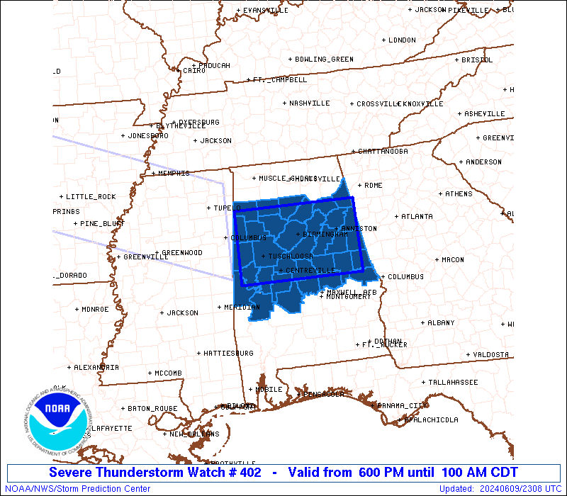
   SAW2
   WW 402 SEVERE TSTM AL 092300Z - 100600Z
   AXIS..50 STATUTE MILES NORTH AND SOUTH OF LINE..
   35WNW TCL/TUSCALOOSA AL/ - 30ESE ANB/ANNISTON AL/
   ..AVIATION COORDS.. 45NM N/S /17ESE IGB - 23NNW LGC/
   HAIL SURFACE AND ALOFT..2 INCHES. WIND GUSTS..60 KNOTS.
   MAX TOPS TO 550. MEAN STORM MOTION VECTOR 27025.

   LAT...LON 34148818 34148537 32688537 32688818

   THIS IS AN APPROXIMATION TO THE WATCH AREA.  FOR A
   COMPLETE DEPICTION OF THE WATCH SEE WOUS64 KWNS
   FOR WOU2.
Watch 402 Status Report Messages:
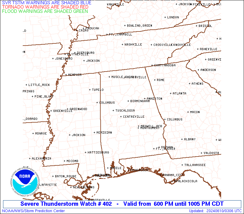
STATUS REPORT #2 ON WW 402
VALID 100230Z - 100340Z
THE SEVERE WEATHER THREAT CONTINUES ACROSS THE ENTIRE WATCH AREA.
..DEAN..06/10/24
ATTN...WFO...BMX...HUN...
&&
STATUS REPORT FOR WS 402
SEVERE WEATHER THREAT CONTINUES FOR THE FOLLOWING AREAS
ALC001-007-009-015-017-019-021-027-029-037-047-051-055-057-063-
065-073-075-081-091-093-105-107-111-115-117-119-121-123-125-127-
133-100340-
AL
. ALABAMA COUNTIES INCLUDED ARE
AUTAUGA BIBB BLOUNT
CALHOUN CHAMBERS CHEROKEE
CHILTON CLAY CLEBURNE
COOSA DALLAS ELMORE
ETOWAH FAYETTE GREENE
HALE JEFFERSON LAMAR
LEE MARENGO MARION
PERRY PICKENS RANDOLPH
ST. CLAIR SHELBY SUMTER
TALLADEGA TALLAPOOSA TUSCALOOSA
WALKER WINSTON
$$
THE WATCH STATUS MESSAGE IS FOR GUIDANCE PURPOSES ONLY. PLEASE
REFER TO WATCH COUNTY NOTIFICATION STATEMENTS FOR OFFICIAL
INFORMATION ON COUNTIES...INDEPENDENT CITIES AND MARINE ZONES
CLEARED FROM SEVERE THUNDERSTORM AND TORNADO WATCHES.
$$
STATUS REPORT #1 ON WW 402
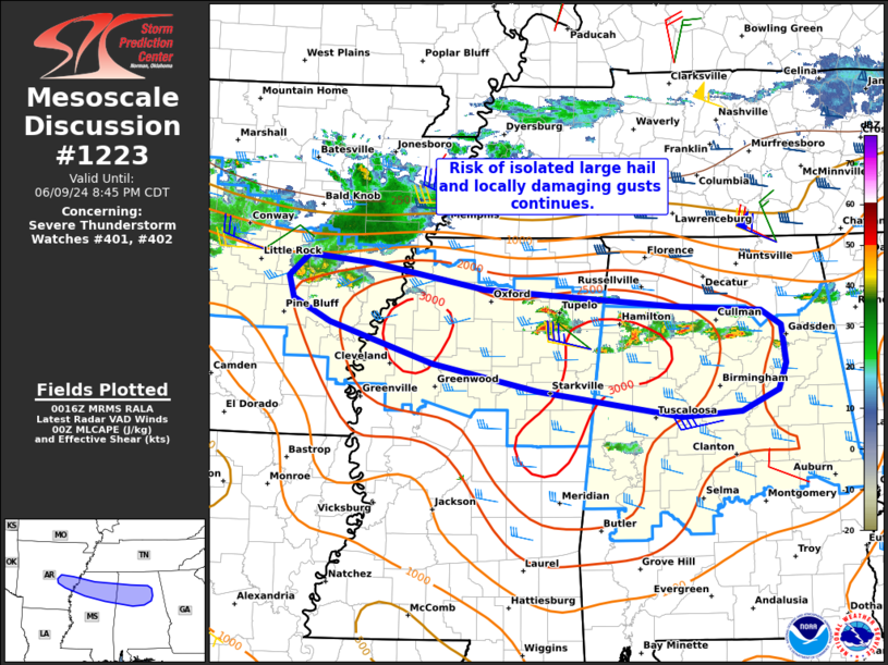
VALID 100140Z - 100240Z
THE SEVERE WEATHER THREAT CONTINUES ACROSS THE ENTIRE WATCH AREA.
FOR ADDITIONAL INFORMATION SEE MESOSCALE DISCUSSION 1223
..WEINMAN..06/10/24
ATTN...WFO...BMX...HUN...
&&
STATUS REPORT FOR WS 402
SEVERE WEATHER THREAT CONTINUES FOR THE FOLLOWING AREAS
ALC001-007-009-015-017-019-021-027-029-037-043-047-051-055-057-
063-065-073-075-081-091-093-105-107-111-115-117-119-121-123-125-
127-133-100240-
AL
. ALABAMA COUNTIES INCLUDED ARE
AUTAUGA BIBB BLOUNT
CALHOUN CHAMBERS CHEROKEE
CHILTON CLAY CLEBURNE
COOSA CULLMAN DALLAS
ELMORE ETOWAH FAYETTE
GREENE HALE JEFFERSON
LAMAR LEE MARENGO
MARION PERRY PICKENS
RANDOLPH ST. CLAIR SHELBY
SUMTER TALLADEGA TALLAPOOSA
TUSCALOOSA WALKER WINSTON
$$
THE WATCH STATUS MESSAGE IS FOR GUIDANCE PURPOSES ONLY. PLEASE
REFER TO WATCH COUNTY NOTIFICATION STATEMENTS FOR OFFICIAL
INFORMATION ON COUNTIES...INDEPENDENT CITIES AND MARINE ZONES
CLEARED FROM SEVERE THUNDERSTORM AND TORNADO WATCHES.
$$
Note:
Click for Complete Product Text.
Tornadoes
Probability of 2 or more tornadoes
|
Low (10%)
|
Probability of 1 or more strong (EF2-EF5) tornadoes
|
Low (<2%)
|
Wind
Probability of 10 or more severe wind events
|
Mod (40%)
|
Probability of 1 or more wind events > 65 knots
|
Low (20%)
|
Hail
Probability of 10 or more severe hail events
|
Mod (40%)
|
Probability of 1 or more hailstones > 2 inches
|
Mod (30%)
|
Combined Severe Hail/Wind
Probability of 6 or more combined severe hail/wind events
|
High (70%)
|
For each watch, probabilities for particular events inside the watch
(listed above in each table) are determined by the issuing forecaster.
The "Low" category contains probability values ranging from less than 2%
to 20% (EF2-EF5 tornadoes), less than 5% to 20% (all other probabilities),
"Moderate" from 30% to 60%, and "High" from 70% to greater than 95%.
High values are bolded and lighter in color to provide awareness of
an increased threat for a particular event.


 @NWSSPC