Note:
The expiration time in the watch graphic is amended if the watch is
replaced, cancelled or extended.
Note:
Note:
The expiration time in the watch graphic is amended if the watch is
replaced, cancelled or extended.
Note: Click for
Watch Status Reports.
SEL0
URGENT - IMMEDIATE BROADCAST REQUESTED
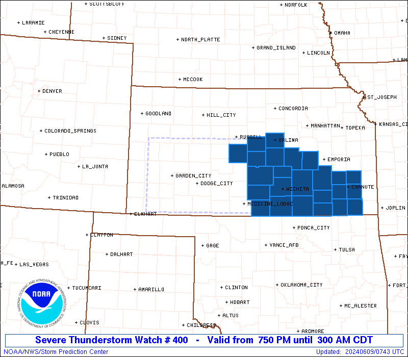
Severe Thunderstorm Watch Number 400
NWS Storm Prediction Center Norman OK
750 PM CDT Sat Jun 8 2024
The NWS Storm Prediction Center has issued a
* Severe Thunderstorm Watch for portions of
Western and Central Kansas
* Effective this Saturday night and Sunday morning from 750 PM
until 300 AM CDT.
* Primary threats include...
Scattered damaging winds and isolated significant gusts to 80
mph likely
Scattered large hail and isolated very large hail events to 2.5
inches in diameter possible
A tornado or two possible
SUMMARY...Severe thunderstorms will move east across the watch area
this evening and overnight, with a risk for significant damaging
wind gusts up to 80 mph and very large hail. A tornado or two will
also be possible.
The severe thunderstorm watch area is approximately along and 60
statute miles either side of a line from 40 miles west of Garden
City KS to 20 miles north of Wichita KS. For a complete depiction of
the watch see the associated watch outline update (WOUS64 KWNS
WOU0).
PRECAUTIONARY/PREPAREDNESS ACTIONS...
REMEMBER...A Severe Thunderstorm Watch means conditions are
favorable for severe thunderstorms in and close to the watch area.
Persons in these areas should be on the lookout for threatening
weather conditions and listen for later statements and possible
warnings. Severe thunderstorms can and occasionally do produce
tornadoes.
&&
OTHER WATCH INFORMATION...CONTINUE...WW 398...WW 399...
AVIATION...A few severe thunderstorms with hail surface and aloft to
2.5 inches. Extreme turbulence and surface wind gusts to 70 knots. A
few cumulonimbi with maximum tops to 550. Mean storm motion vector
29035.
...Bunting

   SEL0

   URGENT - IMMEDIATE BROADCAST REQUESTED
   Severe Thunderstorm Watch Number 400
   NWS Storm Prediction Center Norman OK
   750 PM CDT Sat Jun 8 2024

   The NWS Storm Prediction Center has issued a

   * Severe Thunderstorm Watch for portions of
     Western and Central Kansas

   * Effective this Saturday night and Sunday morning from 750 PM
     until 300 AM CDT.

   * Primary threats include...
     Scattered damaging winds and isolated significant gusts to 80
       mph likely
     Scattered large hail and isolated very large hail events to 2.5
       inches in diameter possible
     A tornado or two possible

   SUMMARY...Severe thunderstorms will move east across the watch area
   this evening and overnight, with a risk for significant damaging
   wind gusts up to 80 mph and very large hail.  A tornado or two will
   also be possible.

   The severe thunderstorm watch area is approximately along and 60
   statute miles either side of a line from 40 miles west of Garden
   City KS to 20 miles north of Wichita KS. For a complete depiction of
   the watch see the associated watch outline update (WOUS64 KWNS
   WOU0).

   PRECAUTIONARY/PREPAREDNESS ACTIONS...

   REMEMBER...A Severe Thunderstorm Watch means conditions are
   favorable for severe thunderstorms in and close to the watch area.
   Persons in these areas should be on the lookout for threatening
   weather conditions and listen for later statements and possible
   warnings. Severe thunderstorms can and occasionally do produce
   tornadoes.

   &&

   OTHER WATCH INFORMATION...CONTINUE...WW 398...WW 399...

   AVIATION...A few severe thunderstorms with hail surface and aloft to
   2.5 inches. Extreme turbulence and surface wind gusts to 70 knots. A
   few cumulonimbi with maximum tops to 550. Mean storm motion vector
   29035.

   ...Bunting
 Note:
The Aviation Watch (SAW) product is an approximation to the watch area.
The actual watch is depicted by the shaded areas.
Note:
The Aviation Watch (SAW) product is an approximation to the watch area.
The actual watch is depicted by the shaded areas.
SAW0
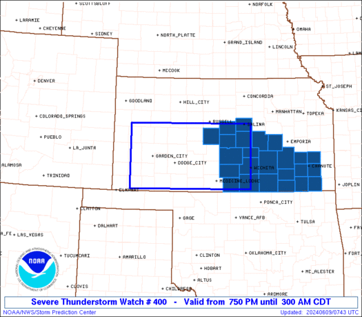
WW 400 SEVERE TSTM KS 090050Z - 090800Z
AXIS..60 STATUTE MILES EITHER SIDE OF LINE..
40W GCK/GARDEN CITY KS/ - 20N ICT/WICHITA KS/
..AVIATION COORDS.. 50NM EITHER SIDE /34W GCK - 13NNE ICT/
HAIL SURFACE AND ALOFT..2.5 INCHES. WIND GUSTS..70 KNOTS.
MAX TOPS TO 550. MEAN STORM MOTION VECTOR 29035.
LAT...LON 38800147 38819744 37079742 37060144
THIS IS AN APPROXIMATION TO THE WATCH AREA. FOR A
COMPLETE DEPICTION OF THE WATCH SEE WOUS64 KWNS
FOR WOU0.
Watch 400 Status Report Messages:
STATUS REPORT #4 ON WW 400

VALID 090740Z - 090840Z

SEVERE WEATHER THREAT CONTINUES RIGHT OF A LINE FROM 25 WNW PNC
TO 15 S HUT TO 30 WNW HUT TO 25 ENE RSL.

..BENTLEY..06/09/24

ATTN...WFO...DDC...ICT...GLD...

&&

STATUS REPORT FOR WS 400

SEVERE WEATHER THREAT CONTINUES FOR THE FOLLOWING AREAS

KSC001-015-017-019-035-049-053-073-079-099-113-115-125-133-155-
159-169-173-191-205-207-090840-

KS
.    KANSAS COUNTIES INCLUDED ARE

ALLEN		     BUTLER		 CHASE
CHAUTAUQUA	     COWLEY		 ELK
ELLSWORTH	     GREENWOOD		 HARVEY
LABETTE 	     MCPHERSON		 MARION
MONTGOMERY	     NEOSHO		 RENO
RICE		     SALINE		 SEDGWICK
SUMNER		     WILSON		 WOODSON
$$


THE WATCH STATUS MESSAGE IS FOR GUIDANCE PURPOSES ONLY.  PLEASE
REFER TO WATCH COUNTY NOTIFICATION STATEMENTS FOR OFFICIAL
INFORMATION ON COUNTIES...INDEPENDENT CITIES AND MARINE ZONES
CLEARED FROM SEVERE THUNDERSTORM AND TORNADO WATCHES.
$$

STATUS REPORT #3 ON WW 400

VALID 090455Z - 090540Z

SEVERE WEATHER THREAT CONTINUES RIGHT OF A LINE FROM 10 E LBL TO
40 W RSL.

..SPC..06/09/24

ATTN...WFO...DDC...ICT...GLD...

&&

STATUS REPORT FOR WS 400

SEVERE WEATHER THREAT CONTINUES FOR THE FOLLOWING AREAS

KSC007-009-025-033-047-053-057-069-077-079-083-095-097-105-113-
119-135-145-151-155-159-165-167-169-173-175-185-191-090540-

KS
.    KANSAS COUNTIES INCLUDED ARE

BARBER		     BARTON		 CLARK
COMANCHE	     EDWARDS		 ELLSWORTH
FORD		     GRAY		 HARPER
HARVEY		     HODGEMAN		 KINGMAN
KIOWA		     LINCOLN		 MCPHERSON
MEADE		     NESS		 PAWNEE
PRATT		     RENO		 RICE
RUSH		     RUSSELL		 SALINE
SEDGWICK	     SEWARD		 STAFFORD
SUMNER
$$


THE WATCH STATUS MESSAGE IS FOR GUIDANCE PURPOSES ONLY.  PLEASE
REFER TO WATCH COUNTY NOTIFICATION STATEMENTS FOR OFFICIAL
INFORMATION ON COUNTIES...INDEPENDENT CITIES AND MARINE ZONES
CLEARED FROM SEVERE THUNDERSTORM AND TORNADO WATCHES.
$$

STATUS REPORT #2 ON WW 400

VALID 090335Z - 090440Z

SEVERE WEATHER THREAT CONTINUES RIGHT OF A LINE FROM 40 WSW GCK
TO 60 N GCK.

..SPC..06/09/24

ATTN...WFO...DDC...ICT...GLD...

&&

STATUS REPORT FOR WS 400

SEVERE WEATHER THREAT CONTINUES FOR THE FOLLOWING AREAS

KSC007-009-025-033-047-051-053-055-057-067-069-077-079-081-083-
093-095-097-101-105-113-119-135-145-151-155-159-165-167-169-171-
173-175-185-189-191-195-090440-

KS
.    KANSAS COUNTIES INCLUDED ARE

BARBER		     BARTON		 CLARK
COMANCHE	     EDWARDS		 ELLIS
ELLSWORTH	     FINNEY		 FORD
GRANT		     GRAY		 HARPER
HARVEY		     HASKELL		 HODGEMAN
KEARNY		     KINGMAN		 KIOWA
LANE		     LINCOLN		 MCPHERSON
MEADE		     NESS		 PAWNEE
PRATT		     RENO		 RICE
RUSH		     RUSSELL		 SALINE
SCOTT		     SEDGWICK		 SEWARD
STAFFORD	     STEVENS		 SUMNER
TREGO
$$


THE WATCH STATUS MESSAGE IS FOR GUIDANCE PURPOSES ONLY.  PLEASE
REFER TO WATCH COUNTY NOTIFICATION STATEMENTS FOR OFFICIAL
INFORMATION ON COUNTIES...INDEPENDENT CITIES AND MARINE ZONES
CLEARED FROM SEVERE THUNDERSTORM AND TORNADO WATCHES.
$$

STATUS REPORT #1 ON WW 400

VALID 090140Z - 090240Z

THE SEVERE WEATHER THREAT CONTINUES ACROSS THE ENTIRE WATCH AREA.

FOR ADDITIONAL INFORMATION SEE MESOSCALE DISCUSSION 1209

..WEINMAN..06/09/24

ATTN...WFO...DDC...ICT...GLD...

&&

STATUS REPORT FOR WS 400

SEVERE WEATHER THREAT CONTINUES FOR THE FOLLOWING AREAS

KSC007-009-025-033-047-051-053-055-057-063-067-069-075-077-079-
081-083-093-095-097-101-105-113-119-129-135-145-151-155-159-165-
167-169-171-173-175-179-185-187-189-191-195-090240-

KS
.    KANSAS COUNTIES INCLUDED ARE

BARBER		     BARTON		 CLARK
COMANCHE	     EDWARDS		 ELLIS
ELLSWORTH	     FINNEY		 FORD
GOVE		     GRANT		 GRAY
HAMILTON	     HARPER		 HARVEY
HASKELL 	     HODGEMAN		 KEARNY
KINGMAN 	     KIOWA		 LANE
LINCOLN 	     MCPHERSON		 MEADE
MORTON		     NESS		 PAWNEE
PRATT		     RENO		 RICE
RUSH		     RUSSELL		 SALINE
SCOTT		     SEDGWICK		 SEWARD
SHERIDAN	     STAFFORD		 STANTON
STEVENS 	     SUMNER		 TREGO
$$


THE WATCH STATUS MESSAGE IS FOR GUIDANCE PURPOSES ONLY.  PLEASE
REFER TO WATCH COUNTY NOTIFICATION STATEMENTS FOR OFFICIAL
INFORMATION ON COUNTIES...INDEPENDENT CITIES AND MARINE ZONES
CLEARED FROM SEVERE THUNDERSTORM AND TORNADO WATCHES.
$$
Note:
Click for Complete Product Text.
Tornadoes
Probability of 2 or more tornadoes
|
Low (20%)
|
Probability of 1 or more strong (EF2-EF5) tornadoes
|
Low (<2%)
|
Wind
Probability of 10 or more severe wind events
|
Mod (60%)
|
Probability of 1 or more wind events > 65 knots
|
Mod (60%)
|
Hail
Probability of 10 or more severe hail events
|
Mod (40%)
|
Probability of 1 or more hailstones > 2 inches
|
Mod (30%)
|
Combined Severe Hail/Wind
Probability of 6 or more combined severe hail/wind events
|
High (90%)
|
For each watch, probabilities for particular events inside the watch
(listed above in each table) are determined by the issuing forecaster.
The "Low" category contains probability values ranging from less than 2%
to 20% (EF2-EF5 tornadoes), less than 5% to 20% (all other probabilities),
"Moderate" from 30% to 60%, and "High" from 70% to greater than 95%.
High values are bolded and lighter in color to provide awareness of
an increased threat for a particular event.


 @NWSSPC