Note:
The expiration time in the watch graphic is amended if the watch is
replaced, cancelled or extended.
Note:
Note:
The expiration time in the watch graphic is amended if the watch is
replaced, cancelled or extended.
Note: Click for
Watch Status Reports.
SEL4
URGENT - IMMEDIATE BROADCAST REQUESTED
Severe Thunderstorm Watch Number 384
NWS Storm Prediction Center Norman OK
500 AM CDT Mon Jun 3 2024
The NWS Storm Prediction Center has issued a
* Severe Thunderstorm Watch for portions of
South central Kansas
Northern and central Oklahoma
* Effective this Monday morning from 500 AM until NOON CDT.
* Primary threats include...
Scattered damaging winds likely with isolated significant gusts
to 80 mph possible
Isolated large hail events to 1.5 inches in diameter possible
SUMMARY...A well-developed MCS with embedded bowing segments will
continue east-southeastward through the morning from southwest
Kansas into south central Kansas and northern/central Oklahoma.
Damaging winds of 65-80 mph will be the main threat, while the
stronger embedded storms could produce isolated large hail of 1-1.5
inches in diameter.
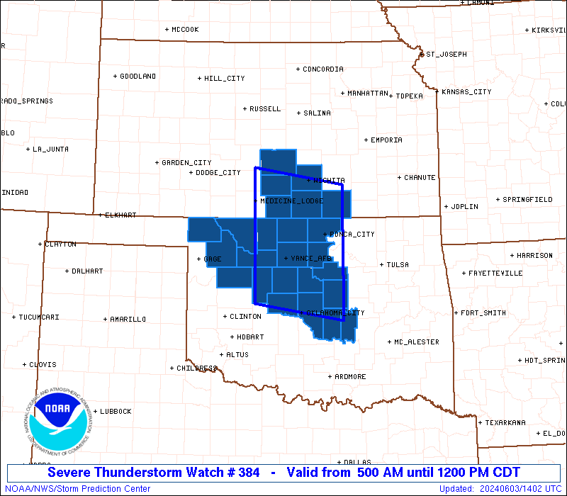
The severe thunderstorm watch area is approximately along and 80
statute miles north and south of a line from 40 miles south of
Medicine Lodge KS to 30 miles southeast of Ponca City OK. For a
complete depiction of the watch see the associated watch outline
update (WOUS64 KWNS WOU4).
PRECAUTIONARY/PREPAREDNESS ACTIONS...
REMEMBER...A Severe Thunderstorm Watch means conditions are
favorable for severe thunderstorms in and close to the watch area.
Persons in these areas should be on the lookout for threatening
weather conditions and listen for later statements and possible
warnings. Severe thunderstorms can and occasionally do produce
tornadoes.
&&
OTHER WATCH INFORMATION...CONTINUE...WW 383...
AVIATION...A few severe thunderstorms with hail surface and aloft to
1.5 inches. Extreme turbulence and surface wind gusts to 70 knots. A
few cumulonimbi with maximum tops to 550. Mean storm motion vector
31035.
...Thompson

   SEL4

   URGENT - IMMEDIATE BROADCAST REQUESTED
   Severe Thunderstorm Watch Number 384
   NWS Storm Prediction Center Norman OK
   500 AM CDT Mon Jun 3 2024

   The NWS Storm Prediction Center has issued a

   * Severe Thunderstorm Watch for portions of
     South central Kansas
     Northern and central Oklahoma

   * Effective this Monday morning from 500 AM until NOON CDT.

   * Primary threats include...
     Scattered damaging winds likely with isolated significant gusts
       to 80 mph possible
     Isolated large hail events to 1.5 inches in diameter possible

   SUMMARY...A well-developed MCS with embedded bowing segments will
   continue east-southeastward through the morning from southwest
   Kansas into south central Kansas and northern/central Oklahoma.
   Damaging winds of 65-80 mph will be the main threat, while the
   stronger embedded storms could produce isolated large hail of 1-1.5
   inches in diameter.

   The severe thunderstorm watch area is approximately along and 80
   statute miles north and south of a line from 40 miles south of
   Medicine Lodge KS to 30 miles southeast of Ponca City OK. For a
   complete depiction of the watch see the associated watch outline
   update (WOUS64 KWNS WOU4).

   PRECAUTIONARY/PREPAREDNESS ACTIONS...

   REMEMBER...A Severe Thunderstorm Watch means conditions are
   favorable for severe thunderstorms in and close to the watch area.
   Persons in these areas should be on the lookout for threatening
   weather conditions and listen for later statements and possible
   warnings. Severe thunderstorms can and occasionally do produce
   tornadoes.

   &&

   OTHER WATCH INFORMATION...CONTINUE...WW 383...

   AVIATION...A few severe thunderstorms with hail surface and aloft to
   1.5 inches. Extreme turbulence and surface wind gusts to 70 knots. A
   few cumulonimbi with maximum tops to 550. Mean storm motion vector
   31035.

   ...Thompson
 Note:
The Aviation Watch (SAW) product is an approximation to the watch area.
The actual watch is depicted by the shaded areas.
Note:
The Aviation Watch (SAW) product is an approximation to the watch area.
The actual watch is depicted by the shaded areas.
   SAW4
   WW 384 SEVERE TSTM KS OK 031000Z - 031700Z
   AXIS..80 STATUTE MILES NORTH AND SOUTH OF LINE..
   40S P28/MEDICINE LODGE KS/ - 30SE PNC/PONCA CITY OK/
   ..AVIATION COORDS.. 70NM N/S /39NW END - 47WNW TUL/
   HAIL SURFACE AND ALOFT..1.5 INCHES. WIND GUSTS..70 KNOTS.
   MAX TOPS TO 550. MEAN STORM MOTION VECTOR 31035.

   LAT...LON 37879858 37579672 35259672 35559858

   THIS IS AN APPROXIMATION TO THE WATCH AREA.  FOR A
   COMPLETE DEPICTION OF THE WATCH SEE WOUS64 KWNS
   FOR WOU4.
Watch 384 Status Report Messages:
STATUS REPORT #6 ON WW 384

VALID 031615Z - 031700Z

SEVERE WEATHER THREAT CONTINUES RIGHT OF A LINE FROM 30 E OKC TO
20 SSE CQB.

REMAINING VALID PORTION OF WW 384 MAY BE ALLOWED TO EXPIRE AT
03/17Z.
..KERR..06/03/24

ATTN...WFO...ICT...OUN...

&&

STATUS REPORT FOR WS 384

SEVERE WEATHER THREAT CONTINUES FOR THE FOLLOWING AREAS

OKC027-125-133-031700-

OK
.    OKLAHOMA COUNTIES INCLUDED ARE

CLEVELAND	     POTTAWATOMIE	 SEMINOLE
$$


THE WATCH STATUS MESSAGE IS FOR GUIDANCE PURPOSES ONLY.  PLEASE
REFER TO WATCH COUNTY NOTIFICATION STATEMENTS FOR OFFICIAL
INFORMATION ON COUNTIES...INDEPENDENT CITIES AND MARINE ZONES
CLEARED FROM SEVERE THUNDERSTORM AND TORNADO WATCHES.
$$

STATUS REPORT #5 ON WW 384

VALID 031540Z - 031640Z

SEVERE WEATHER THREAT CONTINUES RIGHT OF A LINE FROM 30 NNW CHK
TO 15 SSE CQB.

..KERR..06/03/24

ATTN...WFO...ICT...OUN...

&&

STATUS REPORT FOR WS 384

SEVERE WEATHER THREAT CONTINUES FOR THE FOLLOWING AREAS

OKC017-027-109-125-133-031640-

OK
.    OKLAHOMA COUNTIES INCLUDED ARE

CANADIAN	     CLEVELAND		 OKLAHOMA
POTTAWATOMIE	     SEMINOLE
$$


THE WATCH STATUS MESSAGE IS FOR GUIDANCE PURPOSES ONLY.  PLEASE
REFER TO WATCH COUNTY NOTIFICATION STATEMENTS FOR OFFICIAL
INFORMATION ON COUNTIES...INDEPENDENT CITIES AND MARINE ZONES
CLEARED FROM SEVERE THUNDERSTORM AND TORNADO WATCHES.
$$

STATUS REPORT #4 ON WW 384

VALID 031430Z - 031540Z

SEVERE WEATHER THREAT CONTINUES RIGHT OF A LINE FROM 45 SW END TO
30 WNW CQB TO 30 NNE CQB.

..KERR..06/03/24

ATTN...WFO...ICT...OUN...

&&

STATUS REPORT FOR WS 384

SEVERE WEATHER THREAT CONTINUES FOR THE FOLLOWING AREAS

OKC011-017-027-043-073-081-083-109-119-125-133-031540-

OK
.    OKLAHOMA COUNTIES INCLUDED ARE

BLAINE		     CANADIAN		 CLEVELAND
DEWEY		     KINGFISHER 	 LINCOLN
LOGAN		     OKLAHOMA		 PAYNE
POTTAWATOMIE	     SEMINOLE
$$


THE WATCH STATUS MESSAGE IS FOR GUIDANCE PURPOSES ONLY.  PLEASE
REFER TO WATCH COUNTY NOTIFICATION STATEMENTS FOR OFFICIAL
INFORMATION ON COUNTIES...INDEPENDENT CITIES AND MARINE ZONES
CLEARED FROM SEVERE THUNDERSTORM AND TORNADO WATCHES.
$$

STATUS REPORT #3 ON WW 384

VALID 031330Z - 031440Z

SEVERE WEATHER THREAT CONTINUES RIGHT OF A LINE FROM 10 SSE AVK
TO 30 SE PNC.

..KERR..06/03/24

ATTN...WFO...ICT...OUN...

&&

STATUS REPORT FOR WS 384

SEVERE WEATHER THREAT CONTINUES FOR THE FOLLOWING AREAS

OKC011-017-027-043-047-073-081-083-093-103-109-119-125-133-153-
031440-

OK
.    OKLAHOMA COUNTIES INCLUDED ARE

BLAINE		     CANADIAN		 CLEVELAND
DEWEY		     GARFIELD		 KINGFISHER
LINCOLN 	     LOGAN		 MAJOR
NOBLE		     OKLAHOMA		 PAYNE
POTTAWATOMIE	     SEMINOLE		 WOODWARD
$$


THE WATCH STATUS MESSAGE IS FOR GUIDANCE PURPOSES ONLY.  PLEASE
REFER TO WATCH COUNTY NOTIFICATION STATEMENTS FOR OFFICIAL
INFORMATION ON COUNTIES...INDEPENDENT CITIES AND MARINE ZONES
CLEARED FROM SEVERE THUNDERSTORM AND TORNADO WATCHES.
$$

STATUS REPORT #2 ON WW 384

VALID 031235Z - 031340Z

SEVERE WEATHER THREAT CONTINUES RIGHT OF A LINE FROM 15 NNE AVK
TO 40 WNW PNC TO 5 NNE ICT.

FOR ADDITIONAL INFORMATION SEE MESOSCALE DISCUSSION 1149.

..GRAMS..06/03/24

ATTN...WFO...ICT...OUN...

&&

STATUS REPORT FOR WS 384

SEVERE WEATHER THREAT CONTINUES FOR THE FOLLOWING AREAS

KSC035-173-191-031340-

KS
.    KANSAS COUNTIES INCLUDED ARE

COWLEY		     SEDGWICK		 SUMNER
$$


OKC003-011-017-027-043-047-053-071-073-081-083-093-103-109-119-
125-133-151-153-031340-

OK
.    OKLAHOMA COUNTIES INCLUDED ARE

ALFALFA 	     BLAINE		 CANADIAN
CLEVELAND	     DEWEY		 GARFIELD
GRANT		     KAY		 KINGFISHER
LINCOLN 	     LOGAN		 MAJOR
NOBLE		     OKLAHOMA		 PAYNE
POTTAWATOMIE	     SEMINOLE		 WOODS
WOODWARD
$$


THE WATCH STATUS MESSAGE IS FOR GUIDANCE PURPOSES ONLY.  PLEASE
REFER TO WATCH COUNTY NOTIFICATION STATEMENTS FOR OFFICIAL
INFORMATION ON COUNTIES...INDEPENDENT CITIES AND MARINE ZONES
CLEARED FROM SEVERE THUNDERSTORM AND TORNADO WATCHES.
$$

STATUS REPORT #1 ON WW 384

VALID 031145Z - 031240Z

THE SEVERE WEATHER THREAT CONTINUES ACROSS THE ENTIRE WATCH AREA.

..GRAMS..06/03/24

ATTN...WFO...ICT...OUN...

&&

STATUS REPORT FOR WS 384

SEVERE WEATHER THREAT CONTINUES FOR THE FOLLOWING AREAS

KSC035-077-095-155-173-191-031240-

KS
.    KANSAS COUNTIES INCLUDED ARE

COWLEY		     HARPER		 KINGMAN
RENO		     SEDGWICK		 SUMNER
$$


OKC003-011-017-027-043-047-053-059-071-073-081-083-093-103-109-
119-125-133-151-153-031240-

OK
.    OKLAHOMA COUNTIES INCLUDED ARE

ALFALFA 	     BLAINE		 CANADIAN
CLEVELAND	     DEWEY		 GARFIELD
GRANT		     HARPER		 KAY
KINGFISHER	     LINCOLN		 LOGAN
MAJOR		     NOBLE		 OKLAHOMA
PAYNE		     POTTAWATOMIE	 SEMINOLE
WOODS		     WOODWARD
$$


THE WATCH STATUS MESSAGE IS FOR GUIDANCE PURPOSES ONLY.  PLEASE
REFER TO WATCH COUNTY NOTIFICATION STATEMENTS FOR OFFICIAL
INFORMATION ON COUNTIES...INDEPENDENT CITIES AND MARINE ZONES
CLEARED FROM SEVERE THUNDERSTORM AND TORNADO WATCHES.
$$
Note:
Click for Complete Product Text.
Tornadoes
Probability of 2 or more tornadoes
|
Low (10%)
|
Probability of 1 or more strong (EF2-EF5) tornadoes
|
Low (<2%)
|
Wind
Probability of 10 or more severe wind events
|
Mod (60%)
|
Probability of 1 or more wind events > 65 knots
|
Mod (40%)
|
Hail
Probability of 10 or more severe hail events
|
Mod (30%)
|
Probability of 1 or more hailstones > 2 inches
|
Low (20%)
|
Combined Severe Hail/Wind
Probability of 6 or more combined severe hail/wind events
|
High (80%)
|
For each watch, probabilities for particular events inside the watch
(listed above in each table) are determined by the issuing forecaster.
The "Low" category contains probability values ranging from less than 2%
to 20% (EF2-EF5 tornadoes), less than 5% to 20% (all other probabilities),
"Moderate" from 30% to 60%, and "High" from 70% to greater than 95%.
High values are bolded and lighter in color to provide awareness of
an increased threat for a particular event.


 @NWSSPC