Note:
The expiration time in the watch graphic is amended if the watch is
replaced, cancelled or extended.
Note:
Note:
The expiration time in the watch graphic is amended if the watch is
replaced, cancelled or extended.
Note: Click for
Watch Status Reports.
SEL1
URGENT - IMMEDIATE BROADCAST REQUESTED
Severe Thunderstorm Watch Number 331
NWS Storm Prediction Center Norman OK
415 AM CDT Mon May 27 2024
The NWS Storm Prediction Center has issued a
* Severe Thunderstorm Watch for portions of
Central Alabama
* Effective this Monday morning from 415 AM until 900 AM CDT.
* Primary threats include...
Scattered damaging wind gusts to 70 mph possible
Scattered large hail events to 1.5 inches in diameter possible
A tornado or two possible
SUMMARY...A cluster of thunderstorms moving rapidly out of eastern
MS will encounter a favorably moist air mass in AL, along the
northern rim of stronger capping. Damaging gusts are the main
hazard over the watch corridor. Sporadic hail will be possible, and
a tornado or two also may occur.
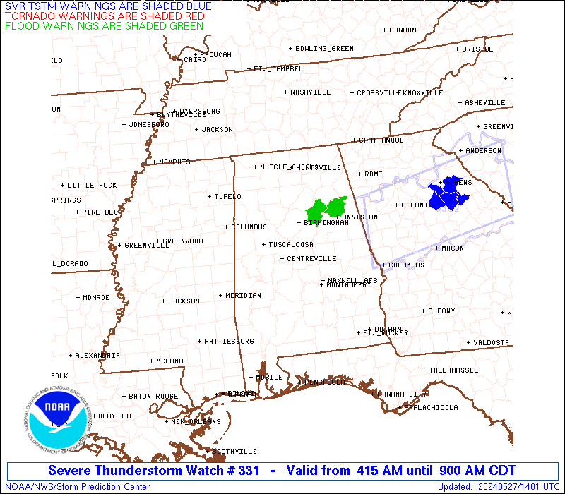
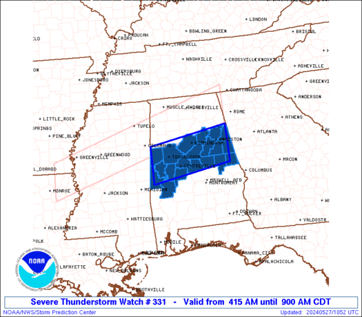
The severe thunderstorm watch area is approximately along and 40
statute miles north and south of a line from 40 miles west southwest
of Tuscaloosa AL to 25 miles east southeast of Anniston AL. For a
complete depiction of the watch see the associated watch outline
update (WOUS64 KWNS WOU1).
PRECAUTIONARY/PREPAREDNESS ACTIONS...
REMEMBER...A Severe Thunderstorm Watch means conditions are
favorable for severe thunderstorms in and close to the watch area.
Persons in these areas should be on the lookout for threatening
weather conditions and listen for later statements and possible
warnings. Severe thunderstorms can and occasionally do produce
tornadoes.
&&
OTHER WATCH INFORMATION...CONTINUE...WW 326...WW 327...WW 330...
AVIATION...A few severe thunderstorms with hail surface and aloft to
1.5 inches. Extreme turbulence and surface wind gusts to 60 knots. A
few cumulonimbi with maximum tops to 550. Mean storm motion vector
24035.
...Edwards

   SEL1

   URGENT - IMMEDIATE BROADCAST REQUESTED
   Severe Thunderstorm Watch Number 331
   NWS Storm Prediction Center Norman OK
   415 AM CDT Mon May 27 2024

   The NWS Storm Prediction Center has issued a

   * Severe Thunderstorm Watch for portions of
     Central Alabama

   * Effective this Monday morning from 415 AM until 900 AM CDT.

   * Primary threats include...
     Scattered damaging wind gusts to 70 mph possible
     Scattered large hail events to 1.5 inches in diameter possible
     A tornado or two possible

   SUMMARY...A cluster of thunderstorms moving rapidly out of eastern
   MS will encounter a favorably moist air mass in AL, along the
   northern rim of stronger capping.  Damaging gusts are the main
   hazard over the watch corridor.  Sporadic hail will be possible, and
   a tornado or two also may occur.

   The severe thunderstorm watch area is approximately along and 40
   statute miles north and south of a line from 40 miles west southwest
   of Tuscaloosa AL to 25 miles east southeast of Anniston AL. For a
   complete depiction of the watch see the associated watch outline
   update (WOUS64 KWNS WOU1).

   PRECAUTIONARY/PREPAREDNESS ACTIONS...

   REMEMBER...A Severe Thunderstorm Watch means conditions are
   favorable for severe thunderstorms in and close to the watch area.
   Persons in these areas should be on the lookout for threatening
   weather conditions and listen for later statements and possible
   warnings. Severe thunderstorms can and occasionally do produce
   tornadoes.

   &&

   OTHER WATCH INFORMATION...CONTINUE...WW 326...WW 327...WW 330...

   AVIATION...A few severe thunderstorms with hail surface and aloft to
   1.5 inches. Extreme turbulence and surface wind gusts to 60 knots. A
   few cumulonimbi with maximum tops to 550. Mean storm motion vector
   24035.

   ...Edwards
 Note:
The Aviation Watch (SAW) product is an approximation to the watch area.
The actual watch is depicted by the shaded areas.
Note:
The Aviation Watch (SAW) product is an approximation to the watch area.
The actual watch is depicted by the shaded areas.
   SAW1
   WW 331 SEVERE TSTM AL 270915Z - 271400Z
   AXIS..40 STATUTE MILES NORTH AND SOUTH OF LINE..
   40WSW TCL/TUSCALOOSA AL/ - 25ESE ANB/ANNISTON AL/
   ..AVIATION COORDS.. 35NM N/S /32SSE IGB - 26NNW LGC/
   HAIL SURFACE AND ALOFT..1.5 INCHES. WIND GUSTS..60 KNOTS.
   MAX TOPS TO 550. MEAN STORM MOTION VECTOR 24035.

   LAT...LON 33588826 34028545 32868545 32418826

   THIS IS AN APPROXIMATION TO THE WATCH AREA.  FOR A
   COMPLETE DEPICTION OF THE WATCH SEE WOUS64 KWNS
   FOR WOU1.
Watch 331 Status Report Messages:
STATUS REPORT #1 ON WW 331

VALID 271035Z - 271140Z

SEVERE WEATHER THREAT CONTINUES RIGHT OF A LINE FROM 30 ENE MEI
TO 10 SSE TCL TO 30 NNW TCL.

..GOSS..05/27/24

ATTN...WFO...BMX...

&&

STATUS REPORT FOR WS 331

SEVERE WEATHER THREAT CONTINUES FOR THE FOLLOWING AREAS

ALC007-015-017-021-027-029-037-065-073-091-105-111-115-117-119-
121-123-125-271140-

AL
.    ALABAMA COUNTIES INCLUDED ARE

BIBB		     CALHOUN		 CHAMBERS
CHILTON 	     CLAY		 CLEBURNE
COOSA		     HALE		 JEFFERSON
MARENGO 	     PERRY		 RANDOLPH
ST. CLAIR	     SHELBY		 SUMTER
TALLADEGA	     TALLAPOOSA 	 TUSCALOOSA
$$


THE WATCH STATUS MESSAGE IS FOR GUIDANCE PURPOSES ONLY.  PLEASE
REFER TO WATCH COUNTY NOTIFICATION STATEMENTS FOR OFFICIAL
INFORMATION ON COUNTIES...INDEPENDENT CITIES AND MARINE ZONES
CLEARED FROM SEVERE THUNDERSTORM AND TORNADO WATCHES.
$$
Note:
Click for Complete Product Text.
Tornadoes
Probability of 2 or more tornadoes
|
Low (20%)
|
Probability of 1 or more strong (EF2-EF5) tornadoes
|
Low (<2%)
|
Wind
Probability of 10 or more severe wind events
|
Mod (40%)
|
Probability of 1 or more wind events > 65 knots
|
Low (20%)
|
Hail
Probability of 10 or more severe hail events
|
Mod (40%)
|
Probability of 1 or more hailstones > 2 inches
|
Low (20%)
|
Combined Severe Hail/Wind
Probability of 6 or more combined severe hail/wind events
|
High (70%)
|
For each watch, probabilities for particular events inside the watch
(listed above in each table) are determined by the issuing forecaster.
The "Low" category contains probability values ranging from less than 2%
to 20% (EF2-EF5 tornadoes), less than 5% to 20% (all other probabilities),
"Moderate" from 30% to 60%, and "High" from 70% to greater than 95%.
High values are bolded and lighter in color to provide awareness of
an increased threat for a particular event.


 @NWSSPC