Note:
The expiration time in the watch graphic is amended if the watch is
replaced, cancelled or extended.
Note:
Note:
The expiration time in the watch graphic is amended if the watch is
replaced, cancelled or extended.
Note: Click for
Watch Status Reports.
SEL7
URGENT - IMMEDIATE BROADCAST REQUESTED
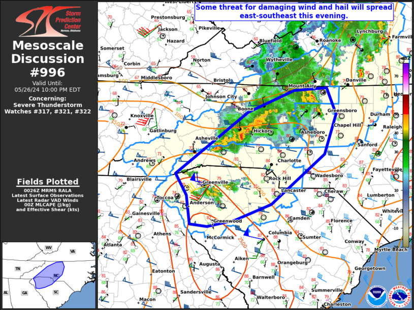
Severe Thunderstorm Watch Number 317
NWS Storm Prediction Center Norman OK
145 PM EDT Sun May 26 2024
The NWS Storm Prediction Center has issued a
* Severe Thunderstorm Watch for portions of
Eastern Kentucky
Western North Carolina
Southeast Ohio
Eastern Tennessee
Southwest Virginia
Central and Southern West Virginia
* Effective this Sunday afternoon and evening from 145 PM until
900 PM EDT.
* Primary threats include...
Scattered damaging wind gusts to 70 mph likely
Isolated large hail events to 1.5 inches in diameter possible
A tornado or two possible
SUMMARY...A bowing complex of severe thunderstorms will continue
moving east through the remainder of this afternoon and early
evening. Damaging thunderstorm wind gusts and a tornado or two will
be the primary severe weather hazards, however isolated large hail
will also be possible.
The severe thunderstorm watch area is approximately along and 60
statute miles north and south of a line from 55 miles west northwest
of Bristol TN to 20 miles northeast of Dublin VA. For a complete
depiction of the watch see the associated watch outline update
(WOUS64 KWNS WOU7).
PRECAUTIONARY/PREPAREDNESS ACTIONS...
REMEMBER...A Severe Thunderstorm Watch means conditions are
favorable for severe thunderstorms in and close to the watch area.
Persons in these areas should be on the lookout for threatening
weather conditions and listen for later statements and possible
warnings. Severe thunderstorms can and occasionally do produce
tornadoes.
&&
OTHER WATCH INFORMATION...CONTINUE...WW 315...WW 316...
AVIATION...A few severe thunderstorms with hail surface and aloft to
1.5 inches. Extreme turbulence and surface wind gusts to 60 knots. A
few cumulonimbi with maximum tops to 500. Mean storm motion vector
25040.
...Bunting

   SEL7

   URGENT - IMMEDIATE BROADCAST REQUESTED
   Severe Thunderstorm Watch Number 317
   NWS Storm Prediction Center Norman OK
   145 PM EDT Sun May 26 2024

   The NWS Storm Prediction Center has issued a

   * Severe Thunderstorm Watch for portions of
     Eastern Kentucky
     Western North Carolina
     Southeast Ohio
     Eastern Tennessee
     Southwest Virginia
     Central and Southern West Virginia

   * Effective this Sunday afternoon and evening from 145 PM until
     900 PM EDT.

   * Primary threats include...
     Scattered damaging wind gusts to 70 mph likely
     Isolated large hail events to 1.5 inches in diameter possible
     A tornado or two possible

   SUMMARY...A bowing complex of severe thunderstorms will continue
   moving east through the remainder of this afternoon and early
   evening. Damaging thunderstorm wind gusts and a tornado or two will
   be the primary severe weather hazards, however isolated large hail
   will also be possible.

   The severe thunderstorm watch area is approximately along and 60
   statute miles north and south of a line from 55 miles west northwest
   of Bristol TN to 20 miles northeast of Dublin VA. For a complete
   depiction of the watch see the associated watch outline update
   (WOUS64 KWNS WOU7).

   PRECAUTIONARY/PREPAREDNESS ACTIONS...

   REMEMBER...A Severe Thunderstorm Watch means conditions are
   favorable for severe thunderstorms in and close to the watch area.
   Persons in these areas should be on the lookout for threatening
   weather conditions and listen for later statements and possible
   warnings. Severe thunderstorms can and occasionally do produce
   tornadoes.

   &&

   OTHER WATCH INFORMATION...CONTINUE...WW 315...WW 316...

   AVIATION...A few severe thunderstorms with hail surface and aloft to
   1.5 inches. Extreme turbulence and surface wind gusts to 60 knots. A
   few cumulonimbi with maximum tops to 500. Mean storm motion vector
   25040.

   ...Bunting
 Note:
The Aviation Watch (SAW) product is an approximation to the watch area.
The actual watch is depicted by the shaded areas.
Note:
The Aviation Watch (SAW) product is an approximation to the watch area.
The actual watch is depicted by the shaded areas.
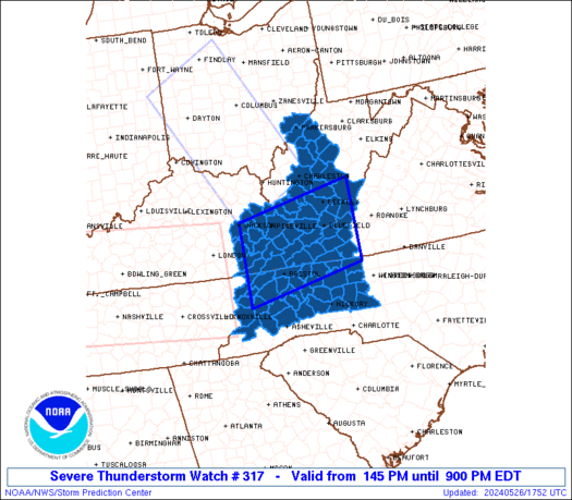
   SAW7
   WW 317 SEVERE TSTM KY NC OH TN VA WV 261745Z - 270100Z
   AXIS..60 STATUTE MILES NORTH AND SOUTH OF LINE..
   55WNW TRI/BRISTOL TN/ - 20NE PSK/DUBLIN VA/
   ..AVIATION COORDS.. 50NM N/S /42ESE LOZ - 20NE PSK/
   HAIL SURFACE AND ALOFT..1.5 INCHES. WIND GUSTS..60 KNOTS.
   MAX TOPS TO 500. MEAN STORM MOTION VECTOR 25040.

   LAT...LON 37648332 38208042 36478042 35908332

   THIS IS AN APPROXIMATION TO THE WATCH AREA.  FOR A
   COMPLETE DEPICTION OF THE WATCH SEE WOUS64 KWNS
   FOR WOU7.
Watch 317 Status Report Messages:
STATUS REPORT #4 ON WW 317

VALID 270015Z - 270140Z

SEVERE WEATHER THREAT CONTINUES RIGHT OF A LINE FROM 30 WSW AVL
TO 35 WNW HKY TO 50 S PSK TO 30 SSE PSK TO 15 SSE ROA.

..LYONS..05/27/24

ATTN...WFO...JKL...GSP...RNK...RLX...MRX...

&&

STATUS REPORT FOR WS 317

SEVERE WEATHER THREAT CONTINUES FOR THE FOLLOWING AREAS

NCC003-021-023-027-035-059-097-111-157-159-169-171-193-197-
270140-

NC
.    NORTH CAROLINA COUNTIES INCLUDED ARE

ALEXANDER	     BUNCOMBE		 BURKE
CALDWELL	     CATAWBA		 DAVIE
IREDELL 	     MCDOWELL		 ROCKINGHAM
ROWAN		     STOKES		 SURRY
WILKES		     YADKIN
$$


VAC089-141-690-270140-

VA
.    VIRGINIA COUNTIES INCLUDED ARE

HENRY		     PATRICK


VIRGINIA INDEPENDENT CITIES INCLUDED ARE

MARTINSVILLE
$$


THE WATCH STATUS MESSAGE IS FOR GUIDANCE PURPOSES ONLY.  PLEASE
REFER TO WATCH COUNTY NOTIFICATION STATEMENTS FOR OFFICIAL
INFORMATION ON COUNTIES...INDEPENDENT CITIES AND MARINE ZONES
CLEARED FROM SEVERE THUNDERSTORM AND TORNADO WATCHES.
$$

STATUS REPORT #3 ON WW 317

VALID 262200Z - 262340Z

SEVERE WEATHER THREAT CONTINUES RIGHT OF A LINE FROM 20 W TYS TO
45 WNW TRI TO 40 W BLF TO 20 SW BKW TO 25 N BKW TO 20 SSE PKB TO
30 ESE ZZV.

..LYONS..05/26/24

ATTN...WFO...JKL...GSP...RNK...RLX...MRX...

&&

STATUS REPORT FOR WS 317

SEVERE WEATHER THREAT CONTINUES FOR THE FOLLOWING AREAS

KYC051-131-262340-

KY
.    KENTUCKY COUNTIES INCLUDED ARE

CLAY		     LESLIE
$$


NCC003-005-009-011-021-023-027-035-059-075-087-097-099-111-113-
115-121-157-159-169-171-173-189-193-197-199-262340-

NC
.    NORTH CAROLINA COUNTIES INCLUDED ARE

ALEXANDER	     ALLEGHANY		 ASHE
AVERY		     BUNCOMBE		 BURKE
CALDWELL	     CATAWBA		 DAVIE
GRAHAM		     HAYWOOD		 IREDELL
JACKSON 	     MCDOWELL		 MACON
MADISON 	     MITCHELL		 ROCKINGHAM
ROWAN		     STOKES		 SURRY
SWAIN		     WATAUGA		 WILKES
YADKIN		     YANCEY
$$


TNC001-009-019-029-057-059-063-067-073-089-091-093-105-123-139-
145-155-163-171-173-179-262340-

TN
.    TENNESSEE COUNTIES INCLUDED ARE

ANDERSON	     BLOUNT		 CARTER
COCKE		     GRAINGER		 GREENE
HAMBLEN 	     HANCOCK		 HAWKINS
JEFFERSON	     JOHNSON		 KNOX
LOUDON		     MONROE		 POLK
ROANE		     SEVIER		 SULLIVAN
UNICOI		     UNION		 WASHINGTON
$$


VAC021-023-027-035-045-051-063-067-071-077-089-105-121-141-155-
167-169-173-185-191-195-197-520-580-640-690-720-750-770-775-
262340-

VA
.    VIRGINIA COUNTIES INCLUDED ARE

BLAND		     BOTETOURT		 BUCHANAN
CARROLL 	     CRAIG		 DICKENSON
FLOYD		     FRANKLIN		 GILES
GRAYSON 	     HENRY		 LEE
MONTGOMERY	     PATRICK		 PULASKI
RUSSELL 	     SCOTT		 SMYTH
TAZEWELL	     WASHINGTON 	 WISE
WYTHE


VIRGINIA INDEPENDENT CITIES INCLUDED ARE

BRISTOL 	     COVINGTON		 GALAX
MARTINSVILLE	     NORTON		 RADFORD
ROANOKE 	     SALEM
$$


WVC001-007-013-015-017-019-021-025-033-041-047-055-063-067-073-
075-081-083-085-089-091-095-097-101-262340-

WV
.    WEST VIRGINIA COUNTIES INCLUDED ARE

BARBOUR 	     BRAXTON		 CALHOUN
CLAY		     DODDRIDGE		 FAYETTE
GILMER		     GREENBRIER 	 HARRISON
LEWIS		     MCDOWELL		 MERCER
MONROE		     NICHOLAS		 PLEASANTS
POCAHONTAS	     RALEIGH		 RANDOLPH
RITCHIE 	     SUMMERS		 TAYLOR
TYLER		     UPSHUR		 WEBSTER
$$


THE WATCH STATUS MESSAGE IS FOR GUIDANCE PURPOSES ONLY.  PLEASE
REFER TO WATCH COUNTY NOTIFICATION STATEMENTS FOR OFFICIAL
INFORMATION ON COUNTIES...INDEPENDENT CITIES AND MARINE ZONES
CLEARED FROM SEVERE THUNDERSTORM AND TORNADO WATCHES.
$$

STATUS REPORT #2 ON WW 317

VALID 262010Z - 262140Z

THE SEVERE WEATHER THREAT CONTINUES ACROSS THE ENTIRE WATCH AREA.

..LYONS..05/26/24

ATTN...WFO...JKL...GSP...RNK...RLX...MRX...

&&

STATUS REPORT FOR WS 317

SEVERE WEATHER THREAT CONTINUES FOR THE FOLLOWING AREAS

KYC025-071-095-115-119-131-133-153-159-193-195-262140-

KY
.    KENTUCKY COUNTIES INCLUDED ARE

BREATHITT	     FLOYD		 HARLAN
JOHNSON 	     KNOTT		 LESLIE
LETCHER 	     MAGOFFIN		 MARTIN
PERRY		     PIKE
$$


NCC003-005-009-011-021-023-027-035-059-087-097-111-115-121-159-
171-173-189-193-197-199-262140-

NC
.    NORTH CAROLINA COUNTIES INCLUDED ARE

ALEXANDER	     ALLEGHANY		 ASHE
AVERY		     BUNCOMBE		 BURKE
CALDWELL	     CATAWBA		 DAVIE
HAYWOOD 	     IREDELL		 MCDOWELL
MADISON 	     MITCHELL		 ROWAN
SURRY		     SWAIN		 WATAUGA
WILKES		     YADKIN		 YANCEY
$$


OHC167-262140-

OH
.    OHIO COUNTIES INCLUDED ARE

WASHINGTON
$$


TNC019-029-057-059-063-067-073-089-091-155-163-171-179-262140-

TN
.    TENNESSEE COUNTIES INCLUDED ARE

CARTER		     COCKE		 GRAINGER
GREENE		     HAMBLEN		 HANCOCK
HAWKINS 	     JEFFERSON		 JOHNSON
SEVIER		     SULLIVAN		 UNICOI
WASHINGTON
$$


VAC021-027-035-051-071-077-105-155-167-169-173-185-191-195-197-
520-640-720-262140-

VA
.    VIRGINIA COUNTIES INCLUDED ARE

BLAND		     BUCHANAN		 CARROLL
DICKENSON	     GILES		 GRAYSON
LEE		     PULASKI		 RUSSELL
SCOTT		     SMYTH		 TAZEWELL
WASHINGTON	     WISE		 WYTHE


VIRGINIA INDEPENDENT CITIES INCLUDED ARE

BRISTOL 	     GALAX		 NORTON
$$


WVC005-007-013-015-019-021-025-039-045-047-055-059-063-067-073-
081-085-087-089-105-107-109-262140-

WV
.    WEST VIRGINIA COUNTIES INCLUDED ARE

BOONE		     BRAXTON		 CALHOUN
CLAY		     FAYETTE		 GILMER
GREENBRIER	     KANAWHA		 LOGAN
MCDOWELL	     MERCER		 MINGO
MONROE		     NICHOLAS		 PLEASANTS
RALEIGH 	     RITCHIE		 ROANE
SUMMERS 	     WIRT		 WOOD
WYOMING
$$


THE WATCH STATUS MESSAGE IS FOR GUIDANCE PURPOSES ONLY.  PLEASE
REFER TO WATCH COUNTY NOTIFICATION STATEMENTS FOR OFFICIAL
INFORMATION ON COUNTIES...INDEPENDENT CITIES AND MARINE ZONES
CLEARED FROM SEVERE THUNDERSTORM AND TORNADO WATCHES.
$$

STATUS REPORT #1 ON WW 317

VALID 261830Z - 261940Z

THE SEVERE WEATHER THREAT CONTINUES ACROSS THE ENTIRE WATCH AREA.

..LYONS..05/26/24

ATTN...WFO...JKL...GSP...RNK...RLX...MRX...

&&

STATUS REPORT FOR WS 317

SEVERE WEATHER THREAT CONTINUES FOR THE FOLLOWING AREAS

KYC025-071-095-115-119-131-133-153-159-193-195-261940-

KY
.    KENTUCKY COUNTIES INCLUDED ARE

BREATHITT	     FLOYD		 HARLAN
JOHNSON 	     KNOTT		 LESLIE
LETCHER 	     MAGOFFIN		 MARTIN
PERRY		     PIKE
$$


NCC003-005-009-011-021-023-027-035-059-087-097-111-115-121-159-
171-173-189-193-197-199-261940-

NC
.    NORTH CAROLINA COUNTIES INCLUDED ARE

ALEXANDER	     ALLEGHANY		 ASHE
AVERY		     BUNCOMBE		 BURKE
CALDWELL	     CATAWBA		 DAVIE
HAYWOOD 	     IREDELL		 MCDOWELL
MADISON 	     MITCHELL		 ROWAN
SURRY		     SWAIN		 WATAUGA
WILKES		     YADKIN		 YANCEY
$$


OHC167-261940-

OH
.    OHIO COUNTIES INCLUDED ARE

WASHINGTON
$$


TNC019-029-057-059-063-067-073-089-091-155-163-171-179-261940-

TN
.    TENNESSEE COUNTIES INCLUDED ARE

CARTER		     COCKE		 GRAINGER
GREENE		     HAMBLEN		 HANCOCK
HAWKINS 	     JEFFERSON		 JOHNSON
SEVIER		     SULLIVAN		 UNICOI
WASHINGTON
$$


VAC021-027-035-051-071-077-105-155-167-169-173-185-191-195-197-
520-640-720-261940-

VA
.    VIRGINIA COUNTIES INCLUDED ARE

BLAND		     BUCHANAN		 CARROLL
DICKENSON	     GILES		 GRAYSON
LEE		     PULASKI		 RUSSELL
SCOTT		     SMYTH		 TAZEWELL
WASHINGTON	     WISE		 WYTHE


VIRGINIA INDEPENDENT CITIES INCLUDED ARE

BRISTOL 	     GALAX		 NORTON
$$


WVC005-007-013-015-019-021-025-039-045-047-055-059-063-067-073-
081-085-087-089-105-107-109-261940-

WV
.    WEST VIRGINIA COUNTIES INCLUDED ARE

BOONE		     BRAXTON		 CALHOUN
CLAY		     FAYETTE		 GILMER
GREENBRIER	     KANAWHA		 LOGAN
MCDOWELL	     MERCER		 MINGO
MONROE		     NICHOLAS		 PLEASANTS
RALEIGH 	     RITCHIE		 ROANE
SUMMERS 	     WIRT		 WOOD
WYOMING
$$


THE WATCH STATUS MESSAGE IS FOR GUIDANCE PURPOSES ONLY.  PLEASE
REFER TO WATCH COUNTY NOTIFICATION STATEMENTS FOR OFFICIAL
INFORMATION ON COUNTIES...INDEPENDENT CITIES AND MARINE ZONES
CLEARED FROM SEVERE THUNDERSTORM AND TORNADO WATCHES.
$$
Note:
Click for Complete Product Text.
Tornadoes
Probability of 2 or more tornadoes
|
Low (20%)
|
Probability of 1 or more strong (EF2-EF5) tornadoes
|
Low (5%)
|
Wind
Probability of 10 or more severe wind events
|
Mod (60%)
|
Probability of 1 or more wind events > 65 knots
|
Low (10%)
|
Hail
Probability of 10 or more severe hail events
|
Low (20%)
|
Probability of 1 or more hailstones > 2 inches
|
Low (10%)
|
Combined Severe Hail/Wind
Probability of 6 or more combined severe hail/wind events
|
High (80%)
|
For each watch, probabilities for particular events inside the watch
(listed above in each table) are determined by the issuing forecaster.
The "Low" category contains probability values ranging from less than 2%
to 20% (EF2-EF5 tornadoes), less than 5% to 20% (all other probabilities),
"Moderate" from 30% to 60%, and "High" from 70% to greater than 95%.
High values are bolded and lighter in color to provide awareness of
an increased threat for a particular event.


 @NWSSPC