 Note:
The expiration time in the watch graphic is amended if the watch is
replaced, cancelled or extended.
Note:
Note:
The expiration time in the watch graphic is amended if the watch is
replaced, cancelled or extended.
Note: Click for
Watch Status Reports.
SEL3
URGENT - IMMEDIATE BROADCAST REQUESTED
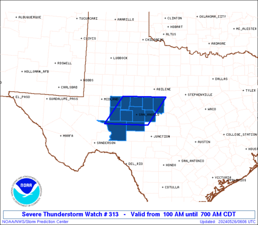
Severe Thunderstorm Watch Number 313
NWS Storm Prediction Center Norman OK
100 AM CDT Sun May 26 2024
The NWS Storm Prediction Center has issued a
* Severe Thunderstorm Watch for portions of
West-central Texas
* Effective this Sunday morning from 100 AM until 700 AM CDT.
* Primary threats include...
Scattered large hail and isolated very large hail events to 3
inches in diameter possible
Isolated damaging wind gusts to 60 mph possible
SUMMARY...Thunderstorms have developed along a dryline over the
eastern Permian Basin area, with additional towers evident to the
south in satellite imagery. The environment supports significant
(2+ inch) damaging hail with any storms that can persist, as
convection shifts eastward toward the Concho Valley region. Though
capping strengthens eastward from the dryline, isolated severe gusts
also may occur.
The severe thunderstorm watch area is approximately along and 60
statute miles east and west of a line from 40 miles southwest of San
Angelo TX to 55 miles north northeast of San Angelo TX. For a
complete depiction of the watch see the associated watch outline
update (WOUS64 KWNS WOU3).
PRECAUTIONARY/PREPAREDNESS ACTIONS...
REMEMBER...A Severe Thunderstorm Watch means conditions are
favorable for severe thunderstorms in and close to the watch area.
Persons in these areas should be on the lookout for threatening
weather conditions and listen for later statements and possible
warnings. Severe thunderstorms can and occasionally do produce
tornadoes.
&&
OTHER WATCH INFORMATION...CONTINUE...WW 309...WW 310...WW
311...WW 312...
AVIATION...A few severe thunderstorms with hail surface and aloft to
3 inches. Extreme turbulence and surface wind gusts to 50 knots. A
few cumulonimbi with maximum tops to 600. Mean storm motion vector
27025.
...Edwards

   SEL3

   URGENT - IMMEDIATE BROADCAST REQUESTED
   Severe Thunderstorm Watch Number 313
   NWS Storm Prediction Center Norman OK
   100 AM CDT Sun May 26 2024

   The NWS Storm Prediction Center has issued a

   * Severe Thunderstorm Watch for portions of
     West-central Texas

   * Effective this Sunday morning from 100 AM until 700 AM CDT.

   * Primary threats include...
     Scattered large hail and isolated very large hail events to 3
       inches in diameter possible
     Isolated damaging wind gusts to 60 mph possible

   SUMMARY...Thunderstorms have developed along a dryline over the
   eastern Permian Basin area, with additional towers evident to the
   south in satellite imagery.  The environment supports significant
   (2+ inch) damaging hail with any storms that can persist, as
   convection shifts eastward toward the Concho Valley region.  Though
   capping strengthens eastward from the dryline, isolated severe gusts
   also may occur.

   The severe thunderstorm watch area is approximately along and 60
   statute miles east and west of a line from 40 miles southwest of San
   Angelo TX to 55 miles north northeast of San Angelo TX. For a
   complete depiction of the watch see the associated watch outline
   update (WOUS64 KWNS WOU3).

   PRECAUTIONARY/PREPAREDNESS ACTIONS...

   REMEMBER...A Severe Thunderstorm Watch means conditions are
   favorable for severe thunderstorms in and close to the watch area.
   Persons in these areas should be on the lookout for threatening
   weather conditions and listen for later statements and possible
   warnings. Severe thunderstorms can and occasionally do produce
   tornadoes.

   &&

   OTHER WATCH INFORMATION...CONTINUE...WW 309...WW 310...WW
   311...WW 312...

   AVIATION...A few severe thunderstorms with hail surface and aloft to
   3 inches. Extreme turbulence and surface wind gusts to 50 knots. A
   few cumulonimbi with maximum tops to 600. Mean storm motion vector
   27025.

   ...Edwards
 Note:
The Aviation Watch (SAW) product is an approximation to the watch area.
The actual watch is depicted by the shaded areas.
Note:
The Aviation Watch (SAW) product is an approximation to the watch area.
The actual watch is depicted by the shaded areas.
   SAW3
   WW 313 SEVERE TSTM TX 260600Z - 261200Z
   AXIS..60 STATUTE MILES EAST AND WEST OF LINE..
   40SW SJT/SAN ANGELO TX/ - 55NNE SJT/SAN ANGELO TX/
   ..AVIATION COORDS.. 50NM E/W /37SW SJT - 27SSW ABI/
   HAIL SURFACE AND ALOFT..3 INCHES. WIND GUSTS..50 KNOTS.
   MAX TOPS TO 600. MEAN STORM MOTION VECTOR 27025.

   LAT...LON 30960199 32090117 32099912 30969996

   THIS IS AN APPROXIMATION TO THE WATCH AREA.  FOR A
   COMPLETE DEPICTION OF THE WATCH SEE WOUS64 KWNS
   FOR WOU3.
Watch 313 Status Report Messages:
STATUS REPORT #4 ON WW 313

VALID 260955Z - 261040Z

SEVERE WEATHER THREAT CONTINUES RIGHT OF A LINE FROM 40 SW SJT TO
5 E SJT TO 30 WSW BWD.

..GOSS..05/26/24

ATTN...WFO...SJT...MAF...

&&

STATUS REPORT FOR WS 313

SEVERE WEATHER THREAT CONTINUES FOR THE FOLLOWING AREAS

TXC049-095-105-413-451-261040-

TX
.    TEXAS COUNTIES INCLUDED ARE

BROWN		     CONCHO		 CROCKETT
SCHLEICHER	     TOM GREEN
$$


THE WATCH STATUS MESSAGE IS FOR GUIDANCE PURPOSES ONLY.  PLEASE
REFER TO WATCH COUNTY NOTIFICATION STATEMENTS FOR OFFICIAL
INFORMATION ON COUNTIES...INDEPENDENT CITIES AND MARINE ZONES
CLEARED FROM SEVERE THUNDERSTORM AND TORNADO WATCHES.
$$

STATUS REPORT #3 ON WW 313

VALID 260850Z - 260940Z

SEVERE WEATHER THREAT CONTINUES RIGHT OF A LINE FROM 55 E FST TO
20 NNW BWD.

..GOSS..05/26/24

ATTN...WFO...SJT...MAF...

&&

STATUS REPORT FOR WS 313

SEVERE WEATHER THREAT CONTINUES FOR THE FOLLOWING AREAS

TXC083-095-105-235-383-399-413-451-260940-

TX
.    TEXAS COUNTIES INCLUDED ARE

COLEMAN 	     CONCHO		 CROCKETT
IRION		     REAGAN		 RUNNELS
SCHLEICHER	     TOM GREEN
$$


THE WATCH STATUS MESSAGE IS FOR GUIDANCE PURPOSES ONLY.  PLEASE
REFER TO WATCH COUNTY NOTIFICATION STATEMENTS FOR OFFICIAL
INFORMATION ON COUNTIES...INDEPENDENT CITIES AND MARINE ZONES
CLEARED FROM SEVERE THUNDERSTORM AND TORNADO WATCHES.
$$

STATUS REPORT #2 ON WW 313

VALID 260740Z - 260840Z

SEVERE WEATHER THREAT CONTINUES RIGHT OF A LINE FROM 55 SSE MAF
TO 25 SSW ABI.

..GOSS..05/26/24

ATTN...WFO...SJT...MAF...

&&

STATUS REPORT FOR WS 313

SEVERE WEATHER THREAT CONTINUES FOR THE FOLLOWING AREAS

TXC081-083-095-105-235-383-399-413-451-260840-

TX
.    TEXAS COUNTIES INCLUDED ARE

COKE		     COLEMAN		 CONCHO
CROCKETT	     IRION		 REAGAN
RUNNELS 	     SCHLEICHER 	 TOM GREEN
$$


THE WATCH STATUS MESSAGE IS FOR GUIDANCE PURPOSES ONLY.  PLEASE
REFER TO WATCH COUNTY NOTIFICATION STATEMENTS FOR OFFICIAL
INFORMATION ON COUNTIES...INDEPENDENT CITIES AND MARINE ZONES
CLEARED FROM SEVERE THUNDERSTORM AND TORNADO WATCHES.
$$

STATUS REPORT #1 ON WW 313

VALID 260705Z - 260840Z

SEVERE WEATHER THREAT CONTINUES RIGHT OF A LINE FROM 40 SE MAF TO
35 SW ABI.

..GOSS..05/26/24

ATTN...WFO...SJT...MAF...

&&

STATUS REPORT FOR WS 313

SEVERE WEATHER THREAT CONTINUES FOR THE FOLLOWING AREAS

TXC081-083-095-105-235-383-399-413-431-451-260840-

TX
.    TEXAS COUNTIES INCLUDED ARE

COKE		     COLEMAN		 CONCHO
CROCKETT	     IRION		 REAGAN
RUNNELS 	     SCHLEICHER 	 STERLING
TOM GREEN
$$


THE WATCH STATUS MESSAGE IS FOR GUIDANCE PURPOSES ONLY.  PLEASE
REFER TO WATCH COUNTY NOTIFICATION STATEMENTS FOR OFFICIAL
INFORMATION ON COUNTIES...INDEPENDENT CITIES AND MARINE ZONES
CLEARED FROM SEVERE THUNDERSTORM AND TORNADO WATCHES.
$$
Note:
Click for Complete Product Text.
Tornadoes
Probability of 2 or more tornadoes
|
Low (10%)
|
Probability of 1 or more strong (EF2-EF5) tornadoes
|
Low (5%)
|
Wind
Probability of 10 or more severe wind events
|
Low (20%)
|
Probability of 1 or more wind events > 65 knots
|
Low (20%)
|
Hail
Probability of 10 or more severe hail events
|
Mod (40%)
|
Probability of 1 or more hailstones > 2 inches
|
Mod (40%)
|
Combined Severe Hail/Wind
Probability of 6 or more combined severe hail/wind events
|
Mod (60%)
|
For each watch, probabilities for particular events inside the watch
(listed above in each table) are determined by the issuing forecaster.
The "Low" category contains probability values ranging from less than 2%
to 20% (EF2-EF5 tornadoes), less than 5% to 20% (all other probabilities),
"Moderate" from 30% to 60%, and "High" from 70% to greater than 95%.
High values are bolded and lighter in color to provide awareness of
an increased threat for a particular event.


 @NWSSPC


