Note:
The expiration time in the watch graphic is amended if the watch is
replaced, cancelled or extended.
Note:
Note:
The expiration time in the watch graphic is amended if the watch is
replaced, cancelled or extended.
Note: Click for
Watch Status Reports.
SEL6
URGENT - IMMEDIATE BROADCAST REQUESTED
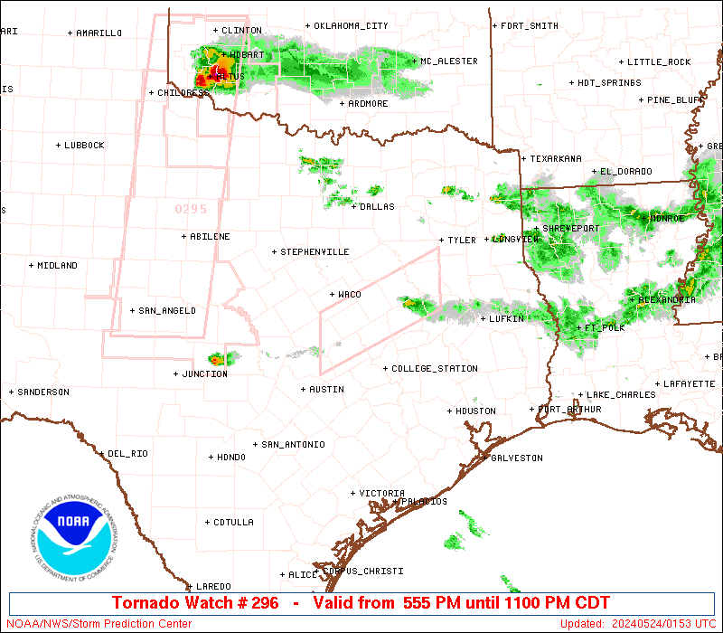
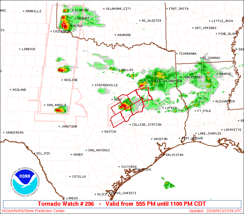
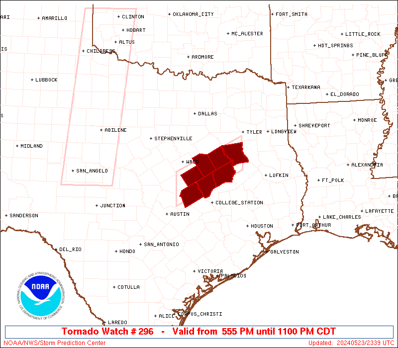
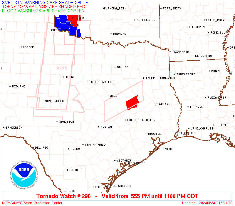
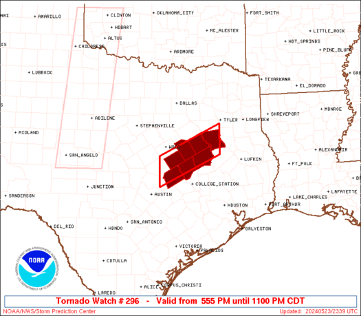
Tornado Watch Number 296
NWS Storm Prediction Center Norman OK
555 PM CDT Thu May 23 2024
The NWS Storm Prediction Center has issued a
* Tornado Watch for portions of
Central Texas
* Effective this Thursday afternoon and evening from 555 PM until
1100 PM CDT.
* Primary threats include...
A couple tornadoes possible
Scattered large hail and isolated very large hail events to 2.5
inches in diameter possible
Isolated damaging wind gusts to 70 mph possible
SUMMARY...An isolated supercell or two will pose a threat for a
couple of tornadoes, isolated very large hail up to 2.5 inches in
diameter and isolated damaging gusts of 60-70 mph for the next few
hours.
The tornado watch area is approximately along and 30 statute miles
north and south of a line from 15 miles south of Temple TX to 125
miles east northeast of Temple TX. For a complete depiction of the
watch see the associated watch outline update (WOUS64 KWNS WOU6).
PRECAUTIONARY/PREPAREDNESS ACTIONS...
REMEMBER...A Tornado Watch means conditions are favorable for
tornadoes and severe thunderstorms in and close to the watch
area. Persons in these areas should be on the lookout for
threatening weather conditions and listen for later statements
and possible warnings.
&&
OTHER WATCH INFORMATION...CONTINUE...WW 293...WW 294...WW 295...
AVIATION...Tornadoes and a few severe thunderstorms with hail
surface and aloft to 2.5 inches. Extreme turbulence and surface wind
gusts to 60 knots. A few cumulonimbi with maximum tops to 600. Mean
storm motion vector 27020.
...Thompson

   SEL6

   URGENT - IMMEDIATE BROADCAST REQUESTED
   Tornado Watch Number 296
   NWS Storm Prediction Center Norman OK
   555 PM CDT Thu May 23 2024

   The NWS Storm Prediction Center has issued a

   * Tornado Watch for portions of
     Central Texas

   * Effective this Thursday afternoon and evening from 555 PM until
     1100 PM CDT.

   * Primary threats include...
     A couple tornadoes possible
     Scattered large hail and isolated very large hail events to 2.5
       inches in diameter possible
     Isolated damaging wind gusts to 70 mph possible

   SUMMARY...An isolated supercell or two will pose a threat for a
   couple of tornadoes, isolated very large hail up to 2.5 inches in
   diameter and isolated damaging gusts of 60-70 mph for the next few
   hours.

   The tornado watch area is approximately along and 30 statute miles
   north and south of a line from 15 miles south of Temple TX to 125
   miles east northeast of Temple TX. For a complete depiction of the
   watch see the associated watch outline update (WOUS64 KWNS WOU6).

   PRECAUTIONARY/PREPAREDNESS ACTIONS...

   REMEMBER...A Tornado Watch means conditions are favorable for
   tornadoes and severe thunderstorms in and close to the watch
   area. Persons in these areas should be on the lookout for
   threatening weather conditions and listen for later statements
   and possible warnings.

   &&

   OTHER WATCH INFORMATION...CONTINUE...WW 293...WW 294...WW 295...

   AVIATION...Tornadoes and a few severe thunderstorms with hail
   surface and aloft to 2.5 inches. Extreme turbulence and surface wind
   gusts to 60 knots. A few cumulonimbi with maximum tops to 600. Mean
   storm motion vector 27020.

   ...Thompson
 Note:
The Aviation Watch (SAW) product is an approximation to the watch area.
The actual watch is depicted by the shaded areas.
Note:
The Aviation Watch (SAW) product is an approximation to the watch area.
The actual watch is depicted by the shaded areas.
   SAW6
   WW 296 TORNADO TX 232255Z - 240400Z
   AXIS..30 STATUTE MILES NORTH AND SOUTH OF LINE..
   15S TPL/TEMPLE TX/ - 125ENE TPL/TEMPLE TX/
   ..AVIATION COORDS.. 25NM N/S /34N CWK - 50SW GGG/
   HAIL SURFACE AND ALOFT..2.5 INCHES. WIND GUSTS..60 KNOTS.
   MAX TOPS TO 600. MEAN STORM MOTION VECTOR 27020.

   LAT...LON 31379742 32259545 31399545 30509742

   THIS IS AN APPROXIMATION TO THE WATCH AREA.  FOR A
   COMPLETE DEPICTION OF THE WATCH SEE WOUS64 KWNS
   FOR WOU6.
Watch 296 Status Report Messages:
STATUS REPORT #2 ON WW 296

VALID 240045Z - 240140Z

THE SEVERE WEATHER THREAT CONTINUES ACROSS THE ENTIRE WATCH AREA.

..DEAN..05/24/24

ATTN...WFO...FWD...

&&

STATUS REPORT FOR WT 296

SEVERE WEATHER THREAT CONTINUES FOR THE FOLLOWING AREAS

TXC001-145-161-289-293-331-395-240140-

TX
.    TEXAS COUNTIES INCLUDED ARE

ANDERSON	     FALLS		 FREESTONE
LEON		     LIMESTONE		 MILAM
ROBERTSON
$$


THE WATCH STATUS MESSAGE IS FOR GUIDANCE PURPOSES ONLY.  PLEASE
REFER TO WATCH COUNTY NOTIFICATION STATEMENTS FOR OFFICIAL
INFORMATION ON COUNTIES...INDEPENDENT CITIES AND MARINE ZONES
CLEARED FROM SEVERE THUNDERSTORM AND TORNADO WATCHES.
$$

STATUS REPORT #1 ON WW 296

VALID 232345Z - 240040Z

THE SEVERE WEATHER THREAT CONTINUES ACROSS THE ENTIRE WATCH AREA.

..DEAN..05/23/24

ATTN...WFO...FWD...

&&

STATUS REPORT FOR WT 296

SEVERE WEATHER THREAT CONTINUES FOR THE FOLLOWING AREAS

TXC001-145-161-289-293-331-395-240040-

TX
.    TEXAS COUNTIES INCLUDED ARE

ANDERSON	     FALLS		 FREESTONE
LEON		     LIMESTONE		 MILAM
ROBERTSON
$$


THE WATCH STATUS MESSAGE IS FOR GUIDANCE PURPOSES ONLY.  PLEASE
REFER TO WATCH COUNTY NOTIFICATION STATEMENTS FOR OFFICIAL
INFORMATION ON COUNTIES...INDEPENDENT CITIES AND MARINE ZONES
CLEARED FROM SEVERE THUNDERSTORM AND TORNADO WATCHES.
$$
Note:
Click for Complete Product Text.
Tornadoes
Probability of 2 or more tornadoes
|
Mod (40%)
|
Probability of 1 or more strong (EF2-EF5) tornadoes
|
Low (20%)
|
Wind
Probability of 10 or more severe wind events
|
Mod (30%)
|
Probability of 1 or more wind events > 65 knots
|
Low (20%)
|
Hail
Probability of 10 or more severe hail events
|
Mod (40%)
|
Probability of 1 or more hailstones > 2 inches
|
Mod (40%)
|
Combined Severe Hail/Wind
Probability of 6 or more combined severe hail/wind events
|
High (70%)
|
For each watch, probabilities for particular events inside the watch
(listed above in each table) are determined by the issuing forecaster.
The "Low" category contains probability values ranging from less than 2%
to 20% (EF2-EF5 tornadoes), less than 5% to 20% (all other probabilities),
"Moderate" from 30% to 60%, and "High" from 70% to greater than 95%.
High values are bolded and lighter in color to provide awareness of
an increased threat for a particular event.


 @NWSSPC