Note:
The expiration time in the watch graphic is amended if the watch is
replaced, cancelled or extended.
Note:
Note:
The expiration time in the watch graphic is amended if the watch is
replaced, cancelled or extended.
Note: Click for
Watch Status Reports.
SEL1
URGENT - IMMEDIATE BROADCAST REQUESTED
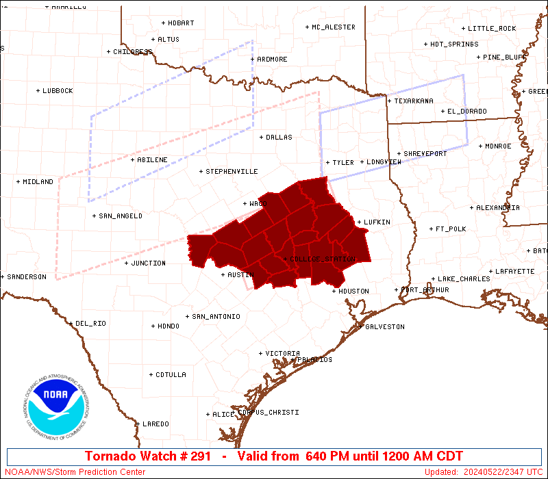
Tornado Watch Number 291
NWS Storm Prediction Center Norman OK
640 PM CDT Wed May 22 2024
The NWS Storm Prediction Center has issued a
* Tornado Watch for portions of
Central and southeast Texas
* Effective this Wednesday night from 640 PM until Midnight CDT.
* Primary threats include...
A couple tornadoes possible
Scattered damaging winds likely with isolated significant gusts
to 80 mph possible
Scattered large hail and isolated very large hail events to 2
inches in diameter possible
SUMMARY...A large supercell cluster with a history of severe wind
gusts/hail will likely continue east-southeastward for the next few
hours. The storm environment will favor gusts up to 80 mph and
large hail of 1-2 inches in diameter, in addition to the potential
for a couple of tornadoes with embedded circulations.
The tornado watch area is approximately along and 45 statute miles
either side of a line from 35 miles south of Temple TX to 50 miles
north northeast of Huntsville TX. For a complete depiction of the
watch see the associated watch outline update (WOUS64 KWNS WOU1).
PRECAUTIONARY/PREPAREDNESS ACTIONS...
REMEMBER...A Tornado Watch means conditions are favorable for
tornadoes and severe thunderstorms in and close to the watch
area. Persons in these areas should be on the lookout for
threatening weather conditions and listen for later statements
and possible warnings.
&&
OTHER WATCH INFORMATION...CONTINUE...WW 286...WW 287...WW
288...WW 289...WW 290...
AVIATION...Tornadoes and a few severe thunderstorms with hail
surface and aloft to 2 inches. Extreme turbulence and surface wind
gusts to 70 knots. A few cumulonimbi with maximum tops to 600. Mean
storm motion vector 29025.
...Thompson
   SEL1

   URGENT - IMMEDIATE BROADCAST REQUESTED
   Tornado Watch Number 291
   NWS Storm Prediction Center Norman OK
   640 PM CDT Wed May 22 2024

   The NWS Storm Prediction Center has issued a

   * Tornado Watch for portions of
     Central and southeast Texas

   * Effective this Wednesday night from 640 PM until Midnight CDT.

   * Primary threats include...
     A couple tornadoes possible
     Scattered damaging winds likely with isolated significant gusts
       to 80 mph possible
     Scattered large hail and isolated very large hail events to 2
       inches in diameter possible

   SUMMARY...A large supercell cluster with a history of severe wind
   gusts/hail will likely continue east-southeastward for the next few
   hours.  The storm environment will favor gusts up to 80 mph and
   large hail of 1-2 inches in diameter, in addition to the potential
   for a couple of tornadoes with embedded circulations.

   The tornado watch area is approximately along and 45 statute miles
   either side of a line from 35 miles south of Temple TX to 50 miles
   north northeast of Huntsville TX. For a complete depiction of the
   watch see the associated watch outline update (WOUS64 KWNS WOU1).

   PRECAUTIONARY/PREPAREDNESS ACTIONS...

   REMEMBER...A Tornado Watch means conditions are favorable for
   tornadoes and severe thunderstorms in and close to the watch
   area. Persons in these areas should be on the lookout for
   threatening weather conditions and listen for later statements
   and possible warnings.

   &&

   OTHER WATCH INFORMATION...CONTINUE...WW 286...WW 287...WW
   288...WW 289...WW 290...

   AVIATION...Tornadoes and a few severe thunderstorms with hail
   surface and aloft to 2 inches. Extreme turbulence and surface wind
   gusts to 70 knots. A few cumulonimbi with maximum tops to 600. Mean
   storm motion vector 29025.

   ...Thompson
 Note:
The Aviation Watch (SAW) product is an approximation to the watch area.
The actual watch is depicted by the shaded areas.
Note:
The Aviation Watch (SAW) product is an approximation to the watch area.
The actual watch is depicted by the shaded areas.
SAW1
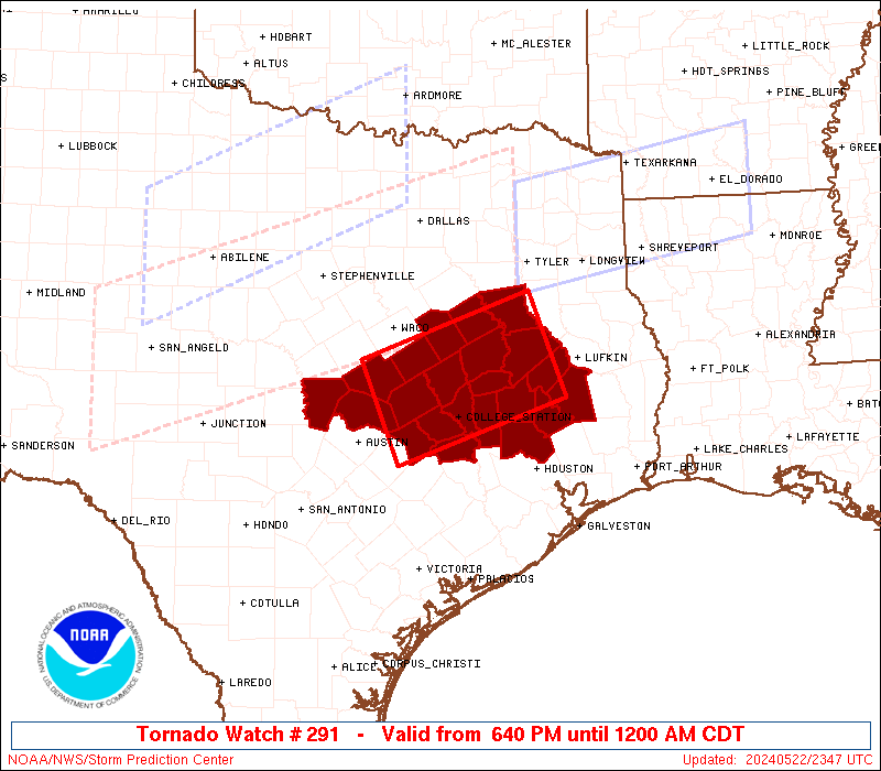
WW 291 TORNADO TX 222340Z - 230500Z
AXIS..45 STATUTE MILES EITHER SIDE OF LINE..
35S TPL/TEMPLE TX/ - 50NNE UTS/HUNTSVILLE TX/
..AVIATION COORDS.. 40NM EITHER SIDE /17NNE CWK - 26WNW LFK/
HAIL SURFACE AND ALOFT..2 INCHES. WIND GUSTS..70 KNOTS.
MAX TOPS TO 600. MEAN STORM MOTION VECTOR 29025.
LAT...LON 31269765 32029538 30789492 30029719
THIS IS AN APPROXIMATION TO THE WATCH AREA. FOR A
COMPLETE DEPICTION OF THE WATCH SEE WOUS64 KWNS
FOR WOU1.
Watch 291 Status Report Messages:
STATUS REPORT #3 ON WW 291

VALID 230245Z - 230340Z

SEVERE WEATHER THREAT CONTINUES RIGHT OF A LINE FROM 40 SE CLL TO
45 NW UTS TO 40 SSE TYR.

..BROYLES..05/23/24

ATTN...WFO...FWD...HGX...EWX...

&&

STATUS REPORT FOR WT 291

SEVERE WEATHER THREAT CONTINUES FOR THE FOLLOWING AREAS

TXC225-313-339-373-407-455-471-230340-

TX
.    TEXAS COUNTIES INCLUDED ARE

HOUSTON 	     MADISON		 MONTGOMERY
POLK		     SAN JACINTO	 TRINITY
WALKER
$$


THE WATCH STATUS MESSAGE IS FOR GUIDANCE PURPOSES ONLY.  PLEASE
REFER TO WATCH COUNTY NOTIFICATION STATEMENTS FOR OFFICIAL
INFORMATION ON COUNTIES...INDEPENDENT CITIES AND MARINE ZONES
CLEARED FROM SEVERE THUNDERSTORM AND TORNADO WATCHES.
$$

STATUS REPORT #2 ON WW 291

VALID 230205Z - 230340Z

THE SEVERE WEATHER THREAT CONTINUES ACROSS THE ENTIRE WATCH AREA.

..BROYLES..05/23/24

ATTN...WFO...FWD...HGX...EWX...

&&

STATUS REPORT FOR WT 291

SEVERE WEATHER THREAT CONTINUES FOR THE FOLLOWING AREAS

TXC001-027-041-051-145-161-185-225-287-289-293-313-331-339-373-
395-407-455-471-477-491-230340-

TX
.    TEXAS COUNTIES INCLUDED ARE

ANDERSON	     BELL		 BRAZOS
BURLESON	     FALLS		 FREESTONE
GRIMES		     HOUSTON		 LEE
LEON		     LIMESTONE		 MADISON
MILAM		     MONTGOMERY 	 POLK
ROBERTSON	     SAN JACINTO	 TRINITY
WALKER		     WASHINGTON 	 WILLIAMSON
$$


THE WATCH STATUS MESSAGE IS FOR GUIDANCE PURPOSES ONLY.  PLEASE
REFER TO WATCH COUNTY NOTIFICATION STATEMENTS FOR OFFICIAL
INFORMATION ON COUNTIES...INDEPENDENT CITIES AND MARINE ZONES
CLEARED FROM SEVERE THUNDERSTORM AND TORNADO WATCHES.
$$

STATUS REPORT #1 ON WW 291

VALID 230055Z - 230140Z

THE SEVERE WEATHER THREAT CONTINUES ACROSS THE ENTIRE WATCH AREA.

..SQUITIERI..05/23/24

ATTN...WFO...FWD...HGX...EWX...

&&

STATUS REPORT FOR WT 291

SEVERE WEATHER THREAT CONTINUES FOR THE FOLLOWING AREAS

TXC001-027-041-051-145-161-185-225-287-289-293-313-331-339-373-
395-407-455-471-477-491-230140-

TX
.    TEXAS COUNTIES INCLUDED ARE

ANDERSON	     BELL		 BRAZOS
BURLESON	     FALLS		 FREESTONE
GRIMES		     HOUSTON		 LEE
LEON		     LIMESTONE		 MADISON
MILAM		     MONTGOMERY 	 POLK
ROBERTSON	     SAN JACINTO	 TRINITY
WALKER		     WASHINGTON 	 WILLIAMSON
$$


THE WATCH STATUS MESSAGE IS FOR GUIDANCE PURPOSES ONLY.  PLEASE
REFER TO WATCH COUNTY NOTIFICATION STATEMENTS FOR OFFICIAL
INFORMATION ON COUNTIES...INDEPENDENT CITIES AND MARINE ZONES
CLEARED FROM SEVERE THUNDERSTORM AND TORNADO WATCHES.
$$
Note:
Click for Complete Product Text.
Tornadoes
Probability of 2 or more tornadoes
|
Mod (40%)
|
Probability of 1 or more strong (EF2-EF5) tornadoes
|
Low (20%)
|
Wind
Probability of 10 or more severe wind events
|
Mod (60%)
|
Probability of 1 or more wind events > 65 knots
|
Mod (40%)
|
Hail
Probability of 10 or more severe hail events
|
Mod (40%)
|
Probability of 1 or more hailstones > 2 inches
|
Mod (30%)
|
Combined Severe Hail/Wind
Probability of 6 or more combined severe hail/wind events
|
High (90%)
|
For each watch, probabilities for particular events inside the watch
(listed above in each table) are determined by the issuing forecaster.
The "Low" category contains probability values ranging from less than 2%
to 20% (EF2-EF5 tornadoes), less than 5% to 20% (all other probabilities),
"Moderate" from 30% to 60%, and "High" from 70% to greater than 95%.
High values are bolded and lighter in color to provide awareness of
an increased threat for a particular event.


 @NWSSPC