 Note:
The expiration time in the watch graphic is amended if the watch is
replaced, cancelled or extended.
Note:
Note:
The expiration time in the watch graphic is amended if the watch is
replaced, cancelled or extended.
Note: Click for
Watch Status Reports.
SEL2
URGENT - IMMEDIATE BROADCAST REQUESTED
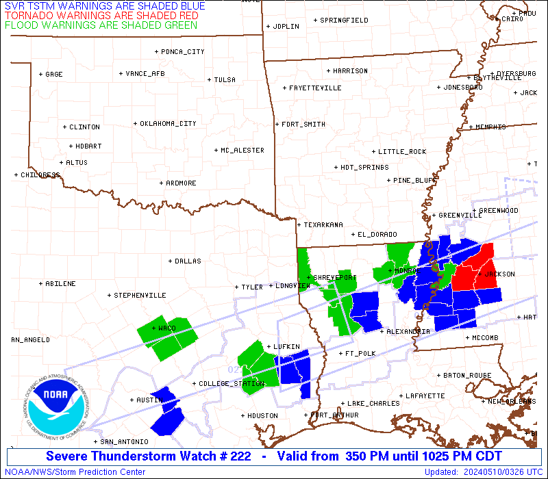
Severe Thunderstorm Watch Number 222
NWS Storm Prediction Center Norman OK
350 PM CDT Thu May 9 2024
The NWS Storm Prediction Center has issued a
* Severe Thunderstorm Watch for portions of
Southern Arkansas
Northern Louisiana
Southeast Oklahoma
Northeast Texas
* Effective this Thursday afternoon and evening from 350 PM until
1100 PM CDT.
* Primary threats include...
Scattered large hail likely with isolated very large hail events
to 2.5 inches in diameter possible
Scattered damaging wind gusts to 70 mph likely
A tornado or two possible
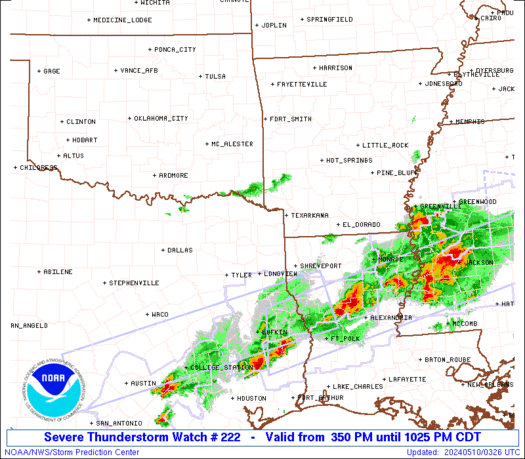
SUMMARY...Clusters of supercells and eventual linear segments,
including the possibility for bows, will gradually move west to east
across the Watch area late this afternoon through the evening.
Large to very large hail and severe gusts will be possible through
at least the early evening, before upscale growth and the risk for
wind damage and perhaps a tornado or two accompanies linear storm
modes.
The severe thunderstorm watch area is approximately along and 80
statute miles north and south of a line from 40 miles south of
Durant OK to 45 miles north of Monroe LA. For a complete depiction
of the watch see the associated watch outline update (WOUS64 KWNS
WOU2).
PRECAUTIONARY/PREPAREDNESS ACTIONS...
REMEMBER...A Severe Thunderstorm Watch means conditions are
favorable for severe thunderstorms in and close to the watch area.
Persons in these areas should be on the lookout for threatening
weather conditions and listen for later statements and possible
warnings. Severe thunderstorms can and occasionally do produce
tornadoes.
&&
OTHER WATCH INFORMATION...CONTINUE...WW 218...WW 219...WW
220...WW 221...
AVIATION...A few severe thunderstorms with hail surface and aloft to
2.5 inches. Extreme turbulence and surface wind gusts to 60 knots. A
few cumulonimbi with maximum tops to 500. Mean storm motion vector
27035.
...Smith

   SEL2

   URGENT - IMMEDIATE BROADCAST REQUESTED
   Severe Thunderstorm Watch Number 222
   NWS Storm Prediction Center Norman OK
   350 PM CDT Thu May 9 2024

   The NWS Storm Prediction Center has issued a

   * Severe Thunderstorm Watch for portions of
     Southern Arkansas
     Northern Louisiana
     Southeast Oklahoma
     Northeast Texas

   * Effective this Thursday afternoon and evening from 350 PM until
     1100 PM CDT.

   * Primary threats include...
     Scattered large hail likely with isolated very large hail events
       to 2.5 inches in diameter possible
     Scattered damaging wind gusts to 70 mph likely
     A tornado or two possible

   SUMMARY...Clusters of supercells and eventual linear segments,
   including the possibility for bows, will gradually move west to east
   across the Watch area late this afternoon through the evening.
   Large to very large hail and severe gusts will be possible through
   at least the early evening, before upscale growth and the risk for
   wind damage and perhaps a tornado or two accompanies linear storm
   modes.

   The severe thunderstorm watch area is approximately along and 80
   statute miles north and south of a line from 40 miles south of
   Durant OK to 45 miles north of Monroe LA. For a complete depiction
   of the watch see the associated watch outline update (WOUS64 KWNS
   WOU2).

   PRECAUTIONARY/PREPAREDNESS ACTIONS...

   REMEMBER...A Severe Thunderstorm Watch means conditions are
   favorable for severe thunderstorms in and close to the watch area.
   Persons in these areas should be on the lookout for threatening
   weather conditions and listen for later statements and possible
   warnings. Severe thunderstorms can and occasionally do produce
   tornadoes.

   &&

   OTHER WATCH INFORMATION...CONTINUE...WW 218...WW 219...WW
   220...WW 221...

   AVIATION...A few severe thunderstorms with hail surface and aloft to
   2.5 inches. Extreme turbulence and surface wind gusts to 60 knots. A
   few cumulonimbi with maximum tops to 500. Mean storm motion vector
   27035.

   ...Smith
 Note:
The Aviation Watch (SAW) product is an approximation to the watch area.
The actual watch is depicted by the shaded areas.
Note:
The Aviation Watch (SAW) product is an approximation to the watch area.
The actual watch is depicted by the shaded areas.
   SAW2
   WW 222 SEVERE TSTM AR LA OK TX 092050Z - 100400Z
   AXIS..80 STATUTE MILES NORTH AND SOUTH OF LINE..
   40S DUA/DURANT OK/ - 45N MLU/MONROE LA/
   ..AVIATION COORDS.. 70NM N/S /44NE TTT - 36E ELD/
   HAIL SURFACE AND ALOFT..2.5 INCHES. WIND GUSTS..60 KNOTS.
   MAX TOPS TO 500. MEAN STORM MOTION VECTOR 27035.

   LAT...LON 34539640 34339203 32009203 32219640

   THIS IS AN APPROXIMATION TO THE WATCH AREA.  FOR A
   COMPLETE DEPICTION OF THE WATCH SEE WOUS64 KWNS
   FOR WOU2.
Watch 222 Status Report Messages:
STATUS REPORT #6 ON WW 222

VALID 100200Z - 100400Z

SEVERE WEATHER THREAT CONTINUES RIGHT OF A LINE FROM 35 S SHV TO
45 E SHV TO 20 NE MLU.

WW 222 WILL BE ALLOWED TO EXPIRE AT 100400Z.

..SQUITIERI..05/10/24

ATTN...WFO...LZK...SHV...TSA...FWD...

&&

STATUS REPORT FOR WS 222

SEVERE WEATHER THREAT CONTINUES FOR THE FOLLOWING AREAS

LAC013-049-073-100400-

LA
.    LOUISIANA PARISHES INCLUDED ARE

BIENVILLE	     JACKSON		 OUACHITA
$$


THE WATCH STATUS MESSAGE IS FOR GUIDANCE PURPOSES ONLY.  PLEASE
REFER TO WATCH COUNTY NOTIFICATION STATEMENTS FOR OFFICIAL
INFORMATION ON COUNTIES...INDEPENDENT CITIES AND MARINE ZONES
CLEARED FROM SEVERE THUNDERSTORM AND TORNADO WATCHES.
$$

STATUS REPORT #5 ON WW 222

VALID 100110Z - 100240Z

SEVERE WEATHER THREAT CONTINUES RIGHT OF A LINE FROM 30 SE GGG TO
15 NW SHV TO 35 SSW LLQ.

FOR ADDITIONAL INFORMATION SEE MESOSCALE DISCUSSION 738

..SQUITIERI..05/10/24

ATTN...WFO...LZK...SHV...TSA...FWD...

&&

STATUS REPORT FOR WS 222

SEVERE WEATHER THREAT CONTINUES FOR THE FOLLOWING AREAS

LAC013-015-017-027-049-061-073-111-119-100240-

LA
.    LOUISIANA PARISHES INCLUDED ARE

BIENVILLE	     BOSSIER		 CADDO
CLAIBORNE	     JACKSON		 LINCOLN
OUACHITA	     UNION		 WEBSTER
$$


THE WATCH STATUS MESSAGE IS FOR GUIDANCE PURPOSES ONLY.  PLEASE
REFER TO WATCH COUNTY NOTIFICATION STATEMENTS FOR OFFICIAL
INFORMATION ON COUNTIES...INDEPENDENT CITIES AND MARINE ZONES
CLEARED FROM SEVERE THUNDERSTORM AND TORNADO WATCHES.
$$

STATUS REPORT #4 ON WW 222

VALID 100015Z - 100140Z

SEVERE WEATHER THREAT CONTINUES RIGHT OF A LINE FROM 20 NNW CRS
TO 30 NNW GGG TO 20 SE TXK TO 5 SSE LLQ.

..SQUITIERI..05/10/24

ATTN...WFO...LZK...SHV...TSA...FWD...

&&

STATUS REPORT FOR WS 222

SEVERE WEATHER THREAT CONTINUES FOR THE FOLLOWING AREAS

ARC011-027-073-139-100140-

AR
.    ARKANSAS COUNTIES INCLUDED ARE

BRADLEY 	     COLUMBIA		 LAFAYETTE
UNION
$$


LAC013-015-017-027-049-061-073-111-119-100140-

LA
.    LOUISIANA PARISHES INCLUDED ARE

BIENVILLE	     BOSSIER		 CADDO
CLAIBORNE	     JACKSON		 LINCOLN
OUACHITA	     UNION		 WEBSTER
$$


TXC183-203-315-423-459-100140-

TX
.    TEXAS COUNTIES INCLUDED ARE

GREGG		     HARRISON		 MARION
SMITH		     UPSHUR
$$


THE WATCH STATUS MESSAGE IS FOR GUIDANCE PURPOSES ONLY.  PLEASE
REFER TO WATCH COUNTY NOTIFICATION STATEMENTS FOR OFFICIAL
INFORMATION ON COUNTIES...INDEPENDENT CITIES AND MARINE ZONES
CLEARED FROM SEVERE THUNDERSTORM AND TORNADO WATCHES.
$$

STATUS REPORT #3 ON WW 222

VALID 092300Z - 100040Z

SEVERE WEATHER THREAT CONTINUES RIGHT OF A LINE FROM 10 WSW DUA
TO 25 SSW DEQ TO 25 E HOT.

..SQUITIERI..05/09/24

ATTN...WFO...LZK...SHV...TSA...FWD...

&&

STATUS REPORT FOR WS 222

SEVERE WEATHER THREAT CONTINUES FOR THE FOLLOWING AREAS

ARC011-013-019-025-027-039-057-073-081-091-099-103-139-100040-

AR
.    ARKANSAS COUNTIES INCLUDED ARE

BRADLEY 	     CALHOUN		 CLARK
CLEVELAND	     COLUMBIA		 DALLAS
HEMPSTEAD	     LAFAYETTE		 LITTLE RIVER
MILLER		     NEVADA		 OUACHITA
UNION
$$


LAC013-015-017-027-049-061-073-111-119-100040-

LA
.    LOUISIANA PARISHES INCLUDED ARE

BIENVILLE	     BOSSIER		 CADDO
CLAIBORNE	     JACKSON		 LINCOLN
OUACHITA	     UNION		 WEBSTER
$$


TXC037-063-067-119-159-183-203-223-231-257-277-315-343-379-387-
397-423-449-459-467-499-100040-

TX
.    TEXAS COUNTIES INCLUDED ARE

BOWIE		     CAMP		 CASS
DELTA		     FRANKLIN		 GREGG
HARRISON	     HOPKINS		 HUNT
KAUFMAN 	     LAMAR		 MARION
MORRIS		     RAINS		 RED RIVER
ROCKWALL	     SMITH		 TITUS
UPSHUR		     VAN ZANDT		 WOOD
$$


THE WATCH STATUS MESSAGE IS FOR GUIDANCE PURPOSES ONLY.  PLEASE
REFER TO WATCH COUNTY NOTIFICATION STATEMENTS FOR OFFICIAL
INFORMATION ON COUNTIES...INDEPENDENT CITIES AND MARINE ZONES
CLEARED FROM SEVERE THUNDERSTORM AND TORNADO WATCHES.
$$

STATUS REPORT #2 ON WW 222

VALID 092150Z - 092240Z

THE SEVERE WEATHER THREAT CONTINUES ACROSS THE ENTIRE WATCH AREA.

..BENTLEY..05/09/24

ATTN...WFO...LZK...SHV...TSA...FWD...

&&

STATUS REPORT FOR WS 222

SEVERE WEATHER THREAT CONTINUES FOR THE FOLLOWING AREAS

ARC011-013-019-025-027-039-057-061-073-081-091-099-103-109-133-
139-092240-

AR
.    ARKANSAS COUNTIES INCLUDED ARE

BRADLEY 	     CALHOUN		 CLARK
CLEVELAND	     COLUMBIA		 DALLAS
HEMPSTEAD	     HOWARD		 LAFAYETTE
LITTLE RIVER	     MILLER		 NEVADA
OUACHITA	     PIKE		 SEVIER
UNION
$$


LAC013-015-017-027-049-061-073-111-119-092240-

LA
.    LOUISIANA PARISHES INCLUDED ARE

BIENVILLE	     BOSSIER		 CADDO
CLAIBORNE	     JACKSON		 LINCOLN
OUACHITA	     UNION		 WEBSTER
$$


OKC023-089-127-092240-

OK
.    OKLAHOMA COUNTIES INCLUDED ARE

CHOCTAW 	     MCCURTAIN		 PUSHMATAHA
$$


TXC037-063-067-119-159-183-203-223-231-257-277-315-343-379-387-
397-423-449-459-467-499-092240-

TX
.    TEXAS COUNTIES INCLUDED ARE

BOWIE		     CAMP		 CASS
DELTA		     FRANKLIN		 GREGG
HARRISON	     HOPKINS		 HUNT
KAUFMAN 	     LAMAR		 MARION
MORRIS		     RAINS		 RED RIVER
ROCKWALL	     SMITH		 TITUS
UPSHUR		     VAN ZANDT		 WOOD
$$


THE WATCH STATUS MESSAGE IS FOR GUIDANCE PURPOSES ONLY.  PLEASE
REFER TO WATCH COUNTY NOTIFICATION STATEMENTS FOR OFFICIAL
INFORMATION ON COUNTIES...INDEPENDENT CITIES AND MARINE ZONES
CLEARED FROM SEVERE THUNDERSTORM AND TORNADO WATCHES.
$$

STATUS REPORT #1 ON WW 222

VALID 092120Z - 092240Z

THE SEVERE WEATHER THREAT CONTINUES ACROSS THE ENTIRE WATCH AREA.

..BENTLEY..05/09/24

ATTN...WFO...LZK...SHV...TSA...FWD...

&&

STATUS REPORT FOR WS 222

SEVERE WEATHER THREAT CONTINUES FOR THE FOLLOWING AREAS

ARC011-013-019-025-027-039-057-061-073-081-091-099-103-109-133-
139-092240-

AR
.    ARKANSAS COUNTIES INCLUDED ARE

BRADLEY 	     CALHOUN		 CLARK
CLEVELAND	     COLUMBIA		 DALLAS
HEMPSTEAD	     HOWARD		 LAFAYETTE
LITTLE RIVER	     MILLER		 NEVADA
OUACHITA	     PIKE		 SEVIER
UNION
$$


LAC013-015-017-027-049-061-073-111-119-092240-

LA
.    LOUISIANA PARISHES INCLUDED ARE

BIENVILLE	     BOSSIER		 CADDO
CLAIBORNE	     JACKSON		 LINCOLN
OUACHITA	     UNION		 WEBSTER
$$


OKC023-089-127-092240-

OK
.    OKLAHOMA COUNTIES INCLUDED ARE

CHOCTAW 	     MCCURTAIN		 PUSHMATAHA
$$


TXC037-063-067-119-159-183-203-223-231-257-277-315-343-379-387-
397-423-449-459-467-499-092240-

TX
.    TEXAS COUNTIES INCLUDED ARE

BOWIE		     CAMP		 CASS
DELTA		     FRANKLIN		 GREGG
HARRISON	     HOPKINS		 HUNT
KAUFMAN 	     LAMAR		 MARION
MORRIS		     RAINS		 RED RIVER
ROCKWALL	     SMITH		 TITUS
UPSHUR		     VAN ZANDT		 WOOD
$$


THE WATCH STATUS MESSAGE IS FOR GUIDANCE PURPOSES ONLY.  PLEASE
REFER TO WATCH COUNTY NOTIFICATION STATEMENTS FOR OFFICIAL
INFORMATION ON COUNTIES...INDEPENDENT CITIES AND MARINE ZONES
CLEARED FROM SEVERE THUNDERSTORM AND TORNADO WATCHES.
$$
Note:
Click for Complete Product Text.
Tornadoes
Probability of 2 or more tornadoes
|
Low (20%)
|
Probability of 1 or more strong (EF2-EF5) tornadoes
|
Low (5%)
|
Wind
Probability of 10 or more severe wind events
|
High (70%)
|
Probability of 1 or more wind events > 65 knots
|
Low (20%)
|
Hail
Probability of 10 or more severe hail events
|
Mod (60%)
|
Probability of 1 or more hailstones > 2 inches
|
Mod (50%)
|
Combined Severe Hail/Wind
Probability of 6 or more combined severe hail/wind events
|
High (>95%)
|
For each watch, probabilities for particular events inside the watch
(listed above in each table) are determined by the issuing forecaster.
The "Low" category contains probability values ranging from less than 2%
to 20% (EF2-EF5 tornadoes), less than 5% to 20% (all other probabilities),
"Moderate" from 30% to 60%, and "High" from 70% to greater than 95%.
High values are bolded and lighter in color to provide awareness of
an increased threat for a particular event.


 @NWSSPC