Note:
The expiration time in the watch graphic is amended if the watch is
replaced, cancelled or extended.
Note:
Note:
The expiration time in the watch graphic is amended if the watch is
replaced, cancelled or extended.
Note: Click for
Watch Status Reports.
SEL6
URGENT - IMMEDIATE BROADCAST REQUESTED
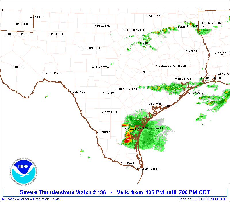
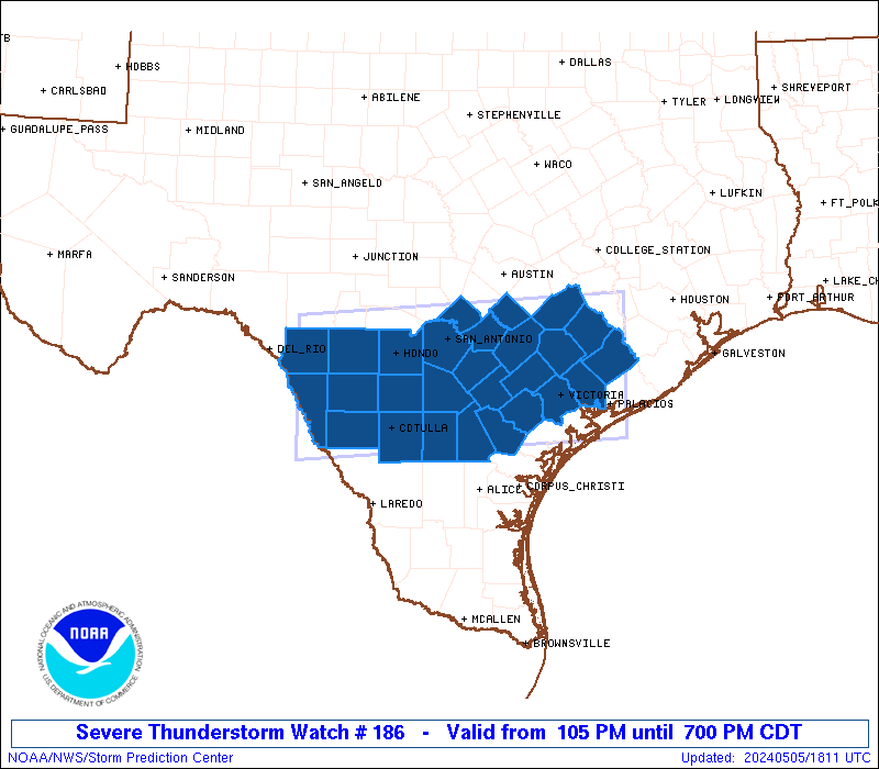
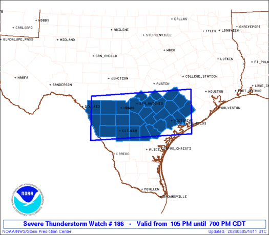
Severe Thunderstorm Watch Number 186
NWS Storm Prediction Center Norman OK
105 PM CDT Sun May 5 2024
The NWS Storm Prediction Center has issued a
* Severe Thunderstorm Watch for portions of
South-central Texas
* Effective this Sunday afternoon and evening from 105 PM until
700 PM CDT.
* Primary threats include...
Scattered large hail and isolated very large hail events to 2.5
inches in diameter likely
Scattered damaging wind gusts to 70 mph likely
A tornado or two possible
SUMMARY...Scattered thunderstorms will likely continue to develop
through the early and mid afternoon across the Watch area. Ample
high-level flow and a moist and unstable airmass will support
organized storms, including supercells and multicells. Large to
very large hail and severe gusts will be the primary hazards.
The severe thunderstorm watch area is approximately along and 60
statute miles north and south of a line from 85 miles west northwest
of Cotulla TX to 35 miles north northeast of Palacios TX. For a
complete depiction of the watch see the associated watch outline
update (WOUS64 KWNS WOU6).
PRECAUTIONARY/PREPAREDNESS ACTIONS...
REMEMBER...A Severe Thunderstorm Watch means conditions are
favorable for severe thunderstorms in and close to the watch area.
Persons in these areas should be on the lookout for threatening
weather conditions and listen for later statements and possible
warnings. Severe thunderstorms can and occasionally do produce
tornadoes.
&&
AVIATION...A few severe thunderstorms with hail surface and aloft to
2.5 inches. Extreme turbulence and surface wind gusts to 60 knots. A
few cumulonimbi with maximum tops to 500. Mean storm motion vector
27025.
...Smith

   SEL6

   URGENT - IMMEDIATE BROADCAST REQUESTED
   Severe Thunderstorm Watch Number 186
   NWS Storm Prediction Center Norman OK
   105 PM CDT Sun May 5 2024

   The NWS Storm Prediction Center has issued a

   * Severe Thunderstorm Watch for portions of
     South-central Texas

   * Effective this Sunday afternoon and evening from 105 PM until
     700 PM CDT.

   * Primary threats include...
     Scattered large hail and isolated very large hail events to 2.5
       inches in diameter likely
     Scattered damaging wind gusts to 70 mph likely
     A tornado or two possible

   SUMMARY...Scattered thunderstorms will likely continue to develop
   through the early and mid afternoon across the Watch area.  Ample
   high-level flow and a moist and unstable airmass will support
   organized storms, including supercells and multicells.  Large to
   very large hail and severe gusts will be the primary hazards.

   The severe thunderstorm watch area is approximately along and 60
   statute miles north and south of a line from 85 miles west northwest
   of Cotulla TX to 35 miles north northeast of Palacios TX. For a
   complete depiction of the watch see the associated watch outline
   update (WOUS64 KWNS WOU6).

   PRECAUTIONARY/PREPAREDNESS ACTIONS...

   REMEMBER...A Severe Thunderstorm Watch means conditions are
   favorable for severe thunderstorms in and close to the watch area.
   Persons in these areas should be on the lookout for threatening
   weather conditions and listen for later statements and possible
   warnings. Severe thunderstorms can and occasionally do produce
   tornadoes.

   &&

   AVIATION...A few severe thunderstorms with hail surface and aloft to
   2.5 inches. Extreme turbulence and surface wind gusts to 60 knots. A
   few cumulonimbi with maximum tops to 500. Mean storm motion vector
   27025.

   ...Smith
 Note:
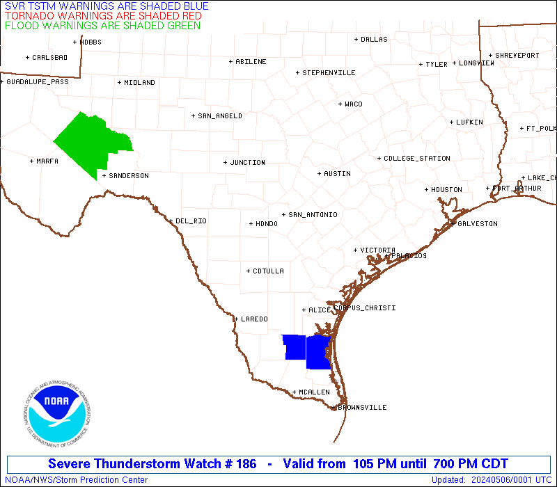
The Aviation Watch (SAW) product is an approximation to the watch area.
The actual watch is depicted by the shaded areas.
Note:
The Aviation Watch (SAW) product is an approximation to the watch area.
The actual watch is depicted by the shaded areas.
   SAW6
   WW 186 SEVERE TSTM TX 051805Z - 060000Z
   AXIS..60 STATUTE MILES NORTH AND SOUTH OF LINE..
   85WNW COT/COTULLA TX/ - 35NNE PSX/PALACIOS TX/
   ..AVIATION COORDS.. 50NM N/S /30SSE DLF - 30NNE PSX/
   HAIL SURFACE AND ALOFT..2.5 INCHES. WIND GUSTS..60 KNOTS.
   MAX TOPS TO 500. MEAN STORM MOTION VECTOR 27025.

   LAT...LON 29780052 30079603 28339603 28050052

   THIS IS AN APPROXIMATION TO THE WATCH AREA.  FOR A
   COMPLETE DEPICTION OF THE WATCH SEE WOUS64 KWNS
   FOR WOU6.
Watch 186 Status Report Messages:
STATUS REPORT #3 ON WW 186
VALID 052320Z - 060040Z
SEVERE WEATHER THREAT CONTINUES RIGHT OF A LINE FROM 45 NW ALI TO
35 W NIR TO 15 SSE NIR.
..GOSS..05/05/24
ATTN...WFO...EWX...CRP...HGX...
&&
STATUS REPORT FOR WS 186
SEVERE WEATHER THREAT CONTINUES FOR THE FOLLOWING AREAS
TXC025-089-131-249-273-297-355-409-060040-
TX
. TEXAS COUNTIES INCLUDED ARE
BEE COLORADO DUVAL
JIM WELLS KLEBERG LIVE OAK
NUECES SAN PATRICIO
$$
GMZ231-232-250-270-060040-
CW
. ADJACENT COASTAL WATERS INCLUDED ARE
GMZ231
GMZ232
GMZ250
GMZ270
$$
THE WATCH STATUS MESSAGE IS FOR GUIDANCE PURPOSES ONLY. PLEASE
REFER TO WATCH COUNTY NOTIFICATION STATEMENTS FOR OFFICIAL
INFORMATION ON COUNTIES...INDEPENDENT CITIES AND MARINE ZONES
CLEARED FROM SEVERE THUNDERSTORM AND TORNADO WATCHES.
$$
STATUS REPORT #2 ON WW 186
VALID 052040Z - 052140Z
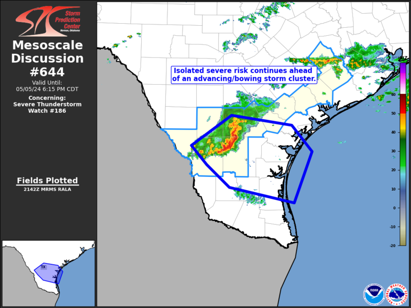
THE SEVERE WEATHER THREAT CONTINUES ACROSS THE ENTIRE WATCH AREA.
FOR ADDITIONAL INFORMATION SEE MESOSCALE DISCUSSION 642.
..GRAMS..05/05/24
ATTN...WFO...EWX...CRP...HGX...
&&
STATUS REPORT FOR WS 186
SEVERE WEATHER THREAT CONTINUES FOR THE FOLLOWING AREAS
TXC013-025-029-055-089-091-123-127-131-149-163-175-177-187-239-
255-271-283-285-297-311-323-325-463-469-479-481-493-507-
052140-
TX
. TEXAS COUNTIES INCLUDED ARE
ATASCOSA BEE BEXAR
CALDWELL COLORADO COMAL
DEWITT DIMMIT DUVAL
FAYETTE FRIO GOLIAD
GONZALES GUADALUPE JACKSON
KARNES KINNEY LA SALLE
LAVACA LIVE OAK MCMULLEN
MAVERICK MEDINA UVALDE
VICTORIA WEBB WHARTON
WILSON ZAVALA
$$
THE WATCH STATUS MESSAGE IS FOR GUIDANCE PURPOSES ONLY. PLEASE
REFER TO WATCH COUNTY NOTIFICATION STATEMENTS FOR OFFICIAL
INFORMATION ON COUNTIES...INDEPENDENT CITIES AND MARINE ZONES
CLEARED FROM SEVERE THUNDERSTORM AND TORNADO WATCHES.
$$
STATUS REPORT #1 ON WW 186
VALID 051935Z - 052040Z
THE SEVERE WEATHER THREAT CONTINUES ACROSS THE ENTIRE WATCH AREA.
..GRAMS..05/05/24
ATTN...WFO...EWX...CRP...HGX...
&&
STATUS REPORT FOR WS 186
SEVERE WEATHER THREAT CONTINUES FOR THE FOLLOWING AREAS
TXC013-025-029-055-089-091-123-127-149-163-175-177-187-239-255-
271-283-285-297-311-323-325-463-469-481-493-507-052040-
TX
. TEXAS COUNTIES INCLUDED ARE
ATASCOSA BEE BEXAR
CALDWELL COLORADO COMAL
DEWITT DIMMIT FAYETTE
FRIO GOLIAD GONZALES
GUADALUPE JACKSON KARNES
KINNEY LA SALLE LAVACA
LIVE OAK MCMULLEN MAVERICK
MEDINA UVALDE VICTORIA
WHARTON WILSON ZAVALA
$$
THE WATCH STATUS MESSAGE IS FOR GUIDANCE PURPOSES ONLY. PLEASE
REFER TO WATCH COUNTY NOTIFICATION STATEMENTS FOR OFFICIAL
INFORMATION ON COUNTIES...INDEPENDENT CITIES AND MARINE ZONES
CLEARED FROM SEVERE THUNDERSTORM AND TORNADO WATCHES.
$$
Note:
Click for Complete Product Text.
Tornadoes
Probability of 2 or more tornadoes
|
Low (20%)
|
Probability of 1 or more strong (EF2-EF5) tornadoes
|
Low (5%)
|
Wind
Probability of 10 or more severe wind events
|
Mod (60%)
|
Probability of 1 or more wind events > 65 knots
|
Low (20%)
|
Hail
Probability of 10 or more severe hail events
|
Mod (60%)
|
Probability of 1 or more hailstones > 2 inches
|
Mod (60%)
|
Combined Severe Hail/Wind
Probability of 6 or more combined severe hail/wind events
|
High (>95%)
|
For each watch, probabilities for particular events inside the watch
(listed above in each table) are determined by the issuing forecaster.
The "Low" category contains probability values ranging from less than 2%
to 20% (EF2-EF5 tornadoes), less than 5% to 20% (all other probabilities),
"Moderate" from 30% to 60%, and "High" from 70% to greater than 95%.
High values are bolded and lighter in color to provide awareness of
an increased threat for a particular event.


 @NWSSPC