 Note:
The expiration time in the watch graphic is amended if the watch is
replaced, cancelled or extended.
Note:
Note:
The expiration time in the watch graphic is amended if the watch is
replaced, cancelled or extended.
Note: Click for
Watch Status Reports.
SEL3
URGENT - IMMEDIATE BROADCAST REQUESTED
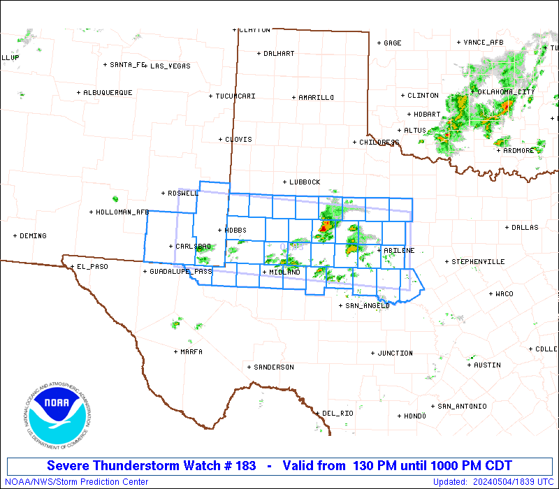
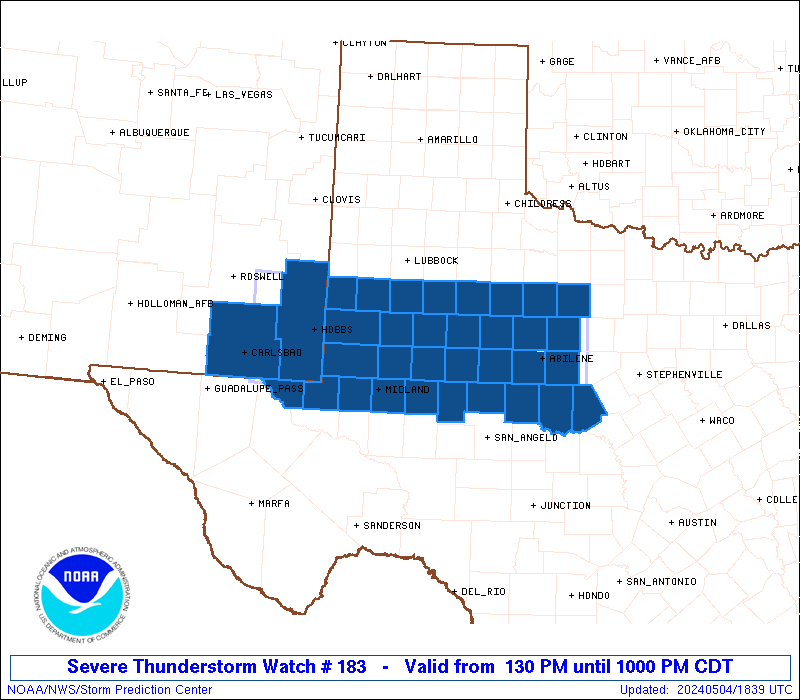
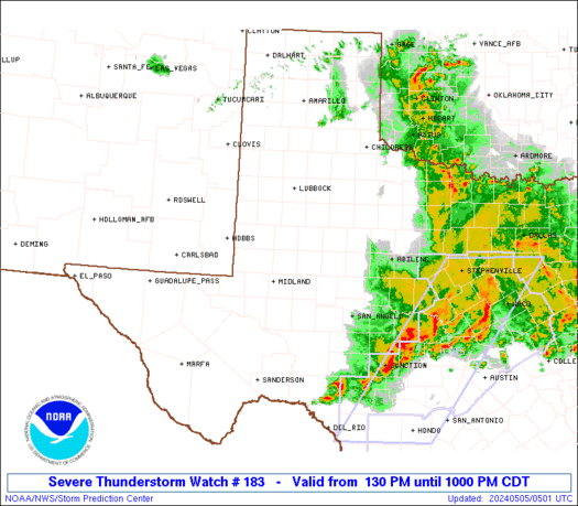
Severe Thunderstorm Watch Number 183
NWS Storm Prediction Center Norman OK
130 PM CDT Sat May 4 2024
The NWS Storm Prediction Center has issued a
* Severe Thunderstorm Watch for portions of
Southeast New Mexico
West into Northwest Texas
* Effective this Saturday afternoon and evening from 130 PM until
1000 PM CDT.
* Primary threats include...
Widespread large hail and isolated very large hail events to 3
inches in diameter likely
Scattered damaging wind gusts to 70 mph possible
A tornado or two possible
SUMMARY...Scattered severe thunderstorms are forecast to develop
this afternoon across portions of the Permian Basin east into the
Texas Big Country. Elevated supercells will likely pose a large to
very large hail risk. In closer proximity to the surface boundary,
a risk for severe gusts and perhaps a tornado may develop later
today into the early evening.
The severe thunderstorm watch area is approximately along and 50
statute miles north and south of a line from 55 miles west of Hobbs
NM to 40 miles east of Abilene TX. For a complete depiction of the
watch see the associated watch outline update (WOUS64 KWNS WOU3).
PRECAUTIONARY/PREPAREDNESS ACTIONS...
REMEMBER...A Severe Thunderstorm Watch means conditions are
favorable for severe thunderstorms in and close to the watch area.
Persons in these areas should be on the lookout for threatening
weather conditions and listen for later statements and possible
warnings. Severe thunderstorms can and occasionally do produce
tornadoes.
&&
AVIATION...A few severe thunderstorms with hail surface and aloft to
3 inches. Extreme turbulence and surface wind gusts to 60 knots. A
few cumulonimbi with maximum tops to 500. Mean storm motion vector
26025.
...Smith

   SEL3

   URGENT - IMMEDIATE BROADCAST REQUESTED
   Severe Thunderstorm Watch Number 183
   NWS Storm Prediction Center Norman OK
   130 PM CDT Sat May 4 2024

   The NWS Storm Prediction Center has issued a

   * Severe Thunderstorm Watch for portions of
     Southeast New Mexico
     West into Northwest Texas

   * Effective this Saturday afternoon and evening from 130 PM until
     1000 PM CDT.

   * Primary threats include...
     Widespread large hail and isolated very large hail events to 3
       inches in diameter likely
     Scattered damaging wind gusts to 70 mph possible
     A tornado or two possible

   SUMMARY...Scattered severe thunderstorms are forecast to develop
   this afternoon across portions of the Permian Basin east into the
   Texas Big Country.  Elevated supercells will likely pose a large to
   very large hail risk.  In closer proximity to the surface boundary,
   a risk for severe gusts and perhaps a tornado may develop later
   today into the early evening.

   The severe thunderstorm watch area is approximately along and 50
   statute miles north and south of a line from 55 miles west of Hobbs
   NM to 40 miles east of Abilene TX. For a complete depiction of the
   watch see the associated watch outline update (WOUS64 KWNS WOU3).

   PRECAUTIONARY/PREPAREDNESS ACTIONS...

   REMEMBER...A Severe Thunderstorm Watch means conditions are
   favorable for severe thunderstorms in and close to the watch area.
   Persons in these areas should be on the lookout for threatening
   weather conditions and listen for later statements and possible
   warnings. Severe thunderstorms can and occasionally do produce
   tornadoes.

   &&

   AVIATION...A few severe thunderstorms with hail surface and aloft to
   3 inches. Extreme turbulence and surface wind gusts to 60 knots. A
   few cumulonimbi with maximum tops to 500. Mean storm motion vector
   26025.

   ...Smith
 Note:
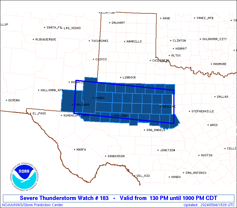
The Aviation Watch (SAW) product is an approximation to the watch area.
The actual watch is depicted by the shaded areas.
Note:
The Aviation Watch (SAW) product is an approximation to the watch area.
The actual watch is depicted by the shaded areas.
   SAW3
   WW 183 SEVERE TSTM NM TX 041830Z - 050300Z
   AXIS..50 STATUTE MILES NORTH AND SOUTH OF LINE..
   55W HOB/HOBBS NM/ - 40E ABI/ABILENE TX/
   ..AVIATION COORDS.. 45NM N/S /46SSE CME - 44E ABI/
   HAIL SURFACE AND ALOFT..3 INCHES. WIND GUSTS..60 KNOTS.
   MAX TOPS TO 500. MEAN STORM MOTION VECTOR 26025.

   LAT...LON 33400417 33149899 31699899 31950417

   THIS IS AN APPROXIMATION TO THE WATCH AREA.  FOR A
   COMPLETE DEPICTION OF THE WATCH SEE WOUS64 KWNS
   FOR WOU3.
Watch 183 Status Report Messages:
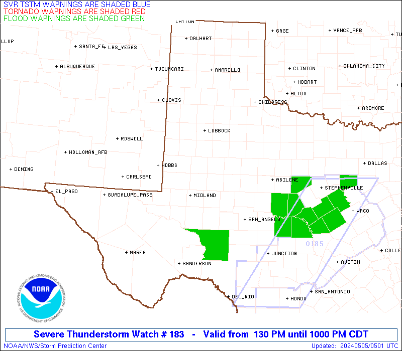
STATUS REPORT #6 ON WW 183

VALID 050240Z - 050340Z

SEVERE WEATHER THREAT CONTINUES RIGHT OF A LINE FROM 45 SSE MAF
TO 40 ESE BGS TO 35 NW ABI TO 55 NNW ABI TO 60 E LBB.

..FLOURNOY..05/05/24

ATTN...WFO...MAF...SJT...LUB...

&&

STATUS REPORT FOR WS 183

SEVERE WEATHER THREAT CONTINUES FOR THE FOLLOWING AREAS

TXC049-059-081-083-207-253-353-399-417-441-447-050340-

TX
.    TEXAS COUNTIES INCLUDED ARE

BROWN		     CALLAHAN		 COKE
COLEMAN 	     HASKELL		 JONES
NOLAN		     RUNNELS		 SHACKELFORD
TAYLOR		     THROCKMORTON
$$


THE WATCH STATUS MESSAGE IS FOR GUIDANCE PURPOSES ONLY.  PLEASE
REFER TO WATCH COUNTY NOTIFICATION STATEMENTS FOR OFFICIAL
INFORMATION ON COUNTIES...INDEPENDENT CITIES AND MARINE ZONES
CLEARED FROM SEVERE THUNDERSTORM AND TORNADO WATCHES.
$$

STATUS REPORT #5 ON WW 183

VALID 050110Z - 050240Z

SEVERE WEATHER THREAT CONTINUES RIGHT OF A LINE FROM 25 ESE MAF
TO 15 ESE BGS TO 35 NE BGS TO 55 NNE BGS TO 15 S LBB.

..FLOURNOY..05/05/24

ATTN...WFO...MAF...SJT...LUB...

&&

STATUS REPORT FOR WS 183

SEVERE WEATHER THREAT CONTINUES FOR THE FOLLOWING AREAS

TXC049-059-081-083-151-169-173-207-253-263-335-353-399-415-417-
431-433-441-447-050240-

TX
.    TEXAS COUNTIES INCLUDED ARE

BROWN		     CALLAHAN		 COKE
COLEMAN 	     FISHER		 GARZA
GLASSCOCK	     HASKELL		 JONES
KENT		     MITCHELL		 NOLAN
RUNNELS 	     SCURRY		 SHACKELFORD
STERLING	     STONEWALL		 TAYLOR
THROCKMORTON
$$


THE WATCH STATUS MESSAGE IS FOR GUIDANCE PURPOSES ONLY.  PLEASE
REFER TO WATCH COUNTY NOTIFICATION STATEMENTS FOR OFFICIAL
INFORMATION ON COUNTIES...INDEPENDENT CITIES AND MARINE ZONES
CLEARED FROM SEVERE THUNDERSTORM AND TORNADO WATCHES.
$$

STATUS REPORT #4 ON WW 183

VALID 050010Z - 050140Z

THE SEVERE WEATHER THREAT CONTINUES ACROSS THE ENTIRE WATCH AREA.

..FLOURNOY..05/05/24

ATTN...WFO...MAF...SJT...LUB...

&&

STATUS REPORT FOR WS 183

SEVERE WEATHER THREAT CONTINUES FOR THE FOLLOWING AREAS

NMC015-025-050140-

NM
.    NEW MEXICO COUNTIES INCLUDED ARE

EDDY		     LEA
$$


TXC003-033-049-059-081-083-115-135-151-165-169-173-207-227-253-
263-301-305-317-329-335-353-399-415-417-431-433-441-445-447-495-
501-050140-

TX
.    TEXAS COUNTIES INCLUDED ARE

ANDREWS 	     BORDEN		 BROWN
CALLAHAN	     COKE		 COLEMAN
DAWSON		     ECTOR		 FISHER
GAINES		     GARZA		 GLASSCOCK
HASKELL 	     HOWARD		 JONES
KENT		     LOVING		 LYNN
MARTIN		     MIDLAND		 MITCHELL
NOLAN		     RUNNELS		 SCURRY
SHACKELFORD	     STERLING		 STONEWALL
TAYLOR		     TERRY		 THROCKMORTON
WINKLER 	     YOAKUM
$$


THE WATCH STATUS MESSAGE IS FOR GUIDANCE PURPOSES ONLY.  PLEASE
REFER TO WATCH COUNTY NOTIFICATION STATEMENTS FOR OFFICIAL
INFORMATION ON COUNTIES...INDEPENDENT CITIES AND MARINE ZONES
CLEARED FROM SEVERE THUNDERSTORM AND TORNADO WATCHES.
$$

STATUS REPORT #3 ON WW 183

VALID 042305Z - 050040Z

THE SEVERE WEATHER THREAT CONTINUES ACROSS THE ENTIRE WATCH AREA.

..FLOURNOY..05/04/24

ATTN...WFO...MAF...SJT...LUB...

&&

STATUS REPORT FOR WS 183

SEVERE WEATHER THREAT CONTINUES FOR THE FOLLOWING AREAS

NMC015-025-050040-

NM
.    NEW MEXICO COUNTIES INCLUDED ARE

EDDY		     LEA
$$


TXC003-033-049-059-081-083-115-135-151-165-169-173-207-227-253-
263-301-305-317-329-335-353-399-415-417-431-433-441-445-447-495-
501-050040-

TX
.    TEXAS COUNTIES INCLUDED ARE

ANDREWS 	     BORDEN		 BROWN
CALLAHAN	     COKE		 COLEMAN
DAWSON		     ECTOR		 FISHER
GAINES		     GARZA		 GLASSCOCK
HASKELL 	     HOWARD		 JONES
KENT		     LOVING		 LYNN
MARTIN		     MIDLAND		 MITCHELL
NOLAN		     RUNNELS		 SCURRY
SHACKELFORD	     STERLING		 STONEWALL
TAYLOR		     TERRY		 THROCKMORTON
WINKLER 	     YOAKUM
$$


THE WATCH STATUS MESSAGE IS FOR GUIDANCE PURPOSES ONLY.  PLEASE
REFER TO WATCH COUNTY NOTIFICATION STATEMENTS FOR OFFICIAL
INFORMATION ON COUNTIES...INDEPENDENT CITIES AND MARINE ZONES
CLEARED FROM SEVERE THUNDERSTORM AND TORNADO WATCHES.
$$

STATUS REPORT #2 ON WW 183

VALID 042140Z - 042240Z

THE SEVERE WEATHER THREAT CONTINUES ACROSS THE ENTIRE WATCH AREA.

FOR ADDITIONAL INFORMATION SEE MESOSCALE DISCUSSION 631

..FLOURNOY..05/04/24

ATTN...WFO...MAF...SJT...LUB...

&&

STATUS REPORT FOR WS 183

SEVERE WEATHER THREAT CONTINUES FOR THE FOLLOWING AREAS

NMC015-025-042240-

NM
.    NEW MEXICO COUNTIES INCLUDED ARE

EDDY		     LEA
$$


TXC003-033-049-059-081-083-115-135-151-165-169-173-207-227-253-
263-301-305-317-329-335-353-399-415-417-431-433-441-445-447-495-
501-042240-

TX
.    TEXAS COUNTIES INCLUDED ARE

ANDREWS 	     BORDEN		 BROWN
CALLAHAN	     COKE		 COLEMAN
DAWSON		     ECTOR		 FISHER
GAINES		     GARZA		 GLASSCOCK
HASKELL 	     HOWARD		 JONES
KENT		     LOVING		 LYNN
MARTIN		     MIDLAND		 MITCHELL
NOLAN		     RUNNELS		 SCURRY
SHACKELFORD	     STERLING		 STONEWALL
TAYLOR		     TERRY		 THROCKMORTON
WINKLER 	     YOAKUM
$$


THE WATCH STATUS MESSAGE IS FOR GUIDANCE PURPOSES ONLY.  PLEASE
REFER TO WATCH COUNTY NOTIFICATION STATEMENTS FOR OFFICIAL
INFORMATION ON COUNTIES...INDEPENDENT CITIES AND MARINE ZONES
CLEARED FROM SEVERE THUNDERSTORM AND TORNADO WATCHES.
$$

STATUS REPORT #1 ON WW 183

VALID 041935Z - 042040Z

THE SEVERE WEATHER THREAT CONTINUES ACROSS THE ENTIRE WATCH AREA.

..MOORE..05/04/24

ATTN...WFO...MAF...SJT...LUB...

&&

STATUS REPORT FOR WS 183

SEVERE WEATHER THREAT CONTINUES FOR THE FOLLOWING AREAS

NMC015-025-042040-

NM
.    NEW MEXICO COUNTIES INCLUDED ARE

EDDY		     LEA
$$


TXC003-033-049-059-081-083-115-135-151-165-169-173-207-227-253-
263-301-305-317-329-335-353-399-415-417-431-433-441-445-447-495-
501-042040-

TX
.    TEXAS COUNTIES INCLUDED ARE

ANDREWS 	     BORDEN		 BROWN
CALLAHAN	     COKE		 COLEMAN
DAWSON		     ECTOR		 FISHER
GAINES		     GARZA		 GLASSCOCK
HASKELL 	     HOWARD		 JONES
KENT		     LOVING		 LYNN
MARTIN		     MIDLAND		 MITCHELL
NOLAN		     RUNNELS		 SCURRY
SHACKELFORD	     STERLING		 STONEWALL
TAYLOR		     TERRY		 THROCKMORTON
WINKLER 	     YOAKUM
$$


THE WATCH STATUS MESSAGE IS FOR GUIDANCE PURPOSES ONLY.  PLEASE
REFER TO WATCH COUNTY NOTIFICATION STATEMENTS FOR OFFICIAL
INFORMATION ON COUNTIES...INDEPENDENT CITIES AND MARINE ZONES
CLEARED FROM SEVERE THUNDERSTORM AND TORNADO WATCHES.
$$
Note:
Click for Complete Product Text.
Tornadoes
Probability of 2 or more tornadoes
|
Low (20%)
|
Probability of 1 or more strong (EF2-EF5) tornadoes
|
Low (5%)
|
Wind
Probability of 10 or more severe wind events
|
Mod (40%)
|
Probability of 1 or more wind events > 65 knots
|
Low (20%)
|
Hail
Probability of 10 or more severe hail events
|
High (80%)
|
Probability of 1 or more hailstones > 2 inches
|
High (70%)
|
Combined Severe Hail/Wind
Probability of 6 or more combined severe hail/wind events
|
High (>95%)
|
For each watch, probabilities for particular events inside the watch
(listed above in each table) are determined by the issuing forecaster.
The "Low" category contains probability values ranging from less than 2%
to 20% (EF2-EF5 tornadoes), less than 5% to 20% (all other probabilities),
"Moderate" from 30% to 60%, and "High" from 70% to greater than 95%.
High values are bolded and lighter in color to provide awareness of
an increased threat for a particular event.


 @NWSSPC