Note:
The expiration time in the watch graphic is amended if the watch is
replaced, cancelled or extended.
Note:
Note:
The expiration time in the watch graphic is amended if the watch is
replaced, cancelled or extended.
Note: Click for
Watch Status Reports.
SEL6
URGENT - IMMEDIATE BROADCAST REQUESTED
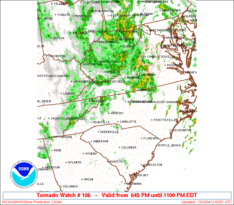
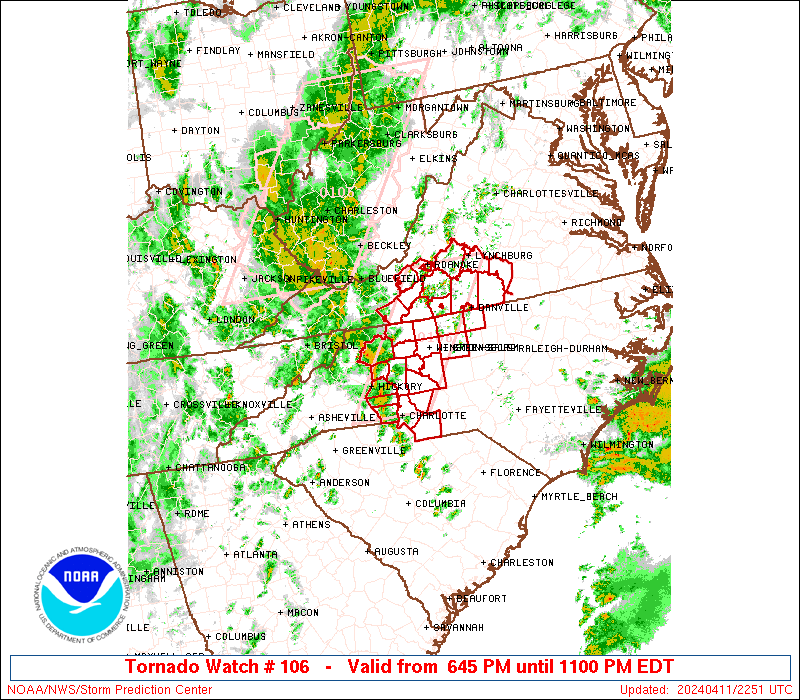
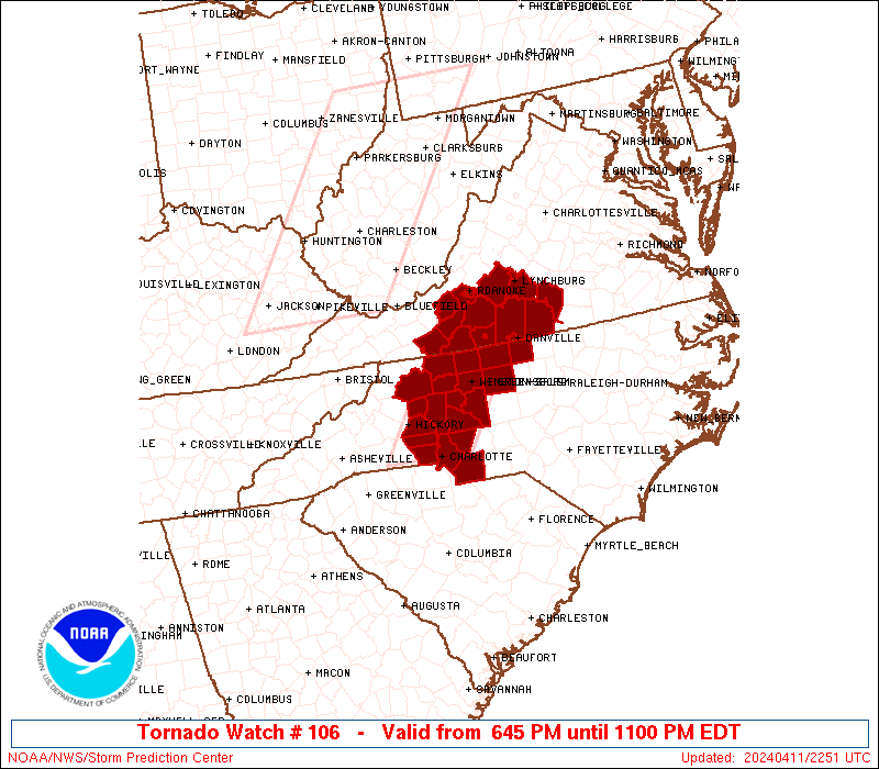
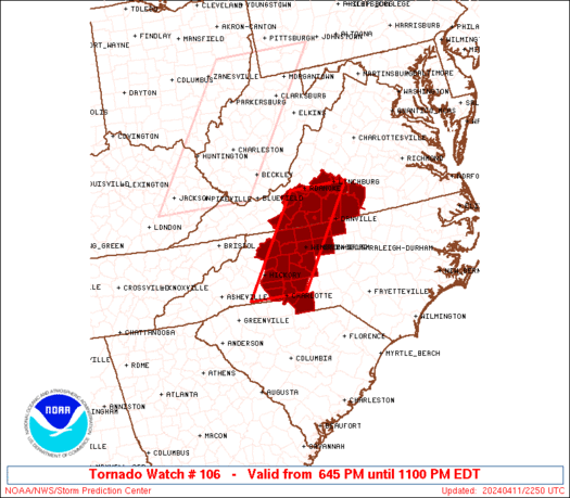
Tornado Watch Number 106
NWS Storm Prediction Center Norman OK
645 PM EDT Thu Apr 11 2024
The NWS Storm Prediction Center has issued a
* Tornado Watch for portions of
Western North Carolina
South central Virginia
* Effective this Thursday evening from 645 PM until 1100 PM EDT.
* Primary threats include...
A couple tornadoes possible
Scattered damaging wind gusts to 65 mph possible
SUMMARY...Scattered storm clusters and isolated supercells will be
possible this evening from western North Carolina into southern
Virginia, with the potential for a couple of tornadoes and damaging
gusts up to 65 mph.
The tornado watch area is approximately along and 40 statute miles
east and west of a line from 20 miles east of Roanoke VA to 10 miles
west of Charlotte NC. For a complete depiction of the watch see the
associated watch outline update (WOUS64 KWNS WOU6).
PRECAUTIONARY/PREPAREDNESS ACTIONS...
REMEMBER...A Tornado Watch means conditions are favorable for
tornadoes and severe thunderstorms in and close to the watch
area. Persons in these areas should be on the lookout for
threatening weather conditions and listen for later statements
and possible warnings.
&&
OTHER WATCH INFORMATION...CONTINUE...WW 105...
AVIATION...Tornadoes and a few severe thunderstorms with hail
surface and aloft to 0.5 inches. Extreme turbulence and surface wind
gusts to 55 knots. A few cumulonimbi with maximum tops to 450. Mean
storm motion vector 22035.
...Thompson

   SEL6

   URGENT - IMMEDIATE BROADCAST REQUESTED
   Tornado Watch Number 106
   NWS Storm Prediction Center Norman OK
   645 PM EDT Thu Apr 11 2024

   The NWS Storm Prediction Center has issued a

   * Tornado Watch for portions of
     Western North Carolina
     South central Virginia

   * Effective this Thursday evening from 645 PM until 1100 PM EDT.

   * Primary threats include...
     A couple tornadoes possible
     Scattered damaging wind gusts to 65 mph possible

   SUMMARY...Scattered storm clusters and isolated supercells will be
   possible this evening from western North Carolina into southern
   Virginia, with the potential for a couple of tornadoes and damaging
   gusts up to 65 mph.

   The tornado watch area is approximately along and 40 statute miles
   east and west of a line from 20 miles east of Roanoke VA to 10 miles
   west of Charlotte NC. For a complete depiction of the watch see the
   associated watch outline update (WOUS64 KWNS WOU6).

   PRECAUTIONARY/PREPAREDNESS ACTIONS...

   REMEMBER...A Tornado Watch means conditions are favorable for
   tornadoes and severe thunderstorms in and close to the watch
   area. Persons in these areas should be on the lookout for
   threatening weather conditions and listen for later statements
   and possible warnings.

   &&

   OTHER WATCH INFORMATION...CONTINUE...WW 105...

   AVIATION...Tornadoes and a few severe thunderstorms with hail
   surface and aloft to 0.5 inches. Extreme turbulence and surface wind
   gusts to 55 knots. A few cumulonimbi with maximum tops to 450. Mean
   storm motion vector 22035.

   ...Thompson
 Note:
The Aviation Watch (SAW) product is an approximation to the watch area.
The actual watch is depicted by the shaded areas.
Note:
The Aviation Watch (SAW) product is an approximation to the watch area.
The actual watch is depicted by the shaded areas.
   SAW6
   WW 106 TORNADO NC VA 112245Z - 120300Z
   AXIS..40 STATUTE MILES EAST AND WEST OF LINE..
   20E ROA/ROANOKE VA/ - 10W CLT/CHARLOTTE NC/
   ..AVIATION COORDS.. 35NM E/W /19WNW LYH - 10W CLT/
   HAIL SURFACE AND ALOFT..0.5 INCH. WIND GUSTS..55 KNOTS.
   MAX TOPS TO 450. MEAN STORM MOTION VECTOR 22035.

   LAT...LON 37327889 35228042 35228183 37328033

   THIS IS AN APPROXIMATION TO THE WATCH AREA.  FOR A
   COMPLETE DEPICTION OF THE WATCH SEE WOUS64 KWNS
   FOR WOU6.
Watch 106 Status Report Messages:
STATUS REPORT #4 ON WW 106
VALID 120250Z - 120300Z
SEVERE WEATHER THREAT CONTINUES RIGHT OF A LINE FROM 35 E DAN TO
15 ENE DAN TO 25 SSW SHD.
WW 106 WILL BE ALLOWED TO EXPIRE AT 120300Z.
..LYONS..04/12/24
ATTN...WFO...GSP...RNK...RAH...
&&
STATUS REPORT FOR WT 106
SEVERE WEATHER THREAT CONTINUES FOR THE FOLLOWING AREAS
VAC011-029-037-083-120300-
VA
. VIRGINIA COUNTIES INCLUDED ARE
APPOMATTOX BUCKINGHAM CHARLOTTE
HALIFAX
$$
THE WATCH STATUS MESSAGE IS FOR GUIDANCE PURPOSES ONLY. PLEASE
REFER TO WATCH COUNTY NOTIFICATION STATEMENTS FOR OFFICIAL
INFORMATION ON COUNTIES...INDEPENDENT CITIES AND MARINE ZONES
CLEARED FROM SEVERE THUNDERSTORM AND TORNADO WATCHES.
$$
STATUS REPORT #3 ON WW 106
VALID 120155Z - 120240Z
SEVERE WEATHER THREAT CONTINUES RIGHT OF A LINE FROM 25 SSW SOP
TO 20 SE GSO TO 20 WNW DAN TO 25 SW LYH TO 15 NE ROA.
..LYONS..04/12/24
ATTN...WFO...GSP...RNK...RAH...
&&
STATUS REPORT FOR WT 106
SEVERE WEATHER THREAT CONTINUES FOR THE FOLLOWING AREAS
NCC001-033-037-105-125-135-145-120240-
NC
. NORTH CAROLINA COUNTIES INCLUDED ARE
ALAMANCE CASWELL CHATHAM
LEE MOORE ORANGE
PERSON
$$
VAC011-019-029-031-037-083-143-590-680-120240-
VA
. VIRGINIA COUNTIES INCLUDED ARE
APPOMATTOX BEDFORD BUCKINGHAM
CAMPBELL CHARLOTTE HALIFAX
PITTSYLVANIA
VIRGINIA INDEPENDENT CITIES INCLUDED ARE
DANVILLE LYNCHBURG
$$
THE WATCH STATUS MESSAGE IS FOR GUIDANCE PURPOSES ONLY. PLEASE
REFER TO WATCH COUNTY NOTIFICATION STATEMENTS FOR OFFICIAL
INFORMATION ON COUNTIES...INDEPENDENT CITIES AND MARINE ZONES
CLEARED FROM SEVERE THUNDERSTORM AND TORNADO WATCHES.
$$
STATUS REPORT #2 ON WW 106
VALID 120055Z - 120140Z
SEVERE WEATHER THREAT CONTINUES RIGHT OF A LINE FROM 50 ESE CLT
TO 30 ENE CLT TO 30 NW GSO TO 15 NNW ROA.
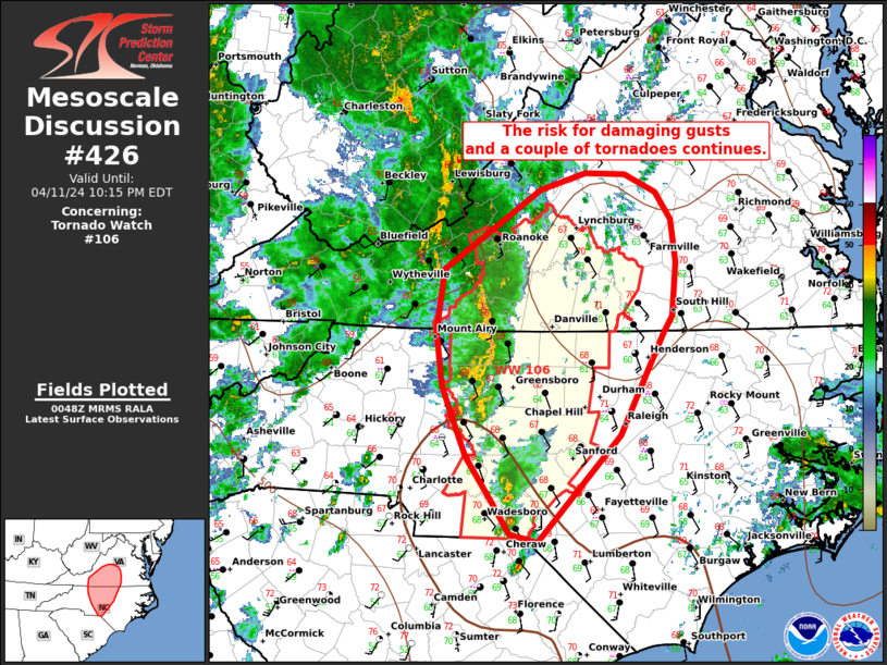
FOR ADDITIONAL INFORMATION SEE MESOSCALE DISCUSSION 426
..LYONS..04/12/24
ATTN...WFO...GSP...RNK...RAH...
&&
STATUS REPORT FOR WT 106
SEVERE WEATHER THREAT CONTINUES FOR THE FOLLOWING AREAS
NCC001-007-033-037-057-067-081-105-123-125-135-145-151-153-157-
167-169-120140-
NC
. NORTH CAROLINA COUNTIES INCLUDED ARE
ALAMANCE ANSON CASWELL
CHATHAM DAVIDSON FORSYTH
GUILFORD LEE MONTGOMERY
MOORE ORANGE PERSON
RANDOLPH RICHMOND ROCKINGHAM
STANLY STOKES
$$
VAC019-031-037-067-083-089-141-143-161-590-680-690-770-775-
120140-
VA
. VIRGINIA COUNTIES INCLUDED ARE
BEDFORD CAMPBELL CHARLOTTE
FRANKLIN HALIFAX HENRY
PATRICK PITTSYLVANIA ROANOKE
VIRGINIA INDEPENDENT CITIES INCLUDED ARE
DANVILLE LYNCHBURG MARTINSVILLE
ROANOKE SALEM
$$
THE WATCH STATUS MESSAGE IS FOR GUIDANCE PURPOSES ONLY. PLEASE
REFER TO WATCH COUNTY NOTIFICATION STATEMENTS FOR OFFICIAL
INFORMATION ON COUNTIES...INDEPENDENT CITIES AND MARINE ZONES
CLEARED FROM SEVERE THUNDERSTORM AND TORNADO WATCHES.
$$
STATUS REPORT #1 ON WW 106
VALID 112340Z - 120040Z
SEVERE WEATHER THREAT CONTINUES RIGHT OF A LINE FROM 15 W CLT TO
15 NE HKY TO 50 N HKY.
..LYONS..04/11/24
ATTN...WFO...GSP...RNK...RAH...
&&
STATUS REPORT FOR WT 106
SEVERE WEATHER THREAT CONTINUES FOR THE FOLLOWING AREAS
NCC003-025-033-035-057-059-067-071-081-097-109-119-157-159-169-
171-179-193-197-120040-
NC
. NORTH CAROLINA COUNTIES INCLUDED ARE
ALEXANDER CABARRUS CASWELL
CATAWBA DAVIDSON DAVIE
FORSYTH GASTON GUILFORD
IREDELL LINCOLN MECKLENBURG
ROCKINGHAM ROWAN STOKES
SURRY UNION WILKES
YADKIN
$$
VAC019-031-035-037-063-067-083-089-121-141-143-161-590-640-680-
690-750-770-775-120040-
VA
. VIRGINIA COUNTIES INCLUDED ARE
BEDFORD CAMPBELL CARROLL
CHARLOTTE FLOYD FRANKLIN
HALIFAX HENRY MONTGOMERY
PATRICK PITTSYLVANIA ROANOKE
VIRGINIA INDEPENDENT CITIES INCLUDED ARE
DANVILLE GALAX LYNCHBURG
MARTINSVILLE RADFORD ROANOKE
SALEM
$$
THE WATCH STATUS MESSAGE IS FOR GUIDANCE PURPOSES ONLY. PLEASE
REFER TO WATCH COUNTY NOTIFICATION STATEMENTS FOR OFFICIAL
INFORMATION ON COUNTIES...INDEPENDENT CITIES AND MARINE ZONES
CLEARED FROM SEVERE THUNDERSTORM AND TORNADO WATCHES.
$$
Note:
Click for Complete Product Text.
Tornadoes
Probability of 2 or more tornadoes
|
Mod (40%)
|
Probability of 1 or more strong (EF2-EF5) tornadoes
|
Low (20%)
|
Wind
Probability of 10 or more severe wind events
|
Mod (40%)
|
Probability of 1 or more wind events > 65 knots
|
Low (20%)
|
Hail
Probability of 10 or more severe hail events
|
Low (<5%)
|
Probability of 1 or more hailstones > 2 inches
|
Low (<5%)
|
Combined Severe Hail/Wind
Probability of 6 or more combined severe hail/wind events
|
Mod (50%)
|
For each watch, probabilities for particular events inside the watch
(listed above in each table) are determined by the issuing forecaster.
The "Low" category contains probability values ranging from less than 2%
to 20% (EF2-EF5 tornadoes), less than 5% to 20% (all other probabilities),
"Moderate" from 30% to 60%, and "High" from 70% to greater than 95%.
High values are bolded and lighter in color to provide awareness of
an increased threat for a particular event.


 @NWSSPC