Note:
The expiration time in the watch graphic is amended if the watch is
replaced, cancelled or extended.
Note:
Note:
The expiration time in the watch graphic is amended if the watch is
replaced, cancelled or extended.
Note: Click for
Watch Status Reports.
SEL2
URGENT - IMMEDIATE BROADCAST REQUESTED
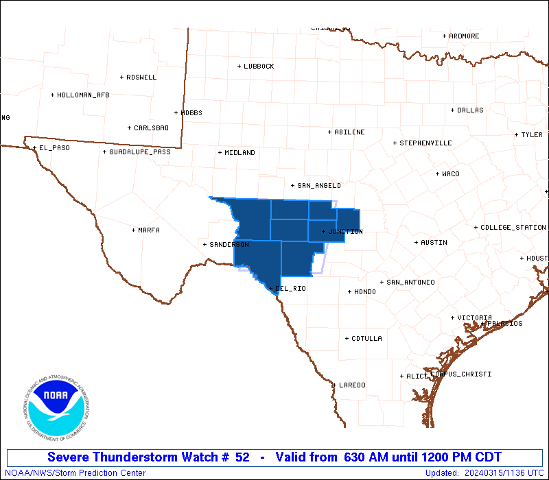
Severe Thunderstorm Watch Number 52
NWS Storm Prediction Center Norman OK
630 AM CDT Fri Mar 15 2024
The NWS Storm Prediction Center has issued a
* Severe Thunderstorm Watch for portions of
The Edwards Plateau of Texas
* Effective this Friday morning from 630 AM until NOON CDT.
* Primary threats include...
Scattered large hail and isolated very large hail events to 2.5
inches in diameter possible
Isolated damaging wind gusts to 70 mph possible
A tornado or two possible
SUMMARY...Supercells may persist for a few hours this morning near a
slow-moving cold front. Very large hail up to 2.5 inches in
diameter will be the main threat, though isolated damaging gusts of
60-70 mph and an isolated tornado may also occur.
The severe thunderstorm watch area is approximately along and 55
statute miles east and west of a line from 55 miles northwest of
Junction TX to 80 miles southwest of Junction TX. For a complete
depiction of the watch see the associated watch outline update
(WOUS64 KWNS WOU2).
PRECAUTIONARY/PREPAREDNESS ACTIONS...
REMEMBER...A Severe Thunderstorm Watch means conditions are
favorable for severe thunderstorms in and close to the watch area.
Persons in these areas should be on the lookout for threatening
weather conditions and listen for later statements and possible
warnings. Severe thunderstorms can and occasionally do produce
tornadoes.
&&
OTHER WATCH INFORMATION...CONTINUE...WW 51...
AVIATION...A few severe thunderstorms with hail surface and aloft to
2.5 inches. Extreme turbulence and surface wind gusts to 60 knots. A
few cumulonimbi with maximum tops to 550. Mean storm motion vector
27015.
...Thompson

   SEL2

   URGENT - IMMEDIATE BROADCAST REQUESTED
   Severe Thunderstorm Watch Number 52
   NWS Storm Prediction Center Norman OK
   630 AM CDT Fri Mar 15 2024

   The NWS Storm Prediction Center has issued a

   * Severe Thunderstorm Watch for portions of
     The Edwards Plateau of Texas

   * Effective this Friday morning from 630 AM until NOON CDT.

   * Primary threats include...
     Scattered large hail and isolated very large hail events to 2.5
       inches in diameter possible
     Isolated damaging wind gusts to 70 mph possible
     A tornado or two possible

   SUMMARY...Supercells may persist for a few hours this morning near a
   slow-moving cold front.  Very large hail up to 2.5 inches in
   diameter will be the main threat, though isolated damaging gusts of
   60-70 mph and an isolated tornado may also occur.

   The severe thunderstorm watch area is approximately along and 55
   statute miles east and west of a line from 55 miles northwest of
   Junction TX to 80 miles southwest of Junction TX. For a complete
   depiction of the watch see the associated watch outline update
   (WOUS64 KWNS WOU2).

   PRECAUTIONARY/PREPAREDNESS ACTIONS...

   REMEMBER...A Severe Thunderstorm Watch means conditions are
   favorable for severe thunderstorms in and close to the watch area.
   Persons in these areas should be on the lookout for threatening
   weather conditions and listen for later statements and possible
   warnings. Severe thunderstorms can and occasionally do produce
   tornadoes.

   &&

   OTHER WATCH INFORMATION...CONTINUE...WW 51...

   AVIATION...A few severe thunderstorms with hail surface and aloft to
   2.5 inches. Extreme turbulence and surface wind gusts to 60 knots. A
   few cumulonimbi with maximum tops to 550. Mean storm motion vector
   27015.

   ...Thompson
 Note:
The Aviation Watch (SAW) product is an approximation to the watch area.
The actual watch is depicted by the shaded areas.
Note:
The Aviation Watch (SAW) product is an approximation to the watch area.
The actual watch is depicted by the shaded areas.
   SAW2
   WW 52 SEVERE TSTM TX 151130Z - 151700Z
   AXIS..55 STATUTE MILES EAST AND WEST OF LINE..
   55NW JCT/JUNCTION TX/ - 80SW JCT/JUNCTION TX/
   ..AVIATION COORDS.. 50NM E/W /18S SJT - 21N DLF/
   HAIL SURFACE AND ALOFT..2.5 INCHES. WIND GUSTS..60 KNOTS.
   MAX TOPS TO 550. MEAN STORM MOTION VECTOR 27015.

   LAT...LON 31089950 29699980 29690163 31080136

   THIS IS AN APPROXIMATION TO THE WATCH AREA.  FOR A
   COMPLETE DEPICTION OF THE WATCH SEE WOUS64 KWNS
   FOR WOU2.
Watch 52 Status Report Messages:
STATUS REPORT #2 ON WW 52

VALID 151530Z - 151640Z

SEVERE WEATHER THREAT CONTINUES RIGHT OF A LINE FROM 25 SSE JCT
TO 40 SW BWD.

..LEITMAN..03/15/24

ATTN...WFO...SJT...EWX...

&&

STATUS REPORT FOR WS 52

SEVERE WEATHER THREAT CONTINUES FOR THE FOLLOWING AREAS

TXC307-319-411-151640-

TX
.    TEXAS COUNTIES INCLUDED ARE

MCCULLOCH	     MASON		 SAN SABA
$$


THE WATCH STATUS MESSAGE IS FOR GUIDANCE PURPOSES ONLY.  PLEASE
REFER TO WATCH COUNTY NOTIFICATION STATEMENTS FOR OFFICIAL
INFORMATION ON COUNTIES...INDEPENDENT CITIES AND MARINE ZONES
CLEARED FROM SEVERE THUNDERSTORM AND TORNADO WATCHES.
$$

STATUS REPORT #1 ON WW 52

VALID 151220Z - 151340Z

THE SEVERE WEATHER THREAT CONTINUES ACROSS THE ENTIRE WATCH AREA.

..DEAN..03/15/24

ATTN...WFO...SJT...EWX...

&&

STATUS REPORT FOR WS 52

SEVERE WEATHER THREAT CONTINUES FOR THE FOLLOWING AREAS

TXC105-137-267-319-327-413-435-465-151340-

TX
.    TEXAS COUNTIES INCLUDED ARE

CROCKETT	     EDWARDS		 KIMBLE
MASON		     MENARD		 SCHLEICHER
SUTTON		     VAL VERDE
$$


THE WATCH STATUS MESSAGE IS FOR GUIDANCE PURPOSES ONLY.  PLEASE
REFER TO WATCH COUNTY NOTIFICATION STATEMENTS FOR OFFICIAL
INFORMATION ON COUNTIES...INDEPENDENT CITIES AND MARINE ZONES
CLEARED FROM SEVERE THUNDERSTORM AND TORNADO WATCHES.
$$
Note:
Click for Complete Product Text.
Tornadoes
Probability of 2 or more tornadoes
|
Low (20%)
|
Probability of 1 or more strong (EF2-EF5) tornadoes
|
Low (<2%)
|
Wind
Probability of 10 or more severe wind events
|
Low (20%)
|
Probability of 1 or more wind events > 65 knots
|
Low (20%)
|
Hail
Probability of 10 or more severe hail events
|
Mod (40%)
|
Probability of 1 or more hailstones > 2 inches
|
Mod (40%)
|
Combined Severe Hail/Wind
Probability of 6 or more combined severe hail/wind events
|
Mod (60%)
|
For each watch, probabilities for particular events inside the watch
(listed above in each table) are determined by the issuing forecaster.
The "Low" category contains probability values ranging from less than 2%
to 20% (EF2-EF5 tornadoes), less than 5% to 20% (all other probabilities),
"Moderate" from 30% to 60%, and "High" from 70% to greater than 95%.
High values are bolded and lighter in color to provide awareness of
an increased threat for a particular event.


 @NWSSPC