 Note:
The expiration time in the watch graphic is amended if the watch is
replaced, cancelled or extended.
Note:
Note:
The expiration time in the watch graphic is amended if the watch is
replaced, cancelled or extended.
Note: Click for
Watch Status Reports.
SEL9
URGENT - IMMEDIATE BROADCAST REQUESTED
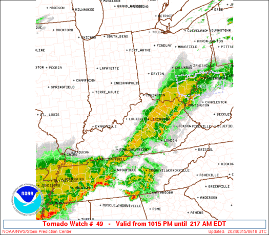
Tornado Watch Number 49
NWS Storm Prediction Center Norman OK
1015 PM EDT Thu Mar 14 2024
The NWS Storm Prediction Center has issued a
* Tornado Watch for portions of
Southern Indiana
Central and Northern Kentucky
Southern Ohio
* Effective this Thursday night and Friday morning from 1015 PM
until 400 AM EDT.
* Primary threats include...
A couple tornadoes possible
Scattered damaging winds likely with isolated significant gusts
to 75 mph possible
Scattered large hail events to 1.5 inches in diameter possible
SUMMARY...A fast-moving line of storms over southern Indiana will
track eastward across the watch area tonight, with isolated severe
cells ahead of the line. Damaging winds, hail, and a few tornadoes
are all possible through the evening and early morning.
The tornado watch area is approximately along and 40 statute miles
north and south of a line from 85 miles southwest of Louisville KY
to 120 miles northeast of Lexington KY. For a complete depiction of
the watch see the associated watch outline update (WOUS64 KWNS
WOU9).
PRECAUTIONARY/PREPAREDNESS ACTIONS...
REMEMBER...A Tornado Watch means conditions are favorable for
tornadoes and severe thunderstorms in and close to the watch
area. Persons in these areas should be on the lookout for
threatening weather conditions and listen for later statements
and possible warnings.
&&
OTHER WATCH INFORMATION...CONTINUE...WW 44...WW 45...WW 46...WW
47...WW 48...
AVIATION...Tornadoes and a few severe thunderstorms with hail
surface and aloft to 1.5 inches. Extreme turbulence and surface wind
gusts to 65 knots. A few cumulonimbi with maximum tops to 500. Mean
storm motion vector 27035.
...Hart

   SEL9

   URGENT - IMMEDIATE BROADCAST REQUESTED
   Tornado Watch Number 49
   NWS Storm Prediction Center Norman OK
   1015 PM EDT Thu Mar 14 2024

   The NWS Storm Prediction Center has issued a

   * Tornado Watch for portions of
     Southern Indiana
     Central and Northern Kentucky
     Southern Ohio

   * Effective this Thursday night and Friday morning from 1015 PM
     until 400 AM EDT.

   * Primary threats include...
     A couple tornadoes possible
     Scattered damaging winds likely with isolated significant gusts
       to 75 mph possible
     Scattered large hail events to 1.5 inches in diameter possible

   SUMMARY...A fast-moving line of storms over southern Indiana will
   track eastward across the watch area tonight, with isolated severe
   cells ahead of the line.  Damaging winds, hail, and a few tornadoes
   are all possible through the evening and early morning.

   The tornado watch area is approximately along and 40 statute miles
   north and south of a line from 85 miles southwest of Louisville KY
   to 120 miles northeast of Lexington KY. For a complete depiction of
   the watch see the associated watch outline update (WOUS64 KWNS
   WOU9).

   PRECAUTIONARY/PREPAREDNESS ACTIONS...

   REMEMBER...A Tornado Watch means conditions are favorable for
   tornadoes and severe thunderstorms in and close to the watch
   area. Persons in these areas should be on the lookout for
   threatening weather conditions and listen for later statements
   and possible warnings.

   &&

   OTHER WATCH INFORMATION...CONTINUE...WW 44...WW 45...WW 46...WW
   47...WW 48...

   AVIATION...Tornadoes and a few severe thunderstorms with hail
   surface and aloft to 1.5 inches. Extreme turbulence and surface wind
   gusts to 65 knots. A few cumulonimbi with maximum tops to 500. Mean
   storm motion vector 27035.

   ...Hart
 Note:
The Aviation Watch (SAW) product is an approximation to the watch area.
The actual watch is depicted by the shaded areas.
Note:
The Aviation Watch (SAW) product is an approximation to the watch area.
The actual watch is depicted by the shaded areas.
   SAW9
   WW 49 TORNADO IN KY OH 150215Z - 150800Z
   AXIS..40 STATUTE MILES NORTH AND SOUTH OF LINE..
   85SW SDF/LOUISVILLE KY/ - 120NE LEX/LEXINGTON KY/
   ..AVIATION COORDS.. 35NM N/S /29NW BWG - 55WNW HNN/
   HAIL SURFACE AND ALOFT..1.5 INCHES. WIND GUSTS..65 KNOTS.
   MAX TOPS TO 500. MEAN STORM MOTION VECTOR 27035.

   LAT...LON 37888682 39838301 38668301 36738682

   THIS IS AN APPROXIMATION TO THE WATCH AREA.  FOR A
   COMPLETE DEPICTION OF THE WATCH SEE WOUS64 KWNS
   FOR WOU9.
Watch 49 Status Report Messages:
STATUS REPORT #2 ON WW 49

VALID 150540Z - 150640Z

SEVERE WEATHER THREAT CONTINUES RIGHT OF A LINE FROM 60 W LOZ TO
10 S LEX TO 10 S UNI.

FOR ADDITIONAL INFORMATION SEE MESOSCALE DISCUSSION 251

..DEAN..03/15/24

ATTN...WFO...LMK...ILN...JKL...

&&

STATUS REPORT FOR WT 49

SEVERE WEATHER THREAT CONTINUES FOR THE FOLLOWING AREAS

KYC011-049-173-205-150640-

KY
.    KENTUCKY COUNTIES INCLUDED ARE

BATH		     CLARK		 MONTGOMERY
ROWAN
$$


THE WATCH STATUS MESSAGE IS FOR GUIDANCE PURPOSES ONLY.  PLEASE
REFER TO WATCH COUNTY NOTIFICATION STATEMENTS FOR OFFICIAL
INFORMATION ON COUNTIES...INDEPENDENT CITIES AND MARINE ZONES
CLEARED FROM SEVERE THUNDERSTORM AND TORNADO WATCHES.
$$

STATUS REPORT #1 ON WW 49

VALID 150425Z - 150540Z

SEVERE WEATHER THREAT CONTINUES RIGHT OF A LINE FROM 30 E CKV TO
15 SSW SDF TO 40 WNW UNI.

FOR ADDITIONAL INFORMATION SEE MESOSCALE DISCUSSION 251

..HART..03/15/24

ATTN...WFO...LMK...ILN...JKL...

&&

STATUS REPORT FOR WT 49

SEVERE WEATHER THREAT CONTINUES FOR THE FOLLOWING AREAS

KYC005-011-017-023-029-049-061-067-069-073-085-087-093-097-099-
103-113-123-135-141-155-161-167-173-179-181-187-191-201-205-209-
211-213-215-217-227-229-239-150540-

KY
.    KENTUCKY COUNTIES INCLUDED ARE

ANDERSON	     BATH		 BOURBON
BRACKEN 	     BULLITT		 CLARK
EDMONSON	     FAYETTE		 FLEMING
FRANKLIN	     GRAYSON		 GREEN
HARDIN		     HARRISON		 HART
HENRY		     JESSAMINE		 LARUE
LEWIS		     LOGAN		 MARION
MASON		     MERCER		 MONTGOMERY
NELSON		     NICHOLAS		 OWEN
PENDLETON	     ROBERTSON		 ROWAN
SCOTT		     SHELBY		 SIMPSON
SPENCER 	     TAYLOR		 WARREN
WASHINGTON	     WOODFORD
$$


OHC001-015-131-145-150540-

OH
.    OHIO COUNTIES INCLUDED ARE

ADAMS		     BROWN		 PIKE
SCIOTO
$$


THE WATCH STATUS MESSAGE IS FOR GUIDANCE PURPOSES ONLY.  PLEASE
REFER TO WATCH COUNTY NOTIFICATION STATEMENTS FOR OFFICIAL
INFORMATION ON COUNTIES...INDEPENDENT CITIES AND MARINE ZONES
CLEARED FROM SEVERE THUNDERSTORM AND TORNADO WATCHES.
$$
Note:
Click for Complete Product Text.
Tornadoes
Probability of 2 or more tornadoes
|
Mod (40%)
|
Probability of 1 or more strong (EF2-EF5) tornadoes
|
Low (10%)
|
Wind
Probability of 10 or more severe wind events
|
Mod (60%)
|
Probability of 1 or more wind events > 65 knots
|
Mod (30%)
|
Hail
Probability of 10 or more severe hail events
|
Mod (40%)
|
Probability of 1 or more hailstones > 2 inches
|
Low (20%)
|
Combined Severe Hail/Wind
Probability of 6 or more combined severe hail/wind events
|
High (90%)
|
For each watch, probabilities for particular events inside the watch
(listed above in each table) are determined by the issuing forecaster.
The "Low" category contains probability values ranging from less than 2%
to 20% (EF2-EF5 tornadoes), less than 5% to 20% (all other probabilities),
"Moderate" from 30% to 60%, and "High" from 70% to greater than 95%.
High values are bolded and lighter in color to provide awareness of
an increased threat for a particular event.


 @NWSSPC


