|
Initial List of Counties in SPC Severe Thunderstorm Watch 411 (WOU)
|
Back to Watch 411
|
 |
WOUS64 KWNS 132241
WOU1
BULLETIN - IMMEDIATE BROADCAST REQUESTED
SEVERE THUNDERSTORM WATCH OUTLINE UPDATE FOR WS 411
NWS STORM PREDICTION CENTER NORMAN OK
540 PM CDT THU JUN 13 2024
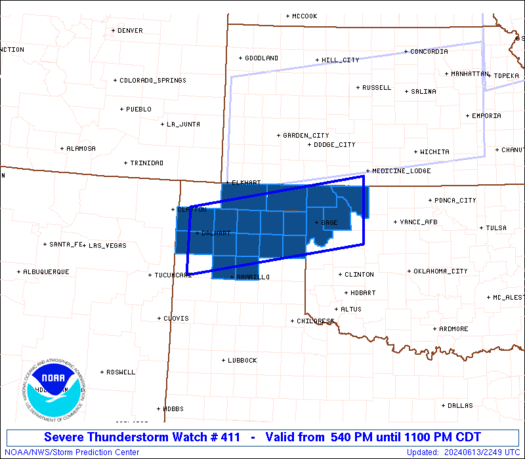
SEVERE THUNDERSTORM WATCH 411 IS IN EFFECT UNTIL 1100 PM CDT
FOR THE FOLLOWING LOCATIONS
OKC007-045-059-139-151-153-140400-
/O.NEW.KWNS.SV.A.0411.240613T2240Z-240614T0400Z/
OK
. OKLAHOMA COUNTIES INCLUDED ARE
BEAVER ELLIS HARPER
TEXAS WOODS WOODWARD
TXC065-111-195-205-211-233-295-341-357-375-393-421-140400-
/O.NEW.KWNS.SV.A.0411.240613T2240Z-240614T0400Z/
TX
. TEXAS COUNTIES INCLUDED ARE
CARSON DALLAM HANSFORD
HARTLEY HEMPHILL HUTCHINSON
LIPSCOMB MOORE OCHILTREE
POTTER ROBERTS SHERMAN
ATTN...WFO...AMA...OUN...
|
| Aviation Watch (SAW) for WW411 |
|---|
 |
| Note:
The Aviation Watch (SAW) product is an approximation to the watch area.
The actual watch is depicted by the shaded areas. |
   SAW1
   WW 411 SEVERE TSTM OK TX 132240Z - 140400Z
   AXIS..45 STATUTE MILES NORTH AND SOUTH OF LINE..
   15SW DHT/DALHART TX/ - 15S AVK/ALVA OK/
   ..AVIATION COORDS.. 40NM N/S /59NE TCC - 38WNW END/
   HAIL SURFACE AND ALOFT..1 INCH. WIND GUSTS..65 KNOTS.
   MAX TOPS TO 500. MEAN STORM MOTION VECTOR 32020.

   LAT...LON 36520274 37209867 35909867 35220274

   THIS IS AN APPROXIMATION TO THE WATCH AREA.  FOR A
   COMPLETE DEPICTION OF THE WATCH SEE WOUS64 KWNS
   FOR WOU1.
|
|


 @NWSSPC
