Note:
The expiration time in the watch graphic is amended if the watch is
replaced, cancelled or extended.
Note:
Note:
The expiration time in the watch graphic is amended if the watch is
replaced, cancelled or extended.
Note: Click for
Watch Status Reports.
SEL2
URGENT - IMMEDIATE BROADCAST REQUESTED
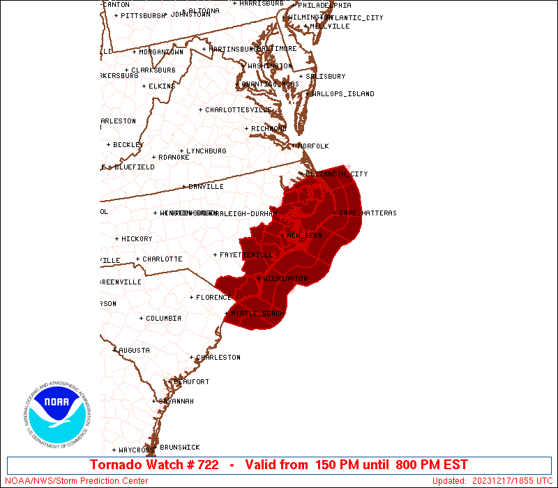
Tornado Watch Number 722
NWS Storm Prediction Center Norman OK
150 PM EST Sun Dec 17 2023
The NWS Storm Prediction Center has issued a
* Tornado Watch for portions of
eastern North Carolina
Coastal Waters
* Effective this Sunday afternoon and evening from 150 PM until
800 PM EST.
* Primary threats include...
A few tornadoes and a couple intense tornadoes possible
Scattered damaging wind gusts to 65 mph possible
SUMMARY...Potential for locally damaging winds and a couple of
tornadoes will gradually increase this afternoon and into this
evening, as locally intense thunderstorms shift north-northeastward
across the North Carolina Coastal Plain and Outer Banks area.
The tornado watch area is approximately along and 45 statute miles
east and west of a line from 110 miles northeast of New Bern NC to
30 miles south of Wilmington NC. For a complete depiction of the
watch see the associated watch outline update (WOUS64 KWNS WOU2).
PRECAUTIONARY/PREPAREDNESS ACTIONS...
REMEMBER...A Tornado Watch means conditions are favorable for
tornadoes and severe thunderstorms in and close to the watch
area. Persons in these areas should be on the lookout for
threatening weather conditions and listen for later statements
and possible warnings.
&&
AVIATION...Tornadoes and a few severe thunderstorms with hail
surface and aloft to 0.5 inches. Extreme turbulence and surface wind
gusts to 55 knots. A few cumulonimbi with maximum tops to 400. Mean
storm motion vector 18040.
...Goss

   SEL2

   URGENT - IMMEDIATE BROADCAST REQUESTED
   Tornado Watch Number 722
   NWS Storm Prediction Center Norman OK
   150 PM EST Sun Dec 17 2023

   The NWS Storm Prediction Center has issued a

   * Tornado Watch for portions of
     eastern North Carolina
     Coastal Waters

   * Effective this Sunday afternoon and evening from 150 PM until
     800 PM EST.

   * Primary threats include...
     A few tornadoes and a couple intense tornadoes possible
     Scattered damaging wind gusts to 65 mph possible

   SUMMARY...Potential for locally damaging winds and a couple of
   tornadoes will gradually increase this afternoon and into this
   evening, as locally intense thunderstorms shift north-northeastward
   across the North Carolina Coastal Plain and Outer Banks area.

   The tornado watch area is approximately along and 45 statute miles
   east and west of a line from 110 miles northeast of New Bern NC to
   30 miles south of Wilmington NC. For a complete depiction of the
   watch see the associated watch outline update (WOUS64 KWNS WOU2).

   PRECAUTIONARY/PREPAREDNESS ACTIONS...

   REMEMBER...A Tornado Watch means conditions are favorable for
   tornadoes and severe thunderstorms in and close to the watch
   area. Persons in these areas should be on the lookout for
   threatening weather conditions and listen for later statements
   and possible warnings.

   &&

   AVIATION...Tornadoes and a few severe thunderstorms with hail
   surface and aloft to 0.5 inches. Extreme turbulence and surface wind
   gusts to 55 knots. A few cumulonimbi with maximum tops to 400. Mean
   storm motion vector 18040.

   ...Goss
 Note:
The Aviation Watch (SAW) product is an approximation to the watch area.
The actual watch is depicted by the shaded areas.
Note:
The Aviation Watch (SAW) product is an approximation to the watch area.
The actual watch is depicted by the shaded areas.
   SAW2
   WW 722 TORNADO NC CW 171850Z - 180100Z
   AXIS..45 STATUTE MILES EAST AND WEST OF LINE..
   110NE EWN/NEW BERN NC/ - 30S ILM/WILMINGTON NC/
   ..AVIATION COORDS.. 40NM E/W /26E ECG - 31S ILM/
   HAIL SURFACE AND ALOFT..0.5 INCH. WIND GUSTS..55 KNOTS.
   MAX TOPS TO 400. MEAN STORM MOTION VECTOR 18040.

   LAT...LON 36187485 33837712 33837868 36187646

   THIS IS AN APPROXIMATION TO THE WATCH AREA.  FOR A
   COMPLETE DEPICTION OF THE WATCH SEE WOUS64 KWNS
   FOR WOU2.
Watch 722 Status Report Messages:
STATUS REPORT #3 ON WW 722

VALID 180040Z - 180140Z

THE SEVERE WEATHER THREAT CONTINUES ACROSS THE ENTIRE WATCH AREA.

..SPC..12/18/23

ATTN...WFO...MHX...ILM...

&&

STATUS REPORT FOR WT 722

SEVERE WEATHER THREAT CONTINUES FOR THE FOLLOWING AREAS

NCC013-019-031-047-049-055-061-095-103-107-129-133-137-141-177-
187-180140-

NC
.    NORTH CAROLINA COUNTIES INCLUDED ARE

BEAUFORT	     BRUNSWICK		 CARTERET
COLUMBUS	     CRAVEN		 DARE
DUPLIN		     HYDE		 JONES
LENOIR		     NEW HANOVER	 ONSLOW
PAMLICO 	     PENDER		 TYRRELL
WASHINGTON
$$


AMZ131-135-136-137-150-152-154-156-158-170-172-174-176-178-230-
231-250-252-254-270-272-274-180140-

CW

.    ADJACENT COASTAL WATERS INCLUDED ARE

ALLIGATOR RIVER

PAMLICO SOUND

PAMLICO AND PUNGO RIVERS

NEUSE AND BAY RIVERS

S OF CURRITUCK BEACH LIGHT NC TO OREGON INLET NC OUT TO 20 NM

S OF OREGON INLET NC TO CAPE HATTERAS NC OUT TO 20 NM

S OF CAPE HATTERAS NC TO OCRACOKE INLET NC OUT TO 20 NM

S OF OCRACOKE INLET NC TO CAPE LOOKOUT NC OUT TO 20 NM

S OF CAPE LOOKOUT NC TO SURF CITY NC OUT TO 20 NM

WATERS FROM CURRITUCK BEACH LIGHT TO OREGON INLET NC FROM 20 TO
40 NM

WATERS FROM OREGON INLET TO CAPE HATTERAS NC FROM 20 TO 40 NM

WATERS FROM CAPE HATTERAS TO OCRACOKE INLET NC FROM 20 TO 40 NM

WATERS FROMOCRACOKE INLET TO CAPE LOOKOUT NC FROM 20 TO 40 NM

WATERS FROM CAPE LOOKOUT  TO SURF CITY NC FROM 20 TO 40 NM

ALBEMARLE SOUND

CROATAN AND ROANOKE SOUNDS

COASTAL WATERS FROM SURF CITY TO CAPE FEAR NC OUT 20 NM

COASTAL WATERS FROM CAPE FEAR NC TO LITTLE RIVER INLET SC OUT 20
NM

COASTAL WATERS FROM LITTLE RIVER INLET TO MURRELLS INLET SC OUT
20 NM

WATERS FROM SURF CITY TO CAPE FEAR NC FROM 20 TO 40 NM

WATERS FROM CAPE FEAR NC TO LITTLE RIVER INLET SC FROM 20 TO 40
NM

WATERS FROM LITTLE RIVER INLET TO MURRELLS INLET SC FROM 20 TO 40
NM

$$
THE WATCH STATUS MESSAGE IS FOR GUIDANCE PURPOSES ONLY.  PLEASE
REFER TO WATCH COUNTY NOTIFICATION STATEMENTS FOR OFFICIAL
INFORMATION ON COUNTIES...INDEPENDENT CITIES AND MARINE ZONES
CLEARED FROM SEVERE THUNDERSTORM AND TORNADO WATCHES.
$$

STATUS REPORT #2 ON WW 722

VALID 172135Z - 172240Z

THE SEVERE WEATHER THREAT CONTINUES ACROSS THE ENTIRE WATCH AREA.

..THORNTON..12/17/23

ATTN...WFO...MHX...ILM...

&&

STATUS REPORT FOR WT 722

SEVERE WEATHER THREAT CONTINUES FOR THE FOLLOWING AREAS

NCC013-019-031-047-049-055-061-095-103-107-129-133-137-141-177-
187-172240-

NC
.    NORTH CAROLINA COUNTIES INCLUDED ARE

BEAUFORT	     BRUNSWICK		 CARTERET
COLUMBUS	     CRAVEN		 DARE
DUPLIN		     HYDE		 JONES
LENOIR		     NEW HANOVER	 ONSLOW
PAMLICO 	     PENDER		 TYRRELL
WASHINGTON
$$


AMZ131-135-136-137-150-152-154-156-158-170-172-174-176-178-230-
231-250-252-254-270-272-274-172240-

CW

.    ADJACENT COASTAL WATERS INCLUDED ARE

ALLIGATOR RIVER

PAMLICO SOUND

PAMLICO AND PUNGO RIVERS

NEUSE AND BAY RIVERS

S OF CURRITUCK BEACH LIGHT NC TO OREGON INLET NC OUT TO 20 NM

S OF OREGON INLET NC TO CAPE HATTERAS NC OUT TO 20 NM

S OF CAPE HATTERAS NC TO OCRACOKE INLET NC OUT TO 20 NM

S OF OCRACOKE INLET NC TO CAPE LOOKOUT NC OUT TO 20 NM

S OF CAPE LOOKOUT NC TO SURF CITY NC OUT TO 20 NM

WATERS FROM CURRITUCK BEACH LIGHT TO OREGON INLET NC FROM 20 TO
40 NM

WATERS FROM OREGON INLET TO CAPE HATTERAS NC FROM 20 TO 40 NM

WATERS FROM CAPE HATTERAS TO OCRACOKE INLET NC FROM 20 TO 40 NM

WATERS FROMOCRACOKE INLET TO CAPE LOOKOUT NC FROM 20 TO 40 NM

WATERS FROM CAPE LOOKOUT  TO SURF CITY NC FROM 20 TO 40 NM

ALBEMARLE SOUND

CROATAN AND ROANOKE SOUNDS

COASTAL WATERS FROM SURF CITY TO CAPE FEAR NC OUT 20 NM

COASTAL WATERS FROM CAPE FEAR NC TO LITTLE RIVER INLET SC OUT 20
NM

COASTAL WATERS FROM LITTLE RIVER INLET TO MURRELLS INLET SC OUT
20 NM

WATERS FROM SURF CITY TO CAPE FEAR NC FROM 20 TO 40 NM

WATERS FROM CAPE FEAR NC TO LITTLE RIVER INLET SC FROM 20 TO 40
NM

WATERS FROM LITTLE RIVER INLET TO MURRELLS INLET SC FROM 20 TO 40
NM

$$
THE WATCH STATUS MESSAGE IS FOR GUIDANCE PURPOSES ONLY.  PLEASE
REFER TO WATCH COUNTY NOTIFICATION STATEMENTS FOR OFFICIAL
INFORMATION ON COUNTIES...INDEPENDENT CITIES AND MARINE ZONES
CLEARED FROM SEVERE THUNDERSTORM AND TORNADO WATCHES.
$$

STATUS REPORT #1 ON WW 722

VALID 172025Z - 172140Z

THE SEVERE WEATHER THREAT CONTINUES ACROSS THE ENTIRE WATCH AREA.

..THORNTON..12/17/23

ATTN...WFO...MHX...ILM...

&&

STATUS REPORT FOR WT 722

SEVERE WEATHER THREAT CONTINUES FOR THE FOLLOWING AREAS

NCC013-019-031-047-049-055-061-095-103-107-129-133-137-141-177-
187-172140-

NC
.    NORTH CAROLINA COUNTIES INCLUDED ARE

BEAUFORT	     BRUNSWICK		 CARTERET
COLUMBUS	     CRAVEN		 DARE
DUPLIN		     HYDE		 JONES
LENOIR		     NEW HANOVER	 ONSLOW
PAMLICO 	     PENDER		 TYRRELL
WASHINGTON
$$


AMZ131-135-136-137-150-152-154-156-158-170-172-174-176-178-230-
231-250-252-254-270-272-274-172140-

CW

.    ADJACENT COASTAL WATERS INCLUDED ARE

ALLIGATOR RIVER

PAMLICO SOUND

PAMLICO AND PUNGO RIVERS

NEUSE AND BAY RIVERS

S OF CURRITUCK BEACH LIGHT NC TO OREGON INLET NC OUT TO 20 NM

S OF OREGON INLET NC TO CAPE HATTERAS NC OUT TO 20 NM

S OF CAPE HATTERAS NC TO OCRACOKE INLET NC OUT TO 20 NM

S OF OCRACOKE INLET NC TO CAPE LOOKOUT NC OUT TO 20 NM

S OF CAPE LOOKOUT NC TO SURF CITY NC OUT TO 20 NM

WATERS FROM CURRITUCK BEACH LIGHT TO OREGON INLET NC FROM 20 TO
40 NM

WATERS FROM OREGON INLET TO CAPE HATTERAS NC FROM 20 TO 40 NM

WATERS FROM CAPE HATTERAS TO OCRACOKE INLET NC FROM 20 TO 40 NM

WATERS FROMOCRACOKE INLET TO CAPE LOOKOUT NC FROM 20 TO 40 NM

WATERS FROM CAPE LOOKOUT  TO SURF CITY NC FROM 20 TO 40 NM

ALBEMARLE SOUND

CROATAN AND ROANOKE SOUNDS

COASTAL WATERS FROM SURF CITY TO CAPE FEAR NC OUT 20 NM

COASTAL WATERS FROM CAPE FEAR NC TO LITTLE RIVER INLET SC OUT 20
NM

COASTAL WATERS FROM LITTLE RIVER INLET TO MURRELLS INLET SC OUT
20 NM

WATERS FROM SURF CITY TO CAPE FEAR NC FROM 20 TO 40 NM

WATERS FROM CAPE FEAR NC TO LITTLE RIVER INLET SC FROM 20 TO 40
NM

WATERS FROM LITTLE RIVER INLET TO MURRELLS INLET SC FROM 20 TO 40
NM

$$
THE WATCH STATUS MESSAGE IS FOR GUIDANCE PURPOSES ONLY.  PLEASE
REFER TO WATCH COUNTY NOTIFICATION STATEMENTS FOR OFFICIAL
INFORMATION ON COUNTIES...INDEPENDENT CITIES AND MARINE ZONES
CLEARED FROM SEVERE THUNDERSTORM AND TORNADO WATCHES.
$$
Note:
Click for Complete Product Text.
Tornadoes
Probability of 2 or more tornadoes
|
Mod (50%)
|
Probability of 1 or more strong (EF2-EF5) tornadoes
|
Mod (30%)
|
Wind
Probability of 10 or more severe wind events
|
Mod (40%)
|
Probability of 1 or more wind events > 65 knots
|
Low (10%)
|
Hail
Probability of 10 or more severe hail events
|
Low (<5%)
|
Probability of 1 or more hailstones > 2 inches
|
Low (<5%)
|
Combined Severe Hail/Wind
Probability of 6 or more combined severe hail/wind events
|
Mod (60%)
|
For each watch, probabilities for particular events inside the watch
(listed above in each table) are determined by the issuing forecaster.
The "Low" category contains probability values ranging from less than 2%
to 20% (EF2-EF5 tornadoes), less than 5% to 20% (all other probabilities),
"Moderate" from 30% to 60%, and "High" from 70% to greater than 95%.
High values are bolded and lighter in color to provide awareness of
an increased threat for a particular event.


 @NWSSPC