Note:
The expiration time in the watch graphic is amended if the watch is
replaced, cancelled or extended.
Note:
Note:
The expiration time in the watch graphic is amended if the watch is
replaced, cancelled or extended.
Note: Click for
Watch Status Reports.
SEL2
URGENT - IMMEDIATE BROADCAST REQUESTED
Severe Thunderstorm Watch Number 252
NWS Storm Prediction Center Norman OK
155 PM EDT Fri May 20 2022
The NWS Storm Prediction Center has issued a
* Severe Thunderstorm Watch for portions of
Northern Lower Michigan
Lake Huron
Lake Michigan
Lake Superior
* Effective this Friday afternoon and evening from 155 PM until
700 PM EDT.
* Primary threats include...
Scattered large hail and isolated very large hail events to 2
inches in diameter possible
Scattered damaging wind gusts to 70 mph possible
A tornado or two possible
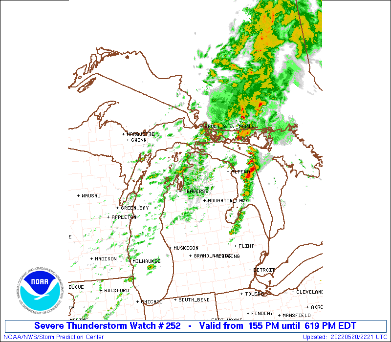
SUMMARY...A line of thunderstorms over Lake Michigan will track
quickly eastward this afternoon across northern Lower Michigan. The
stronger cells along the line will pose a risk of locally damaging
wind gusts and large hail. An isolated tornado or two is also
possible.
The severe thunderstorm watch area is approximately along and 70
statute miles east and west of a line from 35 miles southwest of
Houghton Lake MI to 35 miles east northeast of Sault Ste Marie MI.
For a complete depiction of the watch see the associated watch
outline update (WOUS64 KWNS WOU2).
PRECAUTIONARY/PREPAREDNESS ACTIONS...
REMEMBER...A Severe Thunderstorm Watch means conditions are
favorable for severe thunderstorms in and close to the watch area.
Persons in these areas should be on the lookout for threatening
weather conditions and listen for later statements and possible
warnings. Severe thunderstorms can and occasionally do produce
tornadoes.
&&
OTHER WATCH INFORMATION...CONTINUE...WW 251...
AVIATION...A few severe thunderstorms with hail surface and aloft to
2 inches. Extreme turbulence and surface wind gusts to 60 knots. A
few cumulonimbi with maximum tops to 500. Mean storm motion vector
24035.
...Hart
 Note:
The Aviation Watch (SAW) product is an approximation to the watch area.
The actual watch is depicted by the shaded areas.
Note:
The Aviation Watch (SAW) product is an approximation to the watch area.
The actual watch is depicted by the shaded areas.
   SAW2
   WW 252 SEVERE TSTM MI LH LM LS 201755Z - 202300Z
   AXIS..70 STATUTE MILES EAST AND WEST OF LINE..
   35SW HTL/HOUGHTON LAKE MI/ - 35ENE ANJ/SAULT STE MARIE MI/
   ..AVIATION COORDS.. 60NM E/W /44SSE TVC - 30ENE SSM/
   HAIL SURFACE AND ALOFT..2 INCHES. WIND GUSTS..60 KNOTS.
   MAX TOPS TO 500. MEAN STORM MOTION VECTOR 24035.

   LAT...LON 43988658 46658516 46658221 43988376

   THIS IS AN APPROXIMATION TO THE WATCH AREA.  FOR A
   COMPLETE DEPICTION OF THE WATCH SEE WOUS64 KWNS
   FOR WOU2.
Watch 252 Status Report Messages:
STATUS REPORT #1 ON WW 252

VALID 202000Z - 202140Z

THE SEVERE WEATHER THREAT CONTINUES ACROSS THE ENTIRE WATCH AREA.

FOR ADDITIONAL INFORMATION SEE MESOSCALE DISCUSSION 844

..JEWELL..05/20/22

ATTN...WFO...APX...

&&

STATUS REPORT FOR WS 252

SEVERE WEATHER THREAT CONTINUES FOR THE FOLLOWING AREAS

MIC001-007-009-019-029-031-033-039-047-055-079-089-097-101-113-
119-129-135-137-141-143-165-202140-

MI
.    MICHIGAN COUNTIES INCLUDED ARE

ALCONA		     ALPENA		 ANTRIM
BENZIE		     CHARLEVOIX 	 CHEBOYGAN
CHIPPEWA	     CRAWFORD		 EMMET
GRAND TRAVERSE	     KALKASKA		 LEELANAU
MACKINAC	     MANISTEE		 MISSAUKEE
MONTMORENCY	     OGEMAW		 OSCODA
OTSEGO		     PRESQUE ISLE	 ROSCOMMON
WEXFORD
$$


LHZ345-346-347-348-361-362-LMZ323-341-342-344-345-346-362-364-366-
LSZ321-322-202140-

CW

.    ADJACENT COASTAL WATERS INCLUDED ARE

GRAND TRAVERSE BAY SOUTH OF A LINE GRAND TRAVERSE LIGHT TO
NORWOOD MI

SEUL CHOIX POINT TO 5NM WEST OF MACKINAC BRIDGE

NORWOOD MI TO 5NM WEST OF MACKINAC BRIDGE INCLUDING LITTLE
TRAVERSE BAY

SLEEPING BEAR POINT TO GRAND TRAVERSE LIGHT MI

POINT BETSIE TO SLEEPING BEAR POINT MI

MANISTEE TO POINT BETSIE MI

LAKE MICHIGAN SOUTH OF A LINE FROM SEUL CHOIX POINT TO THE
MACKINAC BRIDGE AND NORTH OF A LINE FROM CHARLEVOIX MI TO SOUTH
FOX ISLAND 5NM OFFSHORE

LAKE MICHIGAN FROM CHARLEVOIX TO POINT BETSIE MI 5NM OFFSHORE TO
MID LAKE

LAKE MICHIGAN FROM POINT BETSIE TO MANISTEE MI 5NM OFFSHORE TO
MID LAKE

WHITEFISH BAY (U.S. PORTION)/WHITEFISH POINT TO POINT IROQUOIS MI

ST. MARYS RIVER POINT IROQUOIS TO E. POTAGANNISSING BAY

STRAITS OF MACKINAC WITHIN 5 NM OF MACKINAC BRIDGE INCLUDING
MACKINAC ISLAND

ST IGNACE TO FALSE DETOUR CHANNEL

5NM EAST OF MACKINAC BRIDGE TO PRESQUE ISLE LIGHT MI INCLUDING
BOIS BLANC ISLAND

PRESQUE ISLE LIGHT TO STURGEON PT MI INCLUDING THUNDER BAY
NATIONAL MARINE SANCTUARY

LAKE HURON FROM 5NM EAST OF MACKINAC BRIDGE TO PRESQUE ISLE LT
TO THE US/CANADIAN BORDER BEYOND 5 NM FROM SHORE

LAKE HURON FROM PRESQUE ISLE LT. TO STURGEON POINT  MI 5NM OFF
SHORE TO US/CANADIAN BORDER

$$
THE WATCH STATUS MESSAGE IS FOR GUIDANCE PURPOSES ONLY.  PLEASE
REFER TO WATCH COUNTY NOTIFICATION STATEMENTS FOR OFFICIAL
INFORMATION ON COUNTIES...INDEPENDENT CITIES AND MARINE ZONES
CLEARED FROM SEVERE THUNDERSTORM AND TORNADO WATCHES.
$$
Note:
Click for Complete Product Text.
Tornadoes
Probability of 2 or more tornadoes
|
Low (20%)
|
Probability of 1 or more strong (EF2-EF5) tornadoes
|
Low (5%)
|
Wind
Probability of 10 or more severe wind events
|
Mod (50%)
|
Probability of 1 or more wind events > 65 knots
|
Low (20%)
|
Hail
Probability of 10 or more severe hail events
|
Mod (50%)
|
Probability of 1 or more hailstones > 2 inches
|
Mod (40%)
|
Combined Severe Hail/Wind
Probability of 6 or more combined severe hail/wind events
|
High (80%)
|
For each watch, probabilities for particular events inside the watch
(listed above in each table) are determined by the issuing forecaster.
The "Low" category contains probability values ranging from less than 2%
to 20% (EF2-EF5 tornadoes), less than 5% to 20% (all other probabilities),
"Moderate" from 30% to 60%, and "High" from 70% to greater than 95%.
High values are bolded and lighter in color to provide awareness of
an increased threat for a particular event.


 @NWSSPC