Note:
The expiration time in the watch graphic is amended if the watch is
replaced, cancelled or extended.
Note:
Note:
The expiration time in the watch graphic is amended if the watch is
replaced, cancelled or extended.
Note: Click for
Watch Status Reports.
SEL2
URGENT - IMMEDIATE BROADCAST REQUESTED
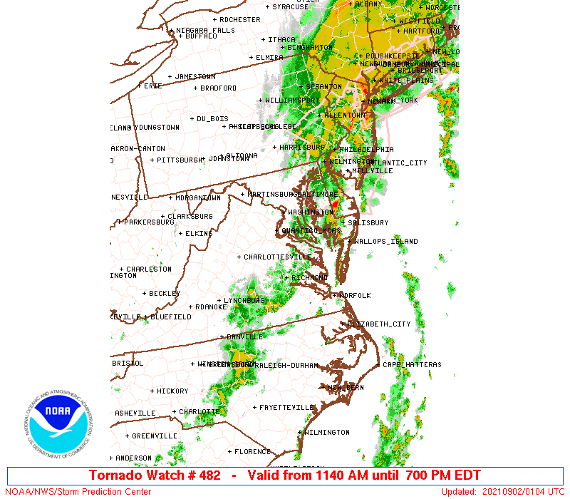
Tornado Watch Number 482
NWS Storm Prediction Center Norman OK
1140 AM EDT Wed Sep 1 2021
The NWS Storm Prediction Center has issued a
* Tornado Watch for portions of
District Of Columbia
Central to eastern Maryland
Far northeast North Carolina
Northern to eastern Virginia
Coastal Waters
* Effective this Wednesday morning and evening from 1140 AM until
700 PM EDT.
* Primary threats include...
A few tornadoes likely
Scattered damaging wind gusts to 70 mph possible
SUMMARY...Several lower-topped supercells should develop within
clusters that spread east-northeast this afternoon.
The tornado watch area is approximately along and 60 statute miles
east and west of a line from 45 miles north northwest of Baltimore
MD to 30 miles southwest of Norfolk VA. For a complete depiction of
the watch see the associated watch outline update (WOUS64 KWNS
WOU2).
PRECAUTIONARY/PREPAREDNESS ACTIONS...
REMEMBER...A Tornado Watch means conditions are favorable for
tornadoes and severe thunderstorms in and close to the watch
area. Persons in these areas should be on the lookout for
threatening weather conditions and listen for later statements
and possible warnings.
&&
AVIATION...Tornadoes and a few severe thunderstorms with hail
surface and aloft to 0.5 inches. Extreme turbulence and surface wind
gusts to 60 knots. A few cumulonimbi with maximum tops to 450. Mean
storm motion vector 24025.
...Grams
 Note:
The Aviation Watch (SAW) product is an approximation to the watch area.
The actual watch is depicted by the shaded areas.
Note:
The Aviation Watch (SAW) product is an approximation to the watch area.
The actual watch is depicted by the shaded areas.
   SAW2
   WW 482 TORNADO DC MD NC VA CW 011540Z - 012300Z
   AXIS..60 STATUTE MILES EAST AND WEST OF LINE..
   45NNW BWI/BALTIMORE MD/ - 30SW ORF/NORFOLK VA/
   ..AVIATION COORDS.. 50NM E/W /17N EMI - 26SW ORF/
   HAIL SURFACE AND ALOFT..0.5 INCH. WIND GUSTS..60 KNOTS.
   MAX TOPS TO 450. MEAN STORM MOTION VECTOR 24025.

   LAT...LON 39787586 36597550 36597766 39787812

   THIS IS AN APPROXIMATION TO THE WATCH AREA.  FOR A
   COMPLETE DEPICTION OF THE WATCH SEE WOUS64 KWNS
   FOR WOU2.
Watch 482 Status Report Messages:
STATUS REPORT #3 ON WW 482

VALID 012015Z - 012140Z

SEVERE WEATHER THREAT CONTINUES RIGHT OF A LINE FROM 10 ENE RZZ
TO 25 S RIC TO 20 NNE RIC TO 40 W NHK TO 10 WSW DCA TO 20 SE HGR
TO 30 ENE HGR.

..JEWELL..09/01/21

ATTN...WFO...LWX...AKQ...

&&

STATUS REPORT FOR WT 482

SEVERE WEATHER THREAT CONTINUES FOR THE FOLLOWING AREAS

DCC001-012140-

DC
.    DISTRICT OF COLUMBIA COUNTIES INCLUDED ARE

DISTRICT OF COLUMBIA
$$


MDC003-005-009-013-015-017-019-021-025-027-031-033-037-039-045-
047-510-012140-

MD
.    MARYLAND COUNTIES INCLUDED ARE

ANNE ARUNDEL	     BALTIMORE		 CALVERT
CARROLL 	     CECIL		 CHARLES
DORCHESTER	     FREDERICK		 HARFORD
HOWARD		     MONTGOMERY 	 PRINCE GEORGES
ST. MARYS	     SOMERSET		 WICOMICO
WORCESTER


MARYLAND INDEPENDENT CITIES INCLUDED ARE

BALTIMORE CITY
$$


NCC073-091-131-012140-

NC
.    NORTH CAROLINA COUNTIES INCLUDED ARE

GATES		     HERTFORD		 NORTHAMPTON
$$


VAC001-013-036-057-073-093-095-097-099-101-103-115-119-127-131-
133-149-159-175-181-183-193-199-510-550-620-650-670-700-710-735-
740-800-810-830-012140-

VA
.    VIRGINIA COUNTIES INCLUDED ARE

ACCOMACK	     ARLINGTON		 CHARLES CITY
ESSEX		     GLOUCESTER 	 ISLE OF WIGHT
JAMES CITY	     KING AND QUEEN	 KING GEORGE
KING WILLIAM	     LANCASTER		 MATHEWS
MIDDLESEX	     NEW KENT		 NORTHAMPTON
NORTHUMBERLAND	     PRINCE GEORGE	 RICHMOND
SOUTHAMPTON	     SURRY		 SUSSEX
WESTMORELAND	     YORK


VIRGINIA INDEPENDENT CITIES INCLUDED ARE

ALEXANDRIA	     CHESAPEAKE 	 FRANKLIN
HAMPTON 	     HOPEWELL		 NEWPORT NEWS
NORFOLK 	     POQUOSON		 PORTSMOUTH
SUFFOLK 	     VIRGINIA BEACH	 WILLIAMSBURG
$$


ANZ530-531-532-533-534-537-538-539-540-541-542-543-630-631-632-
634-635-636-637-638-650-652-654-656-012140-

CW

.    ADJACENT COASTAL WATERS INCLUDED ARE

CHESAPEAKE BAY NORTH OF POOLES ISLAND MD

CHESAPEAKE BAY FROM POOLES ISLAND TO SANDY POINT MD

CHESAPEAKE BAY FROM SANDY POINT TO NORTH BEACH MD

CHESAPEAKE BAY FROM NORTH BEACH TO DRUM POINT MD

CHESAPEAKE BAY FROM DRUM POINT MD TO SMITH POINT VA

TIDAL POTOMAC FROM COBB ISLAND MD TO SMITH POINT VA

PATAPSCO RIVER INCLUDING BALTIMORE HARBOR

CHESTER RIVER TO QUEENSTOWN MD

EASTERN BAY

CHOPTANK RIVER TO CAMBRIDGE MD AND THE LITTLE CHOPTANK RIVER

PATUXENT RIVER TO BROOMES ISLAND MD

TANGIER SOUND AND THE INLAND WATERS SURROUNDING BLOODSWORTH
ISLAND

CHESAPEAKE BAY FROM SMITH POINT TO WINDMILL POINT VA

CHESAPEAKE BAY FROM WINDMILL POINT TO NEW POINT COMFORT VA

CHESAPEAKE BAY FROM NEW POINT COMFORT TO LITTLE CREEK VA

CHESAPEAKE BAY FROM LITTLE CREEK VA TO CAPE HENRY VA INCLUDING
THE CHESAPEAKE BAY BRIDGE TUNNEL

RAPPAHANNOCK RIVER FROM URBANNA TO WINDMILL POINT

YORK RIVER

JAMES RIVER FROM JAMESTOWN TO THE JAMES RIVER BRIDGE

JAMES RIVER FROM JAMES RIVER BRIDGE TO HAMPTON ROADS
BRIDGE-TUNNEL

COASTAL WATERS FROM FENWICK ISLAND DE TO CHINCOTEAGUE VA OUT 20
NM

COASTAL WATERS FROM CHINCOTEAGUE TO PARRAMORE ISLAND VA OUT 20 NM

COASTAL WATERS FROM PARRAMORE ISLAND TO CAPE CHARLES LIGHT VA OUT
20 NM

COASTAL WATERS FROM CAPE CHARLES LIGHT TO VIRGINIA-NORTH CAROLINA
BORDER OUT TO 20 NM

$$
THE WATCH STATUS MESSAGE IS FOR GUIDANCE PURPOSES ONLY.  PLEASE
REFER TO WATCH COUNTY NOTIFICATION STATEMENTS FOR OFFICIAL
INFORMATION ON COUNTIES...INDEPENDENT CITIES AND MARINE ZONES
CLEARED FROM SEVERE THUNDERSTORM AND TORNADO WATCHES.
$$

STATUS REPORT #2 ON WW 482

VALID 011930Z - 012040Z

THE SEVERE WEATHER THREAT CONTINUES ACROSS THE ENTIRE WATCH AREA.

FOR ADDITIONAL INFORMATION SEE MESOSCALE DISCUSSION 1671

..JEWELL..09/01/21

ATTN...WFO...LWX...AKQ...

&&

STATUS REPORT FOR WT 482

SEVERE WEATHER THREAT CONTINUES FOR THE FOLLOWING AREAS

DCC001-012040-

DC
.    DISTRICT OF COLUMBIA COUNTIES INCLUDED ARE

DISTRICT OF COLUMBIA
$$


MDC003-005-009-013-015-017-019-021-025-027-031-033-037-039-045-
047-510-012040-

MD
.    MARYLAND COUNTIES INCLUDED ARE

ANNE ARUNDEL	     BALTIMORE		 CALVERT
CARROLL 	     CECIL		 CHARLES
DORCHESTER	     FREDERICK		 HARFORD
HOWARD		     MONTGOMERY 	 PRINCE GEORGES
ST. MARYS	     SOMERSET		 WICOMICO
WORCESTER


MARYLAND INDEPENDENT CITIES INCLUDED ARE

BALTIMORE CITY
$$


NCC073-091-131-012040-

NC
.    NORTH CAROLINA COUNTIES INCLUDED ARE

GATES		     HERTFORD		 NORTHAMPTON
$$


VAC001-007-013-033-036-041-047-053-057-059-061-073-075-081-085-
087-093-095-097-099-101-103-107-109-115-119-127-131-133-137-145-
149-153-157-159-175-177-179-181-183-193-199-510-550-570-595-600-
610-620-630-650-670-683-685-700-710-730-735-740-760-800-810-830-
012040-

VA
.    VIRGINIA COUNTIES INCLUDED ARE

ACCOMACK	     AMELIA		 ARLINGTON
CAROLINE	     CHARLES CITY	 CHESTERFIELD
CULPEPER	     DINWIDDIE		 ESSEX
FAIRFAX 	     FAUQUIER		 GLOUCESTER
GOOCHLAND	     GREENSVILLE	 HANOVER
HENRICO 	     ISLE OF WIGHT	 JAMES CITY
KING AND QUEEN	     KING GEORGE	 KING WILLIAM
LANCASTER	     LOUDOUN		 LOUISA
MATHEWS 	     MIDDLESEX		 NEW KENT
NORTHAMPTON	     NORTHUMBERLAND	 ORANGE
POWHATAN	     PRINCE GEORGE	 PRINCE WILLIAM
RAPPAHANNOCK	     RICHMOND		 SOUTHAMPTON
SPOTSYLVANIA	     STAFFORD		 SURRY
SUSSEX		     WESTMORELAND	 YORK


VIRGINIA INDEPENDENT CITIES INCLUDED ARE

ALEXANDRIA	     CHESAPEAKE 	 COLONIAL HEIGHTS
EMPORIA 	     FAIRFAX		 FALLS CHURCH
FRANKLIN	     FREDERICKSBURG	 HAMPTON
HOPEWELL	     MANASSAS		 MANASSAS PARK
NEWPORT NEWS	     NORFOLK		 PETERSBURG
POQUOSON	     PORTSMOUTH 	 RICHMOND
SUFFOLK 	     VIRGINIA BEACH	 WILLIAMSBURG
$$


ANZ530-531-532-533-534-535-536-537-538-539-540-541-542-543-630-
631-632-634-635-636-637-638-650-652-654-656-012040-

CW

.    ADJACENT COASTAL WATERS INCLUDED ARE

CHESAPEAKE BAY NORTH OF POOLES ISLAND MD

CHESAPEAKE BAY FROM POOLES ISLAND TO SANDY POINT MD

CHESAPEAKE BAY FROM SANDY POINT TO NORTH BEACH MD

CHESAPEAKE BAY FROM NORTH BEACH TO DRUM POINT MD

CHESAPEAKE BAY FROM DRUM POINT MD TO SMITH POINT VA

TIDAL POTOMAC FROM KEY BRIDGE TO INDIAN HEAD MD

TIDAL POTOMAC FROM INDIAN HEAD TO COBB ISLAND MD

TIDAL POTOMAC FROM COBB ISLAND MD TO SMITH POINT VA

PATAPSCO RIVER INCLUDING BALTIMORE HARBOR

CHESTER RIVER TO QUEENSTOWN MD

EASTERN BAY

CHOPTANK RIVER TO CAMBRIDGE MD AND THE LITTLE CHOPTANK RIVER

PATUXENT RIVER TO BROOMES ISLAND MD

TANGIER SOUND AND THE INLAND WATERS SURROUNDING BLOODSWORTH
ISLAND

CHESAPEAKE BAY FROM SMITH POINT TO WINDMILL POINT VA

CHESAPEAKE BAY FROM WINDMILL POINT TO NEW POINT COMFORT VA

CHESAPEAKE BAY FROM NEW POINT COMFORT TO LITTLE CREEK VA

CHESAPEAKE BAY FROM LITTLE CREEK VA TO CAPE HENRY VA INCLUDING
THE CHESAPEAKE BAY BRIDGE TUNNEL

RAPPAHANNOCK RIVER FROM URBANNA TO WINDMILL POINT

YORK RIVER

JAMES RIVER FROM JAMESTOWN TO THE JAMES RIVER BRIDGE

JAMES RIVER FROM JAMES RIVER BRIDGE TO HAMPTON ROADS
BRIDGE-TUNNEL

COASTAL WATERS FROM FENWICK ISLAND DE TO CHINCOTEAGUE VA OUT 20
NM

COASTAL WATERS FROM CHINCOTEAGUE TO PARRAMORE ISLAND VA OUT 20 NM

COASTAL WATERS FROM PARRAMORE ISLAND TO CAPE CHARLES LIGHT VA OUT
20 NM

COASTAL WATERS FROM CAPE CHARLES LIGHT TO VIRGINIA-NORTH CAROLINA
BORDER OUT TO 20 NM

$$
THE WATCH STATUS MESSAGE IS FOR GUIDANCE PURPOSES ONLY.  PLEASE
REFER TO WATCH COUNTY NOTIFICATION STATEMENTS FOR OFFICIAL
INFORMATION ON COUNTIES...INDEPENDENT CITIES AND MARINE ZONES
CLEARED FROM SEVERE THUNDERSTORM AND TORNADO WATCHES.
$$

STATUS REPORT #1 ON WW 482

VALID 011825Z - 011940Z

THE SEVERE WEATHER THREAT CONTINUES ACROSS THE ENTIRE WATCH AREA.

FOR ADDITIONAL INFORMATION SEE MESOSCALE DISCUSSION 1669

..JEWELL..09/01/21

ATTN...WFO...LWX...AKQ...

&&

STATUS REPORT FOR WT 482

SEVERE WEATHER THREAT CONTINUES FOR THE FOLLOWING AREAS

DCC001-011940-

DC
.    DISTRICT OF COLUMBIA COUNTIES INCLUDED ARE

DISTRICT OF COLUMBIA
$$


MDC003-005-009-013-015-017-019-021-025-027-031-033-037-039-045-
047-510-011940-

MD
.    MARYLAND COUNTIES INCLUDED ARE

ANNE ARUNDEL	     BALTIMORE		 CALVERT
CARROLL 	     CECIL		 CHARLES
DORCHESTER	     FREDERICK		 HARFORD
HOWARD		     MONTGOMERY 	 PRINCE GEORGES
ST. MARYS	     SOMERSET		 WICOMICO
WORCESTER


MARYLAND INDEPENDENT CITIES INCLUDED ARE

BALTIMORE CITY
$$


NCC073-091-131-011940-

NC
.    NORTH CAROLINA COUNTIES INCLUDED ARE

GATES		     HERTFORD		 NORTHAMPTON
$$


VAC001-007-013-033-036-041-047-053-057-059-061-073-075-081-085-
087-093-095-097-099-101-103-107-109-115-119-127-131-133-137-145-
149-153-157-159-175-177-179-181-183-193-199-510-550-570-595-600-
610-620-630-650-670-683-685-700-710-730-735-740-760-800-810-830-
011940-

VA
.    VIRGINIA COUNTIES INCLUDED ARE

ACCOMACK	     AMELIA		 ARLINGTON
CAROLINE	     CHARLES CITY	 CHESTERFIELD
CULPEPER	     DINWIDDIE		 ESSEX
FAIRFAX 	     FAUQUIER		 GLOUCESTER
GOOCHLAND	     GREENSVILLE	 HANOVER
HENRICO 	     ISLE OF WIGHT	 JAMES CITY
KING AND QUEEN	     KING GEORGE	 KING WILLIAM
LANCASTER	     LOUDOUN		 LOUISA
MATHEWS 	     MIDDLESEX		 NEW KENT
NORTHAMPTON	     NORTHUMBERLAND	 ORANGE
POWHATAN	     PRINCE GEORGE	 PRINCE WILLIAM
RAPPAHANNOCK	     RICHMOND		 SOUTHAMPTON
SPOTSYLVANIA	     STAFFORD		 SURRY
SUSSEX		     WESTMORELAND	 YORK


VIRGINIA INDEPENDENT CITIES INCLUDED ARE

ALEXANDRIA	     CHESAPEAKE 	 COLONIAL HEIGHTS
EMPORIA 	     FAIRFAX		 FALLS CHURCH
FRANKLIN	     FREDERICKSBURG	 HAMPTON
HOPEWELL	     MANASSAS		 MANASSAS PARK
NEWPORT NEWS	     NORFOLK		 PETERSBURG
POQUOSON	     PORTSMOUTH 	 RICHMOND
SUFFOLK 	     VIRGINIA BEACH	 WILLIAMSBURG
$$


ANZ530-531-532-533-534-535-536-537-538-539-540-541-542-543-630-
631-632-634-635-636-637-638-650-652-654-656-011940-

CW

.    ADJACENT COASTAL WATERS INCLUDED ARE

CHESAPEAKE BAY NORTH OF POOLES ISLAND MD

CHESAPEAKE BAY FROM POOLES ISLAND TO SANDY POINT MD

CHESAPEAKE BAY FROM SANDY POINT TO NORTH BEACH MD

CHESAPEAKE BAY FROM NORTH BEACH TO DRUM POINT MD

CHESAPEAKE BAY FROM DRUM POINT MD TO SMITH POINT VA

TIDAL POTOMAC FROM KEY BRIDGE TO INDIAN HEAD MD

TIDAL POTOMAC FROM INDIAN HEAD TO COBB ISLAND MD

TIDAL POTOMAC FROM COBB ISLAND MD TO SMITH POINT VA

PATAPSCO RIVER INCLUDING BALTIMORE HARBOR

CHESTER RIVER TO QUEENSTOWN MD

EASTERN BAY

CHOPTANK RIVER TO CAMBRIDGE MD AND THE LITTLE CHOPTANK RIVER

PATUXENT RIVER TO BROOMES ISLAND MD

TANGIER SOUND AND THE INLAND WATERS SURROUNDING BLOODSWORTH
ISLAND

CHESAPEAKE BAY FROM SMITH POINT TO WINDMILL POINT VA

CHESAPEAKE BAY FROM WINDMILL POINT TO NEW POINT COMFORT VA

CHESAPEAKE BAY FROM NEW POINT COMFORT TO LITTLE CREEK VA

CHESAPEAKE BAY FROM LITTLE CREEK VA TO CAPE HENRY VA INCLUDING
THE CHESAPEAKE BAY BRIDGE TUNNEL

RAPPAHANNOCK RIVER FROM URBANNA TO WINDMILL POINT

YORK RIVER

JAMES RIVER FROM JAMESTOWN TO THE JAMES RIVER BRIDGE

JAMES RIVER FROM JAMES RIVER BRIDGE TO HAMPTON ROADS
BRIDGE-TUNNEL

COASTAL WATERS FROM FENWICK ISLAND DE TO CHINCOTEAGUE VA OUT 20
NM

COASTAL WATERS FROM CHINCOTEAGUE TO PARRAMORE ISLAND VA OUT 20 NM

COASTAL WATERS FROM PARRAMORE ISLAND TO CAPE CHARLES LIGHT VA OUT
20 NM

COASTAL WATERS FROM CAPE CHARLES LIGHT TO VIRGINIA-NORTH CAROLINA
BORDER OUT TO 20 NM

$$
THE WATCH STATUS MESSAGE IS FOR GUIDANCE PURPOSES ONLY.  PLEASE
REFER TO WATCH COUNTY NOTIFICATION STATEMENTS FOR OFFICIAL
INFORMATION ON COUNTIES...INDEPENDENT CITIES AND MARINE ZONES
CLEARED FROM SEVERE THUNDERSTORM AND TORNADO WATCHES.
$$
Note:
Click for Complete Product Text.
Tornadoes
Probability of 2 or more tornadoes
|
Mod (60%)
|
Probability of 1 or more strong (EF2-EF5) tornadoes
|
Low (20%)
|
Wind
Probability of 10 or more severe wind events
|
Mod (50%)
|
Probability of 1 or more wind events > 65 knots
|
Low (20%)
|
Hail
Probability of 10 or more severe hail events
|
Low (<5%)
|
Probability of 1 or more hailstones > 2 inches
|
Low (<5%)
|
Combined Severe Hail/Wind
Probability of 6 or more combined severe hail/wind events
|
Mod (60%)
|
For each watch, probabilities for particular events inside the watch
(listed above in each table) are determined by the issuing forecaster.
The "Low" category contains probability values ranging from less than 2%
to 20% (EF2-EF5 tornadoes), less than 5% to 20% (all other probabilities),
"Moderate" from 30% to 60%, and "High" from 70% to greater than 95%.
High values are bolded and lighter in color to provide awareness of
an increased threat for a particular event.


 @NWSSPC