Note:
The expiration time in the watch graphic is amended if the watch is
replaced, cancelled or extended.
Note:
Note:
The expiration time in the watch graphic is amended if the watch is
replaced, cancelled or extended.
Note: Click for
Watch Status Reports.
SEL1
URGENT - IMMEDIATE BROADCAST REQUESTED
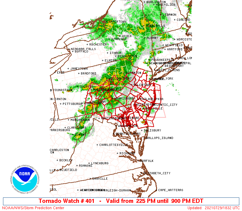
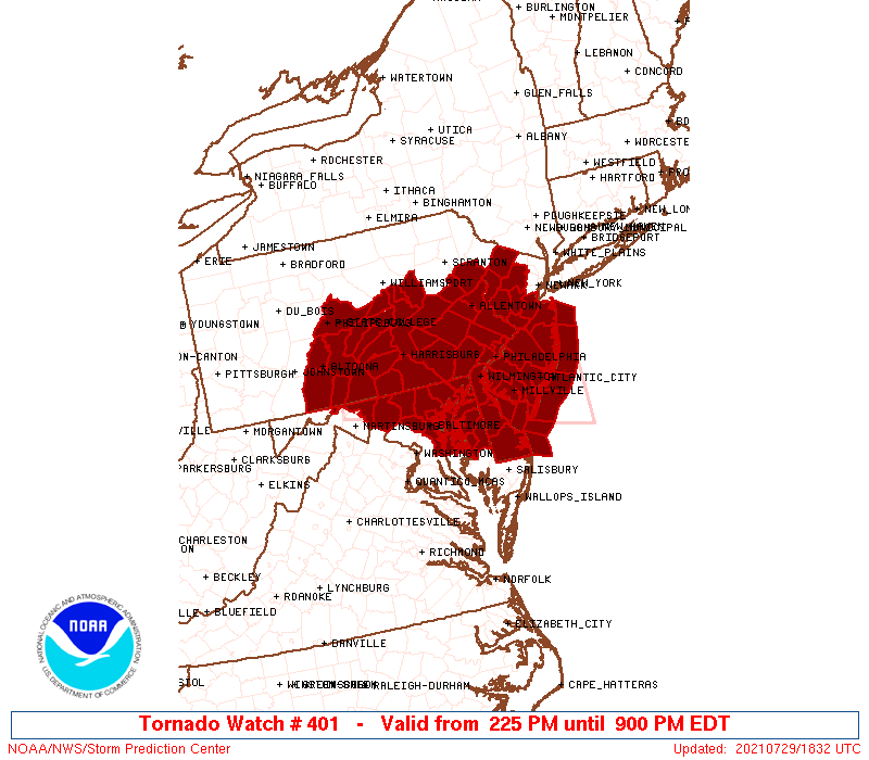
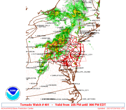
Tornado Watch Number 401
NWS Storm Prediction Center Norman OK
225 PM EDT Thu Jul 29 2021
The NWS Storm Prediction Center has issued a
* Tornado Watch for portions of
Delaware
Central and Eastern Maryland
Much of New Jersey
Central and Southeast Pennsylvania
Coastal Waters
* Effective this Thursday afternoon and evening from 225 PM until
900 PM EDT.
* Primary threats include...
A couple tornadoes possible
Scattered damaging wind gusts to 70 mph likely
Isolated large hail events to 1.5 inches in diameter possible
SUMMARY...Thunderstorms over central Pennsylvania will intensify as
they move eastward, while isolated storms form out ahead of the main
activity. A few supercells and bowing lines are expected, capable
of damaging winds, hail, and perhaps a few tornadoes.
The tornado watch area is approximately along and 55 statute miles
north and south of a line from 40 miles south southwest of State
College PA to 40 miles east of Atlantic City NJ. For a complete
depiction of the watch see the associated watch outline update
(WOUS64 KWNS WOU1).
PRECAUTIONARY/PREPAREDNESS ACTIONS...
REMEMBER...A Tornado Watch means conditions are favorable for
tornadoes and severe thunderstorms in and close to the watch
area. Persons in these areas should be on the lookout for
threatening weather conditions and listen for later statements
and possible warnings.
&&
AVIATION...Tornadoes and a few severe thunderstorms with hail
surface and aloft to 1.5 inches. Extreme turbulence and surface wind
gusts to 60 knots. A few cumulonimbi with maximum tops to 500. Mean
storm motion vector 27035.
...Hart
   SEL1

   URGENT - IMMEDIATE BROADCAST REQUESTED
   Tornado Watch Number 401
   NWS Storm Prediction Center Norman OK
   225 PM EDT Thu Jul 29 2021

   The NWS Storm Prediction Center has issued a

   * Tornado Watch for portions of
     Delaware
     Central and Eastern Maryland
     Much of New Jersey
     Central and Southeast Pennsylvania
     Coastal Waters

   * Effective this Thursday afternoon and evening from 225 PM until
     900 PM EDT.

   * Primary threats include...
     A couple tornadoes possible
     Scattered damaging wind gusts to 70 mph likely
     Isolated large hail events to 1.5 inches in diameter possible

   SUMMARY...Thunderstorms over central Pennsylvania will intensify as
   they move eastward, while isolated storms form out ahead of the main
   activity.  A few supercells and bowing lines are expected, capable
   of damaging winds, hail, and perhaps a few tornadoes.

   The tornado watch area is approximately along and 55 statute miles
   north and south of a line from 40 miles south southwest of State
   College PA to 40 miles east of Atlantic City NJ. For a complete
   depiction of the watch see the associated watch outline update
   (WOUS64 KWNS WOU1).

   PRECAUTIONARY/PREPAREDNESS ACTIONS...

   REMEMBER...A Tornado Watch means conditions are favorable for
   tornadoes and severe thunderstorms in and close to the watch
   area. Persons in these areas should be on the lookout for
   threatening weather conditions and listen for later statements
   and possible warnings.

   &&

   AVIATION...Tornadoes and a few severe thunderstorms with hail
   surface and aloft to 1.5 inches. Extreme turbulence and surface wind
   gusts to 60 knots. A few cumulonimbi with maximum tops to 500. Mean
   storm motion vector 27035.

   ...Hart
 Note:
The Aviation Watch (SAW) product is an approximation to the watch area.
The actual watch is depicted by the shaded areas.
Note:
The Aviation Watch (SAW) product is an approximation to the watch area.
The actual watch is depicted by the shaded areas.
   SAW1
   WW 401 TORNADO DE MD NJ PA CW 291825Z - 300100Z
   AXIS..55 STATUTE MILES NORTH AND SOUTH OF LINE..
   40SSW UNV/STATE COLLEGE PA/ - 40E ACY/ATLANTIC CITY NJ/
   ..AVIATION COORDS.. 50NM N/S /32E JST - 36SE CYN/
   HAIL SURFACE AND ALOFT..1.5 INCHES. WIND GUSTS..60 KNOTS.
   MAX TOPS TO 500. MEAN STORM MOTION VECTOR 27035.

   LAT...LON 41117814 40247383 38657383 39527814

   THIS IS AN APPROXIMATION TO THE WATCH AREA.  FOR A
   COMPLETE DEPICTION OF THE WATCH SEE WOUS64 KWNS
   FOR WOU1.
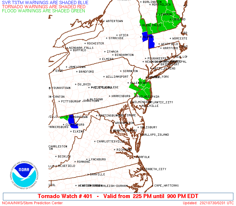
Watch 401 Status Report Messages:
STATUS REPORT #4 ON WW 401

VALID 300030Z - 300140Z

SEVERE WEATHER THREAT CONTINUES RIGHT OF A LINE FROM 55 SE ACY TO
5 SSE ILG TO 20 WNW TTN TO 25 W EWR TO 30 SE JFK.

FOR ADDITIONAL INFORMATION SEE MESOSCALE DISCUSSION 1394

..MOORE..07/30/21

ATTN...WFO...PHI...LWX...CTP...

&&

STATUS REPORT FOR WT 401

SEVERE WEATHER THREAT CONTINUES FOR THE FOLLOWING AREAS

NJC001-005-007-015-021-023-025-029-033-035-300140-

NJ
.    NEW JERSEY COUNTIES INCLUDED ARE

ATLANTIC	     BURLINGTON 	 CAMDEN
GLOUCESTER	     MERCER		 MIDDLESEX
MONMOUTH	     OCEAN		 SALEM
SOMERSET
$$


PAC017-045-101-300140-

PA
.    PENNSYLVANIA COUNTIES INCLUDED ARE

BUCKS		     DELAWARE		 PHILADELPHIA
$$


ANZ450-451-452-300140-

CW

.    ADJACENT COASTAL WATERS INCLUDED ARE

COASTAL WATERS FROM SANDY HOOK TO MANASQUAN INLET NJ OUT 20 NM

COASTAL WATERS FROM MANASQUAN INLET TO LITTLE EGG INLET NJ OUT 20
NM

COASTAL WATERS FROM LITTLE EGG INLET TO GREAT EGG INLET NJ OUT 20
NM

$$
THE WATCH STATUS MESSAGE IS FOR GUIDANCE PURPOSES ONLY.  PLEASE
REFER TO WATCH COUNTY NOTIFICATION STATEMENTS FOR OFFICIAL
INFORMATION ON COUNTIES...INDEPENDENT CITIES AND MARINE ZONES
CLEARED FROM SEVERE THUNDERSTORM AND TORNADO WATCHES.
$$

STATUS REPORT #3 ON WW 401

VALID 292345Z - 300040Z

SEVERE WEATHER THREAT CONTINUES RIGHT OF A LINE FROM 30 E SBY TO
15 SSE ILG TO 10 NW PHL TO 15 S MSV.

FOR ADDITIONAL INFORMATION SEE MESOSCALE DISCUSSION 1393

..MOORE..07/29/21

ATTN...WFO...PHI...LWX...CTP...

&&

STATUS REPORT FOR WT 401

SEVERE WEATHER THREAT CONTINUES FOR THE FOLLOWING AREAS

NJC001-005-007-009-011-015-019-021-023-025-027-029-033-035-037-
041-300040-

NJ
.    NEW JERSEY COUNTIES INCLUDED ARE

ATLANTIC	     BURLINGTON 	 CAMDEN
CAPE MAY	     CUMBERLAND 	 GLOUCESTER
HUNTERDON	     MERCER		 MIDDLESEX
MONMOUTH	     MORRIS		 OCEAN
SALEM		     SOMERSET		 SUSSEX
WARREN
$$


PAC017-045-101-300040-

PA
.    PENNSYLVANIA COUNTIES INCLUDED ARE

BUCKS		     DELAWARE		 PHILADELPHIA
$$


ANZ431-450-451-452-453-454-455-300040-

CW

.    ADJACENT COASTAL WATERS INCLUDED ARE

DELAWARE BAY WATERS SOUTH OF EAST POINT NJ TO SLAUGHTER BEACH DE

COASTAL WATERS FROM SANDY HOOK TO MANASQUAN INLET NJ OUT 20 NM

COASTAL WATERS FROM MANASQUAN INLET TO LITTLE EGG INLET NJ OUT 20
NM

COASTAL WATERS FROM LITTLE EGG INLET TO GREAT EGG INLET NJ OUT 20
NM

COASTAL WATERS FROM GREAT EGG INLET TO CAPE MAY NJ OUT 20 NM

COASTAL WATERS FROM CAPE MAY NJ TO CAPE HENLOPEN DE OUT 20 NM

COASTAL WATERS FROM CAPE HENLOPEN TO FENWICK ISLAND DE OUT 20 NM

$$
THE WATCH STATUS MESSAGE IS FOR GUIDANCE PURPOSES ONLY.  PLEASE
REFER TO WATCH COUNTY NOTIFICATION STATEMENTS FOR OFFICIAL
INFORMATION ON COUNTIES...INDEPENDENT CITIES AND MARINE ZONES
CLEARED FROM SEVERE THUNDERSTORM AND TORNADO WATCHES.
$$

STATUS REPORT #2 ON WW 401

VALID 292245Z - 292340Z

SEVERE WEATHER THREAT CONTINUES RIGHT OF A LINE FROM 20 ESE MRB
TO 15 SW AVP.

..MOORE..07/29/21

ATTN...WFO...PHI...LWX...CTP...

&&

STATUS REPORT FOR WT 401

SEVERE WEATHER THREAT CONTINUES FOR THE FOLLOWING AREAS

DEC001-003-005-292340-

DE
.    DELAWARE COUNTIES INCLUDED ARE

KENT		     NEW CASTLE 	 SUSSEX
$$


MDC003-005-011-013-015-025-027-029-035-041-510-292340-

MD
.    MARYLAND COUNTIES INCLUDED ARE

ANNE ARUNDEL	     BALTIMORE		 CAROLINE
CARROLL 	     CECIL		 HARFORD
HOWARD		     KENT		 QUEEN ANNE'S
TALBOT


MARYLAND INDEPENDENT CITIES INCLUDED ARE

BALTIMORE CITY
$$


NJC001-005-007-009-011-015-019-021-023-025-027-029-033-035-037-
041-292340-

NJ
.    NEW JERSEY COUNTIES INCLUDED ARE

ATLANTIC	     BURLINGTON 	 CAMDEN
CAPE MAY	     CUMBERLAND 	 GLOUCESTER
HUNTERDON	     MERCER		 MIDDLESEX
MONMOUTH	     MORRIS		 OCEAN
SALEM		     SOMERSET		 SUSSEX
WARREN
$$


PAC011-017-025-029-045-071-075-077-089-091-095-101-107-133-
292340-

PA
.    PENNSYLVANIA COUNTIES INCLUDED ARE

BERKS		     BUCKS		 CARBON
CHESTER 	     DELAWARE		 LANCASTER
LEBANON 	     LEHIGH		 MONROE
MONTGOMERY	     NORTHAMPTON	 PHILADELPHIA
SCHUYLKILL	     YORK
$$


ANZ430-431-450-451-452-453-454-455-530-531-532-538-539-540-
292340-

CW

.    ADJACENT COASTAL WATERS INCLUDED ARE

DELAWARE BAY WATERS NORTH OF EAST POINT NJ TO SLAUGHTER BEACH DE

DELAWARE BAY WATERS SOUTH OF EAST POINT NJ TO SLAUGHTER BEACH DE

COASTAL WATERS FROM SANDY HOOK TO MANASQUAN INLET NJ OUT 20 NM

COASTAL WATERS FROM MANASQUAN INLET TO LITTLE EGG INLET NJ OUT 20
NM

COASTAL WATERS FROM LITTLE EGG INLET TO GREAT EGG INLET NJ OUT 20
NM

COASTAL WATERS FROM GREAT EGG INLET TO CAPE MAY NJ OUT 20 NM

COASTAL WATERS FROM CAPE MAY NJ TO CAPE HENLOPEN DE OUT 20 NM

COASTAL WATERS FROM CAPE HENLOPEN TO FENWICK ISLAND DE OUT 20 NM

CHESAPEAKE BAY NORTH OF POOLES ISLAND MD

CHESAPEAKE BAY FROM POOLES ISLAND TO SANDY POINT MD

CHESAPEAKE BAY FROM SANDY POINT TO NORTH BEACH MD

PATAPSCO RIVER INCLUDING BALTIMORE HARBOR

CHESTER RIVER TO QUEENSTOWN MD

EASTERN BAY

$$
THE WATCH STATUS MESSAGE IS FOR GUIDANCE PURPOSES ONLY.  PLEASE
REFER TO WATCH COUNTY NOTIFICATION STATEMENTS FOR OFFICIAL
INFORMATION ON COUNTIES...INDEPENDENT CITIES AND MARINE ZONES
CLEARED FROM SEVERE THUNDERSTORM AND TORNADO WATCHES.
$$

STATUS REPORT #1 ON WW 401

VALID 292200Z - 292340Z

SEVERE WEATHER THREAT CONTINUES RIGHT OF A LINE FROM 25 SE MRB TO
25 ESE HGR TO 5 E CXY TO 5 E AVP.

FOR ADDITIONAL INFORMATION SEE MESOSCALE DISCUSSION 1391

..MOORE..07/29/21

ATTN...WFO...PHI...LWX...CTP...

&&

STATUS REPORT FOR WT 401

SEVERE WEATHER THREAT CONTINUES FOR THE FOLLOWING AREAS

DEC001-003-005-292340-

DE
.    DELAWARE COUNTIES INCLUDED ARE

KENT		     NEW CASTLE 	 SUSSEX
$$


MDC003-005-011-013-015-025-027-029-035-041-510-292340-

MD
.    MARYLAND COUNTIES INCLUDED ARE

ANNE ARUNDEL	     BALTIMORE		 CAROLINE
CARROLL 	     CECIL		 HARFORD
HOWARD		     KENT		 QUEEN ANNE'S
TALBOT


MARYLAND INDEPENDENT CITIES INCLUDED ARE

BALTIMORE CITY
$$


NJC001-005-007-009-011-015-019-021-023-025-027-029-033-035-037-
041-292340-

NJ
.    NEW JERSEY COUNTIES INCLUDED ARE

ATLANTIC	     BURLINGTON 	 CAMDEN
CAPE MAY	     CUMBERLAND 	 GLOUCESTER
HUNTERDON	     MERCER		 MIDDLESEX
MONMOUTH	     MORRIS		 OCEAN
SALEM		     SOMERSET		 SUSSEX
WARREN
$$


PAC011-017-025-029-045-071-075-077-089-091-095-101-107-133-
292340-

PA
.    PENNSYLVANIA COUNTIES INCLUDED ARE

BERKS		     BUCKS		 CARBON
CHESTER 	     DELAWARE		 LANCASTER
LEBANON 	     LEHIGH		 MONROE
MONTGOMERY	     NORTHAMPTON	 PHILADELPHIA
SCHUYLKILL	     YORK
$$


ANZ430-431-450-451-452-453-454-455-530-531-532-538-539-540-
292340-

CW

.    ADJACENT COASTAL WATERS INCLUDED ARE

DELAWARE BAY WATERS NORTH OF EAST POINT NJ TO SLAUGHTER BEACH DE

DELAWARE BAY WATERS SOUTH OF EAST POINT NJ TO SLAUGHTER BEACH DE

COASTAL WATERS FROM SANDY HOOK TO MANASQUAN INLET NJ OUT 20 NM

COASTAL WATERS FROM MANASQUAN INLET TO LITTLE EGG INLET NJ OUT 20
NM

COASTAL WATERS FROM LITTLE EGG INLET TO GREAT EGG INLET NJ OUT 20
NM

COASTAL WATERS FROM GREAT EGG INLET TO CAPE MAY NJ OUT 20 NM

COASTAL WATERS FROM CAPE MAY NJ TO CAPE HENLOPEN DE OUT 20 NM

COASTAL WATERS FROM CAPE HENLOPEN TO FENWICK ISLAND DE OUT 20 NM

CHESAPEAKE BAY NORTH OF POOLES ISLAND MD

CHESAPEAKE BAY FROM POOLES ISLAND TO SANDY POINT MD

CHESAPEAKE BAY FROM SANDY POINT TO NORTH BEACH MD

PATAPSCO RIVER INCLUDING BALTIMORE HARBOR

CHESTER RIVER TO QUEENSTOWN MD

EASTERN BAY

$$
THE WATCH STATUS MESSAGE IS FOR GUIDANCE PURPOSES ONLY.  PLEASE
REFER TO WATCH COUNTY NOTIFICATION STATEMENTS FOR OFFICIAL
INFORMATION ON COUNTIES...INDEPENDENT CITIES AND MARINE ZONES
CLEARED FROM SEVERE THUNDERSTORM AND TORNADO WATCHES.
$$
Note:
Click for Complete Product Text.
Tornadoes
Probability of 2 or more tornadoes
|
Mod (40%)
|
Probability of 1 or more strong (EF2-EF5) tornadoes
|
Low (20%)
|
Wind
Probability of 10 or more severe wind events
|
Mod (60%)
|
Probability of 1 or more wind events > 65 knots
|
Low (20%)
|
Hail
Probability of 10 or more severe hail events
|
Low (20%)
|
Probability of 1 or more hailstones > 2 inches
|
Low (10%)
|
Combined Severe Hail/Wind
Probability of 6 or more combined severe hail/wind events
|
High (80%)
|
For each watch, probabilities for particular events inside the watch
(listed above in each table) are determined by the issuing forecaster.
The "Low" category contains probability values ranging from less than 2%
to 20% (EF2-EF5 tornadoes), less than 5% to 20% (all other probabilities),
"Moderate" from 30% to 60%, and "High" from 70% to greater than 95%.
High values are bolded and lighter in color to provide awareness of
an increased threat for a particular event.


 @NWSSPC