Note:
The expiration time in the watch graphic is amended if the watch is
replaced, cancelled or extended.
Note:
Note:
The expiration time in the watch graphic is amended if the watch is
replaced, cancelled or extended.
Note: Click for
Watch Status Reports.
SEL0
URGENT - IMMEDIATE BROADCAST REQUESTED
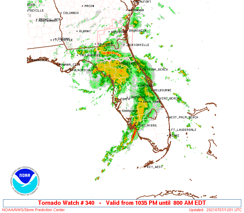
Tornado Watch Number 340
NWS Storm Prediction Center Norman OK
1035 PM EDT Tue Jul 6 2021
The NWS Storm Prediction Center has issued a
* Tornado Watch for portions of
Central and Western Florida Peninsula
Coastal Waters
* Effective this Tuesday night and Wednesday morning from 1035 PM
until 800 AM EDT.
* Primary threats include...
A couple tornadoes possible
Isolated damaging wind gusts to 70 mph possible
SUMMARY...Hurricane Elsa continues to track northward off the west
coast of Florida. Shear profiles are favorable for a risk of a few
tornadoes overnight in the rainbands associated with the hurricane.
The tornado watch area is approximately along and 55 statute miles
east and west of a line from 35 miles east of Cross City FL to 30
miles south southeast of Naples FL. For a complete depiction of the
watch see the associated watch outline update (WOUS64 KWNS WOU0).
PRECAUTIONARY/PREPAREDNESS ACTIONS...
REMEMBER...A Tornado Watch means conditions are favorable for
tornadoes and severe thunderstorms in and close to the watch
area. Persons in these areas should be on the lookout for
threatening weather conditions and listen for later statements
and possible warnings.
&&
OTHER WATCH INFORMATION...CONTINUE...WW 337...WW 338...WW 339...
AVIATION...Tornadoes and a few severe thunderstorms with hail
surface and aloft to 0.5 inches. Extreme turbulence and surface wind
gusts to 60 knots. A few cumulonimbi with maximum tops to 500. Mean
storm motion vector 18030.
...Hart
 Note:
The Aviation Watch (SAW) product is an approximation to the watch area.
The actual watch is depicted by the shaded areas.
Note:
The Aviation Watch (SAW) product is an approximation to the watch area.
The actual watch is depicted by the shaded areas.
   SAW0
   WW 340 TORNADO FL CW 070235Z - 071200Z
   AXIS..55 STATUTE MILES EAST AND WEST OF LINE..
   35E CTY/CROSS CITY FL/ - 30SSE APF/NAPLES FL/
   ..AVIATION COORDS.. 50NM E/W /28E CTY - 48SSE RSW/
   HAIL SURFACE AND ALOFT..0.5 INCH. WIND GUSTS..60 KNOTS.
   MAX TOPS TO 500. MEAN STORM MOTION VECTOR 18030.

   LAT...LON 29638160 25758069 25758247 29638343

   THIS IS AN APPROXIMATION TO THE WATCH AREA.  FOR A
   COMPLETE DEPICTION OF THE WATCH SEE WOUS64 KWNS
   FOR WOU0.
Watch 340 Status Report Messages:
STATUS REPORT #3 ON WW 340

VALID 070855Z - 070940Z

SEVERE WEATHER THREAT CONTINUES RIGHT OF A LINE FROM 30 SSW APF
TO 25 SE AGR.

..GOSS..07/07/21

ATTN...WFO...TBW...MFL...MLB...JAX...

&&

STATUS REPORT FOR WT 340

SEVERE WEATHER THREAT CONTINUES FOR THE FOLLOWING AREAS

FLC015-017-027-049-053-055-057-069-071-075-081-083-095-097-101-
103-105-115-117-119-127-070940-

FL
.    FLORIDA COUNTIES INCLUDED ARE

CHARLOTTE	     CITRUS		 DESOTO
HARDEE		     HERNANDO		 HIGHLANDS
HILLSBOROUGH	     LAKE		 LEE
LEVY		     MANATEE		 MARION
ORANGE		     OSCEOLA		 PASCO
PINELLAS	     POLK		 SARASOTA
SEMINOLE	     SUMTER		 VOLUSIA
$$


GMZ830-836-850-853-856-070940-

CW

.    ADJACENT COASTAL WATERS INCLUDED ARE

TAMPA BAY WATERS

CHARLOTTE HARBOR AND PINE ISLAND SOUND

COASTAL WATERS FROM TARPON SPRINGS TO SUWANNEE RIVER FL OUT 20 NM

COASTAL WATERS FROM ENGLEWOOD TO TARPON SPRINGS FL OUT 20 NM

COASTAL WATERS FROM BONITA BEACH TO ENGLEWOOD FL OUT 20 NM

$$
THE WATCH STATUS MESSAGE IS FOR GUIDANCE PURPOSES ONLY.  PLEASE
REFER TO WATCH COUNTY NOTIFICATION STATEMENTS FOR OFFICIAL
INFORMATION ON COUNTIES...INDEPENDENT CITIES AND MARINE ZONES
CLEARED FROM SEVERE THUNDERSTORM AND TORNADO WATCHES.
$$

STATUS REPORT #2 ON WW 340

VALID 070755Z - 070840Z

SEVERE WEATHER THREAT CONTINUES RIGHT OF A LINE FROM 30 SSW APF
TO 50 W PBI.

..GOSS..07/07/21

ATTN...WFO...TBW...MFL...MLB...JAX...

&&

STATUS REPORT FOR WT 340

SEVERE WEATHER THREAT CONTINUES FOR THE FOLLOWING AREAS

FLC015-017-027-043-049-051-053-055-057-069-071-075-081-083-093-
095-097-101-103-105-115-117-119-127-070840-

FL
.    FLORIDA COUNTIES INCLUDED ARE

CHARLOTTE	     CITRUS		 DESOTO
GLADES		     HARDEE		 HENDRY
HERNANDO	     HIGHLANDS		 HILLSBOROUGH
LAKE		     LEE		 LEVY
MANATEE 	     MARION		 OKEECHOBEE
ORANGE		     OSCEOLA		 PASCO
PINELLAS	     POLK		 SARASOTA
SEMINOLE	     SUMTER		 VOLUSIA
$$


AMZ610-GMZ830-836-850-853-856-070840-

CW

.    ADJACENT COASTAL WATERS INCLUDED ARE

LAKE OKEECHOBEE

TAMPA BAY WATERS

CHARLOTTE HARBOR AND PINE ISLAND SOUND

COASTAL WATERS FROM TARPON SPRINGS TO SUWANNEE RIVER FL OUT 20 NM

COASTAL WATERS FROM ENGLEWOOD TO TARPON SPRINGS FL OUT 20 NM

COASTAL WATERS FROM BONITA BEACH TO ENGLEWOOD FL OUT 20 NM

$$
THE WATCH STATUS MESSAGE IS FOR GUIDANCE PURPOSES ONLY.  PLEASE
REFER TO WATCH COUNTY NOTIFICATION STATEMENTS FOR OFFICIAL
INFORMATION ON COUNTIES...INDEPENDENT CITIES AND MARINE ZONES
CLEARED FROM SEVERE THUNDERSTORM AND TORNADO WATCHES.
$$

STATUS REPORT #1 ON WW 340

VALID 070530Z - 070640Z

THE SEVERE WEATHER THREAT CONTINUES ACROSS THE ENTIRE WATCH AREA.

..GOSS..07/07/21

ATTN...WFO...TBW...MFL...MLB...JAX...

&&

STATUS REPORT FOR WT 340

SEVERE WEATHER THREAT CONTINUES FOR THE FOLLOWING AREAS

FLC015-017-021-027-043-049-051-053-055-057-069-071-075-081-083-
093-095-097-101-103-105-115-117-119-127-070640-

FL
.    FLORIDA COUNTIES INCLUDED ARE

CHARLOTTE	     CITRUS		 COLLIER
DESOTO		     GLADES		 HARDEE
HENDRY		     HERNANDO		 HIGHLANDS
HILLSBOROUGH	     LAKE		 LEE
LEVY		     MANATEE		 MARION
OKEECHOBEE	     ORANGE		 OSCEOLA
PASCO		     PINELLAS		 POLK
SARASOTA	     SEMINOLE		 SUMTER
VOLUSIA
$$


AMZ610-GMZ656-830-836-850-853-856-070640-

CW

.    ADJACENT COASTAL WATERS INCLUDED ARE

LAKE OKEECHOBEE

COASTAL WATERS FROM CHOKOLOSKEE TO BONITA BEACH FL OUT 20 NM

TAMPA BAY WATERS

CHARLOTTE HARBOR AND PINE ISLAND SOUND

COASTAL WATERS FROM TARPON SPRINGS TO SUWANNEE RIVER FL OUT 20 NM

COASTAL WATERS FROM ENGLEWOOD TO TARPON SPRINGS FL OUT 20 NM

COASTAL WATERS FROM BONITA BEACH TO ENGLEWOOD FL OUT 20 NM

$$
THE WATCH STATUS MESSAGE IS FOR GUIDANCE PURPOSES ONLY.  PLEASE
REFER TO WATCH COUNTY NOTIFICATION STATEMENTS FOR OFFICIAL
INFORMATION ON COUNTIES...INDEPENDENT CITIES AND MARINE ZONES
CLEARED FROM SEVERE THUNDERSTORM AND TORNADO WATCHES.
$$
Note:
Click for Complete Product Text.
Tornadoes
Probability of 2 or more tornadoes
|
Mod (40%)
|
Probability of 1 or more strong (EF2-EF5) tornadoes
|
Low (20%)
|
Wind
Probability of 10 or more severe wind events
|
Low (20%)
|
Probability of 1 or more wind events > 65 knots
|
Low (10%)
|
Hail
Probability of 10 or more severe hail events
|
Low (<5%)
|
Probability of 1 or more hailstones > 2 inches
|
Low (<5%)
|
Combined Severe Hail/Wind
Probability of 6 or more combined severe hail/wind events
|
Mod (30%)
|
For each watch, probabilities for particular events inside the watch
(listed above in each table) are determined by the issuing forecaster.
The "Low" category contains probability values ranging from less than 2%
to 20% (EF2-EF5 tornadoes), less than 5% to 20% (all other probabilities),
"Moderate" from 30% to 60%, and "High" from 70% to greater than 95%.
High values are bolded and lighter in color to provide awareness of
an increased threat for a particular event.


 @NWSSPC