Note:
The expiration time in the watch graphic is amended if the watch is
replaced, cancelled or extended.
Note:
Note:
The expiration time in the watch graphic is amended if the watch is
replaced, cancelled or extended.
Note: Click for
Watch Status Reports.
SEL1
URGENT - IMMEDIATE BROADCAST REQUESTED
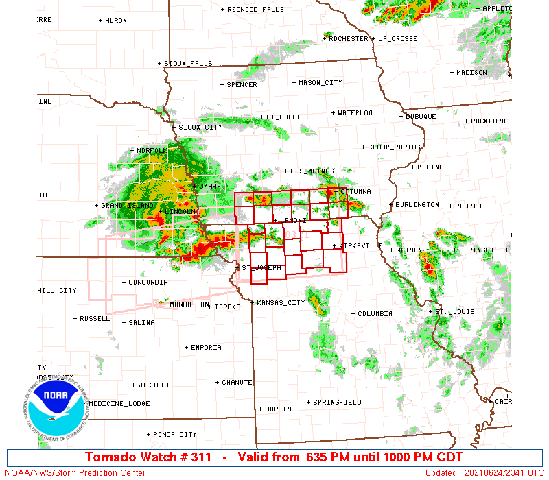
Tornado Watch Number 311
NWS Storm Prediction Center Norman OK
635 PM CDT Thu Jun 24 2021
The NWS Storm Prediction Center has issued a
* Tornado Watch for portions of
Southern Iowa
Northern Missouri
* Effective this Thursday evening from 635 PM until 1000 PM CDT.
* Primary threats include...
A couple tornadoes possible
Scattered damaging winds likely with isolated significant gusts
to 80 mph possible
Isolated very large hail events to 2 inches in diameter possible
SUMMARY...A couple supercells may be sustained across southern Iowa
and northern Missouri this evening, before growing upscale into a
broader cluster towards late evening.
The tornado watch area is approximately along and 55 statute miles
north and south of a line from 55 miles west southwest of Lamoni IA
to 20 miles north northeast of Kirksville MO. For a complete
depiction of the watch see the associated watch outline update
(WOUS64 KWNS WOU1).
PRECAUTIONARY/PREPAREDNESS ACTIONS...
REMEMBER...A Tornado Watch means conditions are favorable for
tornadoes and severe thunderstorms in and close to the watch
area. Persons in these areas should be on the lookout for
threatening weather conditions and listen for later statements
and possible warnings.
&&
OTHER WATCH INFORMATION...CONTINUE...WW 309...WW 310...
AVIATION...Tornadoes and a few severe thunderstorms with hail
surface and aloft to 2 inches. Extreme turbulence and surface wind
gusts to 70 knots. A few cumulonimbi with maximum tops to 550. Mean
storm motion vector 27030.
...Grams

   SEL1

   URGENT - IMMEDIATE BROADCAST REQUESTED
   Tornado Watch Number 311
   NWS Storm Prediction Center Norman OK
   635 PM CDT Thu Jun 24 2021

   The NWS Storm Prediction Center has issued a

   * Tornado Watch for portions of
     Southern Iowa
     Northern Missouri

   * Effective this Thursday evening from 635 PM until 1000 PM CDT.

   * Primary threats include...
     A couple tornadoes possible
     Scattered damaging winds likely with isolated significant gusts
       to 80 mph possible
     Isolated very large hail events to 2 inches in diameter possible

   SUMMARY...A couple supercells may be sustained across southern Iowa
   and northern Missouri this evening, before growing upscale into a
   broader cluster towards late evening.

   The tornado watch area is approximately along and 55 statute miles
   north and south of a line from 55 miles west southwest of Lamoni IA
   to 20 miles north northeast of Kirksville MO. For a complete
   depiction of the watch see the associated watch outline update
   (WOUS64 KWNS WOU1).

   PRECAUTIONARY/PREPAREDNESS ACTIONS...

   REMEMBER...A Tornado Watch means conditions are favorable for
   tornadoes and severe thunderstorms in and close to the watch
   area. Persons in these areas should be on the lookout for
   threatening weather conditions and listen for later statements
   and possible warnings.

   &&

   OTHER WATCH INFORMATION...CONTINUE...WW 309...WW 310...

   AVIATION...Tornadoes and a few severe thunderstorms with hail
   surface and aloft to 2 inches. Extreme turbulence and surface wind
   gusts to 70 knots. A few cumulonimbi with maximum tops to 550. Mean
   storm motion vector 27030.

   ...Grams
 Note:
The Aviation Watch (SAW) product is an approximation to the watch area.
The actual watch is depicted by the shaded areas.
Note:
The Aviation Watch (SAW) product is an approximation to the watch area.
The actual watch is depicted by the shaded areas.
   SAW1
   WW 311 TORNADO IA MO 242335Z - 250300Z
   AXIS..55 STATUTE MILES NORTH AND SOUTH OF LINE..
   55WSW LWD/LAMONI IA/ - 20NNE IRK/KIRKSVILLE MO/
   ..AVIATION COORDS.. 50NM N/S /61E PWE - 16NNE IRK/
   HAIL SURFACE AND ALOFT..2 INCHES. WIND GUSTS..70 KNOTS.
   MAX TOPS TO 550. MEAN STORM MOTION VECTOR 27030.

   LAT...LON 41109489 41169240 39579240 39509489

   THIS IS AN APPROXIMATION TO THE WATCH AREA.  FOR A
   COMPLETE DEPICTION OF THE WATCH SEE WOUS64 KWNS
   FOR WOU1.
Watch 311 Status Report Messages:
STATUS REPORT #2 ON WW 311

VALID 250150Z - 250240Z

SEVERE WEATHER THREAT CONTINUES RIGHT OF A LINE FROM 30 ENE SDA
TO 25 NNW LWD TO 30 NNE LWD TO 5 SW OXV.

FOR ADDITIONAL INFORMATION SEE MESOSCALE DISCUSSION 1084

..LYONS..06/25/21

ATTN...WFO...DMX...EAX...

&&

STATUS REPORT FOR WT 311

SEVERE WEATHER THREAT CONTINUES FOR THE FOLLOWING AREAS

IAC007-051-053-117-135-159-173-179-185-250240-

IA
.    IOWA COUNTIES INCLUDED ARE

APPANOOSE	     DAVIS		 DECATUR
LUCAS		     MONROE		 RINGGOLD
TAYLOR		     WAPELLO		 WAYNE
$$


MOC001-025-049-061-063-075-079-081-115-117-121-129-171-197-211-
227-250240-

MO
.    MISSOURI COUNTIES INCLUDED ARE

ADAIR		     CALDWELL		 CLINTON
DAVIESS 	     DEKALB		 GENTRY
GRUNDY		     HARRISON		 LINN
LIVINGSTON	     MACON		 MERCER
PUTNAM		     SCHUYLER		 SULLIVAN
WORTH
$$


THE WATCH STATUS MESSAGE IS FOR GUIDANCE PURPOSES ONLY.  PLEASE
REFER TO WATCH COUNTY NOTIFICATION STATEMENTS FOR OFFICIAL
INFORMATION ON COUNTIES...INDEPENDENT CITIES AND MARINE ZONES
CLEARED FROM SEVERE THUNDERSTORM AND TORNADO WATCHES.
$$

STATUS REPORT #1 ON WW 311

VALID 250040Z - 250140Z

THE SEVERE WEATHER THREAT CONTINUES ACROSS THE ENTIRE WATCH AREA.

FOR ADDITIONAL INFORMATION SEE MESOSCALE DISCUSSION 1084

..LYONS..06/25/21

ATTN...WFO...DMX...EAX...

&&

STATUS REPORT FOR WT 311

SEVERE WEATHER THREAT CONTINUES FOR THE FOLLOWING AREAS

IAC003-007-039-051-053-117-135-159-173-175-179-185-250140-

IA
.    IOWA COUNTIES INCLUDED ARE

ADAMS		     APPANOOSE		 CLARKE
DAVIS		     DECATUR		 LUCAS
MONROE		     RINGGOLD		 TAYLOR
UNION		     WAPELLO		 WAYNE
$$


MOC001-025-049-061-063-075-079-081-115-117-121-129-171-197-211-
227-250140-

MO
.    MISSOURI COUNTIES INCLUDED ARE

ADAIR		     CALDWELL		 CLINTON
DAVIESS 	     DEKALB		 GENTRY
GRUNDY		     HARRISON		 LINN
LIVINGSTON	     MACON		 MERCER
PUTNAM		     SCHUYLER		 SULLIVAN
WORTH
$$


THE WATCH STATUS MESSAGE IS FOR GUIDANCE PURPOSES ONLY.  PLEASE
REFER TO WATCH COUNTY NOTIFICATION STATEMENTS FOR OFFICIAL
INFORMATION ON COUNTIES...INDEPENDENT CITIES AND MARINE ZONES
CLEARED FROM SEVERE THUNDERSTORM AND TORNADO WATCHES.
$$
Note:
Click for Complete Product Text.
Tornadoes
Probability of 2 or more tornadoes
|
Mod (30%)
|
Probability of 1 or more strong (EF2-EF5) tornadoes
|
Low (20%)
|
Wind
Probability of 10 or more severe wind events
|
Mod (60%)
|
Probability of 1 or more wind events > 65 knots
|
Mod (50%)
|
Hail
Probability of 10 or more severe hail events
|
Mod (30%)
|
Probability of 1 or more hailstones > 2 inches
|
Mod (30%)
|
Combined Severe Hail/Wind
Probability of 6 or more combined severe hail/wind events
|
High (80%)
|
For each watch, probabilities for particular events inside the watch
(listed above in each table) are determined by the issuing forecaster.
The "Low" category contains probability values ranging from less than 2%
to 20% (EF2-EF5 tornadoes), less than 5% to 20% (all other probabilities),
"Moderate" from 30% to 60%, and "High" from 70% to greater than 95%.
High values are bolded and lighter in color to provide awareness of
an increased threat for a particular event.


 @NWSSPC