Note:
The expiration time in the watch graphic is amended if the watch is
replaced, cancelled or extended.
Note:
Note:
The expiration time in the watch graphic is amended if the watch is
replaced, cancelled or extended.
Note: Click for
Watch Status Reports.
SEL8
URGENT - IMMEDIATE BROADCAST REQUESTED
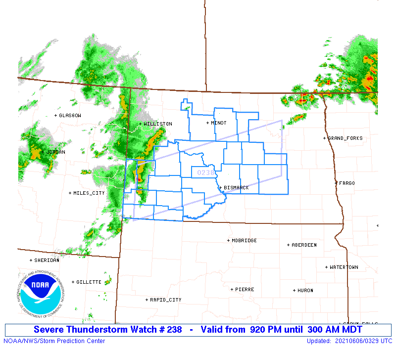
Severe Thunderstorm Watch Number 238
NWS Storm Prediction Center Norman OK
920 PM MDT Sat Jun 5 2021
The NWS Storm Prediction Center has issued a
* Severe Thunderstorm Watch for portions of
Southwest into central North Dakota
* Effective this Saturday night and Sunday morning from 920 PM
until 300 AM MDT.
* Primary threats include...
Scattered damaging wind gusts to 70 mph possible
Isolated large hail events to 1.5 inches in diameter possible
SUMMARY...A broken band of high-based thunderstorms may intensify
some in the next few hours while spreading east-northeastward from
southwest into central North Dakota. Damaging winds will be the
main threat, though isolated large hail may occur with the strongest
storms.
The severe thunderstorm watch area is approximately along and 45
statute miles north and south of a line from 45 miles west southwest
of Dickinson ND to 30 miles south southeast of Devils Lake ND. For a
complete depiction of the watch see the associated watch outline
update (WOUS64 KWNS WOU8).
PRECAUTIONARY/PREPAREDNESS ACTIONS...
REMEMBER...A Severe Thunderstorm Watch means conditions are
favorable for severe thunderstorms in and close to the watch area.
Persons in these areas should be on the lookout for threatening
weather conditions and listen for later statements and possible
warnings. Severe thunderstorms can and occasionally do produce
tornadoes.
&&
AVIATION...A few severe thunderstorms with hail surface and aloft to
1.5 inches. Extreme turbulence and surface wind gusts to 60 knots. A
few cumulonimbi with maximum tops to 500. Mean storm motion vector
25035.
...Thompson

   SEL8

   URGENT - IMMEDIATE BROADCAST REQUESTED
   Severe Thunderstorm Watch Number 238
   NWS Storm Prediction Center Norman OK
   920 PM MDT Sat Jun 5 2021

   The NWS Storm Prediction Center has issued a

   * Severe Thunderstorm Watch for portions of
     Southwest into central North Dakota

   * Effective this Saturday night and Sunday morning from 920 PM
     until 300 AM MDT.

   * Primary threats include...
     Scattered damaging wind gusts to 70 mph possible
     Isolated large hail events to 1.5 inches in diameter possible

   SUMMARY...A broken band of high-based thunderstorms may intensify
   some in the next few hours while spreading east-northeastward from
   southwest into central North Dakota.  Damaging winds will be the
   main threat, though isolated large hail may occur with the strongest
   storms.

   The severe thunderstorm watch area is approximately along and 45
   statute miles north and south of a line from 45 miles west southwest
   of Dickinson ND to 30 miles south southeast of Devils Lake ND. For a
   complete depiction of the watch see the associated watch outline
   update (WOUS64 KWNS WOU8).

   PRECAUTIONARY/PREPAREDNESS ACTIONS...

   REMEMBER...A Severe Thunderstorm Watch means conditions are
   favorable for severe thunderstorms in and close to the watch area.
   Persons in these areas should be on the lookout for threatening
   weather conditions and listen for later statements and possible
   warnings. Severe thunderstorms can and occasionally do produce
   tornadoes.

   &&

   AVIATION...A few severe thunderstorms with hail surface and aloft to
   1.5 inches. Extreme turbulence and surface wind gusts to 60 knots. A
   few cumulonimbi with maximum tops to 500. Mean storm motion vector
   25035.

   ...Thompson
 Note:
The Aviation Watch (SAW) product is an approximation to the watch area.
The actual watch is depicted by the shaded areas.
Note:
The Aviation Watch (SAW) product is an approximation to the watch area.
The actual watch is depicted by the shaded areas.
   SAW8
   WW 238 SEVERE TSTM ND 060320Z - 060900Z
   AXIS..45 STATUTE MILES NORTH AND SOUTH OF LINE..
   45WSW DIK/DICKINSON ND/ - 30SSE DVL/DEVILS LAKE ND/
   ..AVIATION COORDS.. 40NM N/S /42WSW DIK - 61WSW GFK/
   HAIL SURFACE AND ALOFT..1.5 INCHES. WIND GUSTS..60 KNOTS.
   MAX TOPS TO 500. MEAN STORM MOTION VECTOR 25035.

   LAT...LON 47200367 48379867 47079867 45900367

   THIS IS AN APPROXIMATION TO THE WATCH AREA.  FOR A
   COMPLETE DEPICTION OF THE WATCH SEE WOUS64 KWNS
   FOR WOU8.
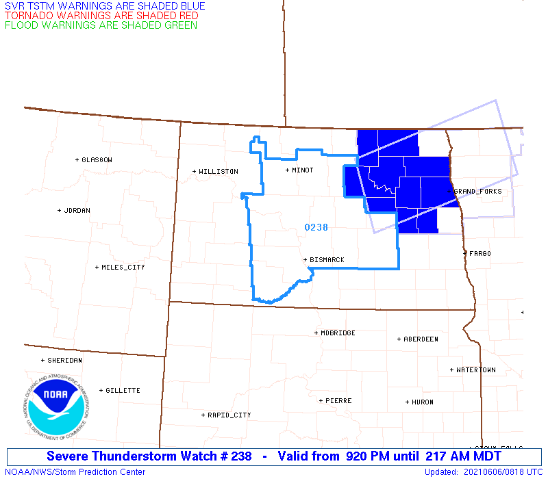
Watch 238 Status Report Messages:
STATUS REPORT #3 ON WW 238

VALID 060725Z - 060840Z

SEVERE WEATHER THREAT CONTINUES RIGHT OF A LINE FROM 15 SE BIS TO
35 ESE DIK TO 15 NE N60.

..KERR..06/06/21

ATTN...WFO...BIS...

&&

STATUS REPORT FOR WS 238

SEVERE WEATHER THREAT CONTINUES FOR THE FOLLOWING AREAS

NDC015-031-043-049-055-057-059-065-069-083-093-103-060840-

ND
.    NORTH DAKOTA COUNTIES INCLUDED ARE

BURLEIGH	     FOSTER		 KIDDER
MCHENRY 	     MCLEAN		 MERCER
MORTON		     OLIVER		 PIERCE
SHERIDAN	     STUTSMAN		 WELLS
$$


THE WATCH STATUS MESSAGE IS FOR GUIDANCE PURPOSES ONLY.  PLEASE
REFER TO WATCH COUNTY NOTIFICATION STATEMENTS FOR OFFICIAL
INFORMATION ON COUNTIES...INDEPENDENT CITIES AND MARINE ZONES
CLEARED FROM SEVERE THUNDERSTORM AND TORNADO WATCHES.
$$

STATUS REPORT #2 ON WW 238

VALID 060630Z - 060740Z

SEVERE WEATHER THREAT CONTINUES RIGHT OF A LINE FROM 40 W Y22 TO
30 W N60.

..KERR..06/06/21

ATTN...WFO...BIS...

&&

STATUS REPORT FOR WS 238

SEVERE WEATHER THREAT CONTINUES FOR THE FOLLOWING AREAS

NDC001-015-025-031-037-041-043-049-055-057-059-065-069-083-089-
093-101-103-060740-

ND
.    NORTH DAKOTA COUNTIES INCLUDED ARE

ADAMS		     BURLEIGH		 DUNN
FOSTER		     GRANT		 HETTINGER
KIDDER		     MCHENRY		 MCLEAN
MERCER		     MORTON		 OLIVER
PIERCE		     SHERIDAN		 STARK
STUTSMAN	     WARD		 WELLS
$$


THE WATCH STATUS MESSAGE IS FOR GUIDANCE PURPOSES ONLY.  PLEASE
REFER TO WATCH COUNTY NOTIFICATION STATEMENTS FOR OFFICIAL
INFORMATION ON COUNTIES...INDEPENDENT CITIES AND MARINE ZONES
CLEARED FROM SEVERE THUNDERSTORM AND TORNADO WATCHES.
$$

STATUS REPORT #1 ON WW 238

VALID 060545Z - 060640Z

SEVERE WEATHER THREAT CONTINUES RIGHT OF A LINE FROM 35 ENE BHK
TO 15 NW DIK TO 50 NNE DIK.

..KERR..06/06/21

ATTN...WFO...BIS...

&&

STATUS REPORT FOR WS 238

SEVERE WEATHER THREAT CONTINUES FOR THE FOLLOWING AREAS

NDC001-011-015-025-031-037-041-043-049-055-057-059-065-069-083-
087-089-093-101-103-060640-

ND
.    NORTH DAKOTA COUNTIES INCLUDED ARE

ADAMS		     BOWMAN		 BURLEIGH
DUNN		     FOSTER		 GRANT
HETTINGER	     KIDDER		 MCHENRY
MCLEAN		     MERCER		 MORTON
OLIVER		     PIERCE		 SHERIDAN
SLOPE		     STARK		 STUTSMAN
WARD		     WELLS
$$


THE WATCH STATUS MESSAGE IS FOR GUIDANCE PURPOSES ONLY.  PLEASE
REFER TO WATCH COUNTY NOTIFICATION STATEMENTS FOR OFFICIAL
INFORMATION ON COUNTIES...INDEPENDENT CITIES AND MARINE ZONES
CLEARED FROM SEVERE THUNDERSTORM AND TORNADO WATCHES.
$$
Note:
Click for Complete Product Text.
Tornadoes
Probability of 2 or more tornadoes
|
Low (<5%)
|
Probability of 1 or more strong (EF2-EF5) tornadoes
|
Low (<2%)
|
Wind
Probability of 10 or more severe wind events
|
Mod (40%)
|
Probability of 1 or more wind events > 65 knots
|
Low (20%)
|
Hail
Probability of 10 or more severe hail events
|
Low (20%)
|
Probability of 1 or more hailstones > 2 inches
|
Low (10%)
|
Combined Severe Hail/Wind
Probability of 6 or more combined severe hail/wind events
|
Mod (60%)
|
For each watch, probabilities for particular events inside the watch
(listed above in each table) are determined by the issuing forecaster.
The "Low" category contains probability values ranging from less than 2%
to 20% (EF2-EF5 tornadoes), less than 5% to 20% (all other probabilities),
"Moderate" from 30% to 60%, and "High" from 70% to greater than 95%.
High values are bolded and lighter in color to provide awareness of
an increased threat for a particular event.


 @NWSSPC