Note:
The expiration time in the watch graphic is amended if the watch is
replaced, cancelled or extended.
Note:
Note:
The expiration time in the watch graphic is amended if the watch is
replaced, cancelled or extended.
Note: Click for
Watch Status Reports.
SEL3
URGENT - IMMEDIATE BROADCAST REQUESTED
Tornado Watch Number 223
NWS Storm Prediction Center Norman OK
145 PM MDT Sat May 29 2021
The NWS Storm Prediction Center has issued a
* Tornado Watch for portions of
Southeast Colorado
* Effective this Saturday afternoon and evening from 145 PM until
900 PM MDT.
* Primary threats include...
A couple tornadoes possible
Scattered large hail and isolated very large hail events to 2.5
inches in diameter likely
Scattered damaging wind gusts to 70 mph possible
SUMMARY...Thunderstorms are developing over the foothills of eastern
Colorado. These storms will track eastward into a progressively
more moist/unstable airmass, with the potential for very large hail
and damaging winds in the stronger cells. A few tornadoes are also
possible this afternoon and evening.
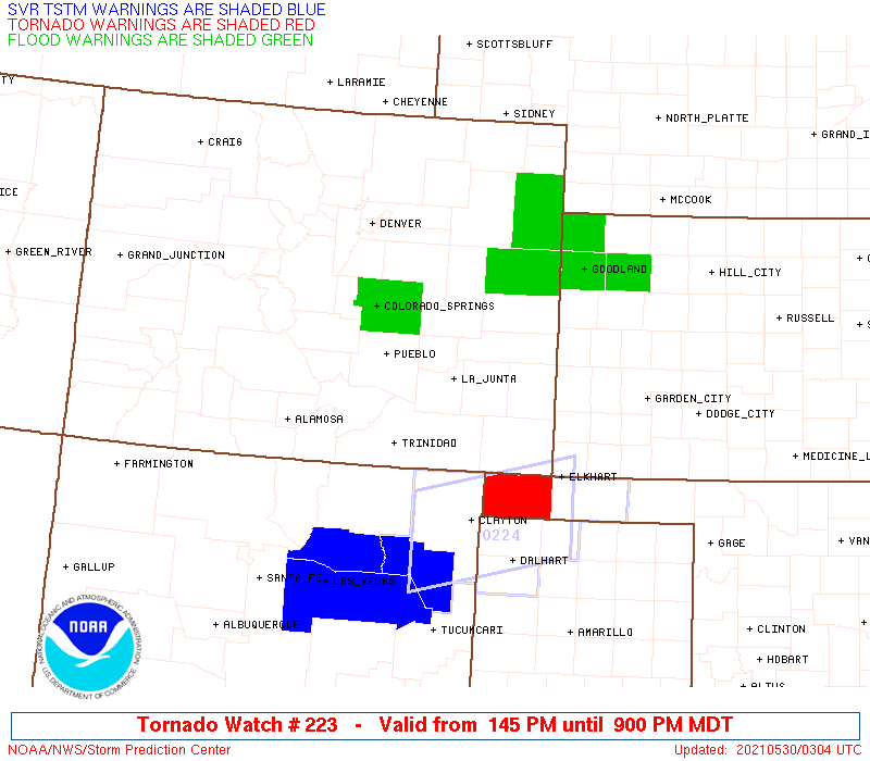
The tornado watch area is approximately along and 65 statute miles
north and south of a line from 20 miles west of Pueblo CO to 35
miles east southeast of Lamar CO. For a complete depiction of the
watch see the associated watch outline update (WOUS64 KWNS WOU3).
PRECAUTIONARY/PREPAREDNESS ACTIONS...
REMEMBER...A Tornado Watch means conditions are favorable for
tornadoes and severe thunderstorms in and close to the watch
area. Persons in these areas should be on the lookout for
threatening weather conditions and listen for later statements
and possible warnings.
&&
AVIATION...Tornadoes and a few severe thunderstorms with hail
surface and aloft to 2.5 inches. Extreme turbulence and surface wind
gusts to 60 knots. A few cumulonimbi with maximum tops to 450. Mean
storm motion vector 27030.
...Hart

   SEL3

   URGENT - IMMEDIATE BROADCAST REQUESTED
   Tornado Watch Number 223
   NWS Storm Prediction Center Norman OK
   145 PM MDT Sat May 29 2021

   The NWS Storm Prediction Center has issued a

   * Tornado Watch for portions of
     Southeast Colorado

   * Effective this Saturday afternoon and evening from 145 PM until
     900 PM MDT.

   * Primary threats include...
     A couple tornadoes possible
     Scattered large hail and isolated very large hail events to 2.5
       inches in diameter likely
     Scattered damaging wind gusts to 70 mph possible

   SUMMARY...Thunderstorms are developing over the foothills of eastern
   Colorado.  These storms will track eastward into a progressively
   more moist/unstable airmass, with the potential for very large hail
   and damaging winds in the stronger cells.  A few tornadoes are also
   possible this afternoon and evening.

   The tornado watch area is approximately along and 65 statute miles
   north and south of a line from 20 miles west of Pueblo CO to 35
   miles east southeast of Lamar CO. For a complete depiction of the
   watch see the associated watch outline update (WOUS64 KWNS WOU3).

   PRECAUTIONARY/PREPAREDNESS ACTIONS...

   REMEMBER...A Tornado Watch means conditions are favorable for
   tornadoes and severe thunderstorms in and close to the watch
   area. Persons in these areas should be on the lookout for
   threatening weather conditions and listen for later statements
   and possible warnings.

   &&

   AVIATION...Tornadoes and a few severe thunderstorms with hail
   surface and aloft to 2.5 inches. Extreme turbulence and surface wind
   gusts to 60 knots. A few cumulonimbi with maximum tops to 450. Mean
   storm motion vector 27030.

   ...Hart
 Note:
The Aviation Watch (SAW) product is an approximation to the watch area.
The actual watch is depicted by the shaded areas.
Note:
The Aviation Watch (SAW) product is an approximation to the watch area.
The actual watch is depicted by the shaded areas.
   SAW3
   WW 223 TORNADO CO 291945Z - 300300Z
   AXIS..65 STATUTE MILES NORTH AND SOUTH OF LINE..
   20W PUB/PUEBLO CO/ - 35ESE LAA/LAMAR CO/
   ..AVIATION COORDS.. 55NM N/S /21W PUB - 35SE LAA/
   HAIL SURFACE AND ALOFT..2.5 INCHES. WIND GUSTS..60 KNOTS.
   MAX TOPS TO 450. MEAN STORM MOTION VECTOR 27030.

   LAT...LON 39220487 38820209 36930209 37340487

   THIS IS AN APPROXIMATION TO THE WATCH AREA.  FOR A
   COMPLETE DEPICTION OF THE WATCH SEE WOUS64 KWNS
   FOR WOU3.
Watch 223 Status Report Messages:
STATUS REPORT #6 ON WW 223

VALID 300230Z - 300300Z

SEVERE WEATHER THREAT CONTINUES RIGHT OF A LINE FROM 40 NNW CAO
TO 25 WNW SPD TO 35 N EHA.

WW 223 WILL BE ALLOWED TO EXPIRE AT 300300Z.

..DEAN..05/30/21

ATTN...WFO...PUB...GLD...BOU...

&&

STATUS REPORT FOR WT 223

SEVERE WEATHER THREAT CONTINUES FOR THE FOLLOWING AREAS

COC009-071-300300-

CO
.    COLORADO COUNTIES INCLUDED ARE

BACA		     LAS ANIMAS
$$


THE WATCH STATUS MESSAGE IS FOR GUIDANCE PURPOSES ONLY.  PLEASE
REFER TO WATCH COUNTY NOTIFICATION STATEMENTS FOR OFFICIAL
INFORMATION ON COUNTIES...INDEPENDENT CITIES AND MARINE ZONES
CLEARED FROM SEVERE THUNDERSTORM AND TORNADO WATCHES.
$$

STATUS REPORT #5 ON WW 223

VALID 300130Z - 300240Z

SEVERE WEATHER THREAT CONTINUES RIGHT OF A LINE FROM 30 SE TAD TO
40 NNE LHX TO 35 W ITR.

..DEAN..05/30/21

ATTN...WFO...PUB...GLD...BOU...

&&

STATUS REPORT FOR WT 223

SEVERE WEATHER THREAT CONTINUES FOR THE FOLLOWING AREAS

COC009-011-017-061-071-099-300240-

CO
.    COLORADO COUNTIES INCLUDED ARE

BACA		     BENT		 CHEYENNE
KIOWA		     LAS ANIMAS 	 PROWERS
$$


THE WATCH STATUS MESSAGE IS FOR GUIDANCE PURPOSES ONLY.  PLEASE
REFER TO WATCH COUNTY NOTIFICATION STATEMENTS FOR OFFICIAL
INFORMATION ON COUNTIES...INDEPENDENT CITIES AND MARINE ZONES
CLEARED FROM SEVERE THUNDERSTORM AND TORNADO WATCHES.
$$

STATUS REPORT #4 ON WW 223

VALID 292335Z - 300040Z

THE SEVERE WEATHER THREAT CONTINUES ACROSS THE ENTIRE WATCH AREA.

FOR ADDITIONAL INFORMATION SEE MESOSCALE DISCUSSION 803 AND 0804.

..DEAN..05/29/21

ATTN...WFO...PUB...GLD...BOU...

&&

STATUS REPORT FOR WT 223

SEVERE WEATHER THREAT CONTINUES FOR THE FOLLOWING AREAS

COC009-011-017-025-039-041-061-071-073-089-099-101-300040-

CO
.    COLORADO COUNTIES INCLUDED ARE

BACA		     BENT		 CHEYENNE
CROWLEY 	     ELBERT		 EL PASO
KIOWA		     LAS ANIMAS 	 LINCOLN
OTERO		     PROWERS		 PUEBLO
$$


THE WATCH STATUS MESSAGE IS FOR GUIDANCE PURPOSES ONLY.  PLEASE
REFER TO WATCH COUNTY NOTIFICATION STATEMENTS FOR OFFICIAL
INFORMATION ON COUNTIES...INDEPENDENT CITIES AND MARINE ZONES
CLEARED FROM SEVERE THUNDERSTORM AND TORNADO WATCHES.
$$

STATUS REPORT #3 ON WW 223

VALID 292235Z - 292340Z

THE SEVERE WEATHER THREAT CONTINUES ACROSS THE ENTIRE WATCH AREA.

..DEAN..05/29/21

ATTN...WFO...PUB...GLD...BOU...

&&

STATUS REPORT FOR WT 223

SEVERE WEATHER THREAT CONTINUES FOR THE FOLLOWING AREAS

COC009-011-017-025-039-041-061-071-073-089-099-101-292340-

CO
.    COLORADO COUNTIES INCLUDED ARE

BACA		     BENT		 CHEYENNE
CROWLEY 	     ELBERT		 EL PASO
KIOWA		     LAS ANIMAS 	 LINCOLN
OTERO		     PROWERS		 PUEBLO
$$


THE WATCH STATUS MESSAGE IS FOR GUIDANCE PURPOSES ONLY.  PLEASE
REFER TO WATCH COUNTY NOTIFICATION STATEMENTS FOR OFFICIAL
INFORMATION ON COUNTIES...INDEPENDENT CITIES AND MARINE ZONES
CLEARED FROM SEVERE THUNDERSTORM AND TORNADO WATCHES.
$$

STATUS REPORT #2 ON WW 223

VALID 292130Z - 292240Z

THE SEVERE WEATHER THREAT CONTINUES ACROSS THE ENTIRE WATCH AREA.

..DEAN..05/29/21

ATTN...WFO...PUB...GLD...BOU...

&&

STATUS REPORT FOR WT 223

SEVERE WEATHER THREAT CONTINUES FOR THE FOLLOWING AREAS

COC009-011-017-025-039-041-061-071-073-089-099-101-292240-

CO
.    COLORADO COUNTIES INCLUDED ARE

BACA		     BENT		 CHEYENNE
CROWLEY 	     ELBERT		 EL PASO
KIOWA		     LAS ANIMAS 	 LINCOLN
OTERO		     PROWERS		 PUEBLO
$$


THE WATCH STATUS MESSAGE IS FOR GUIDANCE PURPOSES ONLY.  PLEASE
REFER TO WATCH COUNTY NOTIFICATION STATEMENTS FOR OFFICIAL
INFORMATION ON COUNTIES...INDEPENDENT CITIES AND MARINE ZONES
CLEARED FROM SEVERE THUNDERSTORM AND TORNADO WATCHES.
$$

STATUS REPORT #1 ON WW 223

VALID 292025Z - 292140Z

THE SEVERE WEATHER THREAT CONTINUES ACROSS THE ENTIRE WATCH AREA.

..BUNTING..05/29/21

ATTN...WFO...PUB...GLD...BOU...

&&

STATUS REPORT FOR WT 223

SEVERE WEATHER THREAT CONTINUES FOR THE FOLLOWING AREAS

COC009-011-017-025-039-041-061-071-073-089-099-101-292140-

CO
.    COLORADO COUNTIES INCLUDED ARE

BACA		     BENT		 CHEYENNE
CROWLEY 	     ELBERT		 EL PASO
KIOWA		     LAS ANIMAS 	 LINCOLN
OTERO		     PROWERS		 PUEBLO
$$


THE WATCH STATUS MESSAGE IS FOR GUIDANCE PURPOSES ONLY.  PLEASE
REFER TO WATCH COUNTY NOTIFICATION STATEMENTS FOR OFFICIAL
INFORMATION ON COUNTIES...INDEPENDENT CITIES AND MARINE ZONES
CLEARED FROM SEVERE THUNDERSTORM AND TORNADO WATCHES.
$$
Note:
Click for Complete Product Text.
Tornadoes
Probability of 2 or more tornadoes
|
Mod (40%)
|
Probability of 1 or more strong (EF2-EF5) tornadoes
|
Low (20%)
|
Wind
Probability of 10 or more severe wind events
|
Mod (40%)
|
Probability of 1 or more wind events > 65 knots
|
Low (20%)
|
Hail
Probability of 10 or more severe hail events
|
High (70%)
|
Probability of 1 or more hailstones > 2 inches
|
Mod (60%)
|
Combined Severe Hail/Wind
Probability of 6 or more combined severe hail/wind events
|
High (90%)
|
For each watch, probabilities for particular events inside the watch
(listed above in each table) are determined by the issuing forecaster.
The "Low" category contains probability values ranging from less than 2%
to 20% (EF2-EF5 tornadoes), less than 5% to 20% (all other probabilities),
"Moderate" from 30% to 60%, and "High" from 70% to greater than 95%.
High values are bolded and lighter in color to provide awareness of
an increased threat for a particular event.


 @NWSSPC