Note:
The expiration time in the watch graphic is amended if the watch is
replaced, cancelled or extended.
Note:
Note:
The expiration time in the watch graphic is amended if the watch is
replaced, cancelled or extended.
Note: Click for
Watch Status Reports.
SEL8
URGENT - IMMEDIATE BROADCAST REQUESTED
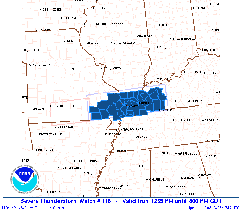
Severe Thunderstorm Watch Number 118
NWS Storm Prediction Center Norman OK
1235 PM CDT Wed Apr 28 2021
The NWS Storm Prediction Center has issued a
* Severe Thunderstorm Watch for portions of
Southern Illinois
Western Kentucky
Southeast Missouri
* Effective this Wednesday afternoon and evening from 1235 PM
until 800 PM CDT.
* Primary threats include...
Scattered damaging wind gusts to 70 mph possible
Scattered large hail events to 1.5 inches in diameter possible
A tornado or two possible
SUMMARY...A long-lived cluster of thunderstorms over south-central
Missouri will track eastward across the watch area, while new storms
intensify ahead of it. Damaging winds and hail are the primary
threats, although a tornado or two cannot be ruled out.
The severe thunderstorm watch area is approximately along and 40
statute miles north and south of a line from 50 miles west northwest
of Poplar Bluff MO to 40 miles south southeast of Owensboro KY. For
a complete depiction of the watch see the associated watch outline
update (WOUS64 KWNS WOU8).
PRECAUTIONARY/PREPAREDNESS ACTIONS...
REMEMBER...A Severe Thunderstorm Watch means conditions are
favorable for severe thunderstorms in and close to the watch area.
Persons in these areas should be on the lookout for threatening
weather conditions and listen for later statements and possible
warnings. Severe thunderstorms can and occasionally do produce
tornadoes.
&&
OTHER WATCH INFORMATION...CONTINUE...WW 117...
AVIATION...A few severe thunderstorms with hail surface and aloft to
1.5 inches. Extreme turbulence and surface wind gusts to 60 knots. A
few cumulonimbi with maximum tops to 500. Mean storm motion vector
26030.
...Hart

   SEL8

   URGENT - IMMEDIATE BROADCAST REQUESTED
   Severe Thunderstorm Watch Number 118
   NWS Storm Prediction Center Norman OK
   1235 PM CDT Wed Apr 28 2021

   The NWS Storm Prediction Center has issued a

   * Severe Thunderstorm Watch for portions of
     Southern Illinois
     Western Kentucky
     Southeast Missouri

   * Effective this Wednesday afternoon and evening from 1235 PM
     until 800 PM CDT.

   * Primary threats include...
     Scattered damaging wind gusts to 70 mph possible
     Scattered large hail events to 1.5 inches in diameter possible
     A tornado or two possible

   SUMMARY...A long-lived cluster of thunderstorms over south-central
   Missouri will track eastward across the watch area, while new storms
   intensify ahead of it.  Damaging winds and hail are the primary
   threats, although a tornado or two cannot be ruled out.

   The severe thunderstorm watch area is approximately along and 40
   statute miles north and south of a line from 50 miles west northwest
   of Poplar Bluff MO to 40 miles south southeast of Owensboro KY. For
   a complete depiction of the watch see the associated watch outline
   update (WOUS64 KWNS WOU8).

   PRECAUTIONARY/PREPAREDNESS ACTIONS...

   REMEMBER...A Severe Thunderstorm Watch means conditions are
   favorable for severe thunderstorms in and close to the watch area.
   Persons in these areas should be on the lookout for threatening
   weather conditions and listen for later statements and possible
   warnings. Severe thunderstorms can and occasionally do produce
   tornadoes.

   &&

   OTHER WATCH INFORMATION...CONTINUE...WW 117...

   AVIATION...A few severe thunderstorms with hail surface and aloft to
   1.5 inches. Extreme turbulence and surface wind gusts to 60 knots. A
   few cumulonimbi with maximum tops to 500. Mean storm motion vector
   26030.

   ...Hart
 Note:
The Aviation Watch (SAW) product is an approximation to the watch area.
The actual watch is depicted by the shaded areas.
Note:
The Aviation Watch (SAW) product is an approximation to the watch area.
The actual watch is depicted by the shaded areas.
   SAW8
   WW 118 SEVERE TSTM IL KY MO 281735Z - 290100Z
   AXIS..40 STATUTE MILES NORTH AND SOUTH OF LINE..
   50WNW POF/POPLAR BLUFF MO/ - 40SSE OWB/OWENSBORO KY/
   ..AVIATION COORDS.. 35NM N/S /59NNW ARG - 27NW BWG/
   HAIL SURFACE AND ALOFT..1.5 INCHES. WIND GUSTS..60 KNOTS.
   MAX TOPS TO 500. MEAN STORM MOTION VECTOR 26030.

   LAT...LON 37629131 37758689 36618689 36479131

   THIS IS AN APPROXIMATION TO THE WATCH AREA.  FOR A
   COMPLETE DEPICTION OF THE WATCH SEE WOUS64 KWNS
   FOR WOU8.
Watch 118 Status Report Messages:
STATUS REPORT #6 ON WW 118

VALID 290030Z - 290100Z

SEVERE WEATHER THREAT CONTINUES RIGHT OF A LINE FROM 45 SSE PAH
TO 30 NW HOP TO 35 NNW HOP TO 30 WSW OWB.

WW 118 WILL BE ALLOWED TO EXPIRE AT 290100Z.

FOR ADDITIONAL INFORMATION SEE MESOSCALE DISCUSSION 460

..MOORE..04/29/21

ATTN...WFO...PAH...

&&

STATUS REPORT FOR WS 118

SEVERE WEATHER THREAT CONTINUES FOR THE FOLLOWING AREAS

KYC047-107-177-219-221-290100-

KY
.    KENTUCKY COUNTIES INCLUDED ARE

CHRISTIAN	     HOPKINS		 MUHLENBERG
TODD		     TRIGG
$$


THE WATCH STATUS MESSAGE IS FOR GUIDANCE PURPOSES ONLY.  PLEASE
REFER TO WATCH COUNTY NOTIFICATION STATEMENTS FOR OFFICIAL
INFORMATION ON COUNTIES...INDEPENDENT CITIES AND MARINE ZONES
CLEARED FROM SEVERE THUNDERSTORM AND TORNADO WATCHES.
$$

STATUS REPORT #5 ON WW 118

VALID 282330Z - 290040Z

SEVERE WEATHER THREAT CONTINUES RIGHT OF A LINE FROM 50 ENE DYR
TO 35 ESE MVN.

FOR ADDITIONAL INFORMATION SEE MESOSCALE DISCUSSION 456

..MOORE..04/28/21

ATTN...WFO...PAH...

&&

STATUS REPORT FOR WS 118

SEVERE WEATHER THREAT CONTINUES FOR THE FOLLOWING AREAS

KYC033-035-047-055-107-139-143-157-177-219-221-290040-

KY
.    KENTUCKY COUNTIES INCLUDED ARE

CALDWELL	     CALLOWAY		 CHRISTIAN
CRITTENDEN	     HOPKINS		 LIVINGSTON
LYON		     MARSHALL		 MUHLENBERG
TODD		     TRIGG
$$


THE WATCH STATUS MESSAGE IS FOR GUIDANCE PURPOSES ONLY.  PLEASE
REFER TO WATCH COUNTY NOTIFICATION STATEMENTS FOR OFFICIAL
INFORMATION ON COUNTIES...INDEPENDENT CITIES AND MARINE ZONES
CLEARED FROM SEVERE THUNDERSTORM AND TORNADO WATCHES.
$$

STATUS REPORT #4 ON WW 118

VALID 282230Z - 282340Z

SEVERE WEATHER THREAT CONTINUES RIGHT OF A LINE FROM 30 NNE DYR
TO 25 SE MVN.

FOR ADDITIONAL INFORMATION SEE MESOSCALE DISCUSSION 456

..MOORE..04/28/21

ATTN...WFO...PAH...

&&

STATUS REPORT FOR WS 118

SEVERE WEATHER THREAT CONTINUES FOR THE FOLLOWING AREAS

ILC069-127-151-282340-

IL
.    ILLINOIS COUNTIES INCLUDED ARE

HARDIN		     MASSAC		 POPE
$$


KYC007-033-035-039-047-055-075-083-105-107-139-143-145-149-157-
177-219-221-233-282340-

KY
.    KENTUCKY COUNTIES INCLUDED ARE

BALLARD 	     CALDWELL		 CALLOWAY
CARLISLE	     CHRISTIAN		 CRITTENDEN
FULTON		     GRAVES		 HICKMAN
HOPKINS 	     LIVINGSTON 	 LYON
MCCRACKEN	     MCLEAN		 MARSHALL
MUHLENBERG	     TODD		 TRIGG
WEBSTER
$$


THE WATCH STATUS MESSAGE IS FOR GUIDANCE PURPOSES ONLY.  PLEASE
REFER TO WATCH COUNTY NOTIFICATION STATEMENTS FOR OFFICIAL
INFORMATION ON COUNTIES...INDEPENDENT CITIES AND MARINE ZONES
CLEARED FROM SEVERE THUNDERSTORM AND TORNADO WATCHES.
$$

STATUS REPORT #3 ON WW 118

VALID 282140Z - 282240Z

SEVERE WEATHER THREAT CONTINUES RIGHT OF A LINE FROM 30 NW DYR TO
15 NNE MDH.

FOR ADDITIONAL INFORMATION SEE MESOSCALE DISCUSSION 454

..MOORE..04/28/21

ATTN...WFO...PAH...

&&

STATUS REPORT FOR WS 118

SEVERE WEATHER THREAT CONTINUES FOR THE FOLLOWING AREAS

ILC003-069-087-127-151-153-181-282240-

IL
.    ILLINOIS COUNTIES INCLUDED ARE

ALEXANDER	     HARDIN		 JOHNSON
MASSAC		     POPE		 PULASKI
UNION
$$


KYC007-033-035-039-047-055-075-083-105-107-139-143-145-149-157-
177-219-221-233-282240-

KY
.    KENTUCKY COUNTIES INCLUDED ARE

BALLARD 	     CALDWELL		 CALLOWAY
CARLISLE	     CHRISTIAN		 CRITTENDEN
FULTON		     GRAVES		 HICKMAN
HOPKINS 	     LIVINGSTON 	 LYON
MCCRACKEN	     MCLEAN		 MARSHALL
MUHLENBERG	     TODD		 TRIGG
WEBSTER
$$


MOC133-143-201-282240-

MO
.    MISSOURI COUNTIES INCLUDED ARE

MISSISSIPPI	     NEW MADRID 	 SCOTT
$$


THE WATCH STATUS MESSAGE IS FOR GUIDANCE PURPOSES ONLY.  PLEASE
REFER TO WATCH COUNTY NOTIFICATION STATEMENTS FOR OFFICIAL
INFORMATION ON COUNTIES...INDEPENDENT CITIES AND MARINE ZONES
CLEARED FROM SEVERE THUNDERSTORM AND TORNADO WATCHES.
$$

STATUS REPORT #2 ON WW 118

VALID 282050Z - 282140Z

SEVERE WEATHER THREAT CONTINUES RIGHT OF A LINE FROM 25 NE ARG TO
25 SW CGI TO 10 NW MDH.

FOR ADDITIONAL INFORMATION SEE MESOSCALE DISCUSSION 454

..SQUITIERI..04/28/21

ATTN...WFO...PAH...

&&

STATUS REPORT FOR WS 118

SEVERE WEATHER THREAT CONTINUES FOR THE FOLLOWING AREAS

ILC003-069-087-127-151-153-181-282140-

IL
.    ILLINOIS COUNTIES INCLUDED ARE

ALEXANDER	     HARDIN		 JOHNSON
MASSAC		     POPE		 PULASKI
UNION
$$


KYC007-033-035-039-047-055-075-083-105-107-139-143-145-149-157-
177-219-221-233-282140-

KY
.    KENTUCKY COUNTIES INCLUDED ARE

BALLARD 	     CALDWELL		 CALLOWAY
CARLISLE	     CHRISTIAN		 CRITTENDEN
FULTON		     GRAVES		 HICKMAN
HOPKINS 	     LIVINGSTON 	 LYON
MCCRACKEN	     MCLEAN		 MARSHALL
MUHLENBERG	     TODD		 TRIGG
WEBSTER
$$


MOC133-143-201-207-282140-

MO
.    MISSOURI COUNTIES INCLUDED ARE

MISSISSIPPI	     NEW MADRID 	 SCOTT
STODDARD
$$


THE WATCH STATUS MESSAGE IS FOR GUIDANCE PURPOSES ONLY.  PLEASE
REFER TO WATCH COUNTY NOTIFICATION STATEMENTS FOR OFFICIAL
INFORMATION ON COUNTIES...INDEPENDENT CITIES AND MARINE ZONES
CLEARED FROM SEVERE THUNDERSTORM AND TORNADO WATCHES.
$$

STATUS REPORT #1 ON WW 118

VALID 281855Z - 281940Z

SEVERE WEATHER THREAT CONTINUES RIGHT OF A LINE FROM 25 ENE UNO
TO 20 NW POF TO 5 NW FAM.

..SQUITIERI..04/28/21

ATTN...WFO...PAH...

&&

STATUS REPORT FOR WS 118

SEVERE WEATHER THREAT CONTINUES FOR THE FOLLOWING AREAS

ILC003-069-087-127-151-153-181-281940-

IL
.    ILLINOIS COUNTIES INCLUDED ARE

ALEXANDER	     HARDIN		 JOHNSON
MASSAC		     POPE		 PULASKI
UNION
$$


KYC007-033-035-039-047-055-075-083-105-107-139-143-145-149-157-
177-219-221-233-281940-

KY
.    KENTUCKY COUNTIES INCLUDED ARE

BALLARD 	     CALDWELL		 CALLOWAY
CARLISLE	     CHRISTIAN		 CRITTENDEN
FULTON		     GRAVES		 HICKMAN
HOPKINS 	     LIVINGSTON 	 LYON
MCCRACKEN	     MCLEAN		 MARSHALL
MUHLENBERG	     TODD		 TRIGG
WEBSTER
$$


MOC017-023-031-133-143-181-201-207-223-281940-

MO
.    MISSOURI COUNTIES INCLUDED ARE

BOLLINGER	     BUTLER		 CAPE GIRARDEAU
MISSISSIPPI	     NEW MADRID 	 RIPLEY
SCOTT		     STODDARD		 WAYNE
$$


THE WATCH STATUS MESSAGE IS FOR GUIDANCE PURPOSES ONLY.  PLEASE
REFER TO WATCH COUNTY NOTIFICATION STATEMENTS FOR OFFICIAL
INFORMATION ON COUNTIES...INDEPENDENT CITIES AND MARINE ZONES
CLEARED FROM SEVERE THUNDERSTORM AND TORNADO WATCHES.
$$
Note:
Click for Complete Product Text.
Tornadoes
Probability of 2 or more tornadoes
|
Low (20%)
|
Probability of 1 or more strong (EF2-EF5) tornadoes
|
Low (5%)
|
Wind
Probability of 10 or more severe wind events
|
Mod (50%)
|
Probability of 1 or more wind events > 65 knots
|
Low (20%)
|
Hail
Probability of 10 or more severe hail events
|
Mod (50%)
|
Probability of 1 or more hailstones > 2 inches
|
Low (20%)
|
Combined Severe Hail/Wind
Probability of 6 or more combined severe hail/wind events
|
High (80%)
|
For each watch, probabilities for particular events inside the watch
(listed above in each table) are determined by the issuing forecaster.
The "Low" category contains probability values ranging from less than 2%
to 20% (EF2-EF5 tornadoes), less than 5% to 20% (all other probabilities),
"Moderate" from 30% to 60%, and "High" from 70% to greater than 95%.
High values are bolded and lighter in color to provide awareness of
an increased threat for a particular event.


 @NWSSPC