 Note:
The expiration time in the watch graphic is amended if the watch is
replaced, cancelled or extended.
Note:
Note:
The expiration time in the watch graphic is amended if the watch is
replaced, cancelled or extended.
Note: Click for
Watch Status Reports.
SEL0
URGENT - IMMEDIATE BROADCAST REQUESTED
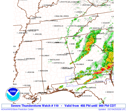
Severe Thunderstorm Watch Number 110
NWS Storm Prediction Center Norman OK
455 PM CDT Sat Apr 24 2021
The NWS Storm Prediction Center has issued a
* Severe Thunderstorm Watch for portions of
Parts of central and northeast Alabama
Parts of west central and northwest Georgia
* Effective this Saturday afternoon and evening from 455 PM until
900 PM CDT.
* Primary threats include...
Scattered large hail and isolated very large hail events to 2
inches in diameter possible
Scattered damaging wind gusts to 70 mph possible
SUMMARY...Scattered splitting supercells will persist through the
remainder of the afternoon into this evening, with an attendant
threat for large hail and isolated damaging gusts.
The severe thunderstorm watch area is approximately along and 65
statute miles north and south of a line from 20 miles west southwest
of Birmingham AL to 15 miles east southeast of Atlanta GA. For a
complete depiction of the watch see the associated watch outline
update (WOUS64 KWNS WOU0).
PRECAUTIONARY/PREPAREDNESS ACTIONS...
REMEMBER...A Severe Thunderstorm Watch means conditions are
favorable for severe thunderstorms in and close to the watch area.
Persons in these areas should be on the lookout for threatening
weather conditions and listen for later statements and possible
warnings. Severe thunderstorms can and occasionally do produce
tornadoes.
&&
OTHER WATCH INFORMATION...CONTINUE...WW 107...WW 108...WW 109...
AVIATION...A few severe thunderstorms with hail surface and aloft to
2 inches. Extreme turbulence and surface wind gusts to 60 knots. A
few cumulonimbi with maximum tops to 500. Mean storm motion vector
26040.
...Thompson

   SEL0

   URGENT - IMMEDIATE BROADCAST REQUESTED
   Severe Thunderstorm Watch Number 110
   NWS Storm Prediction Center Norman OK
   455 PM CDT Sat Apr 24 2021

   The NWS Storm Prediction Center has issued a

   * Severe Thunderstorm Watch for portions of
     Parts of central and northeast Alabama
     Parts of west central and northwest Georgia

   * Effective this Saturday afternoon and evening from 455 PM until
     900 PM CDT.

   * Primary threats include...
     Scattered large hail and isolated very large hail events to 2
       inches in diameter possible
     Scattered damaging wind gusts to 70 mph possible

   SUMMARY...Scattered splitting supercells will persist through the
   remainder of the afternoon into this evening, with an attendant
   threat for large hail and isolated damaging gusts.

   The severe thunderstorm watch area is approximately along and 65
   statute miles north and south of a line from 20 miles west southwest
   of Birmingham AL to 15 miles east southeast of Atlanta GA. For a
   complete depiction of the watch see the associated watch outline
   update (WOUS64 KWNS WOU0).

   PRECAUTIONARY/PREPAREDNESS ACTIONS...

   REMEMBER...A Severe Thunderstorm Watch means conditions are
   favorable for severe thunderstorms in and close to the watch area.
   Persons in these areas should be on the lookout for threatening
   weather conditions and listen for later statements and possible
   warnings. Severe thunderstorms can and occasionally do produce
   tornadoes.

   &&

   OTHER WATCH INFORMATION...CONTINUE...WW 107...WW 108...WW 109...

   AVIATION...A few severe thunderstorms with hail surface and aloft to
   2 inches. Extreme turbulence and surface wind gusts to 60 knots. A
   few cumulonimbi with maximum tops to 500. Mean storm motion vector
   26040.

   ...Thompson
 Note:
The Aviation Watch (SAW) product is an approximation to the watch area.
The actual watch is depicted by the shaded areas.
Note:
The Aviation Watch (SAW) product is an approximation to the watch area.
The actual watch is depicted by the shaded areas.
   SAW0
   WW 110 SEVERE TSTM AL GA 242155Z - 250200Z
   AXIS..65 STATUTE MILES NORTH AND SOUTH OF LINE..
   20WSW BHM/BIRMINGHAM AL/ - 15ESE ATL/ATLANTA GA/
   ..AVIATION COORDS.. 55NM N/S /15SW VUZ - 13ESE ATL/
   HAIL SURFACE AND ALOFT..2 INCHES. WIND GUSTS..60 KNOTS.
   MAX TOPS TO 500. MEAN STORM MOTION VECTOR 26040.

   LAT...LON 34408707 34498419 32618419 32528707

   THIS IS AN APPROXIMATION TO THE WATCH AREA.  FOR A
   COMPLETE DEPICTION OF THE WATCH SEE WOUS64 KWNS
   FOR WOU0.
Watch 110 Status Report Messages:
STATUS REPORT #4 ON WW 110

VALID 250125Z - 250240Z

SEVERE WEATHER THREAT CONTINUES RIGHT OF A LINE FROM 10 SW AUO TO
10 WSW LGC TO 20 NNE LGC TO 25 SSW ATL TO 15 NE ATL TO 40 NNW AHN.

FOR ADDITIONAL INFORMATION SEE MESOSCALE DISCUSSION 430

..MOORE..04/25/21

ATTN...WFO...BMX...HUN...FFC...

&&

STATUS REPORT FOR WS 110

SEVERE WEATHER THREAT CONTINUES FOR THE FOLLOWING AREAS

GAC013-035-063-113-135-151-171-199-217-231-247-255-285-293-297-
250240-

GA
.    GEORGIA COUNTIES INCLUDED ARE

BARROW		     BUTTS		 CLAYTON
FAYETTE 	     GWINNETT		 HENRY
LAMAR		     MERIWETHER 	 NEWTON
PIKE		     ROCKDALE		 SPALDING
TROUP		     UPSON		 WALTON
$$


THE WATCH STATUS MESSAGE IS FOR GUIDANCE PURPOSES ONLY.  PLEASE
REFER TO WATCH COUNTY NOTIFICATION STATEMENTS FOR OFFICIAL
INFORMATION ON COUNTIES...INDEPENDENT CITIES AND MARINE ZONES
CLEARED FROM SEVERE THUNDERSTORM AND TORNADO WATCHES.
$$

STATUS REPORT #3 ON WW 110

VALID 250030Z - 250140Z

SEVERE WEATHER THREAT CONTINUES RIGHT OF A LINE FROM 20 NNE MGM
TO 30 SSE ANB TO 40 W ATL TO 25 ESE RMG TO 40 ENE RMG.

FOR ADDITIONAL INFORMATION SEE MESOSCALE DISCUSSION 428

..MOORE..04/25/21

ATTN...WFO...BMX...HUN...FFC...

&&

STATUS REPORT FOR WS 110

SEVERE WEATHER THREAT CONTINUES FOR THE FOLLOWING AREAS

ALC017-111-123-250140-

AL
.    ALABAMA COUNTIES INCLUDED ARE

CHAMBERS	     RANDOLPH		 TALLAPOOSA
$$


GAC013-035-045-057-063-067-077-089-097-113-117-121-135-149-151-
171-199-217-223-231-247-255-285-293-297-250140-

GA
.    GEORGIA COUNTIES INCLUDED ARE

BARROW		     BUTTS		 CARROLL
CHEROKEE	     CLAYTON		 COBB
COWETA		     DEKALB		 DOUGLAS
FAYETTE 	     FORSYTH		 FULTON
GWINNETT	     HEARD		 HENRY
LAMAR		     MERIWETHER 	 NEWTON
PAULDING	     PIKE		 ROCKDALE
SPALDING	     TROUP		 UPSON
WALTON
$$


THE WATCH STATUS MESSAGE IS FOR GUIDANCE PURPOSES ONLY.  PLEASE
REFER TO WATCH COUNTY NOTIFICATION STATEMENTS FOR OFFICIAL
INFORMATION ON COUNTIES...INDEPENDENT CITIES AND MARINE ZONES
CLEARED FROM SEVERE THUNDERSTORM AND TORNADO WATCHES.
$$

STATUS REPORT #2 ON WW 110

VALID 242330Z - 250040Z

SEVERE WEATHER THREAT CONTINUES RIGHT OF A LINE FROM 30 NNW SEM
TO 35 SSE BHM TO 15 WNW ANB TO 25 WSW RMG TO 10 NNW CHA.

FOR ADDITIONAL INFORMATION SEE MESOSCALE DISCUSSION 428

..MOORE..04/24/21

ATTN...WFO...BMX...HUN...FFC...

&&

STATUS REPORT FOR WS 110

SEVERE WEATHER THREAT CONTINUES FOR THE FOLLOWING AREAS

ALC015-017-019-021-027-029-037-111-121-123-250040-

AL
.    ALABAMA COUNTIES INCLUDED ARE

CALHOUN 	     CHAMBERS		 CHEROKEE
CHILTON 	     CLAY		 CLEBURNE
COOSA		     RANDOLPH		 TALLADEGA
TALLAPOOSA
$$


GAC013-015-035-045-055-057-063-067-077-089-097-113-115-117-121-
135-143-149-151-171-199-217-223-231-233-247-255-285-293-295-297-
250040-

GA
.    GEORGIA COUNTIES INCLUDED ARE

BARROW		     BARTOW		 BUTTS
CARROLL 	     CHATTOOGA		 CHEROKEE
CLAYTON 	     COBB		 COWETA
DEKALB		     DOUGLAS		 FAYETTE
FLOYD		     FORSYTH		 FULTON
GWINNETT	     HARALSON		 HEARD
HENRY		     LAMAR		 MERIWETHER
NEWTON		     PAULDING		 PIKE
POLK		     ROCKDALE		 SPALDING
TROUP		     UPSON		 WALKER
WALTON
$$


THE WATCH STATUS MESSAGE IS FOR GUIDANCE PURPOSES ONLY.  PLEASE
REFER TO WATCH COUNTY NOTIFICATION STATEMENTS FOR OFFICIAL
INFORMATION ON COUNTIES...INDEPENDENT CITIES AND MARINE ZONES
CLEARED FROM SEVERE THUNDERSTORM AND TORNADO WATCHES.
$$

STATUS REPORT #1 ON WW 110

VALID 242235Z - 242340Z

SEVERE WEATHER THREAT CONTINUES RIGHT OF A LINE FROM 20 S TCL TO
15 N BHM TO 20 WNW GAD TO 35 NE HSV TO 40 S BNA.

..MOORE..04/24/21

ATTN...WFO...BMX...HUN...FFC...

&&

STATUS REPORT FOR WS 110

SEVERE WEATHER THREAT CONTINUES FOR THE FOLLOWING AREAS

ALC007-015-017-019-021-027-029-037-049-055-071-073-111-115-117-
121-123-242340-

AL
.    ALABAMA COUNTIES INCLUDED ARE

BIBB		     CALHOUN		 CHAMBERS
CHEROKEE	     CHILTON		 CLAY
CLEBURNE	     COOSA		 DEKALB
ETOWAH		     JACKSON		 JEFFERSON
RANDOLPH	     ST. CLAIR		 SHELBY
TALLADEGA	     TALLAPOOSA
$$


GAC013-015-035-045-055-057-063-067-077-083-089-097-113-115-117-
121-135-143-149-151-171-199-217-223-231-233-247-255-285-293-295-
297-242340-

GA
.    GEORGIA COUNTIES INCLUDED ARE

BARROW		     BARTOW		 BUTTS
CARROLL 	     CHATTOOGA		 CHEROKEE
CLAYTON 	     COBB		 COWETA
DADE		     DEKALB		 DOUGLAS
FAYETTE 	     FLOYD		 FORSYTH
FULTON		     GWINNETT		 HARALSON
HEARD		     HENRY		 LAMAR
MERIWETHER	     NEWTON		 PAULDING
PIKE		     POLK		 ROCKDALE
SPALDING	     TROUP		 UPSON
WALKER		     WALTON
$$


THE WATCH STATUS MESSAGE IS FOR GUIDANCE PURPOSES ONLY.  PLEASE
REFER TO WATCH COUNTY NOTIFICATION STATEMENTS FOR OFFICIAL
INFORMATION ON COUNTIES...INDEPENDENT CITIES AND MARINE ZONES
CLEARED FROM SEVERE THUNDERSTORM AND TORNADO WATCHES.
$$
Note:
Click for Complete Product Text.
Tornadoes
Probability of 2 or more tornadoes
|
Low (10%)
|
Probability of 1 or more strong (EF2-EF5) tornadoes
|
Low (5%)
|
Wind
Probability of 10 or more severe wind events
|
Mod (40%)
|
Probability of 1 or more wind events > 65 knots
|
Low (20%)
|
Hail
Probability of 10 or more severe hail events
|
Mod (50%)
|
Probability of 1 or more hailstones > 2 inches
|
Mod (30%)
|
Combined Severe Hail/Wind
Probability of 6 or more combined severe hail/wind events
|
High (80%)
|
For each watch, probabilities for particular events inside the watch
(listed above in each table) are determined by the issuing forecaster.
The "Low" category contains probability values ranging from less than 2%
to 20% (EF2-EF5 tornadoes), less than 5% to 20% (all other probabilities),
"Moderate" from 30% to 60%, and "High" from 70% to greater than 95%.
High values are bolded and lighter in color to provide awareness of
an increased threat for a particular event.


 @NWSSPC


