 Note:
The expiration time in the watch graphic is amended if the watch is
replaced, cancelled or extended.
Note:
Note:
The expiration time in the watch graphic is amended if the watch is
replaced, cancelled or extended.
Note: Click for
Watch Status Reports.
SEL5
URGENT - IMMEDIATE BROADCAST REQUESTED
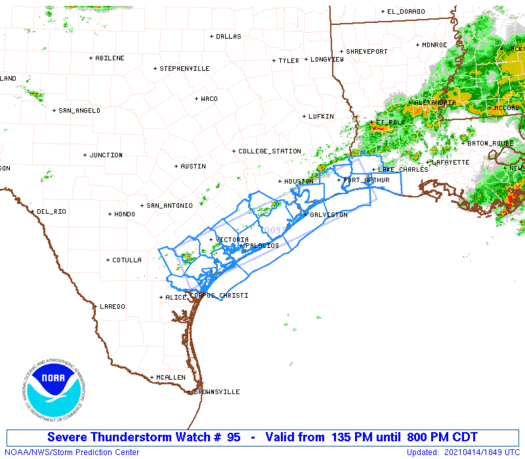
Severe Thunderstorm Watch Number 95
NWS Storm Prediction Center Norman OK
135 PM CDT Wed Apr 14 2021
The NWS Storm Prediction Center has issued a
* Severe Thunderstorm Watch for portions of
Extreme southwest Louisiana
The Middle and Upper Texas Coastal Plains
Coastal Waters
* Effective this Wednesday afternoon and evening from 135 PM
until 800 PM CDT.
* Primary threats include...
Scattered large hail and isolated very large hail events to 2
inches in diameter possible
Isolated damaging wind gusts to 70 mph possible
SUMMARY...Widely scattered thunderstorm development is expected by
mid afternoon from the Middle Texas Coastal Plain northeastward to
extreme southwest Louisiana. The storm environment will favor a mix
of multicell clusters and some supercell structures, with an
attendant threat for large hail and isolated damaging gusts into
this evening.
The severe thunderstorm watch area is approximately along and 30
statute miles either side of a line from 55 miles southwest of
Victoria TX to 40 miles east of Port Arthur TX. For a complete
depiction of the watch see the associated watch outline update
(WOUS64 KWNS WOU5).
PRECAUTIONARY/PREPAREDNESS ACTIONS...
REMEMBER...A Severe Thunderstorm Watch means conditions are
favorable for severe thunderstorms in and close to the watch area.
Persons in these areas should be on the lookout for threatening
weather conditions and listen for later statements and possible
warnings. Severe thunderstorms can and occasionally do produce
tornadoes.
&&
AVIATION...A few severe thunderstorms with hail surface and aloft to
2 inches. Extreme turbulence and surface wind gusts to 60 knots. A
few cumulonimbi with maximum tops to 550. Mean storm motion vector
27015.
...Thompson
   SEL5

   URGENT - IMMEDIATE BROADCAST REQUESTED
   Severe Thunderstorm Watch Number 95
   NWS Storm Prediction Center Norman OK
   135 PM CDT Wed Apr 14 2021

   The NWS Storm Prediction Center has issued a

   * Severe Thunderstorm Watch for portions of
     Extreme southwest Louisiana
     The Middle and Upper Texas Coastal Plains
     Coastal Waters

   * Effective this Wednesday afternoon and evening from 135 PM
     until 800 PM CDT.

   * Primary threats include...
     Scattered large hail and isolated very large hail events to 2
       inches in diameter possible
     Isolated damaging wind gusts to 70 mph possible

   SUMMARY...Widely scattered thunderstorm development is expected by
   mid afternoon from the Middle Texas Coastal Plain northeastward to
   extreme southwest Louisiana.  The storm environment will favor a mix
   of multicell clusters and some supercell structures, with an
   attendant threat for large hail and isolated damaging gusts into
   this evening.

   The severe thunderstorm watch area is approximately along and 30
   statute miles either side of a line from 55 miles southwest of
   Victoria TX to 40 miles east of Port Arthur TX. For a complete
   depiction of the watch see the associated watch outline update
   (WOUS64 KWNS WOU5).

   PRECAUTIONARY/PREPAREDNESS ACTIONS...

   REMEMBER...A Severe Thunderstorm Watch means conditions are
   favorable for severe thunderstorms in and close to the watch area.
   Persons in these areas should be on the lookout for threatening
   weather conditions and listen for later statements and possible
   warnings. Severe thunderstorms can and occasionally do produce
   tornadoes.

   &&

   AVIATION...A few severe thunderstorms with hail surface and aloft to
   2 inches. Extreme turbulence and surface wind gusts to 60 knots. A
   few cumulonimbi with maximum tops to 550. Mean storm motion vector
   27015.

   ...Thompson
 Note:
The Aviation Watch (SAW) product is an approximation to the watch area.
The actual watch is depicted by the shaded areas.
Note:
The Aviation Watch (SAW) product is an approximation to the watch area.
The actual watch is depicted by the shaded areas.
SAW5
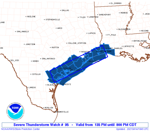
WW 95 SEVERE TSTM LA TX CW 141835Z - 150100Z
AXIS..30 STATUTE MILES EITHER SIDE OF LINE..
55SW VCT/VICTORIA TX/ - 40E BPT/PORT ARTHUR TX/
..AVIATION COORDS.. 25NM EITHER SIDE /24NNW CRP - 17SW LCH/
HAIL SURFACE AND ALOFT..2 INCHES. WIND GUSTS..60 KNOTS.
MAX TOPS TO 550. MEAN STORM MOTION VECTOR 27015.
LAT...LON 28699774 30359353 29549317 27889738
THIS IS AN APPROXIMATION TO THE WATCH AREA. FOR A
COMPLETE DEPICTION OF THE WATCH SEE WOUS64 KWNS
FOR WOU5.
Watch 95 Status Report Message has not been issued yet.
Note:
Click for Complete Product Text.
Tornadoes
Probability of 2 or more tornadoes
|
Low (10%)
|
Probability of 1 or more strong (EF2-EF5) tornadoes
|
Low (<2%)
|
Wind
Probability of 10 or more severe wind events
|
Mod (30%)
|
Probability of 1 or more wind events > 65 knots
|
Low (20%)
|
Hail
Probability of 10 or more severe hail events
|
Mod (40%)
|
Probability of 1 or more hailstones > 2 inches
|
Mod (30%)
|
Combined Severe Hail/Wind
Probability of 6 or more combined severe hail/wind events
|
High (70%)
|
For each watch, probabilities for particular events inside the watch
(listed above in each table) are determined by the issuing forecaster.
The "Low" category contains probability values ranging from less than 2%
to 20% (EF2-EF5 tornadoes), less than 5% to 20% (all other probabilities),
"Moderate" from 30% to 60%, and "High" from 70% to greater than 95%.
High values are bolded and lighter in color to provide awareness of
an increased threat for a particular event.


 @NWSSPC


